Jose Panganiban, Camarines Norte
| Jose Panganiban | ||
|---|---|---|
| Municipality | ||
| Municipality of Jose Panganiban | ||
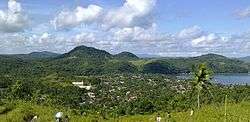 Jose Panganiban, Camarines Norte | ||
| ||
| Motto(s): Alay sa Diyos at sa Bayan | ||
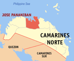 Map of Camarines Norte with Jose Panganiban highlighted | ||
.svg.png) Jose Panganiban Location within the Philippines | ||
| Coordinates: 14°18′N 122°42′E / 14.3°N 122.7°ECoordinates: 14°18′N 122°42′E / 14.3°N 122.7°E | ||
| Country |
| |
| Region | Bicol Region (Region V) | |
| Province | Camarines Norte | |
| District | 1st district | |
| Founded | 1571 | |
| Renamed | December 1, 1934 | |
| Named for | Jose Maria Panganiban | |
| Barangays | 27 (see Barangays) | |
| Government [1] | ||
| • Type | Sangguniang Bayan | |
| • Mayor | Ricarte Robledo Padilla | |
| • Vice Mayor | Ariel Mimay Non | |
| • Electorate | 29,187 voters (2016) | |
| Area [2] | ||
| • Total | 214.44 km2 (82.80 sq mi) | |
| Population (2015 census)[3] | ||
| • Total | 59,639 | |
| • Density | 280/km2 (720/sq mi) | |
| Time zone | UTC+8 (PST) | |
| ZIP code | 4606 | |
| PSGC | 051605000 | |
| IDD : area code | +63 (0)54 | |
| Climate type | Tropical rainforest climate | |
| Income class | 2nd municipal income class | |
| Revenue (₱) | 138,943,962.40 (2016) | |
| Native languages |
Manide Tagalog | |
| Website |
mambulao | |

Jose Panganiban, officially the Municipality of Jose Panganiban, is a 2nd class municipality in the province of Camarines Norte, Philippines. According to the 2015 census, it has a population of 59,639 people.[3]
The municipality was formerly known as Mambulao, a word taken from “mambulawan,” meaning bountiful in gold. It was renamed to honor Jose Maria Panganiban on December 1, 1934.[4]
Barangays
Jose Panganiban is politically subdivided into 27 barangays.
- Bagong Bayan
- Calero
- Dahican
- Dayhagan
- Larap
- Luklukan Norte
- Luklukan Sur
- Motherlode
- Nakalaya
- Osmeña
- Pag-Asa
- Parang
- Plaridel
- North Poblacion
- South Poblacion
- Salvacion
- San Isidro
- San Jose
- San Martin
- San Pedro
- San Rafael
- Santa Cruz
- Santa Elena
- Santa Milagrosa
- Santa Rosa Norte
- Santa Rosa Sur
- Tamisan
Demographics
| Population census of Jose Panganiban | |||||||||||||||||||||||||||||||||||||||||||||||||
|---|---|---|---|---|---|---|---|---|---|---|---|---|---|---|---|---|---|---|---|---|---|---|---|---|---|---|---|---|---|---|---|---|---|---|---|---|---|---|---|---|---|---|---|---|---|---|---|---|---|
|
| ||||||||||||||||||||||||||||||||||||||||||||||||
| Source: Philippine Statistics Authority[3][5][6][7] | |||||||||||||||||||||||||||||||||||||||||||||||||
In the 2015 census, the population of Jose Panganiban was 59,639 people,[3] with a density of 280 inhabitants per square kilometre or 730 inhabitants per square mile.
Religions
Christian churches:
- Ang Dating Daan
- Assemblies of God
- Body of Christ Bible Church
- City Of Praise
- Iglesia Ni Cristo
- Kingdom Hall of Jehovah's Witnesses
- Seventh-day Adventist
- The Church of Jesus Christ of Latter-day Saints
Roman Catholic churches:
- Parish of Our Lady of the Most Holy Rosary
- Parish of Saint Roch in Larap
Economy
Mining
It is known that even before the colonizers came, Mambulao was already a flourishing mining town. It was the Spaniards, drawn by the rumor of immense gold deposits in the Mambulao-Paracale district, who mastered in exploring the gold mining potentials of these towns.
From the 1750s to 1800s, Paracale held the major Spanish mines, but due to its closure in the 1790s, its people were living in desultory gold washing, fishing and selling betel nut to Mambulao which has now became the mining center. During that time, there were plenty of small shops but there’s no rice fields and vegetable gardening. All necessities came from Ambos Camarines and Tayabas (Quezon). Fifteen years later, the mines of Mambulao were no longer open. There was still some haphazard gold washing by women of Indio Class whose husbands, it was alleged, gambled away their meager earning in card games run by the town mayor. But by 1818, the population was back to the levels of the 1790s and by the mid-1820s annual gold production levels ran as 3,200 ounces (90.7 kg.) worth Php. 44,000 at prevailing prices. By 1829, Camarines Norte was considered to be wealthy and populous enough to warrant separation as province of its own for the first time. But after the 1840s the mining and population declined. Dr. Fedor Jagor (in his book Travels in the Philippines and The former Philippines thru Foreign Eyes), a well known German traveler who visited Mambulao in 1859, reported that it was thinly populated and that the mining mania was already ruined.[8] From 1837 to 1876 the population of Mambulao and Paracale decreased by 30%.
From 1900 until the early twenties, Mambulao was a sleepy town, isolated from the other towns of Camarines Norte. During the gold bloom, it was dubbed as “Little Manila”, due to flourishing business operated by Filipinos, Chinese, Japanese, Syrians and many others. Dutch-born Filipino citizen Jan Hendrik Marsman operated two rich mines during the American occupation, a substantial dredging operation and the Philippines only smelter located in the Mambulao- Paracale district. The population quadrupled between 1918 and 1938. One of the most notable mining company to operate in this municipality is the Philippine Iron Mines, then the largest iron mine in Asia.
Mining companies operating in Jose Panganiban include:
- Philippine Iron Mines (defunct) 1925 to 1975, then biggest iron mine in Asia
- San Mauricio Mining Company (defunct) 1933
- Benguet Gold Mining Corporation (defunct)
- Motherlode Mining Company (defunct)
- J. G. Realty and Mining Company (defunct) 1987-1997
- Johson Gold Mining Corporation[9]
- Investwell Mining (mining arm of Isabelo Fonacier Mining)[10]
- Ferro Management and Consultancy Group Inc. (FMCGI) 2008
Jose Panganiban Special Economic Zones
- JPSEZ(1) Situated in Barangay Larap, Jose Panganiban created under Presidential Proclamation No. 508, s. 2003 and now recognised as Global Industrial/Maritime Complex.[11][12]
- JPSEZ(2) Situated in Barangay Osmena, Jose Panganiban. Pan Century Surfactants Inc. under the Aditya Birla Group operates in the area.[13]
Places of interest
Historical landmarks
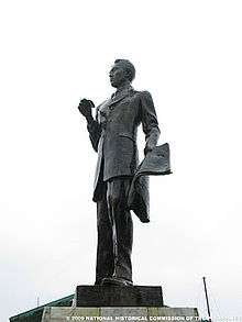
- Jose Maria Panganiban Monument - installed on February 1, 1985 by the National Historical Institute which contains the remains of the home-grown hero[14]
- Roy Padilla Sr. Monument - located inside Doña Ponay park, is a monument installed as a remembrance to Governor Casimero Ruiz Padilla, father of famous and political personalities in the Philippines today. Known for his excellent leadership skill, he was undefeated in all of his political campaigns. He was assassinated in Labo, Camarines Norte at the age of 61.
Islands and beach destinations
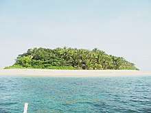
- Parola Island - a popular island destination in Jose Panganiban famous for its pink sand shoreline, powdery beach, and clear blue water. The island got its name from a small light tower found in the island which guides fishermen at night. Tourists are advised to contact the Municipal Tourism Office when planning to visit the island.[15]
- Calalanay Island - This small island is a 30-minute boat ride from Larap Port. It is locally known for its white sand beach and clear blue water coming from the Philippine Sea. Tourists are advised to contact the Municipal Tourism Office when planning to visit the island.[16]
- Isla ni Cion - Aside from its long stretch of white sand beach, Isla ni Cion boasts of its mangrove eco-park which the locals proudly take care of. A bamboo walkway will lead tourists through this dense mangrove forest. Visitors can take a boat ride from Larap port to reach this area.[17]
- Pag-asa Beach - located in Brgy. Pag-asa, this popular beach destination for locals is heavily visited during the months of March, April, and May. Small cottages and a public restroom are maintained by locals.[18]
- Bulalacao Beach - a 30-minute travel, via motorcycle, tricycle, jeepney or your own vehicle, from the town proper, will get you to Bulalacao Beach in Brgy. Luklukan Sur. The beach is named after meteor sightings by locals. Scenic views along the road will welcome tourists on their way to the beach. Bringing your own tent (tolda) or picnic table is advisable for groups visiting the area.
Other local spots
- Fil-Nippon Fountain of Friendship Park - located in Brgy. North Poblacion, Fil-Nippon Fountain of Friendship Park (or simply known as Fountain) is a park built as a symbol of friendship between Filipinos and Japanese and as a remembrance of the town's rich history with the Japanese during the time of Philippine Iron Mines.
- Doña Ponay Park - located in Brgy. South Poblacion, Doña Ponay park is built as a remembrance to Doña Apolinaria de los Reyes, popularly known as Doña Ponay, a former resident of Monte Calogcog (now known as Brgy. Luklukan Norte). Her most popular story was her gift to Queen Isabella of Spain; a life-size hen with 12 chicks standing on a platter made of solid gold.[19]
- Mambulao Boardwalk - located in Brgy. North Poblacion, adjacent to Fil-Nippon Fountain of Friendship Park, Mambulao Boardwalk is a popular spot for locals to see the sun setting over Mambulao Bay.
- Turayog Resort - located in Brgy. Luklukan Norte, Turayog Resort is increasingly becoming popular among tourists and locals with its viewing deck which gives a 360-degree view of the town of Jose Panganiban.
Infrastructure
Airport and Seaports
The Larap (Jose Panganiban) Airport (ICAO Code: RPUP), formerly operated by the Philippine Iron Mines, covers an area of approximately 35 hectares and with existing 1,400 meter stretched runway.[20] It is located at Latitude 14°17′28″N Longitude 122°38′46″E.
In January 2018, mobilization for the construction of Larap Regional Airport immediately began after the ceremonial groundbreaking of Larap Integrated Development Project. Penson and Company, Inc., who will build and operate the airport, expects to rehabilitate the existing 1400 meter runway by 2018 then upgrade its length to 1900–2000 meters by 2019.[21] The airport is expected to operate commercially by 2021.[22]
The nearest commercial airports that operate regularly are Naga Airport (126 km away) in Pili, Camarines Sur and Legazpi Airport (216 km away) in Albay.
The International Port of Jose Panganiban (Latitude 14° 17’N Longitude 122° 42’E) is nearly 2 miles wide at the entrance between Calambayungan Island and Pinandungan Point and with sea distance to Manila of 468.10 nautical miles.The port is situated at Barangay Osmeña which is approximately five (5) kilometers away from the town proper of Jose Panganiban. The port serves as the passage of all water borne traffic to and from the Paracale mining area, Larap., Lucena, other Quezon town and the rest of Bicol and Visayas provinces. Copra, coconut oil and copra pellets used to be its principal exports.[23][24]
The Port of Larap Bay is a natural coastal harbor situated at Barangay Larap (Latitude 14° 18' 36" N Latutude 122° 39' 0" E), currently serving the needs of a local mining company. The harbor entrance is restricted due to swell.[25][26]
Public Land Transportation
The municipal's public transportation needs are provided by Tricycles, Jeepneys (Route: Downtown to Mountainous Villages), Vans (Route: Jose Panganiban to Daet), and Buses (Routes: Jose Panganiban to Daet via Labo, Jose Panganiban to Tabaco, Albay via Naga City, and Jose Panganiban to Metro Manila). Philtranco, Superlines, and DLTB serve the Jose Panganiban/Paracale-Metro Manila route.
Electricity and Water Supply
Jose Panganiban is being served by the National Power Corporation through CANORECO (Camarines Norte Electric Cooperative). A Coal Power Plant is set to be built by H and WB Asia Pacific Pte. Ltd. by 4th quarter of 2017 which is expected to generate a total of 700 Megawatts of power supply by 2025.[27][28]
Water supply and treatment is provided by Jose Panganiban Water District, a local cooperative, via a system of pumps and pipes, sourcing its supply from ground water and dam.
Communication
Mambulao Cable Television and JP Cable TV System provide digital cable services and fixed-line internet connection throughout the municipality. Smart Communications, Globe Telecom, and Sun Cellular are the mobile, fixed-line, broadband, 3G and 4G internet service providers. International Calls are provided by the Local Government for free. Town FM 89.3 also broadcasts from the municipality.
Medical Institutions
- Jose Panganiban Rural Health Unit 1 - Barangay South Poblacion (East District)
- Jose Panganiban Rural Health Unit 2 - Barangay Larap (West District)
- Jose Panganiban Primary Hospital Services Coop. - Barangay North Poblacion
- Barrios-Busiños Medical Clinic and Hospital - Barangay Sta. Rosa Norte
Educational institutions
Post-secondary
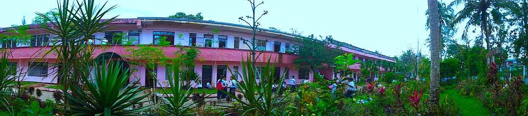
- Camarines Norte State College - Jose Panganiban Campus (College of Engineering and Industrial Technology) formerly Camarines Norte School of Arts and Trades
- Roy Padilla Sr. (JP) Memorial Technical and Vocational Training Center (TESDA-accredited)
Public Secondary
- Jose Panganiban National High School
- Larap National High School
- Sta. Cruz National High School
- Gawad Kalinga High School
Public Primary
|
West District:
|
East District:
|
Private Schools
Listed below are private schools currently included in the Department of Education's Masterlist.[29]
- Montessori de Mambulao Learning Centre - Plaridel
- Wonderkids Science Montessori School - South Poblacion
- Ananda Marga Special Academic Institution - San Rafael
- Ave Maria Children's Center - North Poblacion
- St. Roch Children's Center - Larap
- Good Shepered Christian Learning Center -Plaridel
Radio stations
- Hot FM 94.3 - Jose Panganiban (Manila Broadcasting Corporation)
- Town FM 89.3 - Jose Panganiban
Sister Cities
Gallery
 Market Site
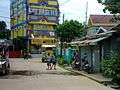
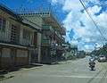 Jose Rizal Street
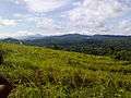 Sta. Rosa Norte
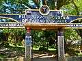 Fil-Nippon Fountain of Friendship Park
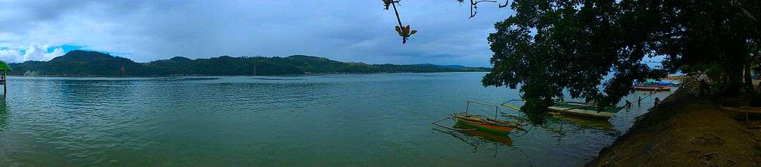
 Sunset viewed from a defunct seaport
See also
References
- ↑ "Municipality". Quezon City, Philippines: Department of the Interior and Local Government. Retrieved 31 May 2013.
- ↑ "Province: Camarines Norte". PSGC Interactive. Quezon City, Philippines: Philippine Statistics Authority. Retrieved 12 November 2016.
- 1 2 3 4 Census of Population (2015). "Region V (Bicol Region)". Total Population by Province, City, Municipality and Barangay. PSA. Retrieved 20 June 2016.
- ↑ "Municipal Profile". Official Website of Jose Panganiban. Archived from the original on 19 January 2013. Retrieved 31 December 2012.
- ↑ Census of Population and Housing (2010). "Region V (Bicol Region)". Total Population by Province, City, Municipality and Barangay. NSO. Retrieved 29 June 2016.
- ↑ Censuses of Population (1903–2007). "Region V (Bicol Region)". Table 1. Population Enumerated in Various Censuses by Province/Highly Urbanized City: 1903 to 2007. NSO.
- ↑ "Province of Camarines Norte". Municipality Population Data. Local Water Utilities Administration Research Division. Retrieved 17 December 2016.
- ↑ "Travels in the Philippines" (English) Reisen in den Philippinen. Chapman and Hall, London 1875
- ↑ http://www.johsongold.com/
- ↑ http://newsinfo.inquirer.net/38473/denr-execs-want-to-regulate-small-scale-mining
- ↑ http://www.gov.ph/2003/12/02/proclamation-no-508-s-2003/
- ↑ http://www.peza.gov.ph/contents/Top%20Bar/.../Manufacturing.docx
- ↑ http://www.business-in-asia.com/philippines/ph_economic_zones.html
- ↑ http://nhcphistoricsites.blogspot.com/2011/11/jose-ma-panganiban-y-enverga-monument.html
- ↑ http://thejerny.com/travel/parola-island-pink-beach-camarines-norte/
- ↑ http://mambulaoansworldwidebuzz.blogspot.com/2012/03/photo-essay-beaches-to-walk-on-this.html
- ↑ https://www.nomadicexperiences.com/2016/03/a-date-with-daet-camarines-norte.html
- ↑ https://www.vigattintourism.com/tourism/articles/Pag-asa-Beach
- ↑ http://mambulaoansworldwidebuzz.blogspot.com/2013/07/donya-ponay-relived-in-new-book.html
- ↑ "Infrastracure". Archived from the original on 2012-12-28.
- ↑ http://penson.ph/larap-integrated-development-project-lidp/
- ↑ http://bicol.da.gov.ph/index.php/news/3328-bicol-local-chief-executives-integrate-p976-04-million-rpab-approved-prdp-subprojects-in-master-plans
- ↑ http://www.pdosoluz.com.ph/terminal-port-of-jose-panganiban.html
- ↑ http://www.anchorageworld.com/content/jose-panganiban%5Bpermanent+dead+link%5D
- ↑ http://www.portarrivals.com/ports.asp?sec=Port&item=58090
- ↑ http://www.anchorageworld.com/content/larap-bay%5Bpermanent+dead+link%5D
- ↑ "Power Plant".
- ↑ https://hwbasiapacific.net/2-x-350-mw-coal-fired-power-plant-in-jose-panganiban-camarines-norte-province/
- ↑ "List of Schools acknowledged by the Department of Education".
- ↑ "Archived copy". Archived from the original on 2013-07-01. Retrieved 2012-11-27.
- ↑ http://camnortenews.com/page/?p=4481
External links
| Wikimedia Commons has media related to Jose Panganiban, Camarines Norte. |
- Jose Panganiban Official Website
- Jose Panganiban Website
- Philippine Standard Geographic Code
- Mambulaoans Worldwide Buzz
Places adjacent to Jose Panganiban, Camarines Norte | ||||||||||
|---|---|---|---|---|---|---|---|---|---|---|
| ||||||||||