Lagonoy, Camarines Sur
| Lagonoy | |
|---|---|
| Municipality | |
| Municipality of Lagonoy | |
 | |
| Nickname(s): The True Heart of Partido | |
| Motto(s): Dagos Ang Pagasenso | |
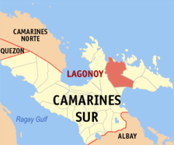 Map of Camarines Sur with Lagonoy highlighted | |
.svg.png) Lagonoy Location within the Philippines | |
| Coordinates: 13°44′N 123°31′E / 13.73°N 123.52°ECoordinates: 13°44′N 123°31′E / 13.73°N 123.52°E | |
| Country |
|
| Region | Bicol Region (Region V) |
| Province | Camarines Sur |
| District | 4th district |
| Founded | 1763 |
| Barangays | 38 (see Barangays) |
| Government [1] | |
| • Type | Sangguniang Bayan |
| • Mayor | Delfin "JB" F. Pilapil III |
| • Vice Mayor | Ben Saboco |
| • Electorate | 31,983 voters (2016) |
| Area [2] | |
| • Total | 377.90 km2 (145.91 sq mi) |
| Population (2015 census)[3] | |
| • Total | 55,465 |
| • Density | 150/km2 (380/sq mi) |
| Time zone | UTC+8 (PST) |
| ZIP code | 4425 |
| PSGC | 051717000 |
| IDD : area code | +63 (0)54 |
| Climate type | Tropical rainforest climate |
| Income class | 2nd municipal income class |
| Revenue (₱) | 143,831,493.58 (2016) |
| Poverty incidence | 37.56 (2012)[4] |
| Native languages |
Central Bikol Tagalog |
Lagonoy, officially the Municipality of Lagonoy, is a 2nd class municipality in the province of Camarines Sur, Philippines. According to the 2015 census, it has a population of 55,465 people.[3]
Etymology
There are two version as how Lagonoy got its name. Year 1734 when the first Spaniards in this place found a small forested area near a creek where "hagonoy", a medicinal plant grew abundantly. Because the Spaniards could hardly pronounce the word "hagonoy" with the "j" sound, with "ha" of the first syllable, they deliberately decided to change "ha" to "la". Since then, the place was known as "Lagonoy". Some of the residents also believed that the name was taken from the word "lango" meaning drunk. During fiestas and other forms or merry making, men used to drink too much "tuba" (native wine) that they become drunk or "lango" (Bikol for drunk) so that the place was called by the neighboring towns as "Lagonoy".[5]
History
In 1734, Partido towns of Caramoan, Lagonoy, Goa and Tigaon belonged to Albay. It was only in 1846 did Lagonoy belong to Camarines Sur. In a long research by Norman Owen, a feud between Lagonoy Parish and Franciscan Mission of Goa and Tigaon existed. In 1580, the administration by the Franciscans of Lagonoy Parish began until 1636, which was passed to the “mitre” of the bishop of Nueva Caceres. In 1580 to 1850, Lagonoy gulf had been very famous because of the constant moro raids in the Partido area and all coastal towns of Albay and Catanduanes. On the other hand, Lagonoy had other problems about the Remontados of Mt Isarog. F. Mallari, in his book- “Ibalon under siege and storm” said they were fallen Christians and confirmed by Fray Manuel Crespo, who spent many years inducing them to return to the town and live peacefully. Fray Matias de Valdesoto also noted in his visits to the sitios of Goa and Lagonoy that the natives planted corn, rice, root crops & tobacco.
Barangays
Lagonoy is politically subdivided into 38 barangays.
- Agosais
- Agpo-Camagong-Tabog
- Amoguis
- Bocogan
- Balaton
- Binanuahan
- Burabod
- Cabotonan
- Dahat
- Del Carmen
- Ginorangan (Genorangan)
- Gimagtocon
- Gubat
- Guibahoy
- Himanag
- Kinahologan
- Loho
- Manamoc
- Mangogon
- Mapid
- Olas
- Omalo
- Panagan
- Panicuan
- Pinamihagan
- San Francisco (Poblacion)
- San Isidro
- San Isidro Sur (Poblacion)
- San Isidro Norte (Poblacion)
- San Rafael
- San Ramon
- San Roque
- San Sebastian
- San Vicente (Poblacion)
- Santa Cruz
- Santa Maria (Poblacion)
- Saripongpong (Poblacion)
- Sipaco
Demographics
| Population census of Lagonoy | |||||||||||||||||||||||||||||||||||||||||||||||||
|---|---|---|---|---|---|---|---|---|---|---|---|---|---|---|---|---|---|---|---|---|---|---|---|---|---|---|---|---|---|---|---|---|---|---|---|---|---|---|---|---|---|---|---|---|---|---|---|---|---|
|
| ||||||||||||||||||||||||||||||||||||||||||||||||
| Source: Philippine Statistics Authority[3][6][7][8] | |||||||||||||||||||||||||||||||||||||||||||||||||
In the 2015 census, the population of Lagonoy, Camarines Sur, was 55,465 people,[3] with a density of 150 inhabitants per square kilometre or 390 inhabitants per square mile.
Climate
| Climate data for Lagonoy, Camarines Sur | |||||||||||||
|---|---|---|---|---|---|---|---|---|---|---|---|---|---|
| Month | Jan | Feb | Mar | Apr | May | Jun | Jul | Aug | Sep | Oct | Nov | Dec | Year |
| Average high °C (°F) | 31 (88) |
30 (86) |
32 (90) |
35 (95) |
35 (95) |
35 (95) |
34 (93) |
33 (91) |
34 (93) |
32 (90) |
30 (86) |
30 (86) |
33 (91) |
| Average low °C (°F) | 26 (79) |
26 (79) |
28 (82) |
30 (86) |
31 (88) |
30 (86) |
29 (84) |
29 (84) |
29 (84) |
28 (82) |
27 (81) |
27 (81) |
28 (83) |
| Average precipitation mm (inches) | 82.88 (3.263) |
137.93 (5.4303) |
63.69 (2.5075) |
78.31 (3.0831) |
229.42 (9.0323) |
288.31 (11.3508) |
280.99 (11.0626) |
112.39 (4.4248) |
210.87 (8.302) |
599.07 (23.5854) |
194.80 (7.6693) |
454.3 (17.886) |
2,732.96 (107.5971) |
| Average rainy days | 24 | 28 | 18 | 20 | 24 | 29 | 31 | 27 | 27 | 30 | 29 | 31 | 318 |
| Source: World Weather Online[9] | |||||||||||||
Economy
Lagonoy is the chief supplier of "tiger grass" to the prominent "walis tambo makers" of North Luzon and some parts of Central Luzon.
References
- ↑ "Municipality". Quezon City, Philippines: Department of the Interior and Local Government. Retrieved 31 May 2013.
- ↑ "Province: Camarines Sur". PSGC Interactive. Quezon City, Philippines: Philippine Statistics Authority. Retrieved 12 November 2016.
- 1 2 3 4 Census of Population (2015). "Region V (Bicol Region)". Total Population by Province, City, Municipality and Barangay. PSA. Retrieved 20 June 2016.
- ↑ "PSA Releases the 2012 Municipal and City Level Poverty Estimates". Quezon City, Philippines: Philippine Statistics Authority. Archived from the original on 28 January 2017. Retrieved 28 January 2017.
- ↑ Cultural Inventory of the 4th District of Camarines Sur (Project in Social Science 4 classes, A/Y 2001- 2002
- ↑ Census of Population and Housing (2010). "Region V (Bicol Region)". Total Population by Province, City, Municipality and Barangay. NSO. Retrieved 29 June 2016.
- ↑ Censuses of Population (1903–2007). "Region V (Bicol Region)". Table 1. Population Enumerated in Various Censuses by Province/Highly Urbanized City: 1903 to 2007. NSO.
- ↑ "Province of Camarines Sur". Municipality Population Data. Local Water Utilities Administration Research Division. Retrieved 17 December 2016.
- ↑ "Lagonoy, Camarines Sur: Average Temperatures and Rainfall". World Weather Online. Retrieved 29 October 2017.
External links
| Wikimedia Commons has media related to Lagonoy, Camarines Sur. |
- Philippine Standard Geographic Code
- Philippine Census Information
- Official Site of the Province of Camarines Sur
Places adjacent to Lagonoy, Camarines Sur | |
|---|---|
Pili (capital) | |
| Municipalities | |
| Component city | |
| Independent component city |
|