Mount Isarog
| Mount Isarog | |
|---|---|
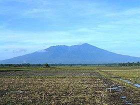 The mountain as seen from San Jose | |
| Highest point | |
| Elevation | 2,000 m (6,600 ft) [1][2] |
| Prominence | 1,951 m (6,401 ft) [1] |
| Listing | |
| Coordinates | 13°39′33″N 123°22′24″E / 13.65917°N 123.37333°ECoordinates: 13°39′33″N 123°22′24″E / 13.65917°N 123.37333°E [1][3] |
| Geography | |
.svg.png) Mount Isarog Location within the Philippines | |
| Location | Luzon |
| Country | Philippines |
| Region | Bicol Region |
| Province | Camarines Sur |
| Cities and municipalities | |
| Geology | |
| Mountain type | Stratovolcano |
| Last eruption | 3500 BCE[4] |
| Climbing | |
| Easiest route | Concosep, Tigaon, Camarines Sur Route |
Mount Isarog is a potentially active stratovolcano located in the province of Camarines Sur, Philippines, on the island of Luzon. It has an elevation of 2,000 metres above mean sea level.[1]
The peak of the mountain marks the point where the borders of five municipalities and one city meet (listed in clockwise direction, starting north): Goa, Tigaon, Ocampo, Pili, Naga City, and Calabanga.
Mount Isarog was where local troops of the Philippine Army and Constabulary units and Bicolano guerrillas hid during the Japanese Period. In the 1970s, with the leadership of Romulo Jallores and his brother, they established the New People's Army in the Bicol region at the foot of this mountain.[5]
History
Indigenous History
Mount Isarog has been the ancestral territory of the indigenous Isarog Agta people for thousands of years prior to the arrival of the Spanish. They are one of the first inhabitants in the entire Philippines and are of Negrito origin. They are a group of Aeta people with a distinct language and heritage unique from others.
Legal History
It was made a public land through the Proclamation No. 157 on March 28, 2015. Towns around it is classified as timberland forest with an area of 13,433 hectares (33,190 acres).
On August 17, 1935, General Frank Murphy established the Mt. Isarog Forest Reserve which reduced the size of the area to 10,112. But it was revoked by President Manuel L. Quezon when he signed Proclamation No. 293 titled "Establishment of Mt. Isarog as a National Park."[6]
On June 1, 1992, with the passage of Republic Act 7586 known as the National Integrated Protected Areas System or NIPAS, Mt. Isarog was National Integrated Protected Area Programme. On June 20, 2002, by virtue of Proclamation No. 214, Mt. Isarog became a protected area under the natural park.[7]
Isarog Agta Language
In 2010, UNESCO released its 3rd world volume of Endangered Languages in the World, where 3 critically endangered languages were in the Philippines. One of these languages in the Isarog Agta language which has an estimated speaker of 5 people in the year 2000. The language was classified as Critically Endangered, meaning the youngest speakers are grandparents and older, and they speak the language partially and infrequently and hardly pass the language to their children and grandchildren anymore. If the remaining 150 people do not pass their native language to the next generation of Isarog Agta people, their indigenous language will be extinct within a period of 1 to 2 decades.
The Isarog Agta people live within the circumference of Mount Isarog, though only 5 of them still know their indigenous language. They are one of the original Negrito settlers in the entire Philippines. They belong to the Aeta people classification, but have distinct language and belief systems unique to their own culture and heritage.
Biodiversity
Mt. Isarog has a rich diversity. It displays four major types of natural habitat or vegetation; from the warm grassland and lowland forest to the wet and cool climate of montane forest.
| Types | Altitude (meters asl.) |
|---|---|
| Lowland Forest | 500-900 |
| Grassland | 700-1,200 |
| Montane Forest | 1,000-1,400 |
| Mossy Forest | 1,500-to the summit |
The lowland forest is noted for its tall canopy. The uppermost layer towers between 30–40 meters and sometimes even reach 60 meters. Many of these trees belong to the dipterocarp family. The second canopy layer (between 23–30 meters) has the sustain bamboos (Bambusa), arborescent palms (Calamus), climbing bammboo (Schizostacyum), climbing pandans (Freycinetia) and vascular epiphytes such as orchids and ferns.
The grassland (parang) is dominated by cogon (Imperata cylindrica) and talahib (Saccharum ovatum) grasses. The topography and soil condition of the area limits the growth of trees, giving rise to the grassland.
The montane forest has two-oken because layered canopy trees ranging from 12–25 meters with noticeable canopy gaps due to the absence of large trees.
The mossy forest has a canopy with a small height of 2 to 6 meters only. The canopy is broken because of the high winds and steep terrain. It is inhabited by bamboo, pandan, orchids, ferns, pitcher plants and other epiphytes. Trees at this level are covered with moss.
Endemic
Isarog Shrew rat (Rhynchomys isarogensis) was first discovered in 1988 in Mount Isarog. Although it has no direct economic value, its presence in Mount Isarog is a barometer of wealth and management of its natural resources. It is now listed as endangered in the Red Data Book of the International Union for Conservation of Nature.[8]
Mt. Isarog is included as a protected area, home to endemic rodents (Archboldomys luzonensis, Chrotomys gonzalesi and Rhynchomys isarogensis), other endemic mammals, and 15 bird species endemic to Luzon.
Isarog Cloud Frog was first described by scientists in 1997. In total, scientists have identified one and possibly three new frog species, 8 species of snakes, and 19 species of lizards.
Mt. Isarog also has the rare Mt. Isarog Forest Skink (Sphenomorphus knollmanae) that is Endemic.[8]
See also
References
- 1 2 3 4 "Philippines Mountains" - Ultra Prominence Page. Peaklist.org. Retrieved 2012-03-30.
- ↑ = 12955 "Mount Isarog, Philippines" Peakbagger.com. Retrieved 2012-03-30.
- ↑ "Isarog". Global Volcanism Program. Smithsonian Institution.
- ↑ https://volcano.si.edu/volcano.cfm?vn=273042
- ↑ Gerona, Danillo (June–July 1993) [1993]. "Isarog Through the Years". The Bikol Executive. 1. pp. 21–22.
- ↑ "Proclamation No. 293; Establishing as Mount Isarog National Park for the Benefit and Enjoyment of the People of the Philippines the Parcel of Land Situated in the Municipalities of Naga, Calabanga, Tinambac, Goa, Tigaon and Pili, Province of Camarines Sur, Island of Luzon, and Revoking for This Purpose Proclamation No. 840, Series of 1935". Official Gazette of the Republic of the Philippines. Malacañan Palace, Manila, Philippines. 20 July 1938. Retrieved 10 March 2016.
- ↑ "Proclamation No. 214; Declaring the Mt. Isarog National Park Situated in the City of Naga and Municipalities of Calabanga, Tinambac, Tigaon, Goa, Ocampo and Pili, Province of Camarines Sur, as a Protected Area Pursuant to Republic Act 7586 (Nipas Act of 1992) to be Henceforth Known as Mt. Isarog Natural Park". Official Gazette of the Republic of the Philippines. Malacañan Palace, Manila, Philippines. 20 June 2002. Retrieved 10 March 2016.
- 1 2 "Rhynchomys isarogensis (Isarog Rhynchomys, Isarog Shrew-rat, Isarog Shrew Rat, Mt Isarog Shrew-rat)". www.iucnredlist.org. Retrieved 2015-09-30.
External links

- Phivolcs' Mount Isarog page
- "Mount Isarog, Philippines" on Peakbagger
| Administrative divisions |
|  | ||||
|---|---|---|---|---|---|---|
| Geography | ||||||
| History | ||||||
| Religion | ||||||
| Public utilities and services |
| |||||
| Transportation | ||||||
| Education | ||||||
| Landmarks | ||||||