List of state highways in Montana
| Montana Highway System | |
|---|---|
  Highway markers for MT 200, and S-323 | |
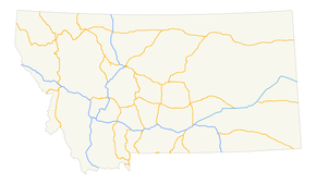 Map of main highways (Interstate and U.S.) | |
| System information | |
| Maintained by MDT | |
| Highway names | |
| Interstates | Interstate n (I-n) |
| US Highways | U.S. Highway n (US n) |
| State | Montana Highway n (MT n) |
| Secondary: | Secondary Highway n (S-n) |
| System links | |
The state highways in Montana are the state highways owned and maintained by the Montana Department of Transportation (MDT) in the U.S. state of Montana.
Primary state highways
The square markers used today to identify primary Montana highways are only slightly different from their 1940s and earlier predecessors. The old markers used the word "ROUTE" above the number in big size, the route number in the middle, and the word "MONTANA" from edge-to-edge at the sign bottom. The font used was similar to that used for US routes.
| Number | Length (mi)[1][2] | Length (km) | Southern or western terminus | Northern or eastern terminus | Formed | Removed | Notes |
|---|---|---|---|---|---|---|---|
| 63.652 | 102.438 | I-90 in Opportunity | I-90 in Drummond | 1922 | current | ||
| 63.241 | 101.777 | I-90 in Butte | I-90 in Three Forks | — | — | ||
| MT 3 | — | — | Idaho border near Heron | US 93 in Ravalli | — | — | Replaced by MT 200 |
| 221.770 | 356.904 | I-90 in Billings | I-15 and US 89 in Great Falls | — | — | ||
| MT 4 | 24 | 39 | Idaho state line | MT 3 in Thompson Falls | — | — | Replaced by Forest Service Road NF-7623 and S-471 |
| 65.573 | 105.530 | MT 13 in Scobey | ND 5 in Westby | — | — | ||
| MT 6 | — | — | US 10 Alternate in Townsend | US 10 in Forsyth | — | — | Replaced by US 12 |
| 80.585 | 129.689 | S-323 in Ekalaka | I-94 in Wibaux | 1930 | current | ||
| MT 8 | — | — | US 87 in Crow Agency | MT 22 near Olive | — | — | Replaced by US 212 |
| MT 9 | — | — | Lolo Pass | US 93 at Lolo | — | — | Replaced by US 12 |
| MT 11 | — | — | US 89 in Vaughn | Alberta border at Sweetgrass | — | 1934 | Replaced by US 91 |
| 112.507 | 181.062 | MT 200 in Circle | Hwy 36 at the Saskatchewan border | — | — | ||
| MT 14 | — | — | US 10 at Glendive | North Dakota border at Fairview | — | — | Replaced by MT 16 and MT 200 |
| MT 15 | — | — | US 87 in Stanford | US 2 in Chester | — | — | Replaced by MT 80 and S-223 |
| 152.371 | 245.217 | I-94 Bus. in Glendive | Hwy 6 at the Saskatchewan border | — | — | ||
| 14.082 | 22.663 | US 89 near Kennedy Creek | Hwy 6 at the Alberta border | — | — | ||
| MT 18 | — | — | US 87 in Grass Range | US 10 / MT 14 in Glendive | — | — | Replaced by MT 200 and MT 200S |
| MT 19 | — | — | US 10 in Big Timber | US 2 / MT 39 in Malta | — | — | Replaced by US 191 |
| 21.482 | 34.572 | US 87 and MT 200 near Grass Range | US 191 near Roy | — | — | ||
| MT 20 | — | — | US 10 in Bonner | US 89 near Great Falls | — | — | Replaced by MT 200 |
| 20.776 | 33.436 | US 287 near Augusta | MT 200 in Simms | — | — | ||
| MT 22 | — | — | Wyoming border at Alzada | Saskatchewan border at Port of Ophiem | — | — | Replaced by US 212, MT 59, S-341, and MT 24 |
| 7.527 | 12.114 | MT 16 and MT 200 near Sidney | ND 68 at the North Dakota border | — | — | ||
| MT 24 | 58 | 93 | MT 37 at Jennings | US 2 in Marion | — | — | |
| 134.098 | 215.810 | MT 200 near Brockway | Hwy 2 at the Saskatchewan border | — | — | ||
| 5.797 | 9.329 | US 2 in Wolf Point | MT 13 in Bridge Park | — | — | ||
| MT 26 | — | — | MT 3 in Trout Creek | US 2 in Kootenai National Forest | — | — | |
| MT 27 | — | — | MT 19 in Winifred | MT 29 in Big Sandy | — | — | Replaced by S-226 |
| 46.734 | 75.211 | MT 200 near Plains | US 93 in Elmo | — | — | ||
| MT 29 | — | — | US 87 / US 89 in Great Falls | Port of Wildhorse | — | — | Replaced by US 87 |
| MT 30 | — | — | US 12 near Miles City | South Dakota border near Mill Iron | — | — | |
| MT 31 | — | — | US 10 in Drummond | MT 35 near Bigfork | — | — | Replaced by S-271 and MT 83 |
| MT 32 | — | — | Yellowstone National Park at Silver Gate | US 310 at Rockvale | — | — | Replaced by US 212 |
| MT 33 | — | — | US 91 / MT 20 in Wolf Creek | US 89 in Choteau | — | — | Replaced by US 287 |
| MT 34 | — | — | MT 41 in Twin Bridges | MT 287 in Ennis | — | — | Replaced by MT 287 |
| 50.669 | 81.544 | US 93 in Polson | US 2 in Evergreen | — | — | ||
| MT 36 | — | — | US 93 near Gibbons Pass | US 91 in Dillon | — | — | Replaced by MT 43 and S-278 |
| 67.048 | 107.903 | US 2 in Libby | US 93 in Eureka | — | — | ||
| 53.835 | 86.639 | US 93 in Grantsdale | MT 1 in Porters Corner | 1924 | current | Skalkaho Highway | |
| 51.163 | 82.339 | US 212 in Lame Deer | North of I-94 near Forsyth | — | — | ||
| 4.505 | 7.250 | US 93 south of Whitefish | US 2 west of Columbia Falls | — | — | ||
| 54.512 | 87.729 | I-15 Bus. in Dillon | MT 2 in Vendome Station | — | — | ||
| 2.892 | 4.654 | MT 24 south of Glasgow | US 2 in Glasgow | — | — | ||
| 77.462 | 124.663 | US 93 at Lost Trail Pass | I-15 near Divide | — | — | Last mile near western terminus with US 93 is in Idaho. | |
| 28.390 | 45.689 | US 93 north of Dupuyer | I-15 east of Valier | — | — | ||
| MT 45 | — | — | MT 8 in Lame Deer | US 10 in Forsyth | — | — | Replaced by MT 39 |
| 31.437 | 50.593 | I-90 in Hardin | I-94 east of Custer | — | — | ||
| 6.839 | 11.006 | MT 1 near Anaconda | I-90 near Warm Springs | — | — | ||
| 11.734 | 18.884 | US 2 in East Glacier Park | US 89 north of Kiowa | — | — | ||
| MT 50 | — | — | Idaho border at Raynolds Pass | US 287 west of Lake Hebgen | — | — | Replaced by MT 87 |
| 12.996 | 20.915 | MT 41 north of Silver Star | I-90 at Whitehall | — | — | ||
| 34.646 | 55.757 | MT 200 west of Noxon | US 2 east of Troy | — | — | ||
| 195.389 | 314.448 | WYO 59 at the Wyoming border | MT 200 at Jordan | — | — | ||
| 9.039 | 14.547 | Big Sky Resort | US 191 near Big Sky Resort | — | — | ||
| 50.022 | 80.503 | US 191 south of Landusky | US 2 at Fort Belknap | — | — | ||
| 38.395 | 61.791 | MT 55 at Whitehall | I-15 at Boulder | — | — | ||
| 21.408 | 34.453 | WYO 120 at the Wyoming border | US 310 south of Bridger | — | — | ||
| 47.714 | 76.788 | US 212 at Red Lodge | I-90 at Columbus | — | — | ||
| 67.172 | 108.103 | US 87 at Stanford | US 87 at Fort Benton | — | — | ||
| 42.446 | 68.310 | MT 80 near Coffee Creek | US 191 at Brooks | — | — | ||
| 6.862 | 11.043 | US 93 north of Somers | MT 82 north of Bigfork | 1978 | current | ||
| 91.118 | 146.640 | MT 200 at Clearwater Junction | MT 35 north of Bigfork | 1978 | current | ||
| 28.904 | 46.516 | US 287 in Norris | US 191 / MT 85 near Four Corners | — | — | ||
| 6.704 | 10.789 | US 191 / MT 84 near Four Corners | I-90 at Belgrade | — | — | ||
| 37.498 | 60.347 | US 191 / I-90 Bus. in Bozeman | US 89 near Wilsall | — | — | ||
| 8.571 | 13.794 | SH-87 at the Idaho border | US 287 west of Quake Lake | 1987 | current | ||
| MT 110 | — | — | US 10 near Opportunity | US 10 in Drummond | — | — | Replaced by US 10 Alternate |
| 13.138 | 21.144 | MT 24 at Fort Peck | US 2 at Nashua | — | — | ||
| 21.549 | 34.680 | I-90 at St. Regis | MT 200 near Paradise | — | — | ||
| 32.468 | 52.252 | US 12 at Avon | MT 200 north of Helmville | — | — | ||
| MT 187 | — | — | US 10 in Bozeman | US 89 in Wilsall | — | — | Replaced by MT 86 |
| MT 191 | — | — | US 191 near Grayling | US 10 near Sappington | — | — | Replaced by US 287 |
| 706.624 | 1,137.201 | SH-200 at the Idaho border | ND 200 at Fairview | 1967 | current | ||
| 48.674 | 78.333 | MT 200 east of Circle | US 10 / I-94 Bus. in Glendive | — | — | ||
| 48.822 | 78.571 | MT 41 at Twin Bridges | US 287 at Ennis | — | — | ||
| MT 789 | — | — | Wyoming border south of Warren | Alberta border at Sweetgrass | — | — | Part of US 789 corridor |
Secondary state highways
The highway markers for Montana's S routes are distinctive in that the route number appears in black on a white down-pointing arrowhead. (Early markers were white numbers on black arrowheads with the word Montana in the flat top of the inverted arrowhead and Secondary appearing below the route number on the shields.)
S routes first appeared on the state highway map in 1960,[3] even though the secondary system was established in 1942.[4] With very few exceptions (i.e. MT 287, former MT 789), S routes are exclusively numbered 201 and higher.
| Number | Length (mi) | Length (km) | Southern or western terminus | Northern or eastern terminus | Formed | Removed | Notes | |
|---|---|---|---|---|---|---|---|---|
| 69.511 | 111.867 | MT 13 near Vida | MT 200 in Fairview | 1952 | current | |||
| 2.662 | 4.284 | MT 23 near Sidney | McKenzie County Rt. 38 near Sidney | 1977 | current | |||
| 11.983 | 19.285 | S-269 north of Stevensville | US 93 in Florence | 1976 | current | |||
| 1.596 | 2.569 | Milk River near Dodson | US 2 in Dodson | 1993 | current | |||
| 24.361 | 39.205 | I-90 at Three Forks | S-411 near Bozeman | 1993 | current | |||
| 9.741 | 15.677 | MT 35 east of Evergreen | US 2 near Columbia Falls | 1926 | current | |||
| 21.862 | 35.183 | US 87/MT 3/MT 200 near Moccasin | MT 81 in Denton | 1993 | current | Original S-207 was Lower Valley Road in Kalispell from Old S-208 (MT 82) to US 93 | ||
| 9.412 | 15.147 | US 191 in Phillips County | Whitewater | 1978 | current | Original S-208 is now MT 82 | ||
| 4.861 | 7.823 | MT 35 at Bigfork | MT 83 near Ferndale | 1945 | current | |||
| 9.855 | 15.860 | MT 200 at Missoula | I-90/US 12 at Clinton | 1976 | current | |||
| 9.757 | 15.702 | Flathead River near Ronan | US 93 in Ronan | 1945 | current | |||
| 17.285 | 27.818 | MT 200 near Dixon | US 93 near Charlo | 1945 | current | |||
| 39.513 | 63.590 | US 2 in Cut Bank | Hwy 62 at the Port of Del Bonita | 1945 | current | |||
| 32.828 | 52.832 | S-213 near Cut Bank | I-15 at Sweet Grass | 1945 | current | |||
| 21.299 | 34.277 | S-213 near Cut Bank | I-15 near Oilmont | 1945 | current | |||
| 14.087 | 22.671 | S-343 near Whitlash | S-409 at Whitlash | 1976 | current | |||
| 29.253 | 47.078 | I-15 Bus in Conrad | S-225 near Tiber Dam | 1945 | current | |||
| 19.818 | 31.894 | US 89 near Pendroy | I-15 Bus near Conrad | 1945 | current | |||
| 17.940 | 28.872 | S-221 near Choteau | S-219 east of Pendroy | 1945 | current | |||
| 24.444 | 39.339 | US 89 at Choteau | I-15/S-379 near Dutton | 1945 | current | |||
| 3.589 | 5.776 | I-15/S-278 south of Dillon | I-15 Bus at Dillon | 1976 | current | |||
| 52.901 | 85.136 | US 87/MT 80 near Fort Benton | US 2 in Chester | 1945 | current | |||
| 18.950 | 30.497 | US 2 near Joplin | 1200 Rd. S near Whitlash | 1945 | current | |||
| 56.220 | 90.477 | US 87 in Great Falls | S-366 near Tiber Dam | 1945 | current | |||
| 14.560 | 23.432 | Eden | US 87/US 89/MT 3 in Great Falls | 1945 | current | |||
| 16.756 | 26.966 | S-226 near Eden | US 87/US 89/MT 3/MT 200 near Great Falls | 1945 | current | |||
| 42.633 | 68.611 | US 87/US 89/MT 3/MT 200 near Great Falls | MT 80 near Fort Benton | 1945 | current | |||
| 2.592 | 4.171 | Helena city limits | S-279 near Helena | 1976 | current | |||
| 5.674 | 9.131 | US 12 in Helena | S-279 near Helena | 1983 | current | |||
| 42.784 | 68.854 | US 2 in Havre | AB 41 at the Port of Wild Horse | 1945 | current | |||
| 30.482 | 49.056 | S-232 near Havre | SK 21 at the Port of Willow Creek | 1945 | current | |||
| 21.662 | 34.862 | Rocky Boys Indian Reservation | US 2 in Havre | 1945 | current | |||
| 5.610 | 9.028 | MT 85 near Bozeman | S-412 in Bozeman | 1983 | current | |||
| 88.235 | 142.000 | US 191 at Hilger | US 87 at Big Sandy | 1945 | current | |||
| 68.888 | 110.864 | US 2 in Ryegate | US 89/MT 200 in Lewistown | 1945 | current | |||
| 11.666 | 18.775 | Utica | US 87/MT 3/MT 200 in Hobson | 1946 | current | |||
| 25.333 | 40.770 | Cleveland | US 2 in Chinook | 1945 | current | |||
| 43.220 | 69.556 | US 2 at Harlem | SK 37 at the Port of Turner | 1945 | current | |||
| 21.185 | 34.094 | US 2 near Bowdoin NWR | US 2 in Saco | 1945 | current | |||
| 24.702 | 39.754 | US 87 north of Roundup | MT 200 in Winnett | 1945 | current | |||
| 37.826 | 60.875 | Brusett | MT 200 in Jordan | 1945 | current | |||
| 11.548 | 18.585 | Tampico | MT 42 in Glasgow | 1945 | current | |||
| 6.260 | 10.074 | S-322 near Mill Iron | Webster | 1983 | current | Old S-247 ran from Port of Opheim to Glasgow | ||
| 46.134 | 74.245 | MT 24 in Opheim | MT 13 in Scobey | 1945 | current | Old route of MT 5 | ||
| 11.775 | 18.950 | MT 287 near Ennis | US 287 near Cameron | 1984 | current | Old S-249 ran from Nashua to Fort Peck in 1960's, now MT 117) | ||
| 49.416 | 79.527 | US 2 near Wolf Point | MT 13 near Volt | 1946 | current | |||
| 52.109 | 83.861 | US 2 near Poplar | MT 5/MT 511 near Flaxville | 1945 | current | |||
| 23.438 | 37.720 | MT 200 near Circle | Horse Creek | 1945 | current | |||
| 46.913 | 75.499 | I-94 in Terry | MT 200 in Brockway | 1945 | current | |||
| 67.705 | 108.961 | MT 16 in Glendive | MT 13 near Vida | 1945 | current | |||
| 24.936 | 40.131 | US 2 in Rudyard | Goldstone | 1984 | current | |||
| 5.772 | 9.289 | I-90 in Superior | Trout Creek | 1952 | current | |||
| 19.800 | 31.865 | MT 16 in Reserve | ND 50 at North Dakota border | 1945 | current | |||
| 10.073 | 16.211 | S-360 near White Sulphur Springs | US 89 at Newlan Creek | 1984 | current | |||
| 3.577 | 5.757 | Bobtail Rd. near Libby | S-567 near Libby | 1986 | current | |||
| 51.446 | 82.794 | I-90 in Wibaux | MT 23 in Sidney | 1945 | current | Former MT 7 | ||
| 14.786 | 23.796 | I-90 in Frenchtown | US 93 in Missoula | 1945 | current | |||
| 21.284 | 34.253 | US 93/S-531 in Hamilton | US 93 in Stevensville | 1945 | current | |||
| 22.319 | 35.919 | I-90 in Drummond | MT 141 near Helmville | 1945 | current | |||
| 2.024 | 3.257 | Montana State Prison | S-275 in Deer Lodge | 1987 | current | Old S-272 connected Helmville to Avon, now MT 141 | ||
| 12.181 | 19.603 | MT 48 near Opportunity | I-90 in Galen | 1945 | current | |||
| 3.045 | 4.900 | I-90 in Deer Lodge | I-90 near Deer Lodge | 1987 | current | |||
| 7.863 | 12.654 | I-90 near Rocker | Rocker | 1945 | current | |||
| 33.556 | 54.003 | US 212 in Hammond | S-323 near Ridgeway | 1952 | current | |||
| 61.092 | 98.318 | MT 43 in Wisdom | I-15/S-222 in Dillon | 1945 | current | |||
| 38.965 | 62.708 | I-15/US 287/S-453 in Helena | MT 200 near Flecher Pass | 1945 | current | |||
| 16.050 | 25.830 | I-15 in Helena | Trout Creek Canyon | 1945 | current | |||
| 3.575 | 5.753 | Jack Mountain | I-15/S-518 near Montana City | 1987 | current | |||
| 6.434 | 10.355 | Pony | US 287 in Harrison | 1987 | current | |||
| 42.073 | 67.710 | US 12/US 287 near Canyon Ferry | US 12 near Townsend | 1947 | current | |||
| 9.371 | 15.081 | Radersburg | US 287 in Toston | 1945 | current | |||
| 3.930 | 6.325 | S-205 near Three Forks | Trident | 1945 | current | |||
| 16.176 | 26.033 | S-347 in Amsterdam | I-90/S-346 in Manhattan | 1945 | current | |||
| 16.247 | 26.147 | S-205 in Belgrade | 16 Mile Creek near Maudlow | 1945 | current | |||
| 8.789 | 14.145 | S-548 in Evergreen | MT 40 near Whitefish | 1996 | current | |||
| 29.169 | 46.943 | US 89 near Horse Butte | US 12 near Martinsdale | 1945 | current | |||
| 16.379 | 26.359 | I-90 near Livingston | I-90 near Mission | 1945 | current | |||
| 37.818 | 60.862 | US 12/MT 3 in Shawmut | MT 3 in Judith Gap | 1945 | current | |||
| 25.655 | 41.288 | Boulder Ranger Station | US 191 in Big Timber | 1945 | current | |||
| 13.341 | 21.470 | Big Coolie Creek | US 12/MT 3/S-238 in Ryegate | 1945 | current | |||
| 14.322 | 23.049 | Molt | MT 3 in Billings | 1945 | current | |||
| 25.273 | 40.673 | MT 78 in Columbus | Rapelje | 1945 | current | |||
| 14.383 | 23.147 | US 212 in Red Lodge | MT 72 in Belfry | 1945 | current | Original route extended east to Bridger, now part of MT 72 | ||
| 41.348 | 66.543 | I-94 in Custer | US 12 near Musselshell | 1945 | current | |||
| 25.915 | 41.706 | S-310 in Myers | I-94 in Hysham | 1945 | current | |||
| 38.588 | 62.101 | Fort Smith | MT 47 in Hardin | 1945 | current | |||
| 44.342 | 71.362 | WY 338 near Decker | US 212 near Busby | 1946 | current | |||
| 6.070 | 9.769 | US 12 near Plevna | Ismay | 1945 | current | |||
| 26.908 | 43.304 | Medicine Rocks | MT 7 near Baker | 1945 | current | |||
| 71.126 | 114.466 | US 212/S-326 in Alzada | MT 7 in Ekalaka | 1945 | current | |||
| 34.429 | 55.408 | ID 29 at Bannock Pass | I-15 near Clark Canyon Dam | 1945 | current | |||
| 13.353 | 21.490 | US 2 in Chinook | North Chinook Reservoir | 1946 | current | |||
| 1.683 | 2.709 | WY 112 near Alzada | US 212/S-323 in Alzada | 1990 | current | Old S-326 was near Bigfork | ||
| 15.043 | 24.209 | ND 1804 at Fort Union | US 2 Bainville | 1953 | current | |||
| 18.843 | 30.325 | S-323 near Ekalaka | SD 20 near Capitol | 1994 | current | Old S-328 ran from Broadview to xx | ||
| 36.924 | 59.423 | MT 68 in Cascade | I-15 in Ulm | 1945 | current | |||
| 10.072 | 16.209 | US 87/US 89 in Belt | S-228 near Highwood | 1945 | current | |||
| 50.391 | 81.096 | S-447 near Brandenburg | MT 59 near Twelve Mile Dam | 1945 | current | |||
| 3.760 | 6.051 | Beaver Creek Reservoir | US 87 in Laredo | 1994 | current | Old S-334ran from Port of Scobey to Scobey (now part of MT 13 | ||
| 14.598 | 23.493 | Balier Reservoir | I-94 in Glendive | 1945 | current | |||
| 14.595 | 23.488 | MT 7 near Rush Hall | ND 16 near Carlyle | 1945 | current | |||
| 21.558 | 34.694 | S-241 near Harlem | Hogeland | 1954 | current | |||
| 18.501 | 29.774 | Mildred | I-94 in Fallon | 1954 | current | |||
| 21.930 | 35.293 | MT 200 near Jordan | Fort Peck Lake | 1954 | current | |||
| 0.859 | 1.382 | U.S. Route 212 near Crow Agency | Little Big Horn Battlefield | 1954 | current | |||
| 43.227 | 69.567 | I-15/S-215 in Oilmont | US 2 near Galata | 1954 | current | |||
| 35.648 | 57.370 | US 2 in Brockton | MT 16 in Froid | 1954 | current | |||
| 12.036 | 19.370 | US 191 in Gallatin Gateway | Kagy Blvd. in Bozeman | 1951 | current | |||
| 7.975 | 12.835 | I-90/S-288 in Manhattan to S-290 | Four Corners | 1946 | current | |||
| 6.226 | 10.020 | S-288 in Amsterdam | MT 85 in Belgrade | 1945 | current | |||
| 13.974 | 22.489 | Gilles | MT 1 in Philipsburg | 2945 | current | |||
| 5.487 | 8.830 | Homestead | MT 16 near Medicine Lake | 1954 | current | |||
| 5.093 | 8.196 | US 93 in Dayton | Lake Mary Ronan | 1945 | current | |||
| 26.800 | 43.130 | Ruby River Reservoir | MT 287 in Alder | 1945 | current | |||
| 27.838 | 44.801 | MT 44 in Valier | US 2 in Cut Bank | 1954 | current | |||
| 15.964 | 25.692 | MT 2/MT 69 in Harrison | MT 2 in Cardwell | 1945 | current | |||
| 18.217 | 29.317 | Fort Logan | US 12/US 89 in White Sulphur Springs | 1945 | current | |||
| 11.203 | 18.029 | US 2 in Dodson | US 191 in Malta | 1945 | current | |||
| 24.231 | 38.996 | Brady | S-225 near Carter | 1945 | current | |||
| 49.245 | 79.252 | I-15 near Ledger | S-223 near Chester | 1945 | current | |||
| 1.954 | 3.145 | US 93 near Victor | S-203 near Stevensville | 1945 | current | |||
| 4.529 | 7.289 | US 93 in Woodside | Corvallis | 1945 | current | |||
| 6.503 | 10.466 | MT 5 in Archer | Outlook | 1945 | current | |||
| 18.008 | 28.981 | I-15/S-221 near Dutton | S-225 near Carter | 1945 | current | |||
| 16.370 | 26.345 | Colding Creek | US 12 near Roundup | 1945 | current | |||
| 15.703 | 25.272 | MT 28 near Hot Springs | MT 200 in Perma | 1945 | current | |||
| 57.052 | 91.816 | MT 47 in Hardin | I-94 near Sanders | 1945 | current | |||
| 1.534 | 2.469 | US 87 in Kershaw | MT 80 in Fort Benton | 1945 | current | |||
| 2.646 | 4.258 | MT 80 in Fort Benton | US 87 in Loma | 1945 | current | |||
| 16.563 | 26.656 | Yarger | US 212/MT 59 in Broadus | 1945 | current | |||
| 6.594 | 10.612 | Newcomb | MT 2 in Butte | 1945 | current | |||
| 16.908 | 27.211 | S-211 in Harlem | Coburg | 1946 | current | former routing of US 2 | ||
| 7.009 | 11.280 | US 212/MT 59 in Broadus | Powderville | 2000 | current | |||
| 25.228 | 40.601 | I-90/MT 55 in Whitetail | MT 69 in Boulder | 1946 | current | |||
| 12.335 | 19.851 | Buffalo | S-239 near Hobson | 1946 | current | |||
| 7.903 | 12.719 | S-532 near Laurel | S-302 near Molt | 1987 | current | An older S-401 was replaced by MT 55 | ||
| 28.371 | 45.659 | US 2 near Bainville | MT 16 in Froid | 1946 | current | |||
| 19.568 | 31.492 | US 287 near Gilman | US 89 in Fairfield | 1946 | current | |||
| 40.499 | 65.177 | US 2 in Chester | AB 880 near Whitlash | 1946 | current | |||
| 10.744 | 17.291 | S-205/S-570 in Bozeman to | Springhill Cemetery | 1946 | current | |||
| 24.709 | 39.765 | MT 7 near Carlyle | MT 7 near Saint Phillip | 1948 | current | |||
| 14.113 | 22.713 | S-418 near Pryor | I-90/US 212 in Billings | 1950 | current | |||
| 16.530 | 26.602 | S-366 near Ledger | U.S. Route 2 near Shelby | 1950 | current | |||
| 16.124 | 25.949 | S-416 near Pryor | Pryor | 2000 | current | |||
| 21.254 | 34.205 | Limestone | MT 78 near Absarokee | 1951 | current | |||
| 6.929 | 11.151 | S-419 in Nye | MT 78 near Absarokee | 1951 | current | |||
| 18.167 | 29.237 | MT 78 near Columbus | US 212 near Joliet | 1951 | current | |||
| 8.521 | 13.713 | MT 41 in Silver Star | MT 55 near Waterloo | 1951 | current | |||
| 17.108 | 27.533 | US 93 in Kalispell | US 93 west of Whitefish | 1976 | current | |||
| 26.573 | 42.765 | US 87/MT 3/MT 200 near Kolin | US 191 in [Lewistown, Montana | 1951 | current | |||
| 12.319 | 19.826 | US 89 at Currie Spring | US 87/MT 3/MT 200 in Raynesford | 1951 | current | |||
| 3.802 | 6.119 | S-280 in Helena | S-284 near Canyon Creek | 1987 | current | |||
| 19.999 | 32.185 | US 89/S-565 near Fairfield | I-15 in Power | 1955 | current | |||
| 46.932 | 75.530 | US 2 in Rudyard | US 287/S-223 in Big Sandy | 1955 | current | |||
| 18.032 | 29.020 | I-15 near Wolf Creek | MT 200 near Johnson Mountain | 1955 | current | |||
| 15.361 | 24.721 | US 287 in Augusta | Johnson Mountain | 1987 | current | |||
| 8.895 | 14.315 | S-285 near Radersburg | US 287 Toston | 1956 | current | |||
| 52.465 | 84.434 | US 2 in Nashua | S-248 nearGlentana | 1955 | current | |||
| 7.829 | 12.600 | I-90 near Gregson | MT 1 near Opportunity | 1956 | current | |||
| 19.773 | 31.822 | US 2 near Blackfoot | Montana Secondary Highway 213 near Bonita | 1956 | current | |||
| 2.778 | 4.471 | I-94/S-446 in Rosebud | US 212 in Ashland | 1956 | current | |||
| 52.478 | 84.455 | US 212 in Ashland | I-94/S-446 in Rosebud | 1956 | current | |||
| 30.108 | 48.454 | US 87 in Box Elder | US 2/S-449 Gildford | 1955 | current | |||
| 16.590 | 26.699 | US 2/S-448 in Gildford | Milk River | 1955 | current | |||
| 38.047 | 61.231 | WY 345 south of Wyola | I-90/US 87 | 1988 | current | was US 87 | ||
| 5.121 | 8.241 | I-15/US 287/S-279 in Helena | Lake Helena | 1955 | current | |||
| 3.330 | 5.359 | Unionville | US 12 in Helena | 1955 | current | |||
| 1.506 | 2.424 | S-451 in Wyola | I-90/US 87 near Wyola | 1988 | current | |||
| 38.464 | 61.902 | MT 59 in Rock Springs | MT 200 near Brockway | 1956 | current | |||
| 14.202 | 22.856 | Willow Creek Dam | I-90 in Lodge Grass | 1957 | current | |||
| 33.671 | 54.188 | US 2/US 89 in Browning | US 89 in Babb | 1957 | current | |||
| 2.160 | 3.476 | Hansons Creek Rd. near Lewistown | S-238 near Lewistown | 1956 | current | |||
| 31.745 | 51.089 | MT 200S in Lindsay | MT 200 in Circle | 1957 | current | |||
| 24.032 | 38.676 | MT 200S in Lindsay | S-254 in Bloomfield | 1957 | current | |||
| 22.069 | 35.517 | NFS Route 9 at ID border near Thompson Falls | MT 200 near Thompson Falls | 1957 | current | |||
| 23.366 | 37.604 | MT 200 near Trout Creek | MT 200 near Thompson Falls | 1993 | current | Former routing of MT 200 | ||
| 14.394 | 23.165 | Painted Rocks SP | US 93 near Conner | 1957 | current | |||
| 3.859 | 6.210 | S-263 near Frenchtown | I-90/US 93/MT 200 in Wye | 1957 | current | |||
| 21.995 | 35.398 | US 191 near Big Timber | Stephens Hill Rd. near Rapelje | 1957 | current | |||
| 19.696 | 31.698 | S-201 near Richey | US 2 in Sprole | 1957 | current | |||
| 7.176 | 11.549 | US 2 near Libby Creek | US 2 near Libby | 1958 | current | |||
| 27.863 | 44.841 | Fort Howe | US 212 near Ashland | 1958 | current | |||
| 22.646 | 36.445 | US 2 Columbia Falls | Camas Creek entrance of Glacier National Park | 1958 | current | |||
| 7.223 | 11.624 | US 93 in Whitefish | Whitefish Mountain Resort at Big Mountain | 1958 | current | |||
| 18.006 | 28.978 | MT 59 near Miles City | Kinsey | 1985 | current | |||
| 4.877 | 7.849 | MT 7 near Baker | Anticline Rd. near Plevna | 1959 | current | |||
| 22.743 | 36.601 | MT 7 in Willard | US 12 in Plevna | 1959 | current | |||
| 30.407 | 48.935 | US 12 near Melstone | MT 200 in Mosby | 1960 | current | |||
| 12.166 | 19.579 | US 93A near Kalispell | US 2 in Kalispell | 1960 | current | |||
| 12.847 | 20.675 | S-340 in Marsh | Cabin Creek | 1960 | current | |||
| 2.533 | 4.076 | I-90 in Alberton | I-90 near Huson | 1961 | current | |||
| 29.272 | 47.109 | US 2 near Troy | S-567 in Yaak | 1961 | current | |||
| 37.499 | 60.349 | I-15 in Monida | Red Rock Lakes NWR | 1961 | current | |||
| 13.790 | 22.193 | MT 5/S-251 in Flaxville | Whitetail | 1962 | current | Was MT 13, formerly ended at SK 34 until Port of Whitetail closed | ||
| 13.790 | 22.193 | MT 1/S-513 in Hall | New Chicago Rd. near Hall | 1962 | current | |||
| 9.663 | 15.551 | Lower Willow Creek Rd. near Hall | MT 1/S-512 in Hall | 1962 | current | |||
| 6.008 | 9.669 | S-258 near Dagmar | S-517 in Coalridge | 1961 | current | Old S-516 ran from US 2 to Katy Lake | ||
| 12.291 | 19.780 | MT 16 near Antelope | S-516 in Coalridge | 1961 | current | |||
| 4.468 | 7.191 | I-15/S-282 in Montana City | US 12/US 287 in East Helena | 1961 | current | |||
| 2.368 | 3.811 | I-94 in Huntley | Worden | 1962 | current | |||
| 18.703 | 30.100 | Prairie Elk Rd. near Oswego | MT 13 near Macon | 1998 | current | |||
| 9.959 | 16.027 | Clear Creek Rd. near Chinook | S-240 in Chinook | 1963 | current | |||
| 6.308 | 10.152 | US 93 in Grantsdale | US 93/S-269 in Hamilton | 1963 | current | |||
| 17.628 | 28.370 | I-90/US 212/US 310 in Laurel | I-90/US 212 in Billings | 1964 | current | |||
| 27.894 | 44.891 | US 89 in Dupuyer | S-218 in Conrad | 1964 | current | |||
| 23.126 | 37.218 | US 2 in Hinsdale | Snake Creek Rd. near Hinsdale | 1965 | current | |||
| 31.859 | 51.272 | US 89 near Miner | US 89 near Pine Creek | 1966 | current | |||
| 10.691 | 17.205 | S-239 Utica | US 87/MT 3/MT 200 in Windham | 1966 | current | |||
| 24.160 | 38.882 | MT 200 in Jordan | Hell Creek SP | 1967 | current | |||
| 32.937 | 53.007 | MT 59 in Biddle | US 212 in Boyes | 1968 | current | |||
| 6.477 | 10.424 | MT 81 in Denton | Bear Springs Rd. near Denton | 1969 | current | |||
| 6.521 | 10.495 | US 93 near Whitefish | US 2 in Kalispell | 1969 | current | |||
| 6.515 | 10.485 | US 87/MT 3/MT 200 in Geyser | Braun Creek Rd. near Geyser | 1971 | current | |||
| 33.090 | 53.253 | I-15 at Sunburst | S-343 near Whitlash | 1973 | current | |||
| 44.200 | 71.133 | MT 200 near Snider | US 2 near Happy's Inn | 1971 | current | |||
| 3.118 | 5.018 | US 93/MT 200 near Arlee | Jocko Canyon Rd. near Arlee | 1973 | current | |||
| 24.992 | 40.221 | US 87 in Carter | S-223 near Loma | 1975 | current | |||
| 7.134 | 11.481 | MT 200 in Simms | U.S. 89/S-441 near Fairfield | 1975 | current | |||
| 51.835 | 83.420 | S-314 near Tongue River Reservoir SP | US 212 in Ashland | 1975 | current | |||
| 35.943 | 57.845 | MT 37 in Libby | S-508 in Yaak | 1994 | current | |||
| 2.673 | 4.302 | I-94 near Pompeys Pillar | Pompeys Pillar | 1976 | current | |||
| 22.020 | 35.438 | MT 43 near Wise River | MT 1 near Opportunity | 2001 | current | |||
| 1.168 | 1.880 | US 89 in Emigrant | S-540 near Emigrant | 2001 | current | |||
| 1.750 | 2.816 | S-540 near Emigrant | Chico Hot Springs | 2001 | current | |||
| 14.870 | 23.931 | MT 16 in Medicine Lake | Katy Lake | 2001 | current | |||
| 10.970 | 17.655 | I-90 in Huson | US 93/MT 200 near Wye | 2006 | current | |||
| ||||||||
Former highways


See also

References
- ↑ Montana Department of Transportation (2013). "Montana Road Log" (PDF). Helena: Montana Department of Transportation. Retrieved March 6, 2017.
- ↑ "Montana Off System Routes" (GIS data). Montana Department of Transportation. Retrieved April 8, 2017.
- ↑ Montana State Highway Commission (1960). State Highway Map (PDF) (Map). Montana State Highway Commission. Retrieved February 14, 2015.
- ↑ "Federal-Aid Road Log" (PDF). Helena, Montana: Montana Highway Department. January 1, 1943. Retrieved 5 May 2017 – via Archive.org.
External links
