Dupuyer, Montana
| Dupuyer, Montana | |
|---|---|
| Census-designated place & Unincorporated community | |
 | |
 Dupuyer, Montana  Dupuyer, Montana | |
| Coordinates: 48°11′33″N 112°29′58″W / 48.19250°N 112.49944°WCoordinates: 48°11′33″N 112°29′58″W / 48.19250°N 112.49944°W | |
| Country | United States |
| State | Montana |
| County | Pondera |
| Area[1] | |
| • Total | 4.651 sq mi (12.05 km2) |
| • Land | 4.645 sq mi (12.03 km2) |
| • Water | 0.006 sq mi (0.02 km2) |
| Elevation | 4,117 ft (1,255 m) |
| Population (2010)[2] | |
| • Total | 86 |
| • Density | 18/sq mi (7.1/km2) |
| Time zone | UTC-7 (Mountain (MST)) |
| • Summer (DST) | UTC-6 (MDT) |
| ZIP code | 59432 |
| Area code(s) | 406 |
| GNIS feature ID | 770915[3] |
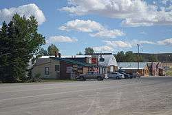
Dupuyer (/dəpuːˈjər/)[4] is a census-designated place and unincorporated community in Pondera County, Montana, United States. Its population was 86 as of the 2010 census.[2] The community is located along U.S. Route 89 and Dupuyer Creek. Dupuyer has a post office with ZIP code 59432.[5][6]
Climate
According to the Köppen Climate Classification system, Dupuyer has a semi-arid climate, abbreviated "BSk" on climate maps.[7]
References
- ↑ "US Gazetteer files: 2010, 2000, and 1990". United States Census Bureau. 2011-02-12. Retrieved 2011-04-23.
- 1 2 "American FactFinder". United States Census Bureau. Archived from the original on 2013-09-11. Retrieved 2011-05-14.
- ↑ "Dupuyer". Geographic Names Information System. United States Geological Survey.
- ↑ Wilson, Kurt (15 September 2015). "The Montana pronunciation guide". Billings Gazette. Retrieved 11 August 2018.
- ↑ United States Postal Service (2012). "USPS - Look Up a ZIP Code". Retrieved 2012-02-15.
- ↑ "Postmaster Finder - Post Offices by ZIP Code". United States Postal Service. Retrieved August 1, 2013.
- ↑ Climate Summary for Dupuyer, Montana
Municipalities and communities of Pondera County, Montana, United States | ||
|---|---|---|
| City | 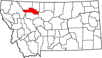 | |
| Town | ||
| CDPs | ||
| Unincorporated community | ||
| Indian reservation | ||
| Footnotes | ‡This populated place also has portions in an adjacent county or counties | |
This article is issued from
Wikipedia.
The text is licensed under Creative Commons - Attribution - Sharealike.
Additional terms may apply for the media files.