Geyser, Montana
| Geyser, Montana | |
|---|---|
| Census-designated place | |
 Geyser  Geyser | |
| Coordinates: 47°15′33″N 110°29′36″W / 47.25917°N 110.49333°WCoordinates: 47°15′33″N 110°29′36″W / 47.25917°N 110.49333°W[1] | |
| County | Judith Basin County, Montana |
| Area | |
| • Total | 0.89 sq mi (2.31 km2) |
| • Land | 0.89 sq mi (2.31 km2) |
| • Water | 0.0 sq mi (0.0 km2) |
| Elevation | 4,186 ft (1,276 m) |
| Population (2010) | |
| • Total | 87 |
| • Density | 98/sq mi (37.7/km2) |
| ZIP Code | 59447 |
| Area code(s) | 406 |
| FIPS code | 30-30550 |
| GNIS feature ID | 0771749 |
Geyser is an unincorporated community and census-designated place (CDP) in Judith Basin County, Montana, United States, southeast of Great Falls along U.S. Route 87. As of the 2010 census it had a population of 87.[2]
The town's name originated from the mud springs in the area the town was first founded. Geyser was moved to its present location with the construction of the Great Northern rail line between Great Falls and Billings.[3]
Geography
Geyser is in northwestern Judith Basin County in a broad valley between the Highwood Mountains to the north and the Little Belt Mountains to the south. U.S. Route 87 runs along the south edge of the community, leading 46 miles (74 km) northwest to Great Falls and 15 miles (24 km) southeast to Stanford, the Judith Basin county seat.
According to the U.S. Census Bureau, the Geyser CDP has an area of 0.89 square miles (2.3 km2), all of it recorded as land.[2] The community sits on a low bench between McCarthy Creek to the east and Crow Coulee to the west. The two creeks flow north to Hay Creek, a tributary of Arrow Creek, which flows northeast to the Missouri River.
Demographics
As of the 2010 census, Geyser's population was 505 people making it 25% larger than the county seat of Stanford and accounting for one quarter of the population of Judith Basin County. The average household size is 2.8 people.
The racial makeup of the town was 96.8% White, 0.2% Native American, and 2.3% from two or more races. Hispanic or Latino of any race were 0.7% of the population.
References
- ↑ "Geyser, Montana". Geographic Names Information System. United States Geological Survey.
- 1 2 "Geographic Identifiers: 2010 Census Summary File 1 (G001): Geyser CDP, Montana". American Factfinder. U.S. Census Bureau. Retrieved August 22, 2018.
- ↑ "Geyser - Central Montana". centralmontana.com. Retrieved 2017-01-22.
Municipalities and communities of Judith Basin County, Montana, United States | ||
|---|---|---|
| City | 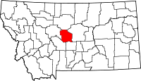 | |
| Town | ||
| CDP | ||
| Other unincorporated communities | ||
| Ghost town | ||