Montana Highway 78
| ||||
|---|---|---|---|---|
| Route information | ||||
| Maintained by MDT | ||||
| Length | 47.714 mi[1] (76.788 km) | |||
| Major junctions | ||||
| South end |
| |||
| North end |
| |||
| Location | ||||
| Counties | Carbon, Stillwater | |||
| Highway system | ||||
| ||||

Montana Highway 78 in the U.S. state of Montana is a state highway running in a northerly direction from an intersection with U.S. Route 212 (US 212) at the city of Red Lodge. It runs through Roscoe and Absarokee. The highway extends about 49 miles (79 km) to a northern terminus at the town of Columbus.[2]
History
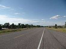
Montana Highway 78 northbound
Before receiving its present designation, Highway 81 was designated as Montana Secondary Highway 307.
Major intersections
| County | Location | mi[1] | km | Destinations | Notes |
|---|---|---|---|---|---|
| Carbon | Red Lodge | 0.000 | 0.000 | Roundabout | |
| Stillwater | Columbus | 47.714 | 76.788 | ||
| 1.000 mi = 1.609 km; 1.000 km = 0.621 mi | |||||
See also

References
- 1 2 Montana Department of Transportation (2013). "Montana Road Log" (PDF). Helena: Montana Department of Transportation. Retrieved March 10, 2017.
- ↑ Official 2007-2008 Montana Highway Travel Map (PDF) (Map). Montana Department of Transportation. Retrieved 2007-12-08.
External links
![]()
This article is issued from
Wikipedia.
The text is licensed under Creative Commons - Attribution - Sharealike.
Additional terms may apply for the media files.