Montana Highway 200
| ||||
|---|---|---|---|---|
 | ||||
| Route information | ||||
| Maintained by MDT | ||||
| Length | 706.272 mi[1] (1,136.635 km) | |||
| Existed | October 1967[2] – present | |||
| Major junctions | ||||
| West end |
| |||
|
| ||||
| East end |
| |||
| Location | ||||
| Counties | Richland, Dawson, McCone, Garfield, Petroleum, Fergus, Judith Basin, Cascade, Lewis and Clark, Powell, Missoula, Lake, Sanders | |||
| Highway system | ||||
| ||||

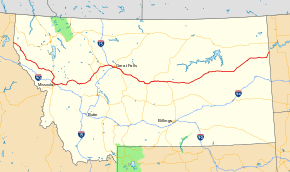
Montana Highway 200 (MT 200) in the U.S. state of Montana is a route running east-west covering the entire state of Montana. From the starting point at ID 200, near Heron, Montana the highway runs east to ND 200 near Fairview, Montana. It is part of a chain of state highways numbered 200 which extend from Idaho across Montana, North Dakota and Minnesota. Montana Highway 200 is also the longest route signed as a state highway in the United States.
Highway 200 helps to connect many small towns located in central Montana and the vast plains area of eastern Montana, to larger western Montana cities such as Great Falls and Missoula.
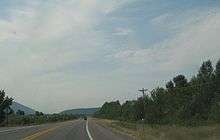
The highway runs parallel to the Blackfoot River from McNamara to Milltown. The highway is subject to hazardous driving conditions in the winter, particularly due to black ice. The road crosses Rogers Pass on the continental divide on its way west to Missoula.
At its western end, west of Missoula, Highway 200 follows the Clark Fork River eastward at the feet of the Cabinet Mountains until it meets the Flathead River at MT 135. It then follows the Flathead River east to Dixon where the Flathead River turns north. Highway 200 continues east following the Jocko River until it intersects with US 93 at Ravalli. The highway then bends south to join I-90 going east into Missoula.
History
Today's Highway 200 is part of a four-state chain of such routes, but it did not begin that way. It was assembled from other state and federal routes over the years.
The status of the routes and route segments that became Highway 200 in 1937.[3]
- The section from the Idaho line to Ravalli was the original MT 3.
- No concurrency from Ravalli to Missoula on US 93 or US 10.
- The section from Bonner to Sun River was then MT 20, and much was yet to be constructed. The route even followed segments of today's MT 21 to Augusta and future US 287 (then MT 33).
- No concurrency from Sun River to Grass Range along US 87.
- The section from Grass Range to Circle was part of the original MT 18.
- The remainder of MT 18 ran from Circle to Glendive, today's MT 200S.
- The section from Circle to Sidney was Montana 23, ending at then MT 14.
- MT 14 ran the rest of the way to Fairview.
By 1941, US 10 Alternate (US 10A) had replaced MT 3 as part of an alternate route from Wye to Spokane via Sandpoint and was now concurrent with US 93 to US 10.
Between 1948 and 1959, many construction projects and route redesignations with concurrencies made MT 20 from Bonner to Sidney the baseline for today's MT 200. MT 23N replaced MT 14 from Sidney to Fairview and MT 20S replaced MT 18 from Circle to Glendive.
In 1960, MT 20 picked up the Sidney to Fairview segment.
By 1969, the entire MT 20 had become MT 200 and included the former US 10A from Idaho to Wye, and following US 10 and 93 through Missoula. MT 20S became 200S.
Major intersections
| County | Location | mi | km | Destinations | Notes |
|---|---|---|---|---|---|
| Sanders | | 0.000 | 0.000 | Continuation into Idaho | |
| | 10.418 | 16.766 | |||
| | 49.102 | 79.022 | Forest Highway 7, seasonal access to Thompson Pass (S-471) and Cooper Pass (FR-7623, Prospect Creek Road) | ||
| | 56.013 | 90.144 | |||
| | 76.706 | 123.446 | |||
| | 85.030 | 136.843 | |||
| Perma | 95.617 | 153.881 | |||
| Dixon | 109.750 | 176.626 | |||
| Lake | Ravalli | 115.787 | 186.341 | West end of US 93 overlap | |
| | |||||
| Missoula | | ||||
| Wye | 143.004 | 230.143 | West end of I-90 overlap; MT 200 west follows exit 96 | ||
| | 146.612 | 235.949 | Airway Boulevard | I-90 exit 99 | |
| Missoula | 148.388 | 238.807 | East end of US 93 overlap; I-90 exit 101 | ||
| 151.451 | 243.737 | Orange Street | I-90 exit 104 | ||
| 152.315 | 245.127 | West end of US 12 overlap; I-90 exit 105 | |||
| East Missoula | 153.940 | 247.742 | East Missoula | I-90 exit 107 | |
| West Riverside | 156.885 | 252.482 | East end of I-90 / US 12 overlap; MT 200 east follows exit 109 | ||
| Bonner | |||||
| Clearwater Junction | 189.465 | 304.914 | |||
| Powell | | 213.308 | 343.286 | ||
| Lewis and Clark | | ||||
| Rogers Pass | 248 | 399 | Continental Divide (elevation 5,610 ft or 1,710 m) | ||
| | |||||
| Bowman's Corner | 266.655 | 429.140 | |||
| Cascade | Simms | ||||
| Sun River | 297.069 | 478.086 | West end of US 89 overlap | ||
| Vaughn | 305.044 | 490.921 | West end of I-15 overlap; MT 200 west follows exit 290 | ||
| | 309.142 | 497.516 | Manchester | I-15 exit 286 | |
| | 313.020 | 503.757 | Eastbound exit and westbound entrance; I-15 exit 282 | ||
| Great Falls | 314.999 | 506.942 | I-15 exit 280 | ||
| 316.588 | 509.499 | East end of I-15 overlap; west end of I-315 / MT 3 overlap; MT 200 east follows exit 278 | |||
| 316.923 | 510.038 | 14th Street Southwest | I-315 exit 0 | ||
| 317.416 | 510.832 | Fox Farm Road / 6th Street Southwest | East end of I-315 overlap | ||
| west end of I-15 Bus. overlap | |||||
| 319.582– 319.662 | 514.317– 514.446 | West end of US 87 overlap | |||
| | 322.762 | 519.435 | |||
| | |||||
| | |||||
| Armington Junction | 342.240 | 550.782 | East end of US 89 overlap | ||
| Judith Basin | | ||||
| Geyser | |||||
| | 378.939 | 609.843 | |||
| | |||||
| | |||||
| Moccasin | |||||
| | |||||
| Fergus | Eddies Corner | 406.937 | 654.902 | East end of MT 3 overlap; west end of US 191 overlap | |
| | 421.272 | 677.972 | |||
| Lewistown | |||||
| west end of US 191 Bus. overlap | |||||
| east end of US 191 Bus. overlap | |||||
| | 454.798 | 731.926 | East end of US 87 overlap | ||
| Petroleum | Winnett | ||||
| | |||||
| Garfield | | 552.525 | 889.203 | ||
| Jordan | |||||
| | |||||
| Garfield–McCone county line | Flowing Well | 588.970 | 947.855 | ||
| McCone | | ||||
| | |||||
| Circle | |||||
| 620.305 | 998.284 | ||||
| | 621.349 | 999.964 | |||
| Dawson | Richey | ||||
| Richland | | 692.396 | 1,114.303 | West end of MT 16 overlap | |
| Sidney | 694.964 | 1,118.436 | East end of MT 16 overlap | ||
| Fairview | |||||
| | 706.624 | 1,137.201 | Continuation into North Dakota | ||
1.000 mi = 1.609 km; 1.000 km = 0.621 mi
| |||||
Related route
| |
|---|---|
| Location | Circle–Glendive |
| Length | 48.674 mi[1] (78.333 km) |
| Existed | 1967[4]–present |
Montana Highway 200S (MT 200S) is a spur route of MT 200 that branches off of the main route near Circle and ends at I-94 in Glendive.
MT 200S was originally part of MT 18, renamed MT 20S when MT 23 from Circle to Sidney was renamed MT 20, and received its current name when MT 20 was renamed MT 200.[4]
In the state road log, MT 200S picks up the mileposts from route N-57 (C000057) from mileposts 279.109 to 327.783, for a total of 48.674 miles (78.333 km).
See also

References
- 1 2 Staff (2013). "Montana Road Log" (PDF). Montana Department of Transportation. Retrieved May 1, 2017.
- ↑ "New Map Changes Route 20". The Havre Daily News. October 18, 1967. p. 4. Retrieved June 19, 2018 – via Newspapers.com.

- ↑ Texaco; Rand McNally and Company (1937). Road map: Idaho, Mont., Wyo (Map). Chicago: Rand McNally and Company. Retrieved April 28, 2017 – via David Rumsey Map Library.
- 1 2 "Highway Route Number Changed". The Billings Gazette. October 2, 1967. p. 27. Retrieved June 19, 2018 – via Newspapers.com.
External links
| Wikimedia Commons has media related to Montana Highway 200. |
Route map: