Light rail in Canada
There are light rail systems in three Canadian urban centres—Calgary, Edmonton, and Ottawa—and one streetcar system in Toronto.[1] Light rail systems are also planned or under construction in Hamilton, Mississauga, Surrey, and Waterloo Region.
Existing light rail systems
The following table lists average weekday ridership figures for the four Canadian light rail systems, using third quarter 2016 figures wherever possible:[2]
| City | System | Transit mode | Avg. weekday ridership[2] |
Opened | Stations | System length |
|---|---|---|---|---|---|---|
| Calgary, Alberta | CTrain | Light rail | 293,400 | 1981[3] | 45[4] | 59.9 km (37.2 mi)[4] |
| Edmonton, Alberta | Edmonton LRT | Light rail | 108,690[5] | 1978[6] | 18[6] | 24.3 km (15.1 mi)[6] |
| Ottawa, Ontario | O-Train | Light rail | 18,600 | 2001 | 5 | 8 km (5.0 mi) |
| Toronto, Ontario [note 1] | Toronto streetcar | Streetcar | 292,100 | 1861 | 708 stops[7] | 82 km (51 mi) |
- ↑ While the system is included here, the Toronto streetcar system is not a light rail system by definition.
Calgary

Calgary Transit's CTrain network, which started operation in 1981, now has the second highest weekday ridership of any light rail transit system in North America, carrying over 299,000 passengers per weekday in the fourth quarter of 2017. There are 45 stations in operation in the 60-kilometer (37 mi) CTrain light rail system,[4][8] After starting by running on one leg in 1981, the system has expanded and now has four legs radiating out into Calgary's suburbs in different directions. The legs have been organized into two routes (identified as the Red Line and the Blue Line) that connect the four legs via shared tracks in a downtown transit mall. The existing four legs of the system, as built in chronological order, are the South leg (1981), the Northeast leg (1985), the Northwest leg (1987), and the West leg (2012). The segments of the system are:
- Downtown – the transit mall where the Red and Blue lines share common tracks at street level along 7th Avenue South;
- Red Line – the line connects the South and Northwest legs via the downtown transit mall;
- Blue Line – the line connects the Northeast and West legs via the downtown transit mall;
- Green Line – the planned line will add about 40 kilometres (25 mi) and 28 stations to the system by connecting a North leg to a Southeast leg, probably in a tunnel underneath the existing downtown transit mall. Construction on it is expected to start in 2017.[9]
Edmonton
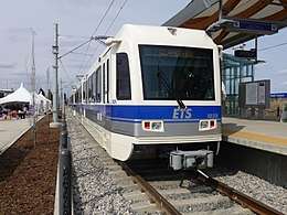
Until 2015, the Edmonton Transit System operated only one light rail line, the Capital Line. In 2015, the new Metro Line became the first new line in Edmonton that is not an extension of the existing Capital Line. The under construction Valley Line will use low-floor vehicles.
- The Capital Line runs roughly north-south, between northeast Edmonton and the Century Park community, with a mix of tunnels and at-grade track. Six stations are underground, while the remaining nine are at-grade.
- The new Metro Line, which opened on September 6, 2015, extended the light rail system by 3.3 km (2.1 mi) and added three new stations. It interlines with the Capital Line, sharing seven stations, and services northwest Edmonton to central Edmonton.[10][11]
- The Valley Line is an under-construction, 27-kilometre (17 mi), low-floor urban line running southeast to west from Mill Woods to Lewis Farms, crossing through downtown. The line will be constructed in two phases, with phase 1 being the portion between Mill Woods and 102 Street stop, which will connect with the Capital and Metro Lines at Churchill.[12][13]
The Government of Alberta has promised $3 billion in light rail transit funding in Alberta over the next 10 years. $1.5 billion of the money will be dedicated to Edmonton's Valley line west and other priorities. Edmonton has started planning and is seeking community feedback on the proposed Centre Line LRT using low floor technology—the same as the Valley Line—which is proposed to connect downtown, the Alberta Legislature, University of Alberta, Whyte Avenue, and to Bonnie Doon Mall on the Valley Line. Renderings have been released for the future expansion of the Capital Line south expansion from Century Park to Ellerslie. This expansion would include a new park-and-ride and operations and maintenance facility. The city will construct the permanent Nait station so the line can support five-car trains. The city is also looking into replacing the crossing at Princess Elizabeth Avenue to ease congestion at the intersection by building an over or under pass. Expansions include a station at Blathford, one of the world's largest fully sustainable communities. And extending the line out to St. Albert, one of Edmonton's larger suburbs. The City of St. Albert has released renderings of what LRT could look like in the city.
Ottawa
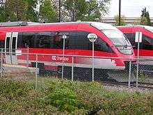
In 2001, to supplement its Bus Rapid Transit (BRT) system, Ottawa opened a diesel light rail pilot project, (the O-Train), which was relatively inexpensive to construct (C$21 million), due to its single-track route along a little used freight-rail right of way and use of diesel multiple units (DMUs) to avoid the cost of building overhead lines along the tracks.
With the construction of the Confederation Line, the O-Train brand has been extended to both rail transit services and the diesel line has been renamed as the Trillium Line.[14]
- The Trillium Line, (Line 2) is an 8 km (5.0 mi) diesel light rail line running north to south from Bayview station to Greenboro station connecting with a transitway at each terminus. There are three passing sidings along the single-track line.
- The Confederation Line, (Line 1) is a light rail line under construction to run east-west from Blair to Tunney's Pasture connecting to a transitway at each terminus and with the Trillium Line at Bayview. The line will run both underground and on the surface. There will be a tunnel downtown with three underground stations.[15] The Confederation Line is currently targeting an opening date in early 2019.
Toronto
_(14918534190).jpg)
While Toronto does not have a light rail system it does operate a streetcar system. Most of the 11 routes of the Toronto streetcar system operate in mixed traffic, but three of them have similarity to light rail in that there is a high degree of separation from road traffic by using partial reserved lanes with some track in tunnels. There is also a proposal to build a fourth such line. The lines are:
- 510 Spadina running between Spadina station and Union station.
- 509 Harbourfront running between Union station and Exhibition Place via Queens Quay station.
- 512 St. Clair running along St. Clair Avenue West between St. Clair station and Gunns Loop via St. Clair West station.
The Toronto Transit Commission is currently constructing its first light rail line, Line 5 Eglinton. When completed it will run across Eglinton Avenue between Mount Dennis (Weston Road) and Kennedy station. This 19-kilometre corridor will include a 10-kilometre underground portion, between Keele Street and Laird Drive.[16] Vehicles will be incompatible with the streetcar system as they will use a different track gauge (1435 mm for LRT, 1495 mm for streetcars).[17]
Proposed
The following table lists light rail lines either planned or under construction:[lower-alpha 1]
| City or region | Line | Construction start | Expected opening | Stations | Line length | Status |
|---|---|---|---|---|---|---|
| Calgary | Green Line (stage 1)[lower-alpha 2] | 2020 | 2026[lower-alpha 3] | 14[lower-alpha 4] | 20 km (12 mi)[lower-alpha 5] | Planned |
| Edmonton | Valley Line Southeast[lower-alpha 6] | 2016[12] | 2020[12] | 12[13] | 13.1 km (8.1 mi)[13] | Under construction[18] |
| Edmonton | Valley Line West | 2019 | 2025[lower-alpha 7] | 16 | 14 km (8.7 mi) | Planned |
| Hamilton | B-Line | 2019 | 2024 | 17 | 13.4 km (8.3 mi) | Planned |
| Ottawa | Confederation Line | 2013 | 2019 | 13 | 12.5 km (7.8 mi) | Under construction |
| Ottawa | Confederation Line (Stage 2) | 2019 | 2022–2023 | 16[lower-alpha 8] | 26.5 km (16.5 mi)[lower-alpha 9] | Planned |
| Ottawa | Trillium Line (Stage 2) | 2019 | 2021 | 8[lower-alpha 10] | 14 km (8.7 mi)[lower-alpha 11] | Planned |
| Peel Region | Hurontario LRT | 2018 | 2022 | 23 | 17.6 km (10.9 mi)[19] | Planned |
| Surrey | Surrey–Newton–Guildford Line | 2019 | 2024 | 11 | 10 km (6.2 mi) | Planned |
| Surrey | Surrey–Langley Line | 2030 | 8 | 17 km (11 mi) | Planned | |
| Toronto | Line 5 Eglinton | 2011 | 2021 | 26 | 19 km (12 mi) | Under construction |
| Toronto | Line 6 Finch West | 2018 | 2023 | 18 | 11 km (6.8 mi) | Planned |
| Toronto | Sheppard East LRT | 2022 | 2028–2032[20] | 26 | 13 km (8.1 mi) | Planned |
| Waterloo Region | Ion rapid transit[lower-alpha 12] | 2014 | 2018[21] | 19[lower-alpha 13] | 19 km (12 mi) | Under construction |
Hamilton
Hamilton, Ontario's B-Line route, part of the region's BLAST rapid transit network, is a proposed light rail line to run east-west along King and Main streets, with McMaster University and Eastgate Square as its termini.[22] However, in announcing the financing for the line, the Province of Ontario changed the eastern terminus to Queenston Circle instead of Eastgate Square but added a branch to the new West Harbour GO Station.[23] After uncertainty in Hamilton's city council, and poor ridership projections in provincially funded studies, Queen's Park announced that they would abandon the spur line down James North, and a previously announced BRT system along James, in favour of reinstating Eastgate Square as the terminal station of the B-Line.[24]
Peel Region
The Hurontario LRT is a proposed 17.6 km (10.9 mi) light rail line largely financed by the Province of Ontario to run on the surface along Hurontario Street from Port Credit GO Station in Mississauga to Steeles Avenue in Brampton. On October 28, 2015, Brampton City Council cancelled the proposed 5.6 km (3.5 mi) section of the line along Main Street in Brampton to Brampton GO Station.[19]
Surrey
A 27-kilometre (17 mi) light rail network consisting of three lines radiating from Skytrain stations has been proposed for construction in Surrey, BC. The planned lines are:[25][26]
- Surrey City Centre to Guildford Town Centre along 104 Avenue (travel time: 10 minutes).
- Surrey City Centre to Newton Town Centre along King George Boulevard (travel time: 15 minutes).
- Surrey City Centre via Fleetwood Town Centre to Langley along the Fraser Highway (travel time: 24.5 minutes).
The lines on 104 Avenue and King George Boulevard would be built in seven years while the Surrey-Langley Line on the Fraser Highway would be finished five years later.[25] A report on the economic benefits of the project was produced by a consulting firm in May 2015.[27]
This project (among others major transit infrastructure initiatives, including the extension of the Millennium Line under Broadway in Vancouver) was originally made contingent, by the governing BC Liberal party, on the approval, by plebiscite in 2015, of a sales tax increase to generate new funds for public transit. The electorate voted against the tax increase, leaving the project unfunded.[28] Subsequently, the project has been included in the second phase of TransLink's 10-Year Investment Plan, which is scheduled for approval in late 2017.[29]
Toronto
There are two additional light rail lines planned in the city of Toronto.
- Line 6 Finch West is a 11-kilometre light rail transit line that will run along the surface of Finch Avenue from the new Finch West subway station on the Toronto–York Spadina Subway Extension at Keele Street to Humber College.[30]
- The Sheppard East LRT is a proposed 13-kilometre light rail transit line that will run along the surface of Sheppard Avenue from Don Mills subway station to east of Morningside Avenue.[31]
Victoria region
In August 2011, Victoria Regional Transit System announced that light rail transit was recommended as the preferred technology to connect Victoria to Saanich and the West Shore communities.[32][33]
Waterloo Region
The Waterloo Region, Ontario has approved plans for a light rail transit system from Waterloo to Cambridge, which will be constructed in two phases.[34] The first phase of the LRT system is under construction and will run from Conestoga Mall in Waterloo to Fairview Park Mall in Kitchener. Extension to Ainslie St. Transit Terminal in Cambridge will be implemented in the second phase. During the first phase, the Kitchener to Cambridge segment will be operated as adapted bus rapid transit. Currently, the iXpress system, a limited stop express bus service, is operating as a precursor to rapid transit. The Region of Waterloo received funding from the provincial government.[35]
See also
Notes
- ↑ Data come from the Wikipedia article for each line unless otherwise noted.
- ↑ Only phase 1 which spans from 16 Avenue N to 126 Avenue SE (About 14 stations and 20km).
- ↑ Depends on delivery of funding promised by federal and provincial governments during recent elections.
- ↑ When fully complete the Green Line will have 28 Stations
- ↑ When Green Line is complete it will be 48km long.
- ↑ Data for Valley Line phase 1 only from Mill Woods to 102 Street.
- ↑ Council is looking into the possibility of opening the line in phases between 2020 and 2025. For example the first parts of the line closer to downtown could open in 2020 while sections near the end of line could open closer to 2025 .
- ↑ When Stage 2 is complete, the Confederation Line will have 29 stations.
- ↑ When Stage 2 is complete, the Confederation Line will be 39 km long.
- ↑ When Stage 2 is complete, the Trillium Line will have 13 stations.
- ↑ When Stage 2 is complete, the Trillium Line will be 22 km long.
- ↑ Data for Ion phase 1 only from Conestoga Mall to Fairview Park Mall.
- ↑ 6 of the 19 Ion stations serve one direction only.
References
- ↑ "Commuting Patterns and Places of Work of Canadians, 2006 Census". Statistics Canada. 2008. Retrieved July 14, 2008.
- 1 2 "Public Transportation Ridership Report Third Quarter 2016" (pdf). American Public Transportation Association. March 13, 2017. pp. 31–32. Retrieved December 28, 2017.
- ↑ "About Calgary Transit / Corporate Information / History". Calgary Transit. City of Calgary. 2015. Retrieved July 17, 2015.
- 1 2 3 "About Calgary Transit / Facts and Figures / Statistics". Calgary Transit. City of Calgary. 2015. Retrieved July 17, 2015.
- ↑ "September 2015 Daily Cumulative Boarding Report Bus & LRT" (PDF). Edmonton. City of Edmonton. September 2015. p. 14. Retrieved May 1, 2016.
- 1 2 3 "LRT for Everyone" (PDF). Edmonton Transit System and City of Edmonton. p. 4. Archived from the original (pdf) on September 10, 2015. Retrieved August 5, 2014.
- ↑ "2012 - TTC Operating Statistics". Toronto Transit Commission. 2013. Retrieved August 4, 2014.
- ↑ "Northwest LRT extension to Rocky Ridge/Tuscany". Calgary Transit. The City of Calgary. 2014. Archived from the original on August 24, 2012. Retrieved August 4, 2014.
- ↑ "Vision for Green Line". Calgary Transit. Retrieved May 2, 2016.
- ↑ "Edmonton's Metro Line now set to open in spring". Retrieved April 12, 2017.
- ↑ Dykstra, Matt (May 9, 2013). "Edmonton city crews promise to finish north extension of LRT line to NAIT by next spring". Edmonton Sun. Retrieved August 26, 2013.
- 1 2 3 "Valley Line (SE to West LRT): Mill Woods to Lewis Farms". Edmonton Transit System. 2015. Archived from the original on May 15, 2015. Retrieved June 16, 2015.
- 1 2 3 "Valley Line LRT Animation". City of Edmonton. December 3, 2013. Retrieved June 16, 2015.
- ↑ "O-Train name approved for Ottawa light rail system". CBC News Network. September 17, 2014. Retrieved December 29, 2014.
- ↑ "Confederation Line". City of Ottawa. 2015. Archived from the original on June 13, 2015. Retrieved June 15, 2015.
- ↑ "What is the Crosstown?". Metrolinx. June 4, 2015. Retrieved June 4, 2015.
- ↑ Steve Munro (July 2, 2013). "An Interminable Debate About Track Gauge". Steve Munro. Retrieved June 4, 2015.
- ↑ "Archived copy". Archived from the original on February 9, 2016. Retrieved June 16, 2015.
- 1 2 "Brampton council votes to reject provincially approved LRT". Metro News. October 28, 2015. Retrieved October 28, 2015.
- ↑ "2018–2022 TTC Corporate Plan" (PDF). TTC.ca. p. 113. Retrieved January 29, 2018.
- ↑ "LRT rollout delayed, Bombardier blamed". Waterloo Region Record. May 24, 2016. Retrieved May 24, 2016.
- ↑ "Rapid Transit". City of Hamilton. Archived from the original on March 25, 2010. Retrieved June 30, 2010.
- ↑ "Hamilton to get a new LRT and GO Train station - Toronto Star". Retrieved April 12, 2017.
- ↑ Van Dongen, Matthew (April 27, 2017). "LRT to Eastgate Square reborn after council nod". Hamilton Spectator. Retrieved May 12, 2017.
- 1 2 "Light Rail Transit". City of Surrey. 2015. Retrieved June 15, 2015.
- ↑ "City of Surrey's Vision for Rapid Transit -- LRT". video. City of Surrey. August 23, 2011. Retrieved June 15, 2015.
- ↑ Shirocca Consulting (2015). "Economic Benefits of Surrey LRT" (PDF). City of Surrey. Retrieved June 15, 2015.
- ↑ Bula, Francis (July 2, 2015). "Vancouver-region tax hike transit referendum voted down by 62 per cent". The Globe and Mail. Retrieved July 2, 2015.
- ↑ "Phase Two of the 10-Year Vision: Preparing for Growth". TransLink. Retrieved March 20, 2017.
- ↑ "Finch West LRT". Metrolinx. June 4, 2015. Retrieved June 4, 2015.
- ↑ "Toronto Light Rail Transit Projects". Metrolinx. June 4, 2015. Retrieved June 4, 2015.
- ↑ "April 2011: Light Rail Recommendation". BC Transit. 2011. Retrieved June 12, 2015.
- ↑ "Regional Transit Local Funding Options - Technical Analysis". BC Transit. August 22, 2012. Retrieved June 12, 2015.
- ↑
Douglas John Bowen (July 12, 2013). "Waterloo opts for Bombardier LRVs". International Railway Journal. Archived from the original on July 13, 2013. Retrieved July 13, 2013.
The first of the Flexity Freedom LRV are due to be delivered in mid-2016, and will be used on the 19km, 16-station line from Conestoga Mall in Waterloo to Fairview Park Mall in Kitchener. The $C 92.4m ($US 89.2m) contract will include an option for 16 additional vehicles.
- ↑ "Province announces funding for rapid transit in Waterloo Region". City of Hamilton. June 29, 2010. Retrieved June 30, 2010.