Saanich, British Columbia
| Saanich W̱SÁNEĆ | ||
|---|---|---|
| District municipality | ||
| The Corporation of the District of Saanich[1] | ||
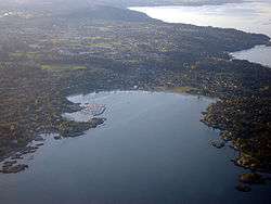 Aerial of Saanich, with Cadboro Bay in the foreground | ||
| ||
 Saanich Location of Saanich within British Columbia | ||
| Coordinates: 48°29′02″N 123°22′52″W / 48.484°N 123.381°W | ||
| Country | Canada | |
| Province | British Columbia | |
| Regional District | Capital | |
| Incorporated | 1906 | |
| Government | ||
| • Mayor | Richard Atwell | |
| • Governing body | Saanich District Council | |
| • MP |
List of MPs
| |
| • MLA |
List of MLAs
| |
| Area[2] | ||
| • Total | 103.78 km2 (40.07 sq mi) | |
| Elevation | 23 m (75 ft) | |
| Population (2016)[2] | ||
| • Total | 114,148 (46th) | |
| • Density | 1,099.9/km2 (2,849/sq mi) | |
| Time zone | UTC−8 (PST) | |
| • Summer (DST) | UTC−7 (PDT) | |
| Postal code span | V8N-V8Z | |
| Area code(s) | 250, 778 & 236 | |
| Website | www.saanich.ca/ | |

The District of Saanich (/ˈsænɪtʃ/) is a district municipality on Vancouver Island in British Columbia, within the Greater Victoria area. The population was 114,148 at the 2016 census, making it the most populous municipality in the Capital Regional District and Vancouver Island, and the eighth-most populous in the province.[3] The district adopted its name after the Saanich First Nation, meaning "emerging land" or "emerging people".[4] The District acts as a bedroom community immediately to the north of Victoria, British Columbia.
With an area of 103.44 square kilometres (39.94 sq mi), it is the largest municipality in Greater Victoria. The municipality contains a wide variety of rural and urban landscapes and neighbourhoods stretching north to the Saanich Peninsula. Saanich is home to part of the University of Victoria which is bisected by the neighbouring district municipality of Oak Bay. The municipality's topography is undulating with many glacially scoured rock outcroppings. Elevations range from sea level to 229 metres (751 ft). The physical setting is greatly influenced by water. There are 8.1749 square kilometres (3.1563 sq mi) of fresh water lakes and 29.61 kilometres (18.40 mi) of marine shoreline.
History
Saanich has been the home to First Nations people for thousands of years. The non-native history begins with the arrival of the Hudson's Bay Company in the 1840s.
The Craigflower Schoolhouse (originally called Maple Point School), the oldest surviving school building in Western Canada, was built on orders from Kenneth MacKenzie. He came from Scotland with his family in 1852, on the Hudson's Bay Company ship Norman Morison, to establish a farm for the Puget Sound Agricultural Company, a subsidiary of the Hudson's Bay Company. A school was needed for the children of farm employees, as well as those of arriving settlers.
The Municipality of Saanich was incorporated on March 1, 1906. The Dominion Astrophysical Observatory telescope was designed by Dr John Stanley Plaskett, astronomer with the Department of the Interior in Ottawa. The 72 inch (1.8 m) reflecting telescope was the largest of its kind in the world when it was built, though this was only the case for a few short months in 1918.
Geography and climate
The District of Saanich contains a long shoreline with sandy beaches located at a number of ocean bays. Two of the beaches are Cadboro Bay Beach and Cordova Bay Beach. Cadboro Bay is known as the home of the "Cadborosaurus", a mythical cryptid. Saanich's notable parks include Mount Douglas Park, Mount Tolmie Park (with viewpoints), and Gyro Park.
| Climate data for Victoria Phyllis Street, British Columbia (1971-2000) | |||||||||||||
|---|---|---|---|---|---|---|---|---|---|---|---|---|---|
| Month | Jan | Feb | Mar | Apr | May | Jun | Jul | Aug | Sep | Oct | Nov | Dec | Year |
| Record high °C (°F) | 14.5 (58.1) |
15.0 (59) |
18.5 (65.3) |
22.0 (71.6) |
27.5 (81.5) |
30.5 (86.9) |
28.5 (83.3) |
29.5 (85.1) |
27.5 (81.5) |
23.0 (73.4) |
16.1 (61) |
15.0 (59) |
30.5 (86.9) |
| Average high °C (°F) | 7.2 (45) |
8.2 (46.8) |
10.2 (50.4) |
12.8 (55) |
15.6 (60.1) |
18.2 (64.8) |
20.1 (68.2) |
20.1 (68.2) |
17.5 (63.5) |
13.2 (55.8) |
9.4 (48.9) |
7.4 (45.3) |
13.3 (56) |
| Daily mean °C (°F) | 5.5 (41.9) |
6.1 (43) |
7.5 (45.5) |
9.5 (49.1) |
11.9 (53.4) |
14.2 (57.6) |
15.7 (60.3) |
15.8 (60.4) |
13.9 (57) |
10.6 (51.1) |
7.5 (45.5) |
5.7 (42.3) |
10.3 (50.6) |
| Average low °C (°F) | 3.7 (38.7) |
4.0 (39.2) |
4.8 (40.6) |
6.2 (43.2) |
8.1 (46.6) |
10.1 (50.2) |
11.3 (52.3) |
11.4 (52.5) |
10.1 (50.2) |
8.0 (46.4) |
5.6 (42.1) |
4.0 (39.2) |
7.3 (45.1) |
| Record low °C (°F) | −8.0 (17.6) |
−11.0 (12.2) |
−4.0 (24.8) |
0.6 (33.1) |
3.0 (37.4) |
5.6 (42.1) |
8.0 (46.4) |
7.0 (44.6) |
5.0 (41) |
−2.0 (28.4) |
−10.5 (13.1) |
−10.0 (14) |
−11 (12.2) |
| Average precipitation mm (inches) | 102.2 (4.024) |
76.7 (3.02) |
51.5 (2.028) |
36.1 (1.421) |
34.2 (1.346) |
25.5 (1.004) |
16.1 (0.634) |
23.8 (0.937) |
25.9 (1.02) |
66.9 (2.634) |
130.8 (5.15) |
109.2 (4.299) |
698.9 (27.517) |
| Average rainfall mm (inches) | 99.4 (3.913) |
72.7 (2.862) |
50.9 (2.004) |
36.1 (1.421) |
34.2 (1.346) |
25.5 (1.004) |
16.1 (0.634) |
23.8 (0.937) |
25.9 (1.02) |
66.7 (2.626) |
129.0 (5.079) |
105.8 (4.165) |
686.1 (27.011) |
| Average snowfall cm (inches) | 2.8 (1.1) |
4.0 (1.57) |
0.2 (0.08) |
0.0 (0) |
0.0 (0) |
0.0 (0) |
0.0 (0) |
0.0 (0) |
0.0 (0) |
0.2 (0.08) |
1.9 (0.75) |
3.4 (1.34) |
12.5 (4.92) |
| Average precipitation days (≥ 0.2 mm) | 17.0 | 15.2 | 15.0 | 12.2 | 10.9 | 8.9 | 6.1 | 5.9 | 7.3 | 13.6 | 19.0 | 18.3 | 149.4 |
| Average rainy days (≥ 0.2 mm) | 16.7 | 14.9 | 15.0 | 12.2 | 10.9 | 8.9 | 6.1 | 5.9 | 7.3 | 13.6 | 18.8 | 17.7 | 148 |
| Average snowy days (≥ 0.2 cm) | 0.88 | 1.0 | 0.11 | 0.0 | 0.0 | 0.0 | 0.0 | 0.0 | 0.0 | 0.07 | 0.39 | 0.96 | 3.41 |
| Source: Environment Canada[5] | |||||||||||||
Government
The Saanich District Council is the governing body of the municipality of Saanich. The council consists of the mayor and eight councillors.
- Mayor: Richard Atwell
- Councillors: Susan Brice, Judy Brownoff, Karen Harper, Fred Haynes, Dean Murdock, Colin Plant, Vicki Sanders, Leif Wergeland[6]
Neighbourhoods
Saanich is divided into twelve Local Areas for planning purposes.[7] In addition, there are a number of community associations in the municipality that represent neighbourhoods largely overlapping with the Local Areas.[8] The Local Areas, and representative community associations, are listed below:
- Blenkinsop. A primarily rural community in a valley situated west of Mount Douglas. Represented by the Blenkinsop Valley Community Association.
- Cadboro Bay. A small village located at the eastern edge of Saanich, bordering on Oak Bay near the University of Victoria. The community also includes the upscale waterfront neighbourhood of Ten Mile Point. Represented by the Cadboro Bay Residents' Association.
- Carey. A suburban community located in western Saanich. Represented by the Residents Association of Strawberry Vale, Marigold and Glanford in the north, and the Mount View Colquitz Community Association in the south.
- Cordova Bay. A seaside community in northern Saanich. Represented by the Cordova Bay Association for Community Affairs.
- Gordon Head. A large suburban community to the north of the University of Victoria. Represented by the Gordon Head Residents' Association.
- North Quadra. A suburban community in the centre of the municipality. Represented by the North Quadra Community Association.
- Quadra. A large urban and suburban community surrounding the urban core of Saanich. Contains the Cedar Hill Golf Course and is represented by the Quadra Cedar Hill Community Association.
- Royal Oak. A suburban community at the rural edge of Saanich. Represented by the Royal Oak Community Association, Falaise Community Association, and the Broadmead Area Residents' Association.
- Rural Saanich. The largest Local Area by area, this part of Saanich is sparsely populated and mostly rural. Represented in part by the Prospect Lake and District Community Association.
- Saanich Core. The urban centre of the District of Saanich. Contains Uptown and the municipal hall. Represented by part of the Mount View Community Association and part of the Quadra Cedar Hill Community Association.
- Shelbourne. An urban and suburban community stretching between the City of Victoria and the University of Victoria. Represented by the Mount Tolmie Community Association and Camosun Community Association.
- Tillicum. An urban and suburban community along the Gorge in western Saanich. Represented by the Gorge Tillicum Community Association.
Education
The northeastern half of British Columbia's third largest university, the University of Victoria campus, is in Saanich, while the southwestern portion is in neighbouring Oak Bay. Saanich is also home to both major campuses of Camosun College, the original Lansdowne campus, and the Interurban campus.
Saanich is divided between two bordering school districts, School District 61 Greater Victoria and School District 63 Saanich. It is also the home of South Island Distance Education School.
Demographics
As of 2016, the District of Saanich has a population of 114,148.[9] This corresponds to a 4.0% increase since 2011. The total number of occupied dwellings is 46,652 with an average of 2.4 persons per household. With a land area of 103.78 km2 (40.07 sq mi), Saanich possesses a population density of 1,099.9 per square kilometre.
Surrounding municipalities and communities
Places adjacent to Saanich, British Columbia | |
|---|---|
References
- ↑ "British Columbia Regional Districts, Municipalities, Corporate Name, Date of Incorporation and Postal Address" (XLS). British Columbia Ministry of Communities, Sport and Cultural Development. Retrieved November 2, 2014.
- 1 2 "Saanich, District municipality [Census subdivision], British Columbia and Capital, Regional district [Census division], British Columbia". Statistics Canada. January 23, 2017. Retrieved February 8, 2017.
- ↑
- ↑ Elliott, John. "SENĆOŦEN Community Portal". www.firstvoices.ca. Retrieved April 10, 2018.
- ↑ "Canadian Climate Normals 1971-2000". Government of Canada. Retrieved 19 May 2016.
- ↑ "District of Saanich Council". District of Saanich. Retrieved 16 September 2018.
- ↑ "Local Area Plans". Saanich. District of Saanich. Retrieved 9 July 2017.
- ↑ "Community Associations". Saanich. District of Saanich. Retrieved 9 July 2017.
- ↑ "Census Profile, 2016 Census". 2016 Census. Statistics Canada.
External links
| Wikimedia Commons has media related to Saanich, British Columbia. |
| Subdivisions |  | |
|---|---|---|
| Communities | ||
| Metro areas and agglomerations | ||
| District municipalities |
| |
| ||