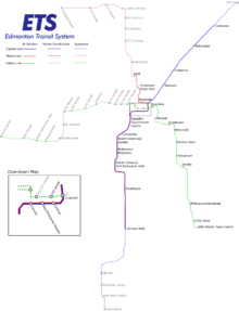
Capital Line
| Capital Line | |||
|---|---|---|---|
 Capital Line crossing the North Saskatchewan River | |||
| Overview | |||
| Type | Light rail | ||
| Locale | Edmonton | ||
| Termini |
Clareview Century Park | ||
| Stations | 15 | ||
| Operation | |||
| Opened | April 22, 1978 | ||
| Operator(s) | Edmonton Transit System | ||
| Character | Surface line outside of city centre, subway style line under downtown and the UofA. | ||
| Depot(s) | D.L. MacDonald Yard | ||
| Technical | |||
| Line length | 21 km (13.0 mi) | ||
| Number of tracks | 2 | ||
| Track gauge | 1,435 mm (4 ft 8 1⁄2 in) | ||
| Operating speed | 80 kilometres per hour (50 mph) maximum[1] | ||
| |||

The Edmonton LRT Capital Line is a light rail transit line running from northeast Edmonton to the south. Operated by the Edmonton Transit System, the line provides access to Downtown Edmonton and the University of Alberta. The Capital Line currently consists of fifteen stations, six of which are underground. Seven stations are shared with the Metro Line.
History
On April 22, 1978 the line opened between Belvedere and Central stations. At the time (and for another 37 years) the system consisted solely of the single line. It was not named the Capital Line until 2012 when expansion plans were revealed for additional lines.[2]
The 1980s were a decade of expansion for the Capital Line. It expanded northwards toward Clareview in 1981, and westwards toward Bay and Corona, under the downtown core in 1983. Another underground extension was completed in 1989 with the opening of Grandin Station.
One station opened in the 1990s, University, in August 1992. The underground station was connected to the downtown leg by the Dudley B. Menzies Bridge.
During the 2000s, under the mayorship of Stephen Mandel, the Capital Line was expanded southward. Health Sciences opened in 2006, the first new station in 14 years. In 2009, McKernan/Belgravia and South Campus opened, followed by Southgate and Century Park in 2010.
After the completion of the south leg of the Capital Line, city council shifted their efforts towards the new Metro Line.
Future
South expansion
In January 2008, Mayor Stephen Mandel announced that the southern leg will be extended further south along 111 Street to Anthony Henday Drive, and then west to 127 Street SW. There will be a station and a 1,100-car Park and Ride between 127 Street and 135 Street at Ellerslie Road. A new LRT maintenance facility will also be built as part of the extension. Eventually, the LRT will continue south for another stop at 41 Avenue SW. City council approved the route to the Ellerslie Station, and for construction to begin on the Park and Ride in July 2009.[3] Although not yet approved by City Council, there is a potential for an additional station at Twin Brooks between 9 and 12 Avenues on the west side of 111 Street. Construction of Heritage Valley Park and Ride began in May 2018, and is expected to be complete by the end of 2019. The Transit Centre will be used to provide shuttle service to and from Century Park Transit Centre until the Capital Line LRT is extended to Ellerslie Road. In June 2017, additional preliminary engineering from Century Park to Ellerslie Road was started to review and refresh the 2010 preliminary design, bring the project up to current standards and relefct the principles of Urban LRT. This work is scheduled to be complete in the fall of 2018 and will look at the feasibility of adding a station adjacent to Twin Brooks and the potential for crossings to be raised or lowered, from street level, at 9 and 12 Avenues on 111 Street, and at Ellerslie Road. Integration of the stations into the adjacent communities, with respect to aesthetics and materials, is also being reviewed.
Capital Line South continues to be high floor LRT and is 4.5 km long and includes:[4]
- An underpass at 23 Avenue, bridges crossing Blackmud Creek and Anthony Henday Drive
- An operations and maintenance facility south of Anthony Henday Drive
- A combined LRT station, transit centre, and Heritage Valley Park and Ride facility on Ellerslie Road, between 127 Street and 135 Street
The City of Edmonton is also looking into extending the line even further, adding 3 additional stations; Provincial Lands, Heritage Valley and Desrochers (these three stations names, along with Ellerslie station are placeholders and may change once the stations are built). In 2017, the Government of Alberta announced that a new state of the art hospital would be built near the corner of Ellerslie Road and 127 Street SW.[5] There is currently no timeline or funding for the Capital Line LRT extension to Heritage Valley Park and Ride. There are no current plans for an extension to the Edmonton International Airport and Leduc. In late April 2012, the city launched bus route 747 from Century Park Station to the airport.[6]
Northeast expansion
In 2008, Edmonton City Council approved a plan to extend the Capital Line northeast by one station to Gorman Towne Centre.[7] On April 30, 2009, Mayor Stephen Mandel announced a $210 million project to extend the LRT system to a new Gorman Station. The expansion beyond Clareview Station was planned to continue along the CN right-of-way to a station and park-and-ride north of 153 Avenue and Victoria Trail. The plan would have received funding from three levels of government. However, funding was shifted to the Metro Line in July 2009 as city officials saw that line as a higher priority for the city. The city has not ruled out a near-future extension to Gorman.[8] The City completed preliminary engineering on this project in 2010, however there is no budget or timeline for design and construction.[9]
From a land use planning perspective, the City of Edmonton has approved two area structure plans beyond Gorman and Anthony Henday Drive[10] that depict different alignments for further LRT extension into Edmonton's far northeast. Adopted in 2010, the Edmonton Energy and Technology Park Area Structure Plan depicts extension of the LRT along 50 Street across Manning Drive to the north, and then generally paralleling Manning Drive to approximately Highway 28A.[11] This ASP qualifies that this "is a potential alignment only, and will be updated to reflect the completed planning for the Northeast LRT when a final route is determined."[11]
Adopted in 2013, the Horse Hill ASP depicts extension of the LRT along 50 Street to the north, and then northeast along Fort Road to Meridian Street before crossing Manning Drive in a northwesterly direction into the Edmonton Energy and Technology Park.[12] This ASP qualifies that "extension of LRT service will be subject to LRT system planning and design, as well as the availability of funding" and that the alignment it depicts "is preliminary and subject to change."[12]
The Capital Line Northeast is part of the Transportation Master Plan's vision to expand LRT service to all sectors of the City by 2040. Preliminary engineering for an LRT extension north of Clareview station was completed in 2010. The City will move forward to design and construction once funding becomes available.
The preliminary engineering project ends at a future station in the Gorman area, north of 153 Avenue and east of the CN tracks.
The project includes:[13]
- A 2.9 km extension north of Clareview station, primarily within the existing CN right-of-way
- LRT station at Gorman, north of 153 Avenue
- Multi-use trail from Clareview station to 151 Avenue, with provision for future connections to adjacent park areas
- Street-level LRT crossings at 144 Avenue and 153 Avenue
Stations
Future stations
|
|
References
- ↑ "SD160 Light Rail Vehicle" (PDF). Siemens. Archived from the original (PDF) on 29 September 2012. Retrieved 2 February 2011.
- ↑ Hoang, Linda (January 31, 2013). "City announces five new LRT line names including 'Energy Line,' 'Capital Line'". CTV News Edmonton. Retrieved June 27, 2016.
- ↑ "South LRT Extension" (PDF). City of Edmonton. July 2009. Archived from the original (PDF) on 2011-06-16. Retrieved 2010-04-24.
- ↑ [edmonton.ca/capitalsw "Capital Line South"] Check
|url=value (help). City of Edmonton. - ↑ Ehrkamp, Laura. "New state-of-the-art hospital for south Edmonton". Government of Alberta. Retrieved August 9, 2018.
- ↑ "Edmonton International Airport Service". City of Edmonton. Archived from the original on October 7, 2012. Retrieved May 27, 2012.
- ↑ City of Edmonton - Northeast to Gorman LRT Archived 2012-08-19 at the Wayback Machine.
- ↑ "NAIT LRT line a go after feds approve funding: report". Edmonton Journal. 2009-07-02. Archived from the original on July 5, 2009. Retrieved 2009-09-05.
- ↑ "Northeast LRT to Gorman". City of Edmonton. Archived from the original on August 19, 2012. Retrieved May 27, 2012.
- ↑ "Plans in Effect" (PDF). City of Edmonton. May 2013. Archived from the original (PDF) on October 17, 2013. Retrieved October 16, 2013.
- 1 2 "Edmonton Energy and Technology Park Area Structure Plan (Office Consolidation)" (PDF) (PDF). City of Edmonton. May 2011. pp. 66–67 (PDF pages 69–70). Retrieved October 16, 2013.
- 1 2 "Horse Hill Area Structure Plan (Office Consolidation)" (PDF) (PDF). City of Edmonton. July 2013. pp. 34 & 54 (PDF page 38 & 58). Archived from the original (PDF) on October 17, 2013. Retrieved October 16, 2013.
- ↑ "Capital Line Northeast". City of Edmonton. Retrieved August 9, 2018.
External links
Edmonton Transit System LRT stations | |||
|---|---|---|---|
| Capital Line | |||
| Metro Line |
| ||
| Valley Line (2020) | |||
Edmonton portal | |||