Gunns Loop
Gunns Loop | |||||||||||
|---|---|---|---|---|---|---|---|---|---|---|---|
 | |||||||||||
| Location |
St. Clair Avenue West Toronto, Ontario Canada | ||||||||||
| Coordinates | 43°40′19″N 79°28′17″W / 43.67194°N 79.47139°WCoordinates: 43°40′19″N 79°28′17″W / 43.67194°N 79.47139°W | ||||||||||
| Owned by | Toronto Transit Commission | ||||||||||
| Platforms | 2 - separate area for buses and streetcars | ||||||||||
| Tracks | 1 | ||||||||||
| Connections |
| ||||||||||
| Construction | |||||||||||
| Structure type | Small service building for staff washroom | ||||||||||
| History | |||||||||||
| Opened | 27 July 1981[1] | ||||||||||
| Services | |||||||||||
| |||||||||||
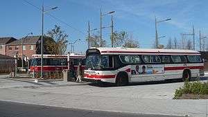
Gunns Loop is a station and turning loop at the western terminus of the 512 St. Clair streetcar line of the Toronto Transit Commission (TTC). It is located at the northwest corner of St. Clair Avenue West and Gunns Road, a block west of Keele Street,[1] in Toronto.
History
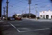
Prior to construction of the dedicated right-of-way, the terminus of the 512 St. Clair route had been at the Keele Loop, just north of St. Clair Avenue where Weston Road merges with Keele Street.[2]
The loop is named for nearby Gunns Road, which in turn is named after Gunns Limited, a West Toronto abbatoir founded by Donald Gunn[3]
The old loop was closed and service began to the new loop in 1981.[1] Signs on westbound 512 St. Clair streetcars still indicate Keele as the destination, when they are actually coming to Gunns.[4]
Services
A small building provides washroom facilities for TTC operators. There is a platform and upgraded new design shelter[5] for people waiting for streetcars,[4] while bus passengers have a regular bus shelter.
As well as being the terminus for the 512 St. Clair streetcar,[6] the loop is the easterly terminus of bus route 71A Runnymede which provides service farther west along St. Clair Avenue and down to Runnymede Station.[7]
References
- 1 2 3 James Bow. "St. Clair Carries On Alone". Transit Toronto. Retrieved July 1, 2014.
On Monday, July 27, 1981, the old Keele Loop was closed, and service began on an additional 1100 feet of double track laid down further west to the new loop on Maybank (now called Gunns) Avenue.
- ↑ James Bow. "A History of the Rogers/Weston Streetcar Loops". Transit Toronto. Retrieved July 1, 2014.
Service on St. Clair Avenue continued to push west, crossing the Newmarket and Weston Subs via underpasses in the mid 1920s and terminating at Keele Loop, located just off of Keele Street just north of St. Clair Avenue.
- ↑ http://www.trainweb.org/oldtimetrains/stockyards/stock.htm
- 1 2 A. Rozumek (25 March 2012). "Transformation at the End of the Line: Placemaking at Gunns Loop". West Toronto. Retrieved July 1, 2014.
Through functional and beautiful design, Gunns Loop now has a strong sense of place appropriate for the western terminus of a line in Toronto’s iconic streetcar network.
- ↑ "TRANSIT CITY IMPLEMENTATION – THE ST. CLAIR PROJECT EXPERIENCE" (PDF). Toronto Transit Commission. Retrieved September 1, 2014.
Enhanced streetscape and urban design features including streetcar shelters, platforms, and public art.
- ↑ TTC route 512 St. Clair
- ↑ TTC route 71 Runnymede
External links
![]()
- Extend the 512 Streetcar to Jane Street
- "New Addition to Gunn's Loop". Councillor Frances Nunziata. 8 October 2013.
Today the TTC completed the installation of a new sign at Gunn’s Loop identifying the St. Clair West Village Area. This sign was requested back when the loop was under construction and I am pleased to see that it has finally been installed.