Confederation Line
| Line 1 (Confederation Line) | ||||||||||||||||||||||||||||||||||||||||||||||||||||||||||||||||||||||||||||||||||||||||||||||||||||||||||||||||||||||||||||||||||||||||||||||||||||||||||||||||||||||||||||||||||||||||||||||||||||||||||||||||||||||||||||||||||||||||||||||||||||||||||||||||||||||||||||||||||||||||||||||||||||||||||||||||||||||||||||||||||||||||||||||||||||||||||||||||||||||||||||||||||||||||||||||||||||||||||||||||||||||||||||||||||||||||||||||||||||
|---|---|---|---|---|---|---|---|---|---|---|---|---|---|---|---|---|---|---|---|---|---|---|---|---|---|---|---|---|---|---|---|---|---|---|---|---|---|---|---|---|---|---|---|---|---|---|---|---|---|---|---|---|---|---|---|---|---|---|---|---|---|---|---|---|---|---|---|---|---|---|---|---|---|---|---|---|---|---|---|---|---|---|---|---|---|---|---|---|---|---|---|---|---|---|---|---|---|---|---|---|---|---|---|---|---|---|---|---|---|---|---|---|---|---|---|---|---|---|---|---|---|---|---|---|---|---|---|---|---|---|---|---|---|---|---|---|---|---|---|---|---|---|---|---|---|---|---|---|---|---|---|---|---|---|---|---|---|---|---|---|---|---|---|---|---|---|---|---|---|---|---|---|---|---|---|---|---|---|---|---|---|---|---|---|---|---|---|---|---|---|---|---|---|---|---|---|---|---|---|---|---|---|---|---|---|---|---|---|---|---|---|---|---|---|---|---|---|---|---|---|---|---|---|---|---|---|---|---|---|---|---|---|---|---|---|---|---|---|---|---|---|---|---|---|---|---|---|---|---|---|---|---|---|---|---|---|---|---|---|---|---|---|---|---|---|---|---|---|---|---|---|---|---|---|---|---|---|---|---|---|---|---|---|---|---|---|---|---|---|---|---|---|---|---|---|---|---|---|---|---|---|---|---|---|---|---|---|---|---|---|---|---|---|---|---|---|---|---|---|---|---|---|---|---|---|---|---|---|---|---|---|---|---|---|---|---|---|---|---|---|---|---|---|---|---|---|---|---|---|---|---|---|---|---|---|---|---|---|---|---|---|---|---|---|---|---|---|---|---|---|---|---|---|---|---|---|---|---|---|---|---|---|---|---|---|---|---|---|---|---|---|---|---|---|---|---|---|---|---|---|---|---|---|---|---|---|---|---|---|---|---|---|---|---|---|---|---|---|---|---|---|---|---|---|---|---|---|---|---|---|---|---|---|---|---|---|
|
| ||||||||||||||||||||||||||||||||||||||||||||||||||||||||||||||||||||||||||||||||||||||||||||||||||||||||||||||||||||||||||||||||||||||||||||||||||||||||||||||||||||||||||||||||||||||||||||||||||||||||||||||||||||||||||||||||||||||||||||||||||||||||||||||||||||||||||||||||||||||||||||||||||||||||||||||||||||||||||||||||||||||||||||||||||||||||||||||||||||||||||||||||||||||||||||||||||||||||||||||||||||||||||||||||||||||||||||||||||||
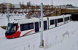 Train exiting the St-Laurent station tunnel | ||||||||||||||||||||||||||||||||||||||||||||||||||||||||||||||||||||||||||||||||||||||||||||||||||||||||||||||||||||||||||||||||||||||||||||||||||||||||||||||||||||||||||||||||||||||||||||||||||||||||||||||||||||||||||||||||||||||||||||||||||||||||||||||||||||||||||||||||||||||||||||||||||||||||||||||||||||||||||||||||||||||||||||||||||||||||||||||||||||||||||||||||||||||||||||||||||||||||||||||||||||||||||||||||||||||||||||||||||||
| Overview | ||||||||||||||||||||||||||||||||||||||||||||||||||||||||||||||||||||||||||||||||||||||||||||||||||||||||||||||||||||||||||||||||||||||||||||||||||||||||||||||||||||||||||||||||||||||||||||||||||||||||||||||||||||||||||||||||||||||||||||||||||||||||||||||||||||||||||||||||||||||||||||||||||||||||||||||||||||||||||||||||||||||||||||||||||||||||||||||||||||||||||||||||||||||||||||||||||||||||||||||||||||||||||||||||||||||||||||||||||||
| Type | Light metro | |||||||||||||||||||||||||||||||||||||||||||||||||||||||||||||||||||||||||||||||||||||||||||||||||||||||||||||||||||||||||||||||||||||||||||||||||||||||||||||||||||||||||||||||||||||||||||||||||||||||||||||||||||||||||||||||||||||||||||||||||||||||||||||||||||||||||||||||||||||||||||||||||||||||||||||||||||||||||||||||||||||||||||||||||||||||||||||||||||||||||||||||||||||||||||||||||||||||||||||||||||||||||||||||||||||||||||||||||||
| System | O-Train | |||||||||||||||||||||||||||||||||||||||||||||||||||||||||||||||||||||||||||||||||||||||||||||||||||||||||||||||||||||||||||||||||||||||||||||||||||||||||||||||||||||||||||||||||||||||||||||||||||||||||||||||||||||||||||||||||||||||||||||||||||||||||||||||||||||||||||||||||||||||||||||||||||||||||||||||||||||||||||||||||||||||||||||||||||||||||||||||||||||||||||||||||||||||||||||||||||||||||||||||||||||||||||||||||||||||||||||||||||
| Status | Under construction | |||||||||||||||||||||||||||||||||||||||||||||||||||||||||||||||||||||||||||||||||||||||||||||||||||||||||||||||||||||||||||||||||||||||||||||||||||||||||||||||||||||||||||||||||||||||||||||||||||||||||||||||||||||||||||||||||||||||||||||||||||||||||||||||||||||||||||||||||||||||||||||||||||||||||||||||||||||||||||||||||||||||||||||||||||||||||||||||||||||||||||||||||||||||||||||||||||||||||||||||||||||||||||||||||||||||||||||||||||
| Locale | Ottawa, Ontario | |||||||||||||||||||||||||||||||||||||||||||||||||||||||||||||||||||||||||||||||||||||||||||||||||||||||||||||||||||||||||||||||||||||||||||||||||||||||||||||||||||||||||||||||||||||||||||||||||||||||||||||||||||||||||||||||||||||||||||||||||||||||||||||||||||||||||||||||||||||||||||||||||||||||||||||||||||||||||||||||||||||||||||||||||||||||||||||||||||||||||||||||||||||||||||||||||||||||||||||||||||||||||||||||||||||||||||||||||||
| Termini |
Tunney's Pasture Blair | |||||||||||||||||||||||||||||||||||||||||||||||||||||||||||||||||||||||||||||||||||||||||||||||||||||||||||||||||||||||||||||||||||||||||||||||||||||||||||||||||||||||||||||||||||||||||||||||||||||||||||||||||||||||||||||||||||||||||||||||||||||||||||||||||||||||||||||||||||||||||||||||||||||||||||||||||||||||||||||||||||||||||||||||||||||||||||||||||||||||||||||||||||||||||||||||||||||||||||||||||||||||||||||||||||||||||||||||||||
| Stations | 13 (+16 approved in stage 2) | |||||||||||||||||||||||||||||||||||||||||||||||||||||||||||||||||||||||||||||||||||||||||||||||||||||||||||||||||||||||||||||||||||||||||||||||||||||||||||||||||||||||||||||||||||||||||||||||||||||||||||||||||||||||||||||||||||||||||||||||||||||||||||||||||||||||||||||||||||||||||||||||||||||||||||||||||||||||||||||||||||||||||||||||||||||||||||||||||||||||||||||||||||||||||||||||||||||||||||||||||||||||||||||||||||||||||||||||||||
| Line number | 1 | |||||||||||||||||||||||||||||||||||||||||||||||||||||||||||||||||||||||||||||||||||||||||||||||||||||||||||||||||||||||||||||||||||||||||||||||||||||||||||||||||||||||||||||||||||||||||||||||||||||||||||||||||||||||||||||||||||||||||||||||||||||||||||||||||||||||||||||||||||||||||||||||||||||||||||||||||||||||||||||||||||||||||||||||||||||||||||||||||||||||||||||||||||||||||||||||||||||||||||||||||||||||||||||||||||||||||||||||||||
| Website | Confederation Line | |||||||||||||||||||||||||||||||||||||||||||||||||||||||||||||||||||||||||||||||||||||||||||||||||||||||||||||||||||||||||||||||||||||||||||||||||||||||||||||||||||||||||||||||||||||||||||||||||||||||||||||||||||||||||||||||||||||||||||||||||||||||||||||||||||||||||||||||||||||||||||||||||||||||||||||||||||||||||||||||||||||||||||||||||||||||||||||||||||||||||||||||||||||||||||||||||||||||||||||||||||||||||||||||||||||||||||||||||||
| Operation | ||||||||||||||||||||||||||||||||||||||||||||||||||||||||||||||||||||||||||||||||||||||||||||||||||||||||||||||||||||||||||||||||||||||||||||||||||||||||||||||||||||||||||||||||||||||||||||||||||||||||||||||||||||||||||||||||||||||||||||||||||||||||||||||||||||||||||||||||||||||||||||||||||||||||||||||||||||||||||||||||||||||||||||||||||||||||||||||||||||||||||||||||||||||||||||||||||||||||||||||||||||||||||||||||||||||||||||||||||||
| Planned opening | Early 2019[1] | |||||||||||||||||||||||||||||||||||||||||||||||||||||||||||||||||||||||||||||||||||||||||||||||||||||||||||||||||||||||||||||||||||||||||||||||||||||||||||||||||||||||||||||||||||||||||||||||||||||||||||||||||||||||||||||||||||||||||||||||||||||||||||||||||||||||||||||||||||||||||||||||||||||||||||||||||||||||||||||||||||||||||||||||||||||||||||||||||||||||||||||||||||||||||||||||||||||||||||||||||||||||||||||||||||||||||||||||||||
| Owner | City of Ottawa | |||||||||||||||||||||||||||||||||||||||||||||||||||||||||||||||||||||||||||||||||||||||||||||||||||||||||||||||||||||||||||||||||||||||||||||||||||||||||||||||||||||||||||||||||||||||||||||||||||||||||||||||||||||||||||||||||||||||||||||||||||||||||||||||||||||||||||||||||||||||||||||||||||||||||||||||||||||||||||||||||||||||||||||||||||||||||||||||||||||||||||||||||||||||||||||||||||||||||||||||||||||||||||||||||||||||||||||||||||
| Operator(s) | OC Transpo | |||||||||||||||||||||||||||||||||||||||||||||||||||||||||||||||||||||||||||||||||||||||||||||||||||||||||||||||||||||||||||||||||||||||||||||||||||||||||||||||||||||||||||||||||||||||||||||||||||||||||||||||||||||||||||||||||||||||||||||||||||||||||||||||||||||||||||||||||||||||||||||||||||||||||||||||||||||||||||||||||||||||||||||||||||||||||||||||||||||||||||||||||||||||||||||||||||||||||||||||||||||||||||||||||||||||||||||||||||
| Depot(s) | Belfast Yards | |||||||||||||||||||||||||||||||||||||||||||||||||||||||||||||||||||||||||||||||||||||||||||||||||||||||||||||||||||||||||||||||||||||||||||||||||||||||||||||||||||||||||||||||||||||||||||||||||||||||||||||||||||||||||||||||||||||||||||||||||||||||||||||||||||||||||||||||||||||||||||||||||||||||||||||||||||||||||||||||||||||||||||||||||||||||||||||||||||||||||||||||||||||||||||||||||||||||||||||||||||||||||||||||||||||||||||||||||||
| Rolling stock | Alstom Citadis Spirit | |||||||||||||||||||||||||||||||||||||||||||||||||||||||||||||||||||||||||||||||||||||||||||||||||||||||||||||||||||||||||||||||||||||||||||||||||||||||||||||||||||||||||||||||||||||||||||||||||||||||||||||||||||||||||||||||||||||||||||||||||||||||||||||||||||||||||||||||||||||||||||||||||||||||||||||||||||||||||||||||||||||||||||||||||||||||||||||||||||||||||||||||||||||||||||||||||||||||||||||||||||||||||||||||||||||||||||||||||||
| Technical | ||||||||||||||||||||||||||||||||||||||||||||||||||||||||||||||||||||||||||||||||||||||||||||||||||||||||||||||||||||||||||||||||||||||||||||||||||||||||||||||||||||||||||||||||||||||||||||||||||||||||||||||||||||||||||||||||||||||||||||||||||||||||||||||||||||||||||||||||||||||||||||||||||||||||||||||||||||||||||||||||||||||||||||||||||||||||||||||||||||||||||||||||||||||||||||||||||||||||||||||||||||||||||||||||||||||||||||||||||||
| Line length | 12.5 km (7.8 mi) | |||||||||||||||||||||||||||||||||||||||||||||||||||||||||||||||||||||||||||||||||||||||||||||||||||||||||||||||||||||||||||||||||||||||||||||||||||||||||||||||||||||||||||||||||||||||||||||||||||||||||||||||||||||||||||||||||||||||||||||||||||||||||||||||||||||||||||||||||||||||||||||||||||||||||||||||||||||||||||||||||||||||||||||||||||||||||||||||||||||||||||||||||||||||||||||||||||||||||||||||||||||||||||||||||||||||||||||||||||
| Track gauge | 1,435 mm (4 ft 8 1⁄2 in) standard gauge | |||||||||||||||||||||||||||||||||||||||||||||||||||||||||||||||||||||||||||||||||||||||||||||||||||||||||||||||||||||||||||||||||||||||||||||||||||||||||||||||||||||||||||||||||||||||||||||||||||||||||||||||||||||||||||||||||||||||||||||||||||||||||||||||||||||||||||||||||||||||||||||||||||||||||||||||||||||||||||||||||||||||||||||||||||||||||||||||||||||||||||||||||||||||||||||||||||||||||||||||||||||||||||||||||||||||||||||||||||
| Electrification | 1500 V DC, Overhead Catenary | |||||||||||||||||||||||||||||||||||||||||||||||||||||||||||||||||||||||||||||||||||||||||||||||||||||||||||||||||||||||||||||||||||||||||||||||||||||||||||||||||||||||||||||||||||||||||||||||||||||||||||||||||||||||||||||||||||||||||||||||||||||||||||||||||||||||||||||||||||||||||||||||||||||||||||||||||||||||||||||||||||||||||||||||||||||||||||||||||||||||||||||||||||||||||||||||||||||||||||||||||||||||||||||||||||||||||||||||||||
| Operating speed | 35[2] km/h (22 mph) | |||||||||||||||||||||||||||||||||||||||||||||||||||||||||||||||||||||||||||||||||||||||||||||||||||||||||||||||||||||||||||||||||||||||||||||||||||||||||||||||||||||||||||||||||||||||||||||||||||||||||||||||||||||||||||||||||||||||||||||||||||||||||||||||||||||||||||||||||||||||||||||||||||||||||||||||||||||||||||||||||||||||||||||||||||||||||||||||||||||||||||||||||||||||||||||||||||||||||||||||||||||||||||||||||||||||||||||||||||
| Signalling | SelTrac (CBTC) | |||||||||||||||||||||||||||||||||||||||||||||||||||||||||||||||||||||||||||||||||||||||||||||||||||||||||||||||||||||||||||||||||||||||||||||||||||||||||||||||||||||||||||||||||||||||||||||||||||||||||||||||||||||||||||||||||||||||||||||||||||||||||||||||||||||||||||||||||||||||||||||||||||||||||||||||||||||||||||||||||||||||||||||||||||||||||||||||||||||||||||||||||||||||||||||||||||||||||||||||||||||||||||||||||||||||||||||||||||
| ||||||||||||||||||||||||||||||||||||||||||||||||||||||||||||||||||||||||||||||||||||||||||||||||||||||||||||||||||||||||||||||||||||||||||||||||||||||||||||||||||||||||||||||||||||||||||||||||||||||||||||||||||||||||||||||||||||||||||||||||||||||||||||||||||||||||||||||||||||||||||||||||||||||||||||||||||||||||||||||||||||||||||||||||||||||||||||||||||||||||||||||||||||||||||||||||||||||||||||||||||||||||||||||||||||||||||||||||||||
The Confederation Line (French: Ligne de la Confédération) is a light metro line under construction in Ottawa, Ontario, Canada. The Confederation Line will be part of the O-Train network operated by OC Transpo along with the existing diesel-powered Trillium Line.[3] While using light rail rolling stock and technology, the Confederation Line is completely grade separated.
The project was approved by Ottawa City Council[4] and the contract was awarded in December 2012. Construction began in 2013[5] and the line is expected to open in early 2019.[1] At a cost of just over $2.1 billion, it is the largest infrastructure project awarded in the history of the city.[6]
History
The line was approved unanimously by the City Council on December 19, 2012 after many years of debate on a rapid transit network for the city. It represents the initial phase of the network and will be implemented through a 30-year Design-Build-Finance-Maintenance agreement with the Rideau Transit Group.[7] The Citadis Spirit light train will be used to provide passenger service.
On June 8, 2016, a sinkhole opened in the middle of Rideau Street near its intersection with Sussex Drive, 25 metres above the LRT tunnel construction, swallowing three lanes of the street and a parked van. The collapse forced evacuation of the Rideau Centre and the closing of a number of local streets and businesses; no one was injured or killed, but the nearly- completed tunnel was flooded, submerging a roadheader. Repairs were completed,[8] and the city was cleared of any wrong-doing.[9]
Testing of the line’s rolling stock began in late 2016, and was planned to continue through most of the following year before the line was expected to open to the public in November 2018.[10][11] In September 2018, it was announced that the line would not open on schedule and would instead open in early 2019.[1]
Route and stations
Route
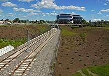
The Confederation Line reaches from Tunney's Pasture station in the west to Blair station in the east, a distance of 12.5 km (7.8 mi)[6] including a 2.5 km (1.6 mi) tunnel running under Queen Street in the central business district. The line connects to the existing Bus Rapid Transitway at both ends, and to the O-Train Trillium Line at Bayview station.[12] With the grade seperation, it is expected that travel time, from one end to another, will be less than 25 minutes.[13]
Stations
There are 13 stations in Stage 1 of the project. The three downtown subway stations have 120 metre platforms; the remainder are 90 metres with provision for future expansion.
- Blair station, connecting with the East Transitway to Orleans.
- Cyrville station
- St. Laurent station, integrated with the St. Laurent Shopping Centre and connecting with east end bus routes.
- Tremblay station, connecting with Via Rail inter-regional services at Ottawa Train Station. A pedestrian bridge has been built to serve Raymond Chabot Grant Thornton Park north of the Queensway.
- Hurdman station, connecting to the Southeast Transitway to south Ottawa.
- Lees station, serving existing high-density residential buildings.
- uOttawa station, serving the University of Ottawa. Replaces the previous Campus station.
- Rideau station, located under Rideau Street, integrated with the Rideau Centre complex. Replaces the existing Mackenzie King station and will be a major transfer station, providing transfers between the Confederation Line and the city's urban bus routes to the east (Montreal Road) and south (Bank Street).
- Parliament/Parlement station, located under Queen Street, replacing the Bank and Metcalfe stations. Direct connection to the Sun Life Centre and Heritage Place.
- Lyon station, located under Queen Street, replacing the Bay and Kent stations. To be integrated with Place de Ville's underground concourse and a future Claridge residential development.
- Pimisi station at LeBreton Flats, connecting with Gatineau busses.
- Bayview station, connecting with the north-south Trillium Line to south Ottawa.
- Tunney's Pasture station, a major federal government employment area, connecting with the Southwest Transitway to Barrhaven and West Transitway to Kanata.
Rolling stock
As part of the winning consortium for the project, Alstom will provide thirty-four[12] Citadis Spirit LRVs. It is the company's first order for modern light rail vehicles in North America, competing directly with similar models such as the Siemens S70 (which was originally ordered for the original extension plan for the Trillium Line but was later cancelled). Derived from the earlier Citadis X-04 series used in Europe, they will be assembled in Alstom's plant in Hornell, New York with final assembly in Ottawa at a new depot and rail yard at Belfast Road and St-Laurent Boulevard, directly behind OC Transpo's headquarters and main bus depot (down the track from Tremblay station).[14][15]
Signalling on the line will be handled by Thales' SelTrac semi-automatic communication-based train control (CBTC) technology.[16] Thales will design, build, maintain the system, and support its installation and commissioning.
As part of a contest organized by OC Transpo, each train set (on both the Confederation Line and the Trilium Line) was named with names that relate to local or Canadian history.[17]
Construction
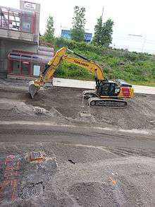
In mid-April 2015, OC Transpo posted a list of bus route changes as a result of the closure of the Transitway between Hurdman station and Blair station.[18] As a result of the closure, many new routes are being created, such as route 91, and existing routes modified, most notably routes 61, 62, 94 and 95. Many routes will use new bus-only lanes on Highway 417, and several others will be altered or shortened to avoid serving the construction area. The changes are meant to provide extra service to those in areas affected by the Transitway closure, and to avoid as many delays as possible while construction on the Confederation Line progresses. A side project on the 417 highway was completed in 2016.
Stage 2 extension
In November 2013, the City of Ottawa released its new transportation master plan,[19] which included plans to build 35 kilometers of new rapid transit and 19 new stations. This also included plans to extend the Confederation Line westward to Moodie station and to Baseline station, and eastward to Place d'Orleans station. In July 2015, the city released a functional report[20] on the Stage 2 system expansion, which added plans to extend the Confederation Line eastward from Place d'Orleans station to Trim station. An extension westward to Moodie Drive from Bayshore station was announced in February 2017.[21] This totals an extension of 11 stations westward and 5 stations eastward.[22]
The city plans to start construction as soon as the first phase is complete in 2019. The full system would be operational by 2023, with the extension to Trim station operational by 2022.[19] The city is currently working on finalizing plans[23] for the current gap in service between Dominion station and Lincoln Fields station where buses travel on the Sir John A. Macdonald Parkway a little over 4 kilometres without stopping. The plan calls for burying trains for most of the route, creating a shorter, straighter alignment. The new route will also include two new LRT stations in an urban area with plenty of densification opportunities.
See also
References
Inline citations
- 1 2 3 Chianello, Joanne. "LRT won't be ready to roll until 2019". CBC.ca. Retrieved September 11, 2018.
- ↑ "Confederation Line - Overview". City of Ottawa.
- ↑ "Transit commission on board with new O-Train name". Metro News. September 17, 2014. Retrieved June 20, 2017.
O-Train passengers could be boarding the expanded and newly named Trillium Line by mid-November
- ↑ "DESIGN, BUILD, FINANCE AND MAINTENANCE OF OTTAWA'S LIGHT RAIL TRANSIT (OLRT) PROJECT" (PDF). DISPOSITION 47. Ottawa City Council. 19 December 2012.
- ↑ "2015 Look Ahead" (PDF). Confederation Line. 2015. Archived from the original on 2015-09-25. Retrieved 2015-06-11.
- 1 2 Schepers (December 4, 2012), p.6
- ↑ Schepers (December 4, 2012), p.1
- ↑ Pearson, Matthew (July 29, 2016). "LRT tunnel work under Rideau to resume next week". Ottawa Sun. Retrieved 2017-03-15.
- ↑ Pritchard, Trevor (December 22, 2016). "Rideau Street sinkhole collapse not city's fault, says chief solicitor". Canadian Broadcasting Corporation. Retrieved 2017-03-15.
- ↑ Willing, Jon (February 6, 2018). "City to open LRT by the end of November". Ottawa Citizen. Retrieved February 10, 2018.
- ↑ "Ottawa, Alstom begin light rail testing on O-Train line". Trains Magazine. December 7, 2016. Retrieved December 7, 2016.
- 1 2 "Confederation Line". City of Ottawa. 2015. Archived from the original on 2015-06-13. Retrieved 2015-06-11.
- ↑ "Ready for Rail: How Often Will It Come? | Ottawa Confederation Line". www.ligneconfederationline.ca. Retrieved 2018-10-11.
- ↑
"Alstom launches North American light rail vehicle with Ottawa contract". Railway Gazette. 2013-02-14. Archived from the original on 2014-09-06.
With a similar configuration to Citadis Dualis tram-trains used in the French cities of Nantes and Lyon, the version of the Citadis Spirit for Ottawa will be a 100% low-floor LRV with a top speed of 100 km/h and space for bicycles. It will be equipped to operate in 'extreme' winter conditions.
- ↑ Vantuono, William (February 14, 2013). "Alstom finalizes Ottawa LRT contract". Railway Age. Retrieved June 20, 2017.
- ↑ "Ottawa LRT signalling award for Thales". Global Rail News. March 5, 2013. Archived from the original on April 10, 2013.
- ↑ "Take the 'Eh-Train': Ottawa reveals names of 40 LRT cars | CBC News". CBC. Retrieved 2018-10-11.
- ↑ "OC Transpo - On Track 2018". April 2015. Retrieved 19 April 2015.
- 1 2 "Transportation Master Plan". City of Ottawa. Retrieved 2 March 2015.
- ↑ City of Ottawa (2015-06-29). "Stage 2 LRT". Stage 2 LRT Resources. City of Ottawa. Retrieved 2015-07-06.
- ↑ "'The west is finally in': $3.6B rail package includes LRT to Moodie Drive". Ottawa Citizen. 2017-02-17. Retrieved 2017-08-19.
- ↑ "Stage 2 - East, West and South". City of Ottawa. 2015. Retrieved 2015-08-01.
- ↑ "Unsatisfied with City proposal partially bury western extension". Ottawa Citizen. Archived from the original on June 19, 2013. Retrieved June 12, 2013.
Bibliography
- Schepers, Nancy (December 4, 2012). "DESIGN, BUILD, FINANCE AND MAINTENANCE OF OTTAWA'S LIGHT RAIL TRANSIT (OLRT) PROJECT" (PDF). Report to Council. City of Ottawa. Retrieved June 20, 2017.
- Schepers, Nancy (June 22, 2015). Report to Finance and Economic Development Committee 29 June 2015 and Council 8 July 2015. Submitted on June 22, 2015 by Nancy Schepers, Executive Advisor, Light Rail Planning and Implementation. File Number: ACS2015-CMR-OCM-0017. SUBJECT: STAGE 2 LIGHT RAIL TRANSIT (LRT) ENVIRONMENTAL ASSESSMENT AND FUNCTIONAL DESIGN REPORT. Retrieved July 6, 2015.
- OC Transpo's Announcement video of their chosen Light Rail Vehicle
External links
OC Transpo services in Ottawa | |||||||||||||||||||||||||
|---|---|---|---|---|---|---|---|---|---|---|---|---|---|---|---|---|---|---|---|---|---|---|---|---|---|
| |||||||||||||||||||||||||
| |||||||||||||||||||||||||
| |||||||||||||||||||||||||
| |||||||||||||||||||||||||
Coordinates: 45°25′09″N 75°40′45″W / 45.41905°N 75.67906°W