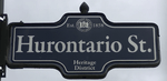
Hurontario Street
Main Street Centre Road | |||||||
|---|---|---|---|---|---|---|---|
|
Highway 10 Simcoe County Road 124 | |||||||
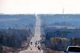
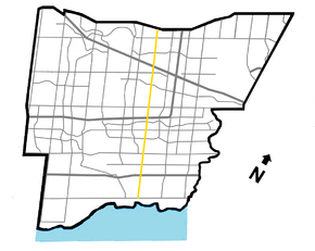 Hurontario St. within Mississauga | |||||||
| Route information | |||||||
|
Maintained by City of Mississauga City of Brampton Ontario Ministry of Transportation Town of Orangeville Town of Mono Township of Mulmur Simcoe County Town of Collingwood | |||||||
| Existed | 1818[1] – present | ||||||
| Major junctions | |||||||
| South end | Lakeshore Road in Mississauga | ||||||
|
Dundas Street Burnhamthorpe Road Eglinton Avenue Queen Street Beuna Vista Drive ------ Name/Course break ------ Resumes at/as | |||||||
| North end | Side Launch Way in Collingwood | ||||||
| Location | |||||||
| Divisions |
Peel Dufferin Simcoe | ||||||
| Major cities |
Mississauga Brampton | ||||||
| Towns |
Caledon Orangeville Mono Collingwood | ||||||
| Highway system | |||||||
| |||||||


Hurontario Street is a roadway running in Ontario, Canada between Lake Ontario at Mississauga and Lake Huron's Georgian Bay at Collingwood. Within Peel Region, it is a major urban thoroughfare within the cities of Mississauga and Brampton, which serves as the divide from which cross-streets are split into East and West, except at its foot in the historic Mississauga neighbourhood of Port Credit. Farther north, with the exception of the section through Simcoe County, where it forms the 8th Concession, it is the meridian for the rural municipalities it passes through. In Dufferin County, for instance, parallel roads are labelled as EHS or WHS for East (or West) of Hurontario Street. Due to its role as a divider for much of its length, most it was named Centre Road historically,[1] and still is today in parts. The name "Hurontario" is a portmanteau of the street's two terminating lakes; Huron and Ontario.
Within much of Brampton, the road is named Main Street.
Provincial Highway 10 follows the road through Caledon as far north as Orangeville. The highway designation formerly continued south through Brampton and Mississauga, but the highway was downloaded through both cities in 1997 due to its increasingly urbanized nature and the presence of the 400-series Highways 410 and 403. Highway 24 followed much of the street's northern section (as well as the central section where it ran concurrently with Highway 10) from near Glen Huron to Collingwood, but was also downloaded (to Simcoe County), as it was deemed by the province to be of insufficient importance to be retained in the highway system, and is now known as Simcoe County Road 124 through that stretch.
In addition to these two highways that followed most of its course, Highways 7 and 26 jogged along it for short distances through Brampton and Collingwood, respectively, before being rerouted.
History
Hurontario Street was created in 1818 by redesignating the combination of the 8th Concession leading south from the harbour on Georgian Bay that later became the site of Collingwood, and the southern part of the Toronto-Sydenham Road, which ran between Sydenham and Toronto Township (present and former Highway 10 between Owen Sound and Mississauga), effectively creating a branched interlake route. As previously mentioned, parts were also called Centre Road due to it being the meridian for the townships it traversed. The Centre Road name continued to be used interchangeably at least until the 1950s,[2] and a section bypassed by former Highway 24 is still officially named Centre Road today.
Route description
Mississauga and Brampton
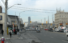
The street begins in Mississauga at Lakeshore Road in Port Credit. North of the Canadian National rail underpass, it enters the low-density residential district of Mineola, which extends north to the Queen Elizabeth Way. Then it enters the Cooksville neighbourhood, a higher-density area of highrises and commercial development. At Burnhamthorpe Road, Hurontario passes through Mississauga's City Centre, with the spectacular Absolute World condominium towers rising at the northeast corner. After crossing Highway 403, it passes through more suburban mid-density residential development until it approaches Matheson Boulevard, where a preserved historic farmstead, the Britannia Farm, operated by the Peel District School Board, is located. The road then enters an industrial and commercial area, still under development, which extends beyond Highway 401 all the way to the city limits near Highway 407.
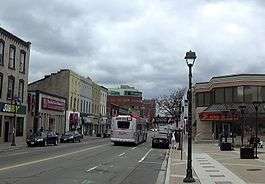
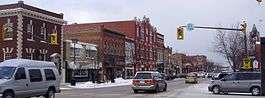
Hurontario then enters Brampton, where it changes name to Main Street after crossing Steeles Avenue. Main St. runs alongside the Etobicoke Creek valley until reaching Brampton's downtown, where it passes landmarks such as Gage Park, Brampton City Hall, and the Rose Theatre Brampton. At Bovaird Drive (formerly Highway 7), the name Hurontario resumes, and the street passes through a lengthy mixed residential/industrial rural-urban fringe zone until it reaches Highway 410 at Brampton's northern city limits.
Caledon to Collingwood
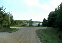
At Highway 410, the Highway 10 designation begins as the street enters rural Caledon, and it has a discontinuity through the interchange as it defaults onto Valleywood Boulevard northbound and the 410 southbound, with ramps connecting the two sections. The road continues northward as the undivided four-lane Highway 10 until reaching Orangeville, where the highway leaves the Hurontario Street alignment to head for the City of Owen Sound, although it parallels it very closely for about 21 km. (13 mi.) as it follows First Line WHS. The reason for the highway's chosen alignment was due to old Orangeville's location farther to the west and (in the case of the former Highway 24 segment to the north), difficult terrain. In Orangeville, it runs as a residential side street and breaks at the Orangeville Reservoir. In Mono, it resumes as a minor sideroad to Highway 89, where it breaks again. It resumes once more in Mulmur Township as a series of broken minor roads with several names (including the aforementioned Centre Rd.) north of Boyne Valley Provincial Park, passing through the hamlets of Dunedin and Glen Huron. North of Glen Huron, it becomes a major road again as it joins Simcoe County Road 124 (which, along with Highway 10, carries the Orangeville-Collingwood through traffic south of this point), until its terminus in Collingwood at Side Launch Way, one block north of First and Huron Streets (Highway 26). The final block is a short one-way northbound extension built in 2009[3] to serve a residential redevelopment project on the site once occupied by the now-closed Collingwood Shipyards.
Vernacular
In the cities of Mississauga and Brampton (with the exception of the latter's downtown area), the street is still colloquially referred to by traffic reporters, and even by residents, as "Highway 10" rather than by its street names, despite the high degree of urbanization and the fact that the provincial highway designation is defunct in these cities. A prime example of this is the common reference to the street's intersection with Dundas Street as "5 and 10". The most likely reason for this is the combination of the street being mostly suburban, and the fact that Mississauga is not a traditional prewar city, but was established much later as a reincorporation of the rural Toronto Township,[4] thus the road never had a history of being a city street prior to receiving its highway designation. Even the Ministry of Transportation's traffic camera continues to identify the street as "Hwy 10",[5] as does some signage at the Hurontario & 407 Park and Ride lot and transit terminal. However, the street name predominates in Collingwood.
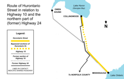
One result of the use of the terminology is the frequent conflation of Hurontario St. as corresponding to the entire length of Highway 10 to Owen Sound, due to the highway's northern terminus being in that city, which is coincidentally also situated on Lake Huron's Georgian Bay (See diagram on right for route comparison).
Public transit
Hurontario St. is one of the busiest transit corridors in the 905 Region of the Greater Toronto Area. Mississauga and Brampton each run separate systems, but routes cross city boundaries. In addition to local routes operated by both cities, Brampton Transit operates a rudimentary bus rapid transit line along it, branded as Züm, and Mississauga's MiWay runs a limited-stop express bus route. The MiWay express bus and the southern portion of Zűm are slated to be replaced by a proposed light rail transit line that is to be constructed along the street in Mississauga and a short distance in Brampton (see Hurontario LRT). The project has received funding approval by the Government of Ontario.[6] It is currently in the design phase and construction is projected to begin by late 2018.[7]
In Caledon, GO Transit runs a commuter bus route along the road to Orangeville from Brampton's downtown bus terminal. There is also partial service along the street in Collingwood, provided by Colltrans.
The base trunk routes serving the street are:
Mississauga (MiWay):
| Route | Direction and Termini | ||||
|---|---|---|---|---|---|
19 |
Hurontario[8] | NB | To Hurontario & 407 Park and Ride | SB | To Port Credit GO station via Mississauga City Centre Transit Terminal |
103 |
Hurontario Express[9] | NB | To Brampton Gateway Terminal (Steeles Avenue) |
SB | To Port Credit GO station Bypasses City Centre Transit Terminal |
Brampton (Brampton Transit):
| Route | Direction and Termini | ||||
|---|---|---|---|---|---|
2 |
Main[10] | NB | To Heart Lake Town Centre via Sandalwood Parkway |
SB | To Maritz Drive (Derry Road) via Highway 407 Park and Ride |
502 |
Züm Main | NB | To Sandalwood Parkway | SB | To Mississauga City Centre Transit Terminal Bypasses Highway 407 Park and Ride and Downtown Brampton Terminal |
Caledon (GO Transit)
| Route | Direction and Termini | ||||
|---|---|---|---|---|---|
37 |
Orangeville/Brampton[11] | NB | To Orangeville GO Park and Ride | SB | To Brampton Downtown Terminal |
Collingwood (Colltrans)
The East Route[12] operates along Hurontario for part of its run.
Attractions and institutions along Hurontario Street
Attractions and institutions along Hurontario Street in urban Peel Region include (south to north):
- Historic Port Credit
- Absolute World condominium towers
- Square One Shopping Centre
- Britannia Farm
- Peel District School Board Headquarters, Mississauga.
- Dufferin-Peel Catholic District School Board Headquarters, Mississauga.
- A. Grenville and William Davis Courthouse, Brampton.
- Shoppers World Brampton
- Gage Park
- Peel Art Gallery, Museum and Archives
- Rose Theatre
Caledon to Collingwood:
- Caledon Fairgrounds
- Orangeville Reservoir
- Devil's Glen Provincial Park
- Batteaux Creek Golf and Country Club, Nottawa
References
- 1 2 "History Bytes". Heritage Mississauga. Mississauga Heritage Foundation. Retrieved March 31, 2017.
- ↑ "A Brief History of Public Transit in Mississauga Mississauga Transit/Miway Image Archive—Arrow Bus Lines schedule". Transit Toronto. Retrieved November 23, 2017.
- ↑ "Google Maps view of construction of street extension in Collingwood in 2009".
- ↑ "1968 – Amalgamation to form the Town of Mississauga". mississauga.ca. Retrieved September 18, 2017.
- ↑ "COMPASS Traffic Cameras - QEW - Halton, Peel Regions". Ministry of Transportation of Ontario. April 2008. Retrieved 2008-04-26.
- ↑ "Newsroom: Ontario Moving Forward with Hurontario-Main Light Rail Transit Project".
- ↑ "Hurontario Light Rail Transit (LRT)". Metrolinx. Retrieved March 31, 2017.
- ↑ "19 Hurontario" (PDF). MiWay Route Maps. City of Mississauga. 28 January 2013. Retrieved March 31, 2017.
- ↑ "103 Hurontario Express" (PDF). MiWay Route Maps. City of Mississauga. 2 September 2013. Retrieved November 23, 2015.
- ↑ "2 Main" (PDF). Brampton Transit Route Maps. City of Brampton. 2 November 2015. Retrieved March 31, 2017.
- ↑ "37 Orangeville-Brampton" (PDF). Maps. GO Transit. Retrieved March 31, 2017.
- ↑ "Colltrans Route Map and Schedule" (PDF). Colltrans. Retrieved March 31, 2017.