Metro Line
| Metro Line | |||
|---|---|---|---|
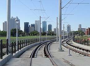 Metro Line approaching Downtown Edmonton | |||
| Overview | |||
| Type | Light rail | ||
| Locale | Edmonton | ||
| Termini |
NAIT Health Sciences/Jubilee | ||
| Stations | 14 | ||
| Operation | |||
| Opened | September 6, 2015[1] | ||
| Operator(s) | Edmonton Transit System | ||
| Character | Mostly at-grade with underground sections in downtown.[2] | ||
| Depot(s) |
D.L. MacDonald Yard Northwest LRT Yard (proposed)[3] | ||
| Technical | |||
| Number of tracks | 2 | ||
| Track gauge | 1,435 mm (4 ft 8 1⁄2 in) | ||
| Operating speed | 80 kilometres per hour (50 mph) maximum[4] | ||
| |||

The Metro Line is a light rail transit line on the Edmonton LRT system. The line operates from northwest Edmonton to southwest Edmonton, and was scheduled to have begun operation by spring 2014 but instead opened on September 6, 2015, at a reduced speed and frequency.[5] The line uses 3.3 kilometres (2.1 mi) of new track,[6] three new stations, and eleven stations on the existing Capital Line. The cost of the project was $665 million, jointly funded by the City of Edmonton, Province of Alberta, and the Government of Canada.[6][7] It is the first new line that is not an extension of the existing line. The line was expected to add 13,200 riders per weekday.[8] A trip from NAIT station to Churchill is expected to take nine minutes.[9] A number of roadworks are under construction or completed to revitalize the surrounding community. An extension to the northwest city limits has completed conceptual design,[10] and a further extension is proposed through the city of St. Albert on Highway 2/St. Albert Trail.[11]
History
In spring 2007, the funding for a concept plan and preliminary engineering was commissioned, and the City approved the plan the next year.[12] In 2008, during construction of the Epcor Tower, the City ordered that the tunnel section below the tower be dug before the tower was completed, this saved $140 million from digging after the tower was built.[13][14] The remainder of the tunnel, under Downtown Edmonton, was constructed using the sequential excavation method, and completed in November 2012.[15] In 2009 the City approved the relocation of funds from the Gorman extension to the Metro Line, as the City felt northwest was a higher priority.[16][17] In 2010 the City began preparation work, including utility relocations, building removals, roadwork, Kingsway road reconstruction and track slab construction.[18][12] The permanent closure of 105 Avenue between 102 Street and 105 Street was performed so MacEwan Station could be built. 105 Street was permanently closed to vehicular traffic between 107 Avenue and 108 Avenue to allow the line to continue along the existing road corridor, which alleviated the need to widen the corridor and remove some existing trees. 104 Street was closed between 108 Avenue and Kingsway in a similar fashion.[9] Construction was completed in 2014 in time to accommodate a spring 2014 opening.[19] Bus service began for the first Metro Line facility, the Kingsway/Royal Alex Transit Centre, on June 29, 2014.[20] The public plaza surrounding MacEwan Station, except for the area required to build Rogers Place, opened for use by people other than the construction crew in December 2014.[21]
Testing began in July 2013,[9] and the line began operation in September 2015 with restrictions.[22][5][23][24][25] There have been three delays in beginning operations on the line: one from April to June 2014, one from June to December 2014, and another from December 2014 to February 2015. The delays have been caused by issues with the signalling system built by Thales.[26][27][28] Thales gave control of the system to the City of Edmonton in March 2015, but failed to provide adequate documentation to place the line into service.[23] In February 2017, trains were cleared to travel at 50 km/h.[29]
In September, 2018, the Toronto Star reported that Edmonton had given Thales until April 30, 2017, to bring the system to full functionality.[30] Edmonton had withheld $22 million from Thales, until the system was fully functional. When Thales did not meet this deadline Edmonton gave Thales a "notice of default". On September 13, 2018, Edmonton announced Thales had promised the signalling system would be fully functional by December 2018.[31] Edmonton also announced there was a backup plan, to keep the route functioning, if Thales failed to deliver.
Future
Edmonton extension
An extension from the permanent NAIT station is in the planning phases by the City of Edmonton.[32] The recommendation, released in May 2010,[33] extends the Metro Line through the neighbourhood created by the dismantling of the City Centre (Blatchford Field) Airport, over Yellowhead Trail and the CN Railway yard, along 113A Street and 153 Avenue to the City of St. Albert limits.[6] The extension would have eight stations, including stops in Blatchford (the neighbourhood created by the airport redevelopment), Rosslyn, Griesbach, Castle Downs, The Palisades, and at Campbell Road.[32] As part of this extension, a park and ride is proposed at Campbell Rd and 153 Ave. This type of line is planned to run with less separation from other traffic, mostly with lower track speeds, no higher than general purpose traffic, still with traffic signal priority and dedicated lanes. This extension is 11 km long, and will have 8 new stations and a rebuilt NAIT station slightly to the west of its current location. This section of the line is not planned to use gate arms, bells and flashing lights as has been done with the Metro Line from NAIT to Churchill.[34]
St. Albert extension
The City of St. Albert began studying extending Edmonton's LRT in early 2013, identifying four possible locations for stations.[35]On November 12, 2013, St. Albert council decided to continue studying LRT alignment options, but not to put any money into purchasing land or rail cars.[36] The selected corridor was approved by St. Albert city council on December 2, 2014, which will run on St. Albert Trail and proposed four possible station locations. The line is proposed to be primarily aligned to the east of St. Albert Trail, reducing it to four lanes north of Hebert Road. As well, there are three new bridges proposed along the St. Albert extension to span Anthony Henday Drive, Sir Winston Churchill Avenue, and the Sturgeon River.[37]
Stations
- Notes
- ^1 : The Metro Line does not stop at these stations on weekdays after 10 PM, Saturdays after 7 PM or on Sundays.[38]
Future stations
The City of Edmonton approved the concept plan for a northwest LRT line, and nine stations, May 1, 2013.[39][40][41]
| Station | Area | Location |
|---|---|---|
| Campbell Road | Northwest | 53°36′56″N 113°35′38″W / 53.61556°N 113.59389°W |
| 137 Street | Northwest | 53°36′52″N 113°33′30″W / 53.61444°N 113.55833°W |
| 127 Street | Northwest | 53°37′1″N 113°32′23″W / 53.61694°N 113.53972°W |
| Castle Downs | Northwest | 53°36′52″N 113°31′8″W / 53.61444°N 113.51889°W |
| 145 Avenue | Northwest | 53°36′28″N 113°31′0″W / 53.60778°N 113.51667°W |
| Griesbach | Northwest | 53°36′2″N 113°30′59″W / 53.60056°N 113.51639°W |
| 132 Avenue | Northwest | 53°35′28″N 113°31′0″W / 53.59111°N 113.51667°W |
| Blatchford | Northwest | 53°34′33″N 113°30′37″W / 53.57583°N 113.51028°W |
| NAIT station | Northwest | 53°34′0″N 113°30′33″W / 53.56667°N 113.50917°W |
Proposed stations
The City of St. Albert identified four possible locations for stations in early 2013. In October 2015, the preferred location and alignment of the St. Albert extension was published in the Phase 2 report for the extension. Transit stations are proposed for the Downtown St. Albert, and the North St. Albert stations while park and ride services are only proposed for North St. Albert station.[37]
|
|
References
- ↑ Ramsay, Caley (September 6, 2015). "After lengthy delay, Metro Line LRT opens to riders". Global Edmonton. Retrieved September 6, 2015.
- ↑ "Metro Line (NAIT to North City Limits) - Route Maps". City of Edmonton. Archived from the original on March 26, 2015. Retrieved December 2, 2014.
- ↑ "Northwest LRT - Campbell Station" (PDF). City of Edmonton. Retrieved December 12, 2014.
- ↑ "SD160 Light Rail Vehicle" (PDF). Siemens. Archived from the original (PDF) on 29 September 2012. Retrieved 2 February 2011.
- 1 2 "Metro Line Delay FAQ" (PDF). City of Edmonton. October 8, 2014. Archived from the original (PDF) on October 13, 2014. Retrieved October 8, 2014.
- 1 2 3 Dykstra, Matt (May 9, 2013). "Edmonton city crews promise to finish north extension of LRT line to NAIT by next spring". Edmonton Sun. Retrieved August 26, 2013.
- ↑ Lent, Gordon (April 10, 2014). "NAIT LRT savings to help Valley Line budget, report says". Edmonton Journal. Retrieved April 10, 2014.
- ↑ Callsen, Laurie (October 25, 2012). "Five projects to watch go up in downtown Edmonton". Metro News. Retrieved August 26, 2013.
- 1 2 3 "North LRT to NAIT (Metro Line)". City of Edmonton. Retrieved August 26, 2013.
- ↑ "Metro Line (NAIT to North City Limits)". City of Edmonton. Archived from the original on March 26, 2015. Retrieved December 2, 2014.
- ↑ Dubois, Stephanie (December 2, 2014). "St. Albert council approves alignment for LRT in city". Metro Edmonton. Retrieved December 2, 2014.
- 1 2 "North LRT (Metro Line) Project History". City of Edmonton. Archived from the original on September 4, 2013. Retrieved August 26, 2013.
- ↑ "Work on LRT's third leg to start in June". Edmonton Journal. Canada.com. April 3, 2008. Archived from the original on January 30, 2014. Retrieved August 26, 2013.
- ↑ "LRT line likely to go under Epcor". Edmonton Journal. Canada.com. April 9, 2008. Archived from the original on October 5, 2008. Retrieved August 26, 2013.
- ↑ Callsen, Laurie (November 16, 2012). "New Edmonton LRT tunneling for NAIT line completed". Metro News. Retrieved August 26, 2013.
- ↑ Van Alstine, Brendan (May 25, 2009). "LRT expansion takes people by surprise". Metro News. Retrieved August 26, 2013.
- ↑ Gould, Brian (February 8, 2010). "Council setting the right tone for LRT expansion". Metro News. Retrieved August 26, 2013.
- ↑ Edmonton, City of (2018-08-29). "Metro Line North Project History". www.edmonton.ca. Retrieved 2018-08-29.
- ↑ Edmonton, City of (2018-08-29). "Metro Line North Project History". www.edmonton.ca. Retrieved 2018-08-29.
- ↑ Edmonton, City of (2018-08-29). "Metro Line North Project History". www.edmonton.ca. Retrieved 2018-08-29.
- ↑ "METRO LINE UPDATE" (PDF). City of Edmonton. Archived from the original (PDF) on December 24, 2014. Retrieved December 2014.
Metro Line to open in early 2015
Check date values in:|accessdate=(help) - ↑ Edmonton, City of (2018-08-29). "Metro Line North Project History". www.edmonton.ca. Retrieved 2018-08-29.
- 1 2 Kent, Gordon (August 1, 2015). "City explores 'interim service' for problem-plagued Edmonton Metro LRT line". Edmonton Journal. Retrieved August 3, 2015.
- ↑ "NAIT LRT opening delayed by two months for system testing". CTV News Edmonton. December 4, 2013. Retrieved December 4, 2013.
- ↑ "NAIT LRT extension delayed by two months". CBC News. December 4, 2013. Retrieved December 4, 2013.
- ↑ Tumilty, Ryan (December 4, 2013). "Edmonton's new NAIT LRT line won't open on time". Metro News. Retrieved December 16, 2014.
- ↑ Tumilty, Ryan (March 20, 2014). "Edmonton's NAIT LRT line delayed". Metro News. Retrieved December 16, 2014.
- ↑ Mertz, Emily (October 8, 2014). "Opening of Edmonton's Metro LRT Line delayed for third time". Global News. Retrieved December 16, 2014.
- ↑ http://www.cbc.ca/news/canada/edmonton/metro-lrt-gets-green-light-to-run-full-speed-through-intersections-1.3984614
- ↑
Kevin Maimann (2018-09-18). "Edmonton council reassured Metro Line LRT will keep running if contractor can't deliver". Toronto Star. Edmonton. Retrieved 2018-09-21.
The Metro Line has seen a series of failures over the past four years, working through delays and a slower LRT schedule due to a semifunctional signalling system.
- ↑
Kashmala Fida (2018-09-13). "Rejoice! The Metro Line could be fully functional by December: city". Toronto Star. Edmonton. Retrieved 2018-09-21.
However, the report does note that if the contract fails, the city has developed an alternate signalling system that will replace Thales’s Communication Based Train Control (CBTC) system to make sure that Edmontonians don’t lose any service on the Metro Line.
- 1 2 "Northwest LRT to City Limits". City of Edmonton. Archived from the original on September 3, 2013. Retrieved August 26, 2013.
- ↑ Ho, Clara (May 19, 2010). "City announces planned LRT route to St. Albert". Edmonton Sun. Retrieved August 26, 2013.
- ↑ "Archived copy" (PDF). Archived from the original (PDF) on September 4, 2013. Retrieved September 13, 2013.
- ↑ "St. Albert LRT" (PDF). City of St. Albert. February 23, 2013. Archived from the original (PDF) on May 20, 2013. Retrieved August 26, 2013.
- ↑ Paterson, Victoria (November 13, 2013). "Council rejects delay to LRT study". St. Albert Gazette. Retrieved November 17, 2013.
- 1 2 "St. Albert LRT Planning Study: Phase 2 - Alignment Selection Report" (PDF). AECOM and ISL Engineering and Land Services. October 2015. Retrieved December 28, 2016.
- ↑ https://www.edmonton.ca/ets/metro-line.aspx
- ↑ "Northwest LRT Project History". City of Edmonton. Archived from the original on September 4, 2013. Retrieved September 13, 2013.
- ↑ "Concept Planning Study Northwest LRT" (PDF). City of Edmonton. May 1, 2013. Archived from the original (PDF) on September 4, 2013. Retrieved September 13, 2013.
- ↑ "Northwest LRT Recommended Concept Plan" (PDF). City of Edmonton. April 2013. Archived from the original (PDF) on September 4, 2013. Retrieved September 13, 2013.
External links
- ETS Metro Line web page – The City of Edmonton
- Metro Line (NAIT to North City Limits) Project page - City of Edmonton
- North LRT - Churchill to NAIT on YouTube published by the City of Edmonton. Animated tour of the Metro Line from Churchill Station to NAIT Station.
Edmonton Transit System LRT stations | |||
|---|---|---|---|
| Capital Line | |||
| Metro Line |
| ||
| Valley Line (2020) | |||
Edmonton portal | |||