Weston Road
| |
|---|---|
| York Regional Road 56 | |
 Weston Rd. within Toronto | |
| Route information | |
|
Maintained by City of Toronto Region of York | |
| Major junctions | |
| South end | St. Clair Avenue (Continues as Keele Street) |
|
Black Creek Drive Eglinton Avenue Jane Street Lawrence Avenue Albion Road / Walsh Avenue Sheppard Avenue Finch Avenue Steeles Avenue | |
| North end |
|
| Highway system | |
| Roads in Ontario | |


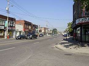
Weston Road is a north-south street in the west end of Toronto and western York Region in Ontario, Canada. The road is named for the former Village of Weston, which was located near Weston Road and Lawrence Avenue West.
Route description
In the south, Weston Road begins at St. Clair Avenue opposite the north end of the southern leg of Keele Street. The southernmost 55 metres of the street north of St. Clair, where the roadway diverted to the west off its straight baseline, was formerly a part of Keele, which officially breaks here and is cut off from its northern section. Weston Road formerly began at the diversion, but this stretch of Keele St. was redesignated as part of Weston Rd. in 2006.[1] Weston Rd. then travels diagonally in a northwesterly direction to Highway 401, passing through Mount Dennis at Eglinton Avenue, and Weston north of Lawrence Avenue. North of the 401, it is a north-south road running parallel to Highway 400, following the former Sixth Line West to Steeles Avenue and into York Region.
Most of Weston Road is a four-lane principal arterial road through residential areas, except for the northern section which is mostly industrial. The speed limit south of Finch Avenue is 50 km/h (30 mph), which increases to 60 km/h (35 mph) between Finch and Steeles.
Additionally, there is an Old Weston Road, part of the original road that continues near and somewhat parallel to Weston in the environs of its southern terminus. It essentially runs as an extension of Davenport Road, running northwards towards Rogers Road, a short distance east of Weston Road. It passes through the neighbourhood of Silverthorne. It starts at Dundas Street and Dupont. It once ran directly north from there to St. Clair, but this road was closed in the 1970s and has since been removed south of Junction Road.
North of the Toronto city limits at Steeles Avenue, Weston Road enters York Region, where it is designated as York Regional Road 56. it passes through the two western municipalities of York Region, Vaughan in the south and King in the north. The speed limit through the urbanized parts of Vaughan is 60 km/h (35 mph), while the limit is 80 km/h (50 mph) in rural Vaughan and King Township. The northern terminus of the road is at Highway 9 in the Holland Marsh.
History
Weston Road was first laid out in the first decade of the 1800s to connect Dundas Street to the village of Weston. This followed the route of what is today "Old Weston Road", then the route of the current Weston Road north to Weston. Between 1810 and 1820, it was extended north to Vaughan Township. In 1841, the route was bought by private interests and it became the "Weston Plank Road", a toll road of planks. The Weston Plank Road extended from Dundas Street north to Musson's Bridge over the Humber, where Albion Road begins. The company built its headquarters at St. Phillip Road and Weston Road. The building exists today at 2371 Weston Road. In 1846, the Weston Plank Road Company built Albion Plank Road from Musson's bridge north-west to Bolton. In the 1850s, the roads were assumed by the township and its municipalities.[2]
Other information
Two bus routes serve Weston Road: 89 Weston (serving the stretch from Albion Road to St. Clair Avenue West, then via Keele Street to Keele station) and 165 Weston Road North (serving from Steeles Avenue West to the stretch from Albion Road, then via Wilson Avenue to Wilson station and York Mills station). Starting Sunday October 7 2018, there will one express bus routes serving Weston Road: 989 Weston Express (serving between Keele station and Steeles Avenue West).
North of Steeles Avenue operates the York Region Transit 165 Weston along Weston Road, running from Pioneer Village station to Major Mackenzie Drive in Vaughan.
The road is mentioned on Toronto native Drake's 2016 album Views, in the song "Weston Road Flows". The road is also mentioned in his 2018 song, "God's Plan".
See also
References
- ↑ "Bylaw 434-2006" (PDF). City of Toronto. Retrieved December 1, 2010.
- ↑ "Appendix A-1: Cultural Landscape and Built Heritage – Existing Conditions: Review" (PDF) (pdf). City of Toronto. Retrieved July 19, 2016.
External links
Major roads, highways and streets in Toronto | |||||||||
|---|---|---|---|---|---|---|---|---|---|
| North–south |
| ||||||||
| East–west |
| ||||||||
| |||||||||
| |||||||||