Pommereuil
| Le Pommereuil | ||
|---|---|---|
| Commune | ||
 | ||
| ||
 Le Pommereuil Location within Hauts-de-France region  Le Pommereuil | ||
| Coordinates: 50°06′46″N 3°35′48″E / 50.1127°N 3.5967°ECoordinates: 50°06′46″N 3°35′48″E / 50.1127°N 3.5967°E | ||
| Country | France | |
| Region | Hauts-de-France | |
| Department | Nord | |
| Arrondissement | Cambrai | |
| Canton | Le Cateau-Cambrésis | |
| Intercommunality | Caudrésis–Catésis | |
| Government | ||
| • Mayor (2008–2014) | Marc Dufrenne | |
| Area1 | 6.45 km2 (2.49 sq mi) | |
| Population (2009)2 | 759 | |
| • Density | 120/km2 (300/sq mi) | |
| Time zone | UTC+1 (CET) | |
| • Summer (DST) | UTC+2 (CEST) | |
| INSEE/Postal code | 59465 /59360 | |
| Elevation | 91–153 m (299–502 ft) | |
|
1 French Land Register data, which excludes lakes, ponds, glaciers > 1 km2 (0.386 sq mi or 247 acres) and river estuaries. 2 Population without double counting: residents of multiple communes (e.g., students and military personnel) only counted once. | ||
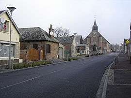
Pommereuil or Le Pommereuil is a commune in the Nord department in northern France.
History
The village and surrounding woods (Bois l'Évêque) were heavily damaged by a tornado on June 24, 1967, a relatively rare occurrence in France.
Heraldry
_Nord-France.svg.png) |
The arms of Le Pommereuil are blazoned : Argent, a cross moline sable. (Challes-les-Eaux, Montalembert, Neuvilly and Le Pommereuil use the same arms.) |
Monuments
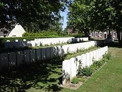
Pommereuil British Cemetery
- The church, Église Saint-Michel, was built during the 17th Century and has a fortified tower.
See also
References
| Wikimedia Commons has media related to Pommereuil. |
This article is issued from
Wikipedia.
The text is licensed under Creative Commons - Attribution - Sharealike.
Additional terms may apply for the media files.