Tschirn
| Tschirn | ||
|---|---|---|
 | ||
| ||
 Tschirn Location of Tschirn within Kronach district 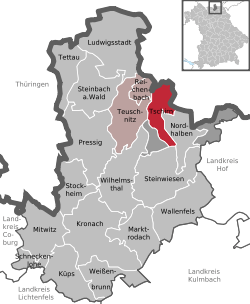 | ||
| Coordinates: 50°23′49″N 11°26′59″E / 50.39694°N 11.44972°ECoordinates: 50°23′49″N 11°26′59″E / 50.39694°N 11.44972°E | ||
| Country | Germany | |
| State | Bavaria | |
| Admin. region | Oberfranken | |
| District | Kronach | |
| Municipal assoc. | Teuschnitz | |
| Government | ||
| • Mayor | Peter Klinger (CSU) | |
| Area | ||
| • Total | 20.13 km2 (7.77 sq mi) | |
| Elevation | 598 m (1,962 ft) | |
| Population (2017-12-31)[1] | ||
| • Total | 529 | |
| • Density | 26/km2 (68/sq mi) | |
| Time zone | CET/CEST (UTC+1/+2) | |
| Postal codes | 96367 | |
| Dialling codes | 09268 | |
| Vehicle registration | KC | |
| Website | www.tschirn-online.de | |

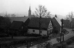
Tschirn is a village in the district of Kronach in Oberfranken (Bavaria, Germany). Located in the Frankenwald mountain range, it incorporates the sections Tschirn, Dobermühle and Gemeindeschneidmühle. The oldest historical record dates 1276.
Towns and municipalities in Kronach | ||
|---|---|---|
References
- ↑ "Fortschreibung des Bevölkerungsstandes". Bayerisches Landesamt für Statistik und Datenverarbeitung (in German). September 2018.
This article is issued from
Wikipedia.
The text is licensed under Creative Commons - Attribution - Sharealike.
Additional terms may apply for the media files.