Knœringue
| Knœringue Knehrige | ||
|---|---|---|
| Commune | ||
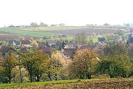 A general view of Knoeringue | ||
| ||
 Knœringue Location within Grand Est region  Knœringue | ||
| Coordinates: 47°33′50″N 7°24′12″E / 47.5639°N 7.4033°ECoordinates: 47°33′50″N 7°24′12″E / 47.5639°N 7.4033°E | ||
| Country | France | |
| Region | Grand Est | |
| Department | Haut-Rhin | |
| Arrondissement | Mulhouse | |
| Canton | Saint-Louis | |
| Intercommunality | Porte du Sundgau | |
| Government | ||
| • Mayor (2008–2014) | André Ueberschlag | |
| Area1 | 4.68 km2 (1.81 sq mi) | |
| Population (2006)2 | 331 | |
| • Density | 71/km2 (180/sq mi) | |
| Time zone | UTC+1 (CET) | |
| • Summer (DST) | UTC+2 (CEST) | |
| INSEE/Postal code | 68168 /68220 | |
| Elevation |
382–452 m (1,253–1,483 ft) (avg. 405 m or 1,329 ft) | |
|
1 French Land Register data, which excludes lakes, ponds, glaciers > 1 km2 (0.386 sq mi or 247 acres) and river estuaries. 2 Population without double counting: residents of multiple communes (e.g., students and military personnel) only counted once. | ||
.svg.png)
Knœringue (Alemannic German: Knehrige; German: Knöringen) is a commune in the Haut-Rhin department in Alsace in north-eastern France.
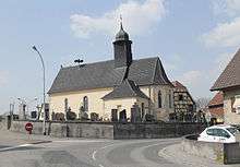
Church of Saint Jacob the Elder
See also
References
| Wikimedia Commons has media related to Knœringue. |
This article is issued from
Wikipedia.
The text is licensed under Creative Commons - Attribution - Sharealike.
Additional terms may apply for the media files.