Jangaon
| Jangaon | |
|---|---|
| Town | |
 Jangaon Location in Telangana, India | |
| Coordinates: 17°43′N 79°11′E / 17.72°N 79.18°ECoordinates: 17°43′N 79°11′E / 17.72°N 79.18°E | |
| Country | India |
| State | Telangana |
| District | Jangaon district |
| Government | |
| • Type | Municipal council |
| • Body | Jangaon Municipality |
| • MLA | Muthireddy Yadagiri Reddy |
| • Member of Parliament | Burra Narsaiah |
| • Municipal Chairman | G Premalatha Reddy |
| Area[1] | |
| • Total | 17.49 km2 (6.75 sq mi) |
| Elevation | 382 m (1,253 ft) |
| Population (2011) | |
| • Total | 52,394 |
| • Density | 3,000/km2 (7,800/sq mi) |
| Languages | |
| • Official | Telugu |
| Time zone | UTC+5:30 (IST) |
| PIN | 506 167 |
| Telephone code | 91–8716 |
| Vehicle registration | TS-27 |
| Website |
jangaonmunicipality |
Jangaon is a town and the district headquarters of Jangaon district in the Indian state of Telangana.[2] It is also the mandal and divisional headquarters of Jangaon mandal and Jangaon revenue division respectively.[3] It is about 85 kilometres from the state capital, Hyderabad.[4] It lies on the National Highway 163.[5]
Geography
Jangaon has an average elevation of 382 metres (1,253 ft).It is Geographically located in the eastern Deccan plateau.
Etymology
The name Jangaon evolved from "jain gaon" which means village of Jains, a religion of India. Kolanpak (kulpak) in the Nalgonda district which is about 20 km from Jangaon is a famous pilgrimage center for Jain people and it has much historical background.
History
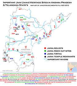
Jain Thirthankara sculptures found in the excavations near the town revealed the existence of Jainism in the Megalithic age.[6] It was also the second capital region of the Kalyani Chalukyas in 11th century.After the demise of the Nayaks rule for 50 years, This region came under Kakatiya dynasty from 1195 CE to 1323 before transferring to Khalji dynasty of Delhi Sultanate under Ala-ud-din Khalji rule. Region was part of the Bahmani Sultanate and then the Sultanate of Golconda Qutb Shahi dynasty in 1512.The Mughal emperor Aurangzeb conquered Golconda in 1687, and it remained part of the Mughal empire.
Qamar-ud-din Khan Asaf Jah I declared sovereignty in 1724 and established Asaf Jahi Dynasty. In 1854 Jangaon area was under administrative region of Bhonagheer Circars shown in map was made by Pharoah and company map.[7] Jangaon mentioned as Zungaon in 1854 map. In 1866 new districts were created all Circars were delimited and merged. Bhonagheer, Davercondah and Nelgoondah Circars merged to form Nalgonda District, but Jangaon area from Bhongir Circar was transferred to Warangal District in 1866, Cherial was made Taluka by adding some parts of Wardannapet region but headquarters was at Jangaon.[8] In 1905 when Princely state of hyderabad sub divided into Four Division namely 1.Aurangabad Division, 2.Gulbarga Division, 3.Gulshanabad Division, 4.Warangal Division.[9][8] During formation divisions again districts were delimited in 1905 Jangaon(Cherial) Taluka and Kodar(Kodad) Sub Taluka transferred to Nalgonda District from Warangal district. Hyderabad State was annexed to Dominion of India by operation polo in 1948, and became an Indian state called as Hyderabad state. In 1948 Jangaon taluka was part of Nalgonda district in Gulshanabad Division of Hyderabad State. Hydearabad State census 1951 Report show Jangaon taluka was most populated taluka of Nalgonda district with total population of 2,91,165 with area of 1403.9 sq km consist of more than 200 inhabited towns and villages.Aler, Cheriyal, and Kolanpak was under Jangaon taluka before they were transferred to other districts.
In 1953,there was shuffling of areas shifting of some villages from one taluka to the other. Subsequently, when Warangal district was divided to facilitate administrative control and on October 1, 1953 the Khammam district was formed.[9] Khammam, Yellandu, Madhira, Burugunpahad and Palavancha talukas have been made part of it. Warangal, Mulugu, Mahabubabad, Pakala(Narsampet) remained in Warangal district. But again Parkaala from Karimnagar district and Jangaon taluka from Nalgonda district have become part of Warangal district living back Nalgonda, Miryalguda, Deverkonda, Bhongir, Ramannapet, Suryapet, and Huzurnagar to Nalgonda district. After these changes in 1953, few villages of Jangaon taluka went to Medak district and some remained in Nalgonda district.
During resigm of Marri Chenna Reddy in 1979 Jangaon taluka was split into Cherial, Kodakandla and Jangaon talukas. In 1985 when N. T. Rama Rao introduces mandal system Jangaon taluka further divided in to Jangaon, Raghunathpalle, Lingalaghanpur and Devaruppula Mandals
In 2016 on 11th Oct, Jangaon is made as the district headquarters along with 21 newly formed district in Telangana. Warangal district was divided in to Five districts are Warangal Urban district, Warangal Rural district, Jangaon district, Jayashankar district and Mahabubabad district. The Jangaon district was formed with mostly old Jangaon Revenue division except Maddur, Cherial and Newly formed Komuravelli Mandals Which were transferred to Newly formed Siddipet district, Ghanpur and Zaffergadh from Warangal Revenue division and Gundala of Nalgonda district were merged with Jangaon district.[10]
Demographics
| Jangaon Town population | |||
|---|---|---|---|
| Census | Pop. | %± | |
| 1901 | 1,696 | — | |
| 1911 | 3,537 | 108.5% | |
| 1921 | 4,158 | 17.6% | |
| 1931 | 8,078 | 94.3% | |
| 1941 | 7,036 | -12.9% | |
| 1951 | 11,259 | 60.0% | |
| 1961 | 11,927 | 5.9% | |
| 1971 | 16,866 | 41.4% | |
| 1981 | 25,112 | 48.9% | |
| 1991 | 34,305 | 36.6% | |
| 2001 | 43,996 | 28.2% | |
| 2011 | 52,394 | 19.1% | |
| Sources:[12] | |||
As of 2011 census of India, the city had a population of 52,394 with 12,276 households. The total population constitute, 2,596 males and 2,527 females —a sex ratio of 958 females per 1000 males. 5,123 children are in the age group of 0–6 years, of which 7,347 are boys and 6,993 are girls—a ratio of 952 per 1000. The average literacy rate stands at 82.39% with 38,948 literates.[1]
Majority of the population constitute Hindus with 86.08% and the rest of them are minorities such as, Muslims (11.55%), Christians (1.83%), Sikhs (0.23%), Buddhists (0.02%) and 0.27% with no religion stated.[11]
Climate
Jangaon experiences a tropical kind of climate. It's a drought prone area according to Geological survey. Experiences very hot summers, moderate winters and rains less than the average precipitation.
The climate in Jangaon is referred to as a local steppe climate. During the year, there is little rainfall in Jangaon. The climate here is classified as BSh by the Köppen-Geiger system. The average annual temperature is 27.3 °C in Jangaon. In a year, the average rainfall is 788 mm. The least amount of rainfall occurs in January. The average in this month is 1 mm. Most precipitation falls in July, with an average of 183 mm.
The temperatures are highest on average in May, at around 33.9 °C. In December, the average temperature is 22.0 °C. It is the lowest average temperature of the whole year. The variation in the precipitation between the driest and wettest months is 182 mm. The average temperatures vary during the year by 11.9 °C.
| Climate data for Jangaon Town | |||||||||||||
|---|---|---|---|---|---|---|---|---|---|---|---|---|---|
| Month | Jan | Feb | Mar | Apr | May | Jun | Jul | Aug | Sep | Oct | Nov | Dec | Year |
| Average high °C (°F) | 29.7 (85.5) |
32.4 (90.3) |
36.0 (96.8) |
38.4 (101.1) |
40.4 (104.7) |
35.9 (96.6) |
31.1 (88) |
30.8 (87.4) |
31.0 (87.8) |
31.4 (88.5) |
29.6 (85.3) |
28.8 (83.8) |
33 (91.3) |
| Average low °C (°F) | 16.3 (61.3) |
18.6 (65.5) |
21.7 (71.1) |
25.0 (77) |
27.5 (81.5) |
25.8 (78.4) |
23.7 (74.7) |
23.6 (74.5) |
23.2 (73.8) |
21.4 (70.5) |
17.6 (63.7) |
15.2 (59.4) |
21.6 (71) |
| Average precipitation mm (inches) | 1 (0.04) |
2 (0.08) |
5 (0.2) |
21 (0.83) |
17 (0.67) |
119 (4.69) |
183 (7.2) |
167 (6.57) |
168 (6.61) |
78 (3.07) |
21 (0.83) |
8 (0.31) |
790 (31.1) |
| Source: [13] | |||||||||||||
Governance
Civic administration
Jangaon Municipality is the civic body that oversees the civic needs of the town. It was constituted in the year 1953 as a third grade municipality. It was upgraded to second grade in the year 2010 with 28 municipal wards. The jurisdiction of the civic body is spread over an area of 17.49 km2 (6.75 sq mi).[4][14]
Law and order
Deputy Commissioner of Police Jangaon are responsible for maintaining law and order in Town and Jangaon district areas. Jangaon have Senior Civil Judge’s Court, and Prl. Junior Civil Judge’s Court for maintaining law and order.
Healthcare
The 100-bed Government Area Hospital Jangaon is the largest hospital in the town for healthcare.[15]
Culture

Kolanupaka temple, a religious destination for the Jains.[6]
Townscape
The Champak Hills located 6 km (3.7 mi), is a place of rich filled flora and fauna.[16]
Transport
Public transport
The TSRTC has a bus depot in the town and provides public transport.[17]
Roadways
Jangaon has road and rail connectivity.[18] The town has a total road length of 124.75 km (77.52 mi), of which 73.50 km (45.67 mi) of cement concrete roads, 15.25 km (9.48 mi) of bituminous tar roads and 36.00 km (22.37 mi) of water bound macadam road.[19] National Highway 163, connecting Hyderabad and Bhopalpatnam Road, pass through the town.[20] A new National highway 365B connecting Sircilla–Siddipet–Jangaon–Suryapet connects it with different districts of the state.[21].
Railway
Jangaon railway station provides rail connectivity to the town and is under the jurisdiction of the Secunderabad railway division of South Central Railway zone.[22] It was constructed by Nizam's Guaranteed State Railway in 1879, This railway line connected Hyderabad to Warangal later extended to Bezawada.[23] Falaknuma–Jangaon MEMU is a suburban train that connects the town with the state capital.[24]
Education
The town has 38,948 literates with 21,722 males, 17,226 females and the literacy rate of 82.39%.[1] The primary and secondary school education is imparted by government and private schools, under the School Education Department of the state, assisted by State Institute of Educational Technology.[25] The municipal limits of the town has a total of 14 government and 38 private schools.[19]
The Higher Education Department of the state oversees the undergraduate and postgraduate education.[26] The town has four government and fifteen private run colleges.[19] This includes, APSW Boys Residential Junior College, a social welfare college; 5 private unaided colleges and a co-operative junior college as well.[27] There exists one residential college under APRJC, ten private aided, two co-operative and many private aided colleges.[27] A.B.V.Government Degree College is the autonomous college, affiliated to Kakatiya University approved under Universities Grant Commission scheme.[28]
See also
References
- 1 2 3 "District Census Handbook – Warangal" (PDF). Census of India. pp. 14, 54–55. Retrieved 5 April 2017.
- ↑ "Jangaon district" (PDF). Official website of Jangaon district. Retrieved 20 March 2017.
- ↑ "Maps – THE OFFICIAL WEBSITE OF JANGAON DISTRICT". jangaon.telangana.gov.in. Retrieved 12 April 2017.
- 1 2 "Basic Information of Municipality | Jangaon Municipality". jangaonmunicipality.in. Retrieved 5 April 2017.
- ↑ "OpenStreetMap | Relation: National Highway 163 (3249370)". OpenStreetMap. Retrieved 12 April 2017.
- 1 2 "Jain sculptures of Vedic times found in Telangana". Deccan Chronicle. 18 December 2016. Retrieved 6 April 2017.
- ↑ "1854 Pharoah and Company Map of the Hyderabad, Sangareddy and Nalgonda Districts of Telangana, India".
- 1 2 Yazdani, Ghulam. "Hyderabad State". Atlantic Publishers & Distri – via Google Books.
- 1 2 "Know Your Corporation".
- ↑ "New districts". Andhra Jyothy.com. 8 October 2016. Retrieved 8 October 2016.
- 1 2 "Jangaon Town Population Census 2011 – Andhra Pradesh".
- ↑ Gopi, K.N (1978). Process of urban fringe development: A model. Concept Publishing Company. p. 25. Retrieved 6 August 2013.
- ↑ http://en.climate-data.org/location/441805/
- ↑ "Urban Local Body Information" (PDF). Directorate of Town and Country Planning. Government of Telangana. Archived from the original (PDF) on 15 June 2016. Retrieved 28 June 2016.
- ↑ "Jangaon district" (PDF). Official website of Jangaon district. Retrieved 20 March 2017.
- ↑ "The Hindu : Life Hyderabad : Perfect setting". The Hindu. Retrieved 6 April 2017.
- ↑ "Depots". www.tsrtc.telangana.gov.in. Retrieved 6 April 2017.
- ↑ "Town map | Jangaon Municipality". jangaonmunicipality.in. Retrieved 12 April 2017.
- 1 2 3 "Public services/amenities | Jangaon Municipality". jangaonmunicipality.in. Retrieved 12 April 2017.
- ↑ "National Highways in Telangana state". Roads and Buildings Department - Government of Roads. Retrieved 12 April 2017.
- ↑ "NH plan hits roadblocks in Telangana". The Hans India. Retrieved 12 April 2017.
- ↑ "Jurisdiction map of Secunderabad Division". South Central Railway. Retrieved 6 April 2017.
- ↑ "He was way ahead of his time". Deccan Herald. Retrieved 12 April 2017.
- ↑ Mishra, Shiv Kumar. "67278/Jangaon Falaknuma MEMU - Jangaon/ZN to Falaknuma/FM SCR/South Central Zone - Railway Enquiry". indiarailinfo.com. Retrieved 12 April 2017.
- ↑ "Telangana State Portal School Education (SE Wing)". www.telangana.gov.in. Retrieved 12 April 2017.
- ↑ "Telangana State Portal Higher Education". www.telangana.gov.in. Retrieved 12 April 2017.
- 1 2 "List of colleges in Guntur district" (PDF). Board of Intermediate Education. Retrieved 27 September 2016.
- ↑ "Autonomous colleges list" (PDF). Universities Grants Commission. p. 44. Retrieved 12 April 2017.