Fort Stockton–Pecos County Airport
| Fort Stockton–Pecos County Airport Gibbs Army Airfield | |||||||||||||||||||||||
|---|---|---|---|---|---|---|---|---|---|---|---|---|---|---|---|---|---|---|---|---|---|---|---|
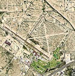 2006 USGS Airphoto | |||||||||||||||||||||||
| Summary | |||||||||||||||||||||||
| Airport type | Public | ||||||||||||||||||||||
| Location | Pecos County, near Fort Stockton, Texas | ||||||||||||||||||||||
| Elevation AMSL | 3,011 ft / 917.8 m | ||||||||||||||||||||||
| Coordinates | 30°54′54.90″N 102°54′46.0″W / 30.9152500°N 102.912778°WCoordinates: 30°54′54.90″N 102°54′46.0″W / 30.9152500°N 102.912778°W | ||||||||||||||||||||||
| Map | |||||||||||||||||||||||
 KFST Location | |||||||||||||||||||||||
| Runways | |||||||||||||||||||||||
| |||||||||||||||||||||||
Fort Stockton–Pecos County Airport (IATA: FST, ICAO: KFST) is two miles NW of Fort Stockton, Texas, United States and is owned and operated by Pecos County, Texas.
History
The airport opened as Gibbs Field , or Fort Stockton Field and was used by the United States Army Air Forces as a training base during World War II.
Opened on 1 June 1942 with two 2,500' turf runways. Began training United States Army Air Corps flying cadets under contract to Pacific Air School Ltd. Assigned to United States Army Air Forces Gulf Coast Training Center (later Central Flying Training Command) as a primary (level 1) pilot training airfield. had two local auxiliary airfields for emergency and overflow landings. Flying training was performed with Fairchild PT-19s as the primary trainer. Also had several PT-17 Stearmans and a few P-40 Warhawks assigned.
Inactivated on 12 March 1944 with the drawdown of AAFTC's pilot training program. Declared surplus and turned over to the Army Corps of Engineers on 30 September 1945. Eventually discharged to the War Assets Administration (WAA) and became a civil airport.
Airline flights (Trans-Texas DC-3s) ended in 1960.
See also
References
![]()
| Wikimedia Commons has media related to Fort Stockton Field. |
- Shaw, Frederick J. (2004), Locating Air Force Base Sites History’s Legacy, Air Force History and Museums Program, United States Air Force, Washington DC, 2004.
- Manning, Thomas A. (2005), History of Air Education and Training Command, 1942–2002. Office of History and Research, Headquarters, AETC, Randolph AFB, Texas ASIN: B000NYX3PC
- AirNav.Com – Fort Stockton–Pecos County Airport (KFST)
- Thole, Lou (1999), Forgotten Fields of America : World War II Bases and Training, Then and Now – Vol. 2. Publisher: Pictorial Histories Pub, ISBN 1-57510-051-7
External links
- FAA Terminal Procedures for FST, effective October 11, 2018
- Resources for this airport:
- FAA airport information for FST
- AirNav airport information for FST
- FlightAware airport information and live flight tracker
- SkyVector aeronautical chart for FST
| Flying Training |
|  | ||||
|---|---|---|---|---|---|---|
| Technical Training |
| |||||