Texas State Highway 18
| ||||
|---|---|---|---|---|
 | ||||
| Route information | ||||
| Maintained by TxDOT | ||||
| Length | 83.5 mi[1] (134.4 km) | |||
| Existed | 1958[1]–present | |||
| Major junctions | ||||
| South end |
| |||
|
| ||||
| North end |
| |||
| Location | ||||
| Counties | Pecos, Ward, Winkler | |||
| Highway system | ||||
| ||||

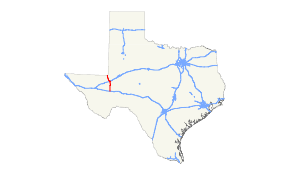
State Highway 18, or SH 18, is a state highway in the U.S. state of Texas maintained by the Texas Department of Transportation (TxDOT) that runs from Fort Stockton in western Texas to the Texas-New Mexico state line between Kermit and Jal, New Mexico. This route was designated in 1958 over the northern half of what was previously SH 82.
Route description
SH 18 begins at Fort Stockton at an intersection with Business Interstate 10 and US 285. Heading north, it soon intersects Interstate 10 and US 67, which is in concurrency with the interstate. It continues traveling north through oil fields and rural ranch land. 25 miles north of Fort Stockton, SH 18 intersects Farm to Market Road 1450. The highway continues north and enters Grandfalls. In Grandfalls, the highway intersects SH 329 and Farm to Market Road 11. The highway continues north, intersecting Farm to Market Road 1776, Farm to Market Road 1233, Loop 464, and Interstate 20 before reaching Monahans. In Monahans SH 18 intersects Business Interstate 20 and continues northwest, making a second interchange with SH 464. Eight miles northwest of Monahans, the highway intersects Farm to Market Road 1219. SH 18 continues in a slightly northwest direction toward Kermit, making an interchange with Farm to Market Road 1232 along the way. In Kermit the highway has an intersection with SH 302 and a slight western concurrency with SH 115 before continuing to head northwest out of Kermit. The highway ends at the New Mexico border, where the road becomes New Mexico State Highway 18.
History
The current routing was originally planned as State Highway 17 as recently as 1922. By 1926, the SH 17 designation has been transferred to the routing of SH 17A, while this route was renumbered as SH 82. On February 27, 1958, the route was again renumbered as SH 18, to coordinate with the connecting New Mexico Highway 18 to the north.

SH 18 was one of the first 25 Texas state routes proposed on June 21, 1917, overlaid on the Albany-Bronco Highway.[2] The original proposal was a route through the Southern Plains from Bronco in Yoakum County to Lubbock, then southeast to Albany. On December 20, 1917, SH 18 had extended southeast to Waco, replacing SH 36.[3]On August 21, 1923, the route had been changed significantly. The eastern section of the route from Spur to Albany was intact, but the previous westward route veered northward instead to Turkey, with the old route being renumbered to SH 53.[4] The section southeast of Albany became part of the new SH 67.[5] On September 17, 1923, SH 18 extended northeast to Memphis.[6] On November 19, 1923, the section of SH 18 from Turkey to Memphis was cancelled, and SH 23 was rerouted east to Estelline instead.[7] On July 13, 1925, a split from Aspermont to Anson was added.[8] By 1926, this split was cancelled. On October 22, 1935, SH 18 Spur was designated through Roaring Springs.[9] On December 22, 1936, the section from Turkey to Estelline became part of SH 86.[10] On May 24, 1938, it was extended farther northward to the Oklahoma border, overtaking SH 88 from Turkey to Oklahoma.[11] On January 6, 1939, two SH 18 Spur routes were designated to Spur and Peacock.[12] On September 26, 1939, the portion from Matador to Albany was reassigned to U.S. Highway 62, SH 70, and U.S. Highway 380. SH 18 Spur was renumbered as Spur 42. SH 18 was extended further north to Perryton on May 21, 1940, and on October 10, 1947 became part of SH 70 when SH 70 was extended into Matador from the south due to the rerouting of U.S. Highway 62 off of this road.

SH 18A was an alternate route along SH 18 proposed on August 19, 1918. It covered a shorter route between Spur and Crosbyton during the 1920s.[13]

SH 18B was a more southerly route proposed on January 23, 1919.[14] It was to branch off from SH 18 in Brownfield, travel southeast to Lamesa, then run due east to Albany. It is unknown if it had been built before being renumbered on August 21, 1923 as SH 83.[15]
Major intersections
| County | Location | mi[16] | km | Destinations | Notes |
|---|---|---|---|---|---|
| Pecos | Fort Stockton | 0.0 | 0.0 | Southern terminus | |
| 0.9 | 1.4 | I-10 exit 259B | |||
| | |||||
| | |||||
| Ward | Grandfalls | ||||
| 31.9 | 51.3 | ||||
| Royalty | |||||
| | |||||
| | |||||
| | 46.0 | 74.0 | |||
| Monahans | 48.6 | 78.2 | I-20 exit 80 | ||
| 50.0 | 80.5 | ||||
| | 52.5 | 84.5 | |||
| | |||||
| Winkler | | ||||
| Kermit | 72.3 | 116.4 | |||
| 73.1 | 117.6 | south end of SH 115 overlap | |||
| 73.3 | 118.0 | north end of SH 115 overlap | |||
| | |||||
| | 83.7 | 134.7 | New Mexico state line | ||
| 1.000 mi = 1.609 km; 1.000 km = 0.621 mi | |||||
See also


References
- 1 2 Transportation Planning and Programming Division (n.d.). "State Highway No. 18". Highway Designation Files. Texas Department of Transportation. Retrieved August 5, 2010.
- ↑ (PDF) https://publicdocs.txdot.gov/minord/MinuteOrderDocLib/003676699.pdf. Missing or empty
|title=(help) - ↑ (PDF) https://publicdocs.txdot.gov/minord/MinuteOrderDocLib/003676746.pdf. Missing or empty
|title=(help) - ↑ (PDF) https://publicdocs.txdot.gov/minord/MinuteOrderDocLib/003676878.pdf. Missing or empty
|title=(help) - ↑ (PDF) https://publicdocs.txdot.gov/minord/MinuteOrderDocLib/003676878.pdf. Missing or empty
|title=(help) - ↑ (PDF) https://publicdocs.txdot.gov/minord/MinuteOrderDocLib/003676879.pdf. Missing or empty
|title=(help) - ↑ (PDF) https://publicdocs.txdot.gov/minord/MinuteOrderDocLib/003676881.pdf. Missing or empty
|title=(help) - ↑ (PDF) https://publicdocs.txdot.gov/minord/MinuteOrderDocLib/003676910.pdf. Missing or empty
|title=(help) - ↑ (PDF) https://publicdocs.txdot.gov/minord/MinuteOrderDocLib/003673876.pdf. Missing or empty
|title=(help) - ↑ (PDF) https://publicdocs.txdot.gov/minord/MinuteOrderDocLib/003673889.pdf. Missing or empty
|title=(help) - ↑ (PDF) https://publicdocs.txdot.gov/minord/MinuteOrderDocLib/003676244.pdf. Missing or empty
|title=(help) - ↑ (PDF) https://publicdocs.txdot.gov/minord/MinuteOrderDocLib/003676255.pdf. Missing or empty
|title=(help) - ↑ (PDF) https://publicdocs.txdot.gov/minord/MinuteOrderDocLib/003676771.pdf. Missing or empty
|title=(help) - ↑ (PDF) https://publicdocs.txdot.gov/minord/MinuteOrderDocLib/003676788.pdf. Missing or empty
|title=(help) - ↑ (PDF) https://publicdocs.txdot.gov/minord/MinuteOrderDocLib/003676878.pdf. Missing or empty
|title=(help) - ↑ Google (August 19, 2010). "Route of SH 18" (Map). Google Maps. Google. Retrieved August 19, 2010.
External links
Route map:
![]()