U.S. Route 322 in Pennsylvania
| ||||
|---|---|---|---|---|
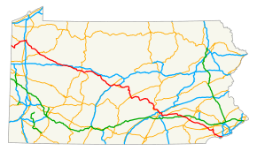 Route highlighted in red | ||||
| Route information | ||||
| Maintained by PennDOT | ||||
| Length | 370 mi[1] (595 km) | |||
| Major junctions | ||||
| West end |
| |||
|
| ||||
| East end |
| |||
| Location | ||||
| Counties | Crawford, Mercer, Venango, Clarion, Jefferson, Clearfield, Centre, Mifflin, Juniata, Perry, Dauphin, Lebanon, Lancaster, Chester, Delaware | |||
| Highway system | ||||
| ||||

U.S. Route 322 (US 322) is a spur of U.S. Route 22, running from Cleveland, Ohio east to Atlantic City, New Jersey. In the U.S. state of Pennsylvania, the route runs from the Ohio border in West Shenango Township southeast to the Commodore Barry Bridge over the Delaware River in Chester, at which point the route crosses into New Jersey. The route passes near several cities, including DuBois, State College, and Harrisburg.
Route description
In Pennsylvania, US 322 is signed as 28th Division Highway, in honor of the 28th Infantry Division.[2] The route enters Pennsylvania taking a northeasternly course. In Meadville, US 322 overlaps U.S. Route 6 and U.S. Route 19. Southeast of Meadville, the highway runs generally southeast through Crawford, Venango and Clarion Counties. Once leaving Clarion borough, US 322 interchanges I-80, at exit 70. From I-80, it continues on a solid east–west routing crossing Jefferson County. The route overlaps U.S. Route 219 near the northern terminus of U.S. Route 119, south of Du Bois. East of US 219, the route takes a southward turn to traverse Moshannon State Forest, before taking an east–west alignment. From Clearfield to U.S. Route 220, the highway runs southeast and is partly divided.[2]
In the State College area, the current alignment of US 322 overlaps Interstate 99 and US 220 for 12 miles (19 km)[3] Northeast of Port Matilda, Interstate 99, US 220, and US 322 depart the Appalachian Thruway via an interchange and proceed east on the 28th Division Highway while the Thruway continues to the northeast as US 220 Alternate.[4]
West of State College, the 28th Division Highway becomes the Mount Nittany Expressway after intersecting with Scotia Road and North Atherton Street (Business US 322, which goes through downtown State College). The I-99/US 220/US 322 overlap ends at a complex interchange north of downtown State College.[2][5]
East of the overlap, US 322 continues southeastward through State College and its immediate suburbs on the Mount Nittany Expressway. After three exits, US 322 reverts to an at-grade highway two miles east of State College in Boalsburg, merging with US 322 Business and proceeding eastward along Boal Avenue as the route exits the State College area. Between Boalsburg and Lewistown, the highway traverses Tussey Mountain and Stone Mountain, in the Rothrock State Forest, as it turns to the south.[6][7]
Between Potters Mills and Lewistown, US 322 is a limited-access road. Near Lewistown, it briefly overlaps U.S. Route 522 and begins a long overlap with US 22. South of Lewistown, US 22/US 322 enters the Lewistown Narrows, an 8-mile (13 km) stretch of road through the Juniata River water gap in Shade Mountain. Construction to convert this section of the highway from a two-lane highway to a divided, limited-access four-lane highway was completed in December 2007,[8] and it includes building the longest mechanically stabilized earth wall in the U.S.[9] The highway exits the narrows in Arch Rock, traverses Juniata County and Perry County, and crosses the Tuscarora Mountain through a water gap on a southeastward course along the banks of the Juniata River. After crossing the Susquehanna at Clarks Ferry (coinciding with the Appalachian Trail), the freeway runs south and parallels the river for 15 miles (24 km) before entering the Harrisburg Area.[10][11]
North of downtown Harrisburg, the US 22/322 overlap interchanges with Interstate 81 at exit 67. While US 22 continues through the interchange and heads into downtown, US 322 departs US 22 and joins I-81 northbound. I-81 and US 322 remain concurrent for three miles (5 km) to exit 70, where US 322 exits, following Interstate 83, which has its northern terminus at the interchange, south through the innermost suburbs of Harrisburg.[12][13] After two exits, US 322 departs I-83 at the Eisenhower Interchange (exit 47), following Paxton Street east, returning to an at-grade roadway after one exit, toward Hummelstown.[2][14] West of that borough, US 322 becomes a freeway once again, becoming the Hummelstown Bypass after crossing Fiddlers Elbow Road. The route runs south of Hummelstown, interchanging with two local roads before meeting the eastern terminus of Pennsylvania Route 39 and the western terminus of U.S. Route 422 at an interchange midway between Hummelstown and Hershey.[15]
As the freeway ends (road continues ahead as US 422), US 322 exits and heads east on the at-grade West Governor Road as it passes south of Hershey. East of the Hershey area, the route runs eastward via the scenic Horseshoe Pike traversing Lebanon County. The Horseshoe Pike portion ends west of Cornwall, where US 322 bypasses the town (during an overlap with PA 72).[16] East of the bypass, the route becomes grade-leveled again, enters Lancaster County and passes over the Pennsylvania Turnpike (I-76). This stretch runs eastward, again known as the 28th Division Highway. East of Ephrata, US 322 interchanges U.S. Route 222 and continues southeastward through the Pennsylvania Dutch Country of eastern Lancaster County, which is home to many Amish farms.[17][18] In this area, the route intersects PA 23 in Blue Ball, and then reverts to the name Horseshoe Pike before crossing PA 10 in Honey Brook after entering Chester County. In Downingtown, US 322 interchanges US 30.[19] After passing under US 30 it continues into Downingtown as Manor Ave before intersecting US 30 Business/Lancaster Ave. The route turns left at the intersection and runs concurrent US 30 Business for a block while crossing the Brandywine Creek. The route then turns right at the next intersection onto Brandywine Ave as it exits the borough and becomes Downingtown Pike.
Where the highway approaches the West Chester area, it bypasses the borough via West Chester Bypass. At the end of the at-grade bypass, the eastbound lane of US 322 merges onto U.S. Route 202 southbound to begin an overlap. After three exits, the US 202/US 322 overlap becomes grade leveled running north–south.[20] South of West Chester, the overlap is a major divided highway in Chester County and then entering Delaware County. In Concord Township, US 322 turns east onto U.S. Route 1 and leaves U.S. Route 202 at Painters' Crossroad. One mile conjoined with US 1 east of US 202, US 322 leaves US 1 via a turn southeastward to become the Conchester Highway. Approaching Chester, the route has three exits (one with PA 452, Bethel Road at the CSX rail line, and Highland Avenue) before beginning an overlap with Interstate 95, at exit 3A. The overlap with I-95 is a brief one, where US 322 leaves I-95, at exit 4, and crosses the Delaware River to enter New Jersey via the Commodore Barry Bridge.[21]
History
In 1937, US 322 replaced PA 5 along the Lakes-to-Sea Highway between Harrisburg and West Chester.[22]
To decrease congestion and improve safety, the Pennsylvania Department of Transportation began a project in 2014 to reconstruct US 322 from the Centre/Mifflin county line to the route's interchange with PA 144, at a cost of about $93 million. On March 30, 2018, the Sand Mountain Road interchange in Spring Mills opened, replacing the at-grade intersection. The bulk of the cost of the project is related to an extension of the four-lane portion of US 322 through Potters Mills Gap and a new interchange with PA 144, which is scheduled to be completed by October 2020.[23][24]
Major intersections
| County | Location | mi | km | Exit | Destinations | Notes |
|---|---|---|---|---|---|---|
| Crawford | West Shenango Township | 0.00 | 0.00 | Ohio state line | ||
| Mercer | Jamestown | 5.3 | 8.5 | West end of PA 58 concurrency | ||
| 5.6 | 9.0 | East end of PA 58 concurrency | ||||
| Crawford | West Fallowfield Township | 12.0 | 19.3 | West end of PA 18 concurrency | ||
| Conneaut Lake | 17.3 | 27.8 | West end of US 6/PA 285 concurrency | |||
| 17.4 | 28.0 | East end of PA 285 concurrency | ||||
| 18.3 | 29.5 | East end of PA 18 concurrency | ||||
| Crawford Township | 22.9 | 36.9 | West end of US 19 concurrency, southern terminus of PA 98 | |||
| 24.1 | 38.8 | I-79 exit 147; interchange. | ||||
| Meadville | 24.7 | 39.8 | Southern terminus of PA 102 | |||
| 25.8 | 41.5 | East end of US 6/19 concurrency | ||||
| Wayne Township | 36.1 | 58.1 | ||||
| Venango | Sugarcreek Township | 46.2 | 74.4 | Southern terminus of PA 427 | ||
| Franklin | 51.8 | 83.4 | Southern terminus of PA 417 | |||
| 52.3 | 84.2 | West end of US 62/PA 8 concurrency | ||||
| 52.7 | 84.8 | East end of US 62/PA 8 concurrency | ||||
| Cranberry Township | 60.0 | 96.6 | Southern terminus of PA 257 | |||
| Rockland Township | 65.3 | 105.1 | Northern terminus of PA 38 | |||
| Clarion | Ashland Township | 68.9 | 110.9 | Eastern terminus of PA 338 | ||
| Shippenville | 75.3 | 121.2 | West end of PA 208 concurrency | |||
| 75.5 | 121.5 | East end of PA 208 concurrency | ||||
| Paint Township | 77.4 | 124.6 | ||||
| Clarion | 80.5 | 129.6 | Eastern terminus of PA 68 | |||
| Clarion Township | 88.4 | 142.3 | Interchange | |||
| Jefferson | Corsica | 90.7 | 146.0 | West end of PA 949 concurrency | ||
| East end of PA 949 concurrency | ||||||
| Brookville | 96.3 | 155.0 | West end of PA 28/36 concurrency | |||
| 97.1 | 156.3 | East end of PA 36 concurrency | ||||
| 98.3 | 158.2 | East end of PA 28 concurrency | ||||
| Reynoldsville | 109.0 | 175.4 | Southern terminus of PA 950 | |||
| 109.5 | 176.2 | Northern terminus of PA 310 | ||||
| Clearfield | Sandy Township | 115.5 | 185.9 | |||
| 117.0 | 188.3 | West end of US 219 concurrency | ||||
| Brady Township | 119.8 | 192.8 | Eastern terminus of PA 410 | |||
| 119.9 | 193.0 | East end of US 219 concurrency | ||||
| Clearfield | 130.6 | 210.2 | West end of PA 153 concurrency | |||
| Lawrence Township | 136.7 | 220.0 | East end of PA 153/879 concurrency | |||
| 138.2 | 222.4 | Interchange | ||||
| Bradford Township | 142.8 | 229.8 | Southern terminus of PA 970 | |||
| Philipsburg | 153.0 | 246.2 | West end of PA 53 concurrency | |||
| Centre | 153.2 | 246.6 | East end of PA 53 concurrency | |||
| 154.2 | 248.2 | |||||
| Worth Township | West end of freeway | |||||
| 165.4 | 266.2 | West end of I-99/US 220 concurrency; I-99 exit 62 | ||||
| Patton Township | 171.4 | 275.8 | 68 | Grey's Woods, Waddle | Exit numbers follow I-99 | |
| 172.2 | 277.1 | 69 | Eastbound exit and westbound entrance | |||
| 172.4 | 277.5 | Valley View Drive – Park Forest | Westbound exit and eastbound entrance | |||
| 173.2 | 278.7 | 71 | Toftrees, Woodycrest | |||
| College Township | 175.8 | 282.9 | — | East end of I-99/US 220 concurrency; I-99 exit 73 | ||
| 176.1 | 283.4 | — | Innovation Park, Penn State University | Access to Beaver Stadium and Bryce Jordan Center | ||
| 177.4 | 285.5 | — | ||||
| Harris Township | 180.0 | 289.7 | — | Eastbound exit and westbound entrance | ||
| East end of freeway | ||||||
| 181.2 | 291.6 | Interchange; westbound exit and eastbound entrance | ||||
| Potter Township | 189.7 | 305.3 | Southern terminus PA 144 | |||
| Mifflin | Armagh Township | West end of freeway | ||||
| 198.4 | 319.3 | Milroy | ||||
| Brown Township | 200.9 | 323.3 | Northern terminus of PA 655 | |||
| Derry Township | 204.2 | 328.6 | Yeagertown, Burnham | |||
| 205.3 | 330.4 | West end of US 22/US 522 concurrency | ||||
| Lewistown | 205.5 | 330.7 | Electric Avenue | Eastbound exit from US 22/US 522 exit | ||
| 206.1 | 331.7 | East end of US 522 concurrency | ||||
| 206.6 | 332.5 | East Charles Street | Eastbound exit, westbound entrance | |||
| Granville Township | 208.4 | 335.4 | Westbound exit, eastbound entrance | |||
| Juniata | Fermanagh Township | 216.0 | 347.6 | Arch Rock Road | ||
| 219.2 | 352.8 | |||||
| Walker Township | 221.1 | 355.8 | ||||
| Delaware Township | 228.9 | 368.4 | ||||
| 230.4 | 370.8 | Pfoutz Valley Road | Westbound exit, eastbound entrance | |||
| Perry | Millerstown | 234.2 | 376.9 | |||
| Newport | 238.7 | 384.2 | ||||
| Howe Township | 242.5 | 390.3 | Midway | Westbound exit, eastbound entrance | ||
| Watts Township | 245.1 | 394.5 | Watts | Left exit eastbound; Right exit westbound | ||
| 247.0 | 397.5 | Amity Hall | ||||
| Dauphin | Reed Township | 247.2 | 397.8 | |||
| East end of freeway | ||||||
| 248.6 | 400.1 | Eastern terminus of PA 849; no access from PA 849 to westbound US 22/322 | ||||
| West end of freeway | ||||||
| Susquehanna River | Clarks Ferry Bridge | |||||
| Reed Township | 249.0 | 400.7 | Interchange, Southern terminus of PA 147 | |||
| Middle Paxton Township | 251.0 | 403.9 | Interchange, Western terminus of PA 325 | |||
| Dauphin | 254.4 | 409.4 | Interchange, Southern terminus of PA 225 | |||
| 255.4 | 411.0 | Dauphin Boro, Stony Creek | Westbound exit | |||
| Susquehanna Township | 256.8 | 413.3 | ||||
| Harrisburg | 258.7 | 416.3 | ||||
| 260.7 | 419.6 | Interchange, west end of I-81 concurrency, east end of US 22 concurrency; I-81 exit 67 | ||||
| Susquehanna Township | 262.3 | 422.1 | 69 | Progress Avenue | Exit number follows I-81 | |
| Lower Paxton Township | 263.3 | 423.7 | 51B | Exit numbers follow I-83; east end of I-81 concurrency; northern terminus of I-83; west end of I-83 concurrency; I-81 exit 70, I-83 exit 51A | ||
| 264.0 | 424.9 | 43 | ||||
| 265.2 | 426.8 | 48 | Union Deposit Road | |||
| Swatara Township | 266.6 | 429.1 | — | East end of I-83 concurrency; eastbound left exit and westbound left entrance; I-83 exit 47 | ||
| — | Derry Street | |||||
| — | Eastbound exit only | |||||
| — | Eisenhower Boulevard | Eastbound left exit and westbound left entrance | ||||
| — | Westbound left exit and eastbound left entrance; I-83 exit 46B | |||||
| — | Westbound left exit and eastbound entrance; I-283 exit 3C | |||||
| 268.0 | 431.3 | — | Penhar Drive | |||
| East end of freeway | ||||||
| Hummelstown | West end of freeway | |||||
| 272.9 | 439.2 | Hummelstown | ||||
| Derry Township | 274.3 | 441.4 | Interchange, western terminus of eastern segment US 422, eastern terminus of PA 39 | |||
| East end of freeway | ||||||
| 276.4 | 444.8 | |||||
| Lebanon | South Londonderry Township | 280.5 | 451.4 | |||
| South Annville Township | 284.9 | 458.5 | West end of PA 241 concurrency | |||
| 285.1 | 458.8 | Southern terminus of PA 934 | ||||
| 285.9 | 460.1 | East end of PA 241 concurrency | ||||
| West Cornwall Township | 287.2 | 462.2 | Southern terminus of PA 419 | |||
| West end of freeway | ||||||
| 288.0 | 463.5 | Westbound exit, eastbound entrance, west end of PA 72 concurrency | ||||
| 288.4 | 464.1 | Southern terminus of PA 117 | ||||
| 289.1 | 465.3 | Eastbound exit, westbound entrance, east end of PA 72 concurrency | ||||
| East end of freeway | ||||||
| Lancaster | Elizabeth Township | 296.9 | 477.8 | |||
| Ephrata | 303.9 | 489.1 | Interchange, access to WellSpan Ephrata Community Hospital | |||
| Ephrata Township | 306.4 | 493.1 | Interchange | |||
| East Earl Township | 312.8 | 503.4 | ||||
| 313.8 | 505.0 | West end of PA 897 concurrency | ||||
| 313.9 | 505.2 | East end of PA 897 concurrency | ||||
| Chester | Honey Brook | 320.2 | 515.3 | |||
| West Brandywine Township | 326.0 | 524.6 | ||||
| Caln Township | 332.0 | 534.3 | Interchange | |||
| Downingtown | 333.1 | 536.1 | West end of US 30 Bus. concurrency | |||
| 333.3 | 536.4 | East end of US 30 Bus. concurrency | ||||
| 333.7 | 537.0 | |||||
| East Bradford Township | 338.8 | 545.2 | ||||
| West Goshen Township | 339.9 | 547.0 | Pottstown Pike north – Exton, Pottstown | Interchange; westbound exit and eastbound entrance | ||
| 341.6 | 549.8 | West end of freeway | ||||
| Westbound exit and eastbound entrance; west end of US 202 concurrency | ||||||
| 342.1 | 550.6 | Paoli Pike | ||||
| 342.4 | 551.0 | |||||
| 343.2 | 552.3 | Westtown Road | ||||
| 344.7 | 554.7 | Access to West Chester University | ||||
| East end of freeway | ||||||
| Westtown–Thornbury township line | 346.1 | 557.0 | ||||
| Delaware | Chadds Ford Township | 349.2 | 562.0 | West end of US 1 concurrency, east end of US 202 concurrency | ||
| Concord Township | 350.3 | 563.8 | East end of US 1 concurrency | |||
| Bethel Township | 353.5 | 568.9 | Interchange | |||
| Upper Chichester Township | 356.5 | 573.7 | Interchange | |||
| Chester | 357.0 | 574.5 | West end of freeway | |||
| Bethel Road | Right-in/right-out | |||||
| 357.7 | 575.7 | Highland Avenue | Eastbound exit and westbound entrance | |||
| 357.8 | 575.8 | West end of I-95 concurrency; westbound left exit and eastbound entrance; I-95 exit 3A | ||||
| 3B | Highland Avenue | Westbound exit and eastbound entrance; exit number follows I-95 | ||||
| 358.5 | 576.9 | — | East end of I-95 concurrency; eastbound exit and westbound entrance; I-95 exit 4 | |||
| — | Concord Road | Westbound exit only | ||||
| — | Westbound exit and eastbound entrance; I-95 exit 4 | |||||
| 358.9 | 577.6 | — | Westbound exit and eastbound entrance | |||
| — | Eastbound exit and westbound entrance | |||||
| Delaware River | Commodore Barry Bridge (Westbound toll, cash or E-ZPass) | |||||
| New Jersey state line | ||||||
1.000 mi = 1.609 km; 1.000 km = 0.621 mi
| ||||||
See also

References
Route map:
| Wikimedia Commons has media related to U.S. Route 322 in Pennsylvania. |
- ↑ "United States Routes: page 187" (PDF). AASHTO. Retrieved 2007-06-11.
- 1 2 3 4 Pennsylvania Official Tourism and Transportation Map 2006 (PDF) (Map). PennDOT. Retrieved 2007-05-30.
- ↑ "Interstate 99 project". PennDOT. Retrieved 2007-05-30.
- ↑ Map of State College, PA (Map). MapQuest. Retrieved 2007-05-30.
- ↑ Motor Carrier's Road Atlas (Map) (Deluxe ed.). Rand McNally. 2007. p. 87. § WS 13.
|access-date=requires|url=(help) - ↑ Motor Carrier's Road Atlas (Map) (Deluxe ed.). Rand McNally. 2007. p. 89. § EL 1.
|access-date=requires|url=(help) - ↑ East of State College, PA (Map). MapQuest. Retrieved 2007-06-01.
- ↑ "Route 22/322 Lewistown Narrows Project News and Events" Penn. DOT
- ↑ "Route 22/322 Lewistown Narrows Project" Penn. DOT
- ↑ Motor Carrier's Road Atlas (Map) (Deluxe ed.). Rand McNally. 2007. p. 89. § EL 2, EL 3, and EM 4.
|access-date=requires|url=(help) - ↑ USGS Lewistown (PA) (Map). TopoQuest. Retrieved 2008-06-29.
- ↑ Motor Carrier's Road Atlas (Map) (Deluxe ed.). Rand McNally. 2007. p. 89. § ES 3, ES 4.
|access-date=requires|url=(help) - ↑ Map of I-81 and I-83 interchange (Map). TopoQuest. Retrieved 2007-06-01.
- ↑ Eisenhower Interchange Map (Map). MapQuest. Retrieved 2007-06-02.
- ↑ Hummelstown, Pennsylvania (Map). MapQuest. Retrieved 2007-06-02.
- ↑ Google (2007-06-11). "overview map of Cornwall, PA" (Map). Google Maps. Google. Retrieved 2007-06-11.
- ↑ "Interactive Map of Lancaster County". Discover Lancaster. Retrieved October 9, 2017.
- ↑ "Amish & PA Dutch Countryside". Discover Lancaster. Retrieved October 9, 2017.
- ↑ Google (2007-06-11). "overview map of Downingtown, PA" (Map). Google Maps. Google. Retrieved 2007-06-11.
- ↑ Google (2007-06-12). "West Chester Area" (Map). Google Maps. Google. Retrieved 2007-06-12.
- ↑ Google (2007-06-12). "U.S. Route 322 and Interstate 95 Interchange" (Map). Google Maps. Google. Retrieved 2007-06-12.
- ↑ "State Highways Are Renumbered" (PDF). The Philadelphia Inquirer. May 2, 1937. Retrieved February 22, 2017.
- ↑ Project Information (Report). Potters Mills Gap Transportation Project. Pennsylvania Department of Transportation. 2018. Retrieved July 27, 2018.
- ↑ Project Overview (PDF) (Report). Potters Mills Gap Transportation Project. Pennsylvania Department of Transportation. 2018. Retrieved July 27, 2018.
| Previous state: Ohio |
Pennsylvania | Next state: New Jersey |