Fermanagh Township, Juniata County, Pennsylvania
| Fermanagh Township, Pennsylvania | |
|---|---|
| Township | |
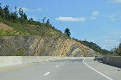 A road cut along U.S. Route 322 with visible anticline rock strata | |
 Map of Juniata County, Pennsylvania highlighting Fermanagh Township | |
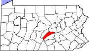 Map of Juniata County, Pennsylvania | |
| Country | United States |
| State | Pennsylvania |
| County | Juniata |
| Settled | 1754 |
| Incorporated | 1755 |
| Area[1] | |
| • Total | 32.49 sq mi (84.15 km2) |
| • Land | 32.05 sq mi (83.00 km2) |
| • Water | 0.44 sq mi (1.15 km2) |
| Population (2010) | |
| • Total | 2,811 |
| • Estimate (2016)[2] | 2,852 |
| • Density | 89.00/sq mi (34.36/km2) |
| Time zone | UTC-5 (EST) |
| • Summer (DST) | UTC-4 (EDT) |
| Area code(s) | 717 |
| FIPS code | 42-067-25648 |
Fermanagh Township is a township in Juniata County, Pennsylvania, United States. The population was 2,544 at the 2000 census.
It was named after County Fermanagh in Ireland.[3]
Geography
According to the United States Census Bureau, the township has a total area of 32.5 square miles (84 km2), of which, 32.1 square miles (83 km2) of it is land and 0.4 square miles (1.0 km2) of it (1.17%) is water.
Fermanagh Township is bordered by Mifflin County to the north, Fayette Township to the east and Walker Township to the south. The Juniata River forms the western and southern borders with Milford Township. The borough of Mifflintown lies along the river in the southwestern corner of the township.
Demographics
| Historical population | |||
|---|---|---|---|
| Census | Pop. | %± | |
| 2010 | 2,811 | — | |
| Est. 2016 | 2,852 | [2] | 1.5% |
| U.S. Decennial Census[4] | |||
As of the census[5] of 2000, there were 2,544 people, 971 households, and 728 families residing in the township. The population density was 79.2 people per square mile (30.6/km²). There were 1,098 housing units at an average density of 34.2/sq mi (13.2/km²). The racial makeup of the township was 98.86% White, 0.31% African American, 0.63% Asian, and 0.20% from two or more races. Hispanic or Latino of any race were 0.55% of the population.
There were 971 households, out of which 30.4% had children under the age of 18 living with them, 65.6% were married couples living together, 6.0% had a female householder with no husband present, and 25.0% were non-families. 21.8% of all households were made up of individuals, and 11.8% had someone living alone who was 65 years of age or older. The average household size was 2.44 and the average family size was 2.84.
In the township the population was spread out, with 21.9% under the age of 18, 5.5% from 18 to 24, 25.0% from 25 to 44, 25.6% from 45 to 64, and 22.1% who were 65 years of age or older. The median age was 44 years. For every 100 females, there were 88.9 males. For every 100 females age 18 and over, there were 84.7 males.
The median income for a household in the township was $34,643, and the median income for a family was $42,232. Males had a median income of $32,176 versus $20,417 for females. The per capita income for the township was $17,315. About 7.4% of families and 8.9% of the population were below the poverty line, including 11.0% of those under age 18 and 6.0% of those age 65 or over.
References
- ↑ "2016 U.S. Gazetteer Files". United States Census Bureau. Retrieved Aug 14, 2017.
- 1 2 "Population and Housing Unit Estimates". Retrieved June 9, 2017.
- ↑ Gannett, Henry (1905). The Origin of Certain Place Names in the United States. Govt. Print. Off. p. 125.
- ↑ "Census of Population and Housing". Census.gov. Retrieved June 4, 2016.
- ↑ "American FactFinder". United States Census Bureau. Archived from the original on 2013-09-11. Retrieved 2008-01-31.
Municipalities and communities of Juniata County, Pennsylvania, United States | ||
|---|---|---|
| Boroughs | | |
| Townships | ||
| CDPs | ||
| Unincorporated communities | ||
| Footnotes | ‡This populated place also has portions in an adjacent county or counties. | |
Coordinates: 40°37′00″N 77°24′59″W / 40.61667°N 77.41639°W