U.S. Route 6 in Pennsylvania
| |||||||
|---|---|---|---|---|---|---|---|
| GAR Highway; Roosevelt Highway | |||||||
 | |||||||
| Route information | |||||||
| Maintained by PennDOT | |||||||
| Length | 403 mi[1] (649 km) | ||||||
| Existed | 1926 (1924 as PA 7)–present | ||||||
| Tourist routes |
Crawford Lakelands Scenic Byway Gateway to the Endless Mountains Scenic Byway Governor Casey Scenic Byway | ||||||
| Major junctions | |||||||
| West end |
| ||||||
|
| |||||||
| East end |
| ||||||
| Location | |||||||
| Counties | Crawford, Erie, Warren, McKean, Potter, Tioga, Bradford, Wyoming, Lackawanna, Wayne, Pike | ||||||
| Highway system | |||||||
| |||||||

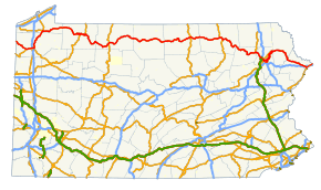
U.S. Route 6 travels east–west near the north edge of the U.S. state of Pennsylvania from the Ohio state line near Pymatuning Reservoir east to the Mid-Delaware Bridge over the Delaware River into Port Jervis, New York. It is the longest highway segment in the Commonwealth. Most of it is a two-lane rural highway, with some freeway bypasses around larger towns. Except east of Dunmore, where it is paralleled by Interstate 84, it is the main route in its corridor. What is now Interstate 80—the Keystone Shortway—was once planned along the US 6 corridor as a western extension of I-84.[2] The corridor was originally the Roosevelt Highway from Erie, Pennsylvania to Port Jervis, New York, designated Pennsylvania Route 7 in 1924.[3] The PA 7 designation soon disappeared, but as US 6 was extended and relocated, the Roosevelt Highway followed it. The Pennsylvania section of US 6 was renamed the Grand Army of the Republic Highway in 1946; this name was applied to its full transcontinental length by 1953.[4]
US 6 meets with U.S. Route 19 near Meadville, where it turns north with US 19 to a point east of Edinboro. There it turns east (while U.S. Route 6N heads west to U.S. Route 20 at West Springfield) and passes through the Northern Tier of Pennsylvania. At Towanda it turns more southeasterly to reach Dunmore, then turning back northeast out of Dunmore to Carbondale and generally east and southeast to New York. US 6 fully encompasses two Pennsylvania Scenic Byways: the Gateway to the Endless Mountains Scenic Byway along the bypass of Tunkhannock and the Governor Casey Scenic Byway along the freeway portion in Lackawanna County between I-81 in Dunmore and PA 247 in Jessup.[5][6]
Route description
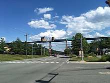
Ohio to Warren
.jpg)
US 6 enters Pennsylvania from Ohio in Crawford County, heading southeast as a two-lane undivided road through farmland and woodland to the north of Pymatuning State Park, which is home to the Pymatuning Reservoir. The route heads into Linesville, where it heads southeast through developed areas of the borough on Penn Street before turning east onto East Erie Street. The road continues southeast through more rural areas as it heads away from the state park. US 6 intersects the southern terminus of PA 618 before it reaches a junction with PA 285 on the western edge of the borough of Conneaut Lake. Here, US 6 heads east for a concurrency with PA 285 and the two routes head east through the borough on Water Street. The road intersects US 322/PA 18 in the center of Conneaut Lake, where the two routes join US 6 and PA 285. A block later, PA 285 splits to the south. US 6/US 322/PA 18 become a five-lane road with a center left-turn lane and head east out of the borough, passing to the south of Conneaut Lake. PA 18 splits from US 6/US 322 by turning to the north, with US 6/US 322 continuing east-northeast on Conneaut Lake Road through farms and woods with some development. The road heads into a business area to the west of Meadville and comes to an intersection with US 19 and the southern terminus of PA 98, at which point US 19 becomes concurrent with US 6 and US 322. The roadway becomes a four-lane divided highway and comes to a cloverleaf interchange with I-79. Past this interchange, the three routes reach an intersection with the southern terminus of PA 102 before curving north and entering Meadville upon crossing French Creek. The road becomes French Creek Parkway and US 322 splits to the east, with US 6/US 19 continuing north through developed areas. The two routes leave Meadville and narrow to a two-lane undivided road, passing through wooded areas with some fields and development as it follows the French Creek. In Saegertown, US 6/US 19 head north along Main Street and form a concurrency with PA 198. The road continues northeast through more rural areas alongside the creek, reaching the borough of Venango. Here, the two routes head north on Church Street before turning east onto Cussewago Street and curving north onto River Street. US 6/US 19 run northeast through farms and woods with some development to Cambridge Springs. The two routes head northeast on Venango Avenue before intersecting the northern terminus of PA 86 and the western terminus of PA 408 in the center of town, where they turn onto North Main Street and continue northeast. US 6/US 19 reach a junction with the southern terminus of PA 99 before leaving Cambridge Springs and heading through rural areas.[1][7]
US 6/US 19 continue into Erie County and comes to an intersection with the eastern terminus of US 6N, at which point US 6 splits from US 19 by turning to the east and crossing French Creek. The route passes through Mill Village and runs through a mix of farmland and woodland with some development. The road continues through rural land and turns northeast to reach Union City, where it comes to a junction with PA 8. At this point, US 6 heads north along with PA 8 through developed areas of the borough on South Main Street. In the downtown area of Union City, US 6 splits from PA 8 by turning east onto East High Street. The route leaves Union City and heads through farm fields and woods, reaching a junction with PA 89 to the north of Elgin. Here, PA 89 forms a concurrency with US 6 before splitting to the south. The route runs east-northeast through wooded areas with some development prior to entering the city of Corry. In Corry, US 6 becomes West Columbus Avenue and runs through developed areas in the northern part of the city, crossing PA 426 and becoming East Columbus Avenue. In the eastern part of Corry, the road passes south of Corry Memorial Hospital.[1][7]
The route enters Warren County and runs through farmland prior to an intersection with the western terminus of PA 957 in Columbus. The road heads through a mix of farms and woods before it curves to the southeast and comes to a junction with the southern terminus of PA 958. US 6 continues south-southeast through rural land and reaches the community of Pittsfield, where it intersects PA 27 and turns to the east, forming a concurrency with that route. The road heads east through a mix of rural areas and development to Youngsville, where PA 27 splits to the north. At this point, US 6 becomes a four-lane divided highway called the Youngsville Bypass that crosses Brokenstraw Creek and heads to the south of Youngsville. East of the borough, the route comes to an interchange with East Main Street that provides access to Youngsville and Irvine. The highway heads east through rural areas alongside the Brokenstraw Creek and reaches a trumpet interchange with US 62. At this point, US 62 heads east for a concurrency with US 6, and the road runs through wooded areas and development to the north of the Allegheny River, transitioning into a five-lane road with a center left-turn lane. The road becomes a four-lane divided highway again and reaches Warren, where US 62 and US 6 Bus. head northeast into the central part of the city at an interchange. US 6 crosses the Allegheny River and passes through developed areas in the southern part of Warren, reaching an eastbound exit and westbound entrance at Main Avenue. Past this interchange, the divided highway narrows to two lanes before the road curves to the southeast and becomes a two-lane undivided road that runs through wooded areas with the river to the northeast. At the southeast edge of Warren, US 6 Bus. returns to US 6 at an intersection.[1][7]
Warren to Mansfield
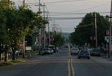
After passing Warren, US 6 reaches an intersection with the western terminus of PA 59, which heads east to follow the Allegheny River. From here, the route continues southeast into the Allegheny National Forest, winding to the south as it enters mountainous terrain. US 6 passes southeast through developed areas of Clarendon along North Main Street and South Main Street. Past here, the road heads south-southeast through more of the national forest, with occasional development along the road. In the community of Sheffield, the route comes to an intersection with the eastern terminus of PA 666 and curves to the east. US 6 continues through rugged forests and heads northeast before making a turn to the southeast.[1][7]
.jpg)
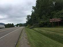
The route crosses into McKean County and heads southeast through more of the Allegheny National Forest. US 6 leaves the national forest and runs through more rural land with some development before it enters Kane. Here, the route heads south through developed areas on North Fraley Street, passing Kane Community Hospital before through the downtown area. Here, US 6 comes to a junction with the northern terminus of PA 66, with PA 66 continuing south on South Fraley Street and US 6 turning east onto Greeves Street. The route soon turns south onto Edgar James Street and east onto Biddle Street, passing more development and forming a short concurrency with PA 321. The road leaves Kane and becomes Kane Lantz Corners Road, winding east through a mix of farms and woods with some development. US 6 curves northeast and runs through more rural areas, coming to an intersection with US 219 in Lantz Corners. Past here, the route heads to the east and enters Mount Jewett, heading through developed areas of the borough as West Main Street and East Main Street. East of Mount Jewett, the road heads southeast through forested mountains, passing through Hazle Hurst and turning to the northeast. US 6 reaches a junction with the western terminus of PA 146 in Marvindale and continues northeast through wooded mountains with some fields and development. The road enters Smethport and becomes Marvin Street, heading north through developed areas and coming to an intersection with the eastern terminus of PA 59. Here, the route turns east onto West Main Street and passes through the downtown area, becoming East Main Street before turning east onto East Street and intersecting PA 46 on the eastern edge of the borough. At this point, PA 46 heads east for a concurrency with US 6, with the two route continuing to East Smethport, where PA 46 splits to the south. US 6 winds east through wooded areas with some farm fields. The road turns southeast and runs through forests before heading east into Port Allegany, where it crosses the Allegheny River and comes to a junction with PA 155. At this point, US 6 turns south for a concurrency with PA 155 and the two routes pass through developed areas of the borough along North Main Street and South Main Street. The two routes split at the south end of Port Allegany, with US 6 heading east through wooded mountains with some farm fields and development to the north of the Allegheny River.[1][7]
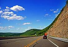
US 6 enters Potter County and continues east through a mix of forested mountains and farmland with some development north of the river, passing the community of Roulette. The road continues southeast through rural areas, turning to the northeast as it passes south of a tract of Susquehannock State Forest. The route enters more developed areas and continues into Coudersport, where it becomes Port Allegany Road and then Eulalia Street. US 6 turns east onto Chestnut Street and crosses the Allegheny River. The route turns north onto South Main Street and heads through the downtown area of Coudersport, crossing the river again and becoming North Main Street. US 6 reaches an intersection with PA 44, which continues north on North Main Street, near the Potter County Courthouse. At this point, US 6 and PA 44 turn east for a concurrency on East 2nd Street, crossing the Allegheny River and passing through more developed areas to the south of forests. The road has an intersection with the northern terminus of PA 872 before it leaves Coudersport as it passes south of Cole Memorial Hospital, heading southeast through wooded areas with some fields and development to the north of Mill Creek. In the community of Sweden Valley, PA 44 splits from US 6 by turning to the south to follow the creek. US 6 heads east through woodland, entering the Susquehannock State Forest and traversing Denton Hill. After descending the hill, the road passes north of Denton Hill State Park and south of the Pennsylvania Lumber Museum. The route comes to an intersection with the southern terminus of PA 449 in Walton, at which point it leaves the state forest. US 6 begins to follow the Pine Creek and it continues southeast through forested mountains with some fields and development. The route heads into Galeton and becomes West Main Street, heading east near developed areas and coming to a junction with the northern terminus of PA 144 in the center of the borough. Here, the road becomes East Main Street before it leaves the borough and runs through rural land with some development.[1][7]
.jpg)
US 6 crosses into Tioga County and continues east through forested mountains with some farm fields and development to the north of Pine Creek. In the community of Gaines, the route comes to an intersection with the southern terminus of PA 349. Following this, the road winds east through the Tioga State Forest and passes through more rugged terrain. Farther east, US 6 passes near some farm fields before it reaches an intersection with the western terminus of PA 362, where the Pine Creek turns to the south and runs through the Pine Creek Gorge. The road continues northeast through wooded mountains and farmland as it passes to the south of the Tioga State Forest. The route winds northeast through more rural land before it reaches an intersection with PA 287 in Wellsboro Junction. Here, US 6 turns south for a concurrency with PA 287, with the two routes running through a mix of farms and woods. The two routes head into Wellsboro and become Main Street, running through developed areas and turning to the southwest. The road comes to a junction with PA 660 in the downtown area, where PA 287 continues southwest along with PA 660 on Main Street while US 6 heads east along with PA 660 on East Avenue, which alternates from a three-lane road with a center left-turn lane to a two-lane road as it passes through more of the borough. The two routes leave Wellsboro and become a two-lane road called Roosevelt Highway that heads northeast through a mix of farmland and woodland with some development. PA 660 splits to the east and US 6 runs northeast through more rural land prior to reaching an interchange with the US 15 freeway on the western edge of Mansfield.[1][7]
Mansfield to Scranton
Past the US 15 interchange, US 6 heads into Mansfield and becomes West Wellsboro Street, heading through developed areas and crossing the Tioga River. The route continues into the downtown area, where it crosses US 15 Bus. and becomes West Wellsboro Street. US 6 becomes Sullivan Street and curves northeast and then southeast as it heads north of the Mansfield University of Pennsylvania campus. The route leaves Mansfield and becomes Roosevelt Highway, continuing southeast through wooded areas with some fields and reaching a junction with the southern terminus of PA 549. The road heads east through a mix of farmland and woodland with occasional development, passing through the community of Mainesburg.[1][7]
US 6 enters Bradford County and heads into the Endless Mountains region, continuing through hilly areas of farms and woods. The route passes through the borough of Sylvania on Sylvania Road before running through more rural land as Roosevelt Highway. The road turns southeast and passes to the southwest of Guthrie Troy Community Hospital before it enters Troy. Here, US 6 becomes West Main Street and runs through developed areas, curving to the east and intersecting PA 14 in the downtown area. At this point, PA 14 becomes concurrent with US 6 and the two route head northeast along Elmira Street. The road leaves Troy and turns east, with PA 14 splitting to the north. US 6 continues southeast along Roosevelt Highway through a mix of farm fields and woodland with occasional development, curving back to the east. The route continues through rural land and bends to the northeast, passing through Burlington on Main Street. The road becomes Roosevelt Highway again and winds east through more farms and woods, turning northeast. US 6 comes to an interchange with US 220, at which point it heads through developed areas in North Towanda. The route turns south-southeast and becomes Reuter Boulevard before it heads into Towanda, where it becomes York Avenue and runs past development. US 6 turns south onto Main Street and passes through the downtown area before turning east and crossing the Susquehanna River to leave Towanda. The route becomes Golden Mile Road, a three-lane road with a center left-turn lane that runs northeast through business areas in East Towanda. The road turns east and crosses PA 187 in Wysox, where it narrows to two lanes and becomes unnamed. US 6 continues southeast as follows a winding path that passes through a mix of farmland and woodland with some development to the northeast of the Susquehanna River. The route comes to an intersection with the southern terminus of PA 409 before it continues south alongside the river, traversing a hill before coming to Wyalusing. Here, US 6 runs southeast through developed areas of the borough on State Street and comes to a junction with the western terminus of PA 706. After leaving Wyalusing, the route heads northeast through farms and woods with some development, turning to the southeast as it passes north of the river.[1][7]
The route crosses into Wyoming County and heads into Laceyville, where it passes near developed areas and reaches an intersection with the southern terminus of PA 367. From here, the road continues southeast through farmland and woodland with occasional development alongside the Susquehanna River on Roosevelt Highway, winding along. US 6 bends to the east and reaches Meshoppen, where it becomes River Street and has a junction with the southern terminus of PA 267. The route continues southeast through rural areas with some industrial development as Roosevelt Highway and comes to an intersection with the northern terminus of PA 87, where it turns east as an unnamed road. The road heads through farm fields and woodland with some developed areas, curving to the south. US 6 comes to an interchange with the western terminus of US 6 Bus., which heads southeast into Tunkhannock. At this point, the route becomes a two-lane bypass of the center of Tunhannock to the south, closely following the Susquehanna River. The road curves east and enters Tunkhannock as it runs between developed areas to the north and the river to the south, coming to an intersection with PA 29 and crossing Tunkhannock Creek. US 6 continues east and intersects PA 92, which heads southeast along the Susquehanna River. At this point, PA 92 becomes concurrent with US 6 and the road soon reaches a junction with the eastern terminus of US 6 Bus. at the eastern edge of Tunkhannock. The two routes head northeast and follow Tunkhannock Creek through wooded areas with some farm fields and development. In Dixon, PA 92 splits to the northeast and US 6 continues east through more rural land with some development. Farther east, the route comes to an interchange with US 11, and the two routes become concurrent along a four-lane divided highway. The road heads east to Factoryville, where it intersects the western terminus of PA 107 and turns southeast through wooded areas and development. The highway turns to the east as it passes north of Keystone College.[1][7]
US 6/US 11 enter Lackawanna County and continue through forested areas with some development, turning to the southeast. In La Plume, the road has an intersection with the western end of PA 438. The two routes run through more rural land before heading south into Dalton. In this borough, the road becomes Lackawanna Trail and passes near developed areas, coming to an interchange with the western terminus of PA 632. Following this, US 6/US 11 run south-southeast through more forested areas and development, crossing into Clarks Summit. Here, the two routes turn to the southeast and narrow to two-lane undivided North State Street, passing through developed areas of the borough. In the center of Clarks Summit, the road becomes South State Street and gains a second eastbound lane. US 6/US 11 leave Clarks Summit and become Northern Boulevard, a five-lane road with a center left-turn lane that passes through a business district. The road passes under a viaduct carrying I-476 (Northeast Extension of the Pennsylvania Turnpike) before reaching a junction with the southern terminus of PA 407. A short distance later, US 6 splits from US 11 at a trumpet interchange onto a freeway that heads north, with US 11 continuing southeast along Northern Boulevard toward the city of Scranton. US 6 soon exits at another trumpet interchange, with the freeway becoming I-476 and making a hairpin turn to the southwest, and heads east a short distance to a trumpet interchange with I-81.[1][7]
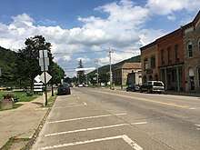
Scranton to Matamoras
.jpg)
At this interchange, US 6 heads south for a concurrency with I-81 on a four-lane freeway, turning southeast as it passes near developed areas with US 11 parallel to the southwest. The two roads pass through a gap between forested Bald Mountain to the southwest and forested Bell Mountain to the northeast, curving to the south. At this point, the freeway heads into the city of Scranton and the Wyoming Valley, continuing southeast to a cloverleaf interchange with the western terminus of US 6 Bus. and US 11 to the southwest of the Viewmont Mall near Dickson City. I-81/US 6 pass near more developed areas and reach the Main Avenue exit that serves Dickson City. Following this, the freeway crosses the Lackawanna River and turns to the south, entering Dunmore. I-81/US 6 curves southeast and passes near more development, reaching an interchange with PA 347. A short distance later, the freeway reaches an interchange where I-81 splits to the southwest, I-84/I-380 head to the southeast, and US 6 continues east along a four-lane freeway. Following this interchange, the route bends northeast and then northwest as it heads between a landfill to the west and the forested Moosic Mountains to the east, crossing into Throop. Here, the freeway has a partial cloverleaf interchange with Marshwood Road that serves Mount Cobb and Throop. US 6 curves north and then northeast as it runs between developed areas to the west and mountains to the east, heading into Olyphant and coming to the East Lackawanna Avenue exit which serves that borough. The route continues into Jessup and reaches an interchange with PA 247 that serves that borough. From here, the freeway continues through wooded area with some nearby commercial development, crossing into Archbald. Here, the route has a diamond interchange with Salem Road that serves Archbald and Cortez. The US 6 freeway curves north through forested land and enters Mayfield, reaching a diamond interchange with the eastern terminus of PA 107 that serves Jermyn and Mayfield. Past here, the route turns northeast and comes to a diamond interchange with Meredith Street that serves Carbondale and Childs. The freeway continues northeast through forests as it bypasses Carbondale to the east. US 6 makes a sharp turn east and the freeway ends as it comes to an intersection with the eastern terminus of US 6 Bus. Following this, US 6 becomes two-lane undivided Roosevelt Highway, heading east across the forested Moosic Mountains.[1][7]
While traversing the mountains, US 6 crosses into Wayne County. After crossing the Moosic Mountains, the route passes north of State Correctional Institution – Waymart before it heads into Waymart, passing through wooded development in the northern part of the borough as a three-lane road with a center left-turn lane and crossing PA 296. East of here, the road narrows to two lanes and passes through forests with some fields and development. In Prompton, US 6 intersects the southern terminus of PA 170 and crosses the Lackawaxen River. The route continues east through rural land with some development to the north of the Lackawaxen River, reaching Honesdale. Here, the road becomes West Park Street and passes through developed areas, heading south of Wayne Memorial Hospital and coming to an intersection with PA 191. At this point, US 6 turns south for a concurrency with PA 191, following the one-way pair of Main Street eastbound and Church Street westbound across the river and through the downtown area. PA 191 splits south and US 6 follows 4th Street east across the Lackawaxen River, soon heading southeast along Willow Avenue and Grandview Avenue. The route leaves Honesdale and gains a center left-turn lane, heading east and passing near businesses as Texas Palmyra Highway. The road turns southeast and narrows to two lanes, coming to a junction with the western terminus of PA 652. US 6 winds south through forested areas with some development to the east of the Lackawaxen River.Farther south, the route reaches Hawley and becomes Hudson Street, heading southeast near development and coming to an intersection with PA 590. At this point, PA 590 turns south for a concurrency with US 6 and the two routes follow Main Avenue, crossing the river and passing through the downtown area. US 6/PA 590 turn east and become Bellemonte Avenue, heading southeast through wooded areas of development before turning southwest onto Welwood Avenue and leaving Hawley. The road passes near businesses and gains a center left-turn lane, with PA 590 splitting to the west.[1][7]
US 6 crosses the Wallenpaupack Creek into Pike County and heads through wooded areas of development to the east of Lake Wallenpaupack in the community of Wilsonville as Lake Wallenpaupack Road. The road narrows to two lanes and reaches a junction with the northern terminus of PA 507, at which point it turns east away from the lake. The route heads east-southeast through dense forests in the northern Pocono Mountains as an unnamed road, coming to an intersection with the northern terminus of PA 402. US 6 continues east through rural land, passing through a tract of the Delaware State Forest prior to coming to a junction with the northern end of PA 739. The road heads east and crosses PA 434 as it runs through more forested areas. US 6 winds east before it turns southeast, passing through more woods with some development. Farther southeast, the route comes to an interchange with I-84. The road winds southeast through more forests with occasional development prior to reaching Milford. Here, US 6 becomes West Harford Street and passes through developed areas of the borough, coming to an junction with US 209. Here, US 209 continues southeast along East Harford Street and US 6 and US 209 head northeast concurrent on Broad Street, passing through the center of Milford. The two routes leave Milford and become an unnamed three-lane road with a center left-turn lane, passing through developed areas with some woodland to the northwest of the Delaware River. Farther northeast, the road comes closely parallel with I-84 to the northwest as it passes near more businesses. US 6/US 209 come to an interchange with I-84 before heading into Matamoras. Here, the road becomes Pennsylvania Avenue and narrows to two lanes as it runs through developed areas of the borough. The road comes to the Mid-Delaware Bridge over the Delaware River, at which point US 6/US 209 leave Pennsylvania for New York and head into Port Jervis.[1][7]
History
As approved by the American Association of State Highway Officials (AASHO) on November 11, 1926, the west end of US 6 was at Kane, where U.S. Route 120 continued west to Erie. (US 6 ended concurrent with U.S. Route 219, which ran east to Mt. Jewett along US 6 before turning north to New York.) US 6 also used present Pennsylvania Route 706, U.S. Route 11 and Pennsylvania Route 106 between Wyalusing and Carbondale, while U.S. Route 106 took the southerly route via Scranton.[8][9]
By the end of 1927, US 6 had replaced US 120 in running west from Kane to Erie (making US 120 no longer connect to its "parent" U.S. Route 20), and had swapped places with US 106 via Scranton; this took it along the Jefferson Highway. It was defined by AASHO to serve the following places in Pennsylvania: Erie, Waterford, Corry, Warren, Kane, Farmers Valley, Coudersport, Wellsboro, Canoe Camp, Mansfield, Towanda, Wyalusing, Tunkhannock, Clarks Summit, Scranton, Carbondale, Honesdale, Milford, and Matamoras.[10] By 1930 its west end was at 26th Street (U.S. Route 20) and State Street (US 6 - now Pennsylvania Route 505) in Erie. (By then U.S. Route 19 ended a block to the west on Peach Street, where it still ends today.)[11]
This original routing deviates majorly from present US 6 in the following places, roughly using the following current routes:[9]
- Pennsylvania Route 505 and Pennsylvania Route 97, Erie to Union City
- Pennsylvania Route 46, Pennsylvania Route 446 and Pennsylvania Route 155, Smethport to Port Allegany
- Pennsylvania Route 660 and U.S. Route 15 Business west of Mansfield
- Pennsylvania Route 92 and Pennsylvania Route 307, Tunkhannock to Clarks Summit
In 1931,[4] US 6 was extended west to Greeley, Colorado. It left its old route - which then became U.S. Route 6N - at Waterford, and headed south on former Pennsylvania Route 5 and U.S. Route 19 and west on U.S. Route 322 and former Pennsylvania Route 77 into Ohio. This whole section from Waterford to Cleveland, Ohio was regarded as temporary, but the only change was a relocation by 1936 along Pennsylvania Route 79 from Union City west to US 19 south of Waterford. (Former US 6 from Mount Union to Waterford became Pennsylvania Route 97. At the same time, US 6N was moved to the rest of former PA 79 from US 19 west to U.S. Route 20 - its current route.)[12]
Since then, only minor realignments and bypasses have been made to the route of US 6.
Major intersections
| County | Location[13] | mi | km | Exit | Destinations | Notes |
|---|---|---|---|---|---|---|
| Crawford | Conneaut Township | 0.0 | 0.0 | Continues into Ohio | ||
| Sadsbury Township | 13.4 | 21.6 | Southern terminus of PA 618 | |||
| Conneaut Lake | 13.9 | 22.4 | Western end of concurrency with PA 285 | |||
| 14.3 | 23.0 | Western end of concurrencies with US 322 and PA 18 | ||||
| 14.4 | 23.2 | Eastern end of concurrency with PA 285 | ||||
| Sadsbury Township | 15.3 | 24.6 | Eastern end of concurrency with PA 18 | |||
| Vernon Township | 19.9 | 32.0 | Southern end of concurrency with US 19, southern terminus of PA 98 | |||
| 21.0 | 33.8 | I-79 exit 147 | ||||
| 21.8 | 35.1 | Southern terminus of PA 102 | ||||
| Meadville | 22.8 | 36.7 | Eastern end of concurrency with US 322 | |||
| Saegertown | 29.3 | 47.2 | Southern end of concurrency with PA 198 | |||
| 30.0 | 48.3 | Northern end of concurrency with PA 198 | ||||
| Cambridge Springs | 38.1 | 61.3 | Northern and Western termini of PA 86/408 respectively | |||
| 38.2 | 61.5 | Southern terminus of PA 99 | ||||
| Erie | LeBoeuf Township | 44.2 | 71.1 | Northern end of concurrency with US 19, eastern terminus of US 6N | ||
| Union City | 52.9 | 85.1 | Southern end of concurrency with PA 8 | |||
| 53.5 | 86.1 | Northern end of concurrency with PA 8 | ||||
| Elgin–Wayne Township line | 59.2 | 95.3 | Western end of concurrency with PA 89 | |||
| Wayne Township | 60.8 | 97.8 | Eastern end of concurrency with PA 89 | |||
| Corry | 64.8 | 104.3 | ||||
| Warren | Columbus Township | 67.6 | 108.8 | Western terminus of PA 957 | ||
| Pittsfield Township | 77.0 | 123.9 | Southern terminus of PA 958 | |||
| 82.6 | 132.9 | Western end of concurrency with PA 27 | ||||
| Youngsville | 85.3 | 137.3 | Eastern end of concurrency with PA 27 | |||
| Brokenstraw Township | Youngsville, Irvine | Interchange | ||||
| 89.1 | 143.4 | Western end of concurrency with US 62, interchange | ||||
| Warren | 94.0 | 151.3 | Western terminus of US 6 BUS, eastern end of concurrency with US 62, interchange | |||
| Main Avenue | Eastbound exit and westbound entrance | |||||
| Mead Township | 96.9 | 155.9 | Eastern terminus of US 6 BUS | |||
| 97.1 | 156.3 | Western terminus of PA 59 | ||||
| Sheffield Township | 107.1 | 172.4 | Eastern terminus of PA 666 | |||
| McKean | Kane | 122.6 | 197.3 | Northern terminus of PA 66 | ||
| 123.1 | 198.1 | Western end of concurrency with PA 321 | ||||
| 123.2 | 198.3 | Eastern end of concurrency with PA 321 | ||||
| Hamlin Township | 130.6 | 210.2 | ||||
| 140.3 | 225.8 | Western terminus of PA 146 | ||||
| Smethport | 147.9 | 238.0 | Eastern terminus of PA 59 | |||
| 148.9 | 239.6 | Western end of concurrency with PA 46 | ||||
| Keating Township | 149.6 | 240.8 | Eastern end of concurrency with PA 46 | |||
| Port Allegany | 157.3 | 253.1 | Northern end of concurrency with PA 155 | |||
| 158.5 | 255.1 | Southern end of concurrency with PA 155 | ||||
| Potter | Coudersport | 174.7 | 281.2 | Western end of concurrency with PA 44 | ||
| 176.7 | 284.4 | Northern terminus of PA 872 | ||||
| Sweden Township | 178.8 | 287.8 | Eastern end of concurrency with PA 44 | |||
| Ulysses Township | 189.3 | 304.6 | Southern terminus of PA 449 | |||
| Galeton | 196.9 | 316.9 | Northern terminus of PA 144 | |||
| Tioga | Gaines Township | 201.5 | 324.3 | Southern terminus of PA 349 | ||
| Shippen Township | 208.9 | 336.2 | Western terminus of PA 362 | |||
| Delmar Township | 216.9 | 349.1 | Western end of concurrency with PA 287 | |||
| Wellsboro | 219.5 | 353.3 | Eastern end of concurrency with PA 287, western end of concurrency with PA 660 | |||
| Charleston Township | 225.8 | 363.4 | Eastern end of concurrency with PA 660 | |||
| Mansfield | 231.5 | 372.6 | Interchange | |||
| 232.2 | 373.7 | |||||
| Richmond Township | 234.0 | 376.6 | Southern terminus of PA 549 | |||
| Bradford | Troy | 249.2 | 401.0 | Western end of concurrency with PA 14 | ||
| Troy Township | 249.9 | 402.2 | Eastern end of concurrency with PA 14 | |||
| North Towanda Township | 266.7 | 429.2 | Interchange | |||
| Wysox Township | 272.8 | 439.0 | ||||
| Wyalusing Township | 280.3 | 451.1 | Southern terminus of PA 409 | |||
| Wyalusing | 285.1 | 458.8 | Western terminus of PA 706 | |||
| Wyoming | Braintrim Township | 293.2 | 471.9 | Southern terminus of PA 367 | ||
| Meshoppen | 300.2 | 483.1 | Southern terminus of PA 267 | |||
| Washington Township | 303.6 | 488.6 | Northern terminus of PA 87 | |||
| Tunkhannock Township | 307.8 | 495.4 | Western terminus of US 6 Bus. | |||
| Tunkhannock | 309.6 | 498.3 | ||||
| Tunkhannock Township | 310.2 | 499.2 | Western end of concurrency with PA 92 | |||
| 310.4 | 499.5 | Eastern terminus of US 6 BUS | ||||
| 312.7 | 503.2 | Eastern end of concurrency with PA 92 | ||||
| Clinton Township | 318.7 | 512.9 | Northern end of concurrency with US 11 | |||
| Clinton Township–Factoryville line | 319.3 | 513.9 | Western terminus of PA 107 | |||
| Lackawanna | La Plume Township | 321.3 | 517.1 | Western terminus of PA 438 | ||
| Dalton | 323.1 | 520.0 | Western terminus of PA 632, interchange | |||
| South Abington Township | 328.0 | 527.9 | ||||
| Western terminus of freeway | ||||||
| 328.2 | 528.2 | Eastern end of concurrency with US 11 | ||||
| Northern terminus of I-476, I-476 / Penna Turnpike NE Extension exit 131 (Clarks Summit) | ||||||
| Western end of concurrency with I-81, I-81 exit 194 | ||||||
| Scranton | 191 | Western terminus of US 6 BUS | ||||
| 190 | Main Avenue – Dickson City | |||||
| Dunmore | 334.0 | 537.5 | 188 | |||
| 335.6 | 540.1 | Eastern end of concurrency with I-81, I-81 exit 187; Western terminus of I-84 and northern terminus of I-380, I-84/I-380 exit 1 | ||||
| Throop | 1 | Marshwood Road – Mount Cobb, Throop | ||||
| Olyphant | 2 | East Lackawanna Avenue – Olyphant | ||||
| Jessup | 340.2 | 547.5 | 3 | |||
| Archbald | 4 | Salem Road – Archbald, Cortez | ||||
| Archbald–Mayfield line | 345.6 | 556.2 | 5 | Eastern terminus of PA 107 | ||
| Carbondale Township | 6 | Meredith Street – Carbondale, Childs | ||||
| Eastern terminus of freeway | ||||||
| 350.6 | 564.2 | 7 | Eastern terminus of US 6 Bus. | |||
| Wayne | Waymart | 354.3 | 570.2 | |||
| Prompton | 358.5 | 576.9 | Southern terminus of PA 170 | |||
| Honesdale | 362.8 | 583.9 | Northern end of concurrency with PA 191 | |||
| 363.4 | 584.8 | Southern end of concurrency with PA 191 | ||||
| Texas Township | 366.2 | 589.3 | Western terminus of PA 652 | |||
| Hawley | 371.6 | 598.0 | Northern end of concurrency with PA 590 | |||
| Palmyra Township | 373.5 | 601.1 | Southern end of concurrency with PA 590 | |||
| Pike | Palmyra Township | 374.9 | 603.3 | Northern terminus of PA 507 | ||
| Blooming Grove Township | 377.4 | 607.4 | Northern terminus of PA 402 | |||
| Blooming Grove–Lackawaxen township line | 380.9 | 613.0 | Northern terminus of PA 739 | |||
| 384.7 | 619.1 | Western end of concurrency with PA 434 | ||||
| Dingman–Milford township line | 395.5 | 636.5 | Interchange, I-84 exit 46 | |||
| Milford | 397.7 | 640.0 | Western end of concurrency with US 209 | |||
| Westfall Township | 402.9 | 648.4 | Interchange, I-84 exit 53 | |||
| Delaware River | Mid-Delaware Bridge | |||||
| Continues into New York | ||||||
1.000 mi = 1.609 km; 1.000 km = 0.621 mi
| ||||||
See also

References
- 1 2 3 4 5 6 7 8 9 10 11 12 13 14 15 Google (July 12, 2017). "U.S. Route 6 in Pennsylvania" (Map). Google Maps. Google. Retrieved July 12, 2017.
- ↑ Official Route Numbering for the National System of Interstate and Defense Highways, August 14, 1957
- Note: the corridor had already been shifted south by September 1955, but the numbering was done on a map from August 2, 1947.
- ↑ "U.S. 22 - The William Penn Highway". Federal Highway Administration. Retrieved 6 October 2014.
- 1 2 Richard F. Weingroff. "U.S. 6 - The Grand Army of the Republic Highway". Retrieved October 6, 2014.
- ↑ "Gateway to the Endless Mountains". VisitPA.com. Retrieved March 27, 2012.
- ↑ "Governor Casey". VisitPA.com. Retrieved March 27, 2012.
- 1 2 3 4 5 6 7 8 9 10 11 12 13 14 Pennsylvania State Road Atlas (Map). ADC Map. 2003.
- ↑ Bureau of Public Roads & American Association of State Highway Officials (November 11, 1926). United States System of Highways Adopted for Uniform Marking by the American Association of State Highway Officials (Map). 1:7,000,000. Washington, DC: U.S. Geological Survey. OCLC 32889555. Retrieved November 7, 2013 – via University of North Texas Libraries.
- 1 2 1927 map of Pennsylvania
- ↑ United States Numbered Highways, 1927
- ↑ 1930 map of Pennsylvania, back side 5.75 MiB
- ↑ Ohio Transportation Maps Archived 2007-06-25 at the Wayback Machine.
- ↑ "Video Log". Pennsylvania Department of Transportation. Retrieved June 10, 2016.
External links
Route map:
| Wikimedia Commons has media related to U.S. Route 6 in Pennsylvania. |
| Previous state: Ohio |
Pennsylvania | Next state: New York |