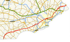
U.S. Route 1 in Pennsylvania
| ||||
|---|---|---|---|---|
 | ||||
| Route information | ||||
| Maintained by PennDOT and DRJTBC | ||||
| Length | 80.916 mi[1] (130.222 km) | |||
| Major junctions | ||||
| South end |
| |||
|
| ||||
| North end |
| |||
| Location | ||||
| Counties | Chester, Delaware, Montgomery, Philadelphia, Bucks | |||
| Highway system | ||||
| ||||

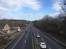
U.S. Route 1 (US 1) is a major north–south U.S. Highway, extending from the Florida Keys in the south to the Canadian border in the north. In the U.S. state of Pennsylvania, US 1 runs for 81 miles (130 km) from the Maryland state line near Oxford to the New Jersey state line near Trenton, through the southeastern portion of the state. The route runs southwest to northeast, and serves as a major arterial road for many of the suburbs in the Delaware Valley area. South of Philadelphia, the road mostly follows the alignment of the old Baltimore Pike. Within Philadelphia, it mostly follows Roosevelt Boulevard.
Route description
Chester County
US 1 enters Pennsylvania from Maryland in West Nottingham Township, Chester County, heading northeast as a two-lane undivided road that soon widens into a four-lane divided highway. The road curves north and runs through fields and woods with some development, becoming a four-lane freeway that is called the John H. Ware III Memorial Highway. The route runs through rural land with some nearby homes and commercial development, coming to an interchange with PA 272 west of the community of Nottingham. From here, US 1 curves to the northeast and continues into East Nottingham Township, passing through a mix of farmland and woodland with some residences. The freeway skirts into the western portion of the borough of Oxford and reaches a diamond interchange with PA 472 that serves the borough. The route runs through more rural areas with some nearby development and enters Lower Oxford Township, where it bends to the east-northeast and comes to an interchange with PA 10 that also provides access to Oxford. US 1 continues through farm fields and woods and crosses into Upper Oxford Township, where it comes to the PA 896 exit.[2][3]
The freeway crosses the East Branch Big Elk Creek into Penn Township and heads east to a diamond interchange at PA 796 north of the community of Jennersville. The route passes through a mix of fields, woods, and residential development ad it continues east into London Grove Township and comes to the PA 841 interchange north of the borough of West Grove. US 1 curves northeast and reaches a diamond interchange serving PA 41 northwest of the borough of Avondale. The freeway continues through rural land with some development and bends to the east, heading into New Garden Township and coming to an interchange at Newark Road north of the community of Toughkenamon. The route heads through wooded areas with some nearby residential development and skirts into the southern portion of East Marlborough Township, where it has an interchange with PA 82 north of the borough of Kennett Square. From here, US 1 continues east and enters Kennett Township, where it passes near more development and comes to the northern terminus of the freeway at a southbound exit and northbound entrance with Baltimore Pike.[2][3]
At this point, US 1 continues northeast along four-lane divided East Baltimore Pike into East Marlborough Township and passes businesses, widening to six lanes. The road narrows to four lanes and passes near homes and businesses before coming to an interchange that provides access to Longwood Gardens to the north of the road, at which point it crosses back into Kennett Township. A short distance later, US 1 comes to an intersection with PA 52, at which point that route heads onto East Baltimore Pike concurrent with US 1. The road heads into wooded areas with some homes and businesses, at which point PA 52 splits to the southeast towards Wilmington, Delaware. The route turns to the northeast and crosses into Pennsbury Township, where the official name becomes Baltimore Pike. The road curves to the east again and passes through more woodland with some residential and commercial development, crossing an East Penn Railroad line before heading across the Brandywine Creek.[2][3]
Delaware County
Upon crossing the Brandywine Creek, US 1 continues into Chadds Ford Township in Delaware County and passes to the north of the Brandywine River Museum. The route heads into the community of Chadds Ford and intersects Creek Road (which until 2003 was also PA 100) in a commercial area. The road continues through wooded areas with some development, passing to the south of the Brandywine Battlefield. The route curves northeast and heads into areas of businesses, intersecting US 202/US 322 in Painters Crossroads. Here, US 322 turns east to join US 1 in a concurrency along Baltimore Pike, running past more commercial establishments in Concord Township. In Concordville, US 322 splits to the southeast and US 1 continues along Baltimore Pike, heading into more wooded areas with occasional businesses.[2][4]

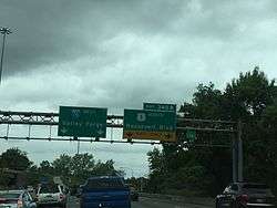
The route curves to the east and enters the borough of Chester Heights, passing businesses before heading into forested areas, where it passes the corporate headquarters of Wawa Inc. The road turns northeast and crosses the Chester Creek into Middletown Township, passing under SEPTA's Media/West Chester Branch. US 1 continues into commercial areas, coming to an intersection with PA 452 in the community of Lima. Following this, the route continues east and passes between the closed Granite Run Mall to the north and Riddle Memorial Hospital to the south, coming to an interchange with PA 352. A short distance later, US 1 splits from Baltimore Pike by heading northeast onto the Media Bypass, a four-lane freeway which bypasses the borough of Media to the north. US 1 runs through wooded areas with some nearby homes and crosses Ridley Creek into Upper Providence Township. The freeway continues northeast before it curves to the east and comes to a diamond interchange at PA 252 in the community of Rose Tree. The route runs through more wooded areas with some homes and comes to a southbound exit and northbound entrance at State Road. Following this, US 1 crosses the Crum Creek into Marple Township and comes to a three-level diamond interchange at I-476.[2][4]
Past the I-476 interchange, US 1 continues east and heads into business areas, where the freeway ends and the route becomes four-lane divided South State Road, passing south of a shopping center. The route crosses into Springfield Township and reaches a diamond interchange with PA 320, with the southbound exit providing access to the shopping center. The road continues into residential areas and becomes North State Road upon crossing Springfield Road. US 1 curves northeast and crosses the Darby Creek into Upper Darby Township, where it heads into business areas. State Road splits to the northeast and the route becomes Township Line Road, which heads north into Drexel Hill as a four-lane undivided road through residential neighborhoods. The road passes commercial development and curves to the northeast, becoming the border between Haverford Township to the northwest and Upper Darby Township to the southeast. US 1 continues past homes as it heads through Drexel Hill, passing to the southeast of a golf course. The route heads into the community of Llanerch, where it gains a center left-turn lane and passes between a shopping center to the northwest and residences to the southeast. The road crosses Darby Road before it reaches an intersection with PA 3 a short distance later. From here, US 1 becomes a four-lane undivided road and continues northeast past residences and a few businesses before passing northwest of a golf course. The route passes over SEPTA's Norristown High Speed Line south of the Township Line Road station before it comes to a bridge over Cobbs Creek.[2][4] Upon crossing Cobbs Creek, US 1 runs along the border between Haverford Township in Delaware County to the northwest and the city of Philadelphia to the southeast, passing between homes to the northwest and a golf course to the southeast.[2][4][5]
City Avenue
The route becomes known as City Avenue (colloquially City Line Avenue) and forms the border between Lower Merion Township in Montgomery County to the northwest and the city of Philadelphia to the southeast, at which point it continues northeast as a five-lane road with a center left-turn lane past residential areas to the northwest and businesses to the southeast. The road crosses Haverford Road and continues through wooded residential areas, with the suburban community of Penn Wynne to the northwest and the Philadelphia neighborhood of Overbrook to the southeast. US 1 passes to the southeast of Lankenau Medical Center before it reaches an intersection with US 30 (Lancaster Avenue). Past this intersection, the route runs between the St. Charles Borromeo Seminary to the northwest and residential development to the southeast before it passes over Amtrak's Philadelphia to Harrisburg Main Line north of the Overbrook station, which serves SEPTA's Paoli/Thorndale Line. The road passes mixed residential development before heading through the campus of Saint Joseph's University. US 1 becomes lined with businesses as it passes between the Lower Merion Township community of Bala Cynwyd to the northwest and the Philadelphia neighborhood of Wynnefield to the southeast. The route comes to a bridge over SEPTA's Cynwyd Line south of the Bala station before it reaches an intersection with the eastern terminus of PA 23 and Conshohocken Avenue. The road passes more commercial development and crosses Belmont Avenue, where it passes north of the Belmont Reservoir. US 1 becomes a four-lane divided highway and heads past businesses and office buildings, passing between the WCAU-TV studios to the northwest and the WPVI-TV studios to the southeast at the Monument Road intersection.[2][5][6]
Roosevelt Boulevard
US 1 comes to an interchange with I-76 (Schuylkill Expressway), at which point City Avenue heads across the Schuylkill River and becomes Lincoln Drive and US 1 heads southeast concurrent with I-76 on the Schuylkill Expressway, an eight-lane freeway that fully enters Philadelphia and runs between a yard on Norfolk Southern's Harrisburg Line and the river to the north and wooded areas of Fairmount Park to the south. US 1 splits from I-76 by heading northeast on the Roosevelt Expressway, a six-lane freeway. Immediately after the split, the route heads onto the Twin Bridges, which carry the route over Norfolk Southern's Harrisburg Line, a wye connection between the Harrisburg Line and CSX's Trenton Subdivision that uses the Philadelphia and Reading Railroad, Schuylkill River Viaduct, Martin Luther King, Jr. Drive, the Schuylkill River Trail, the Schuylkill River, Kelly Drive, and Ridge Avenue. From here, the freeway heads into the East Falls neighborhood and passes near urban residential and commercial development, coming to a southbound exit and northbound entrance serving Ridge Avenue and Kelly Drive. US 1 passes under SEPTA's Manayunk/Norristown Line and continues through developed areas, passing to the southeast of Queen Lane Reservoir. The route comes to a southbound exit and entrance that serves Fox Avenue and Henry Avenue. The freeway passes over SEPTA's Chestnut Hill West Line as it comes to an interchange with Wissahickon Avenue, which also provides access to Germantown Avenue and Hunting Park Avenue, in the Nicetown–Tioga neighborhood. Here, the freeway narrows to two northbound lanes while retaining three southbound lanes. US 1 heads into North Philadelphia and crosses through Fernhill Park before it curves east and comes to a bridge over SEPTA's Main Line and CSX's Trenton Subdivision north of SEPTA's Roberts Yard and south of the Wayne Junction station. The route continues along the bridge over urban neighborhoods before it descends into a cut as a four-lane freeway, with a northbound exit and southbound entrance serving PA 611 (Broad Street), provided via frontage roads. Past this interchange, US 1 comes to a southbound exit and northbound entrance with US 13 north of the Hunting Park neighborhood, where the Roosevelt Expressway ends.[2][5]
At this point, US 1 becomes concurrent with US 13 on Roosevelt Boulevard, a wide boulevard with local-express lanes that has 12 lanes total in a 3-3-3-3 configuration. Along the Roosevelt Boulevard, access between the inner and outer carriageways is provided with narrow crossover ramps immediately between them; for most intersections, left turns are only permitted from the inner pair (or from separate left turn roadways) and right turns only from the outer, and crossing between them is not permitted at the intersections. Many intersections also have red light cameras. The boulevard continues past urban residential neighborhoods, coming to the 5th Street junction, where the local lanes intersect at-grade and the express lanes pass over the street on a bridge. US 1/US 13 continues east and passes through the Feltonville neighborhood, where it intersects Rising Sun Avenue, before it crosses the Tacony Creek. At this point, Roosevelt Boulevard continues into Northeast Philadelphia and curves to the southeast, passing between a shopping center to the northeast and Friends Hospital to the southwest. The boulevard curves to the northeast again and passes near rowhomes before reaching the Oxford Circle. At this point, the local lanes pass through the Oxford Circle, a traffic circle at Cheltenham Avenue, Castor Avenue, and the southern terminus of PA 232, which runs along Oxford Avenue. The express lanes pass under the Oxford Circle. Past the circle, Roosevelt Boulevard continues east-northeast through residential areas.[2][5]
The road crosses Bustleton Avenue and US 13 splits from US 1 by heading southeast on the one-way pair of Robbins Street northbound and Levick Street southbound, while US 1 continues northeast along Roosevelt Boulevard past urban homes and businesses. The boulevard bends to the northeast after crossing Harbison Avenue and continues through developed areas in the Mayfair neighborhood. The route comes to an interchange with PA 73 (Cottman Avenue), where the local lanes intersect PA 73 while the express lanes pass under it. Ramps provide access from the express lanes to the local lanes prior to the PA 73 junction in each direction. Past here, US 1 passes to the southeast of the Roosevelt Mall before it curves north and runs near more residential and commercial development. The boulevard turns to the northeast and heads east of the Rhawnhurst neighborhood, crossing Rhawn Street before reaching an interchange with Solly Avenue/Holme Avenue at the former Pennypack Circle, where the local lanes intersect Solly Avenue/Holme Avenue while the express lanes head under the street. Following the interchange, the route runs to the west of Nazareth Hospital before it heads into wooded areas of Pennypack Park, where it passes over the Pennypack Creek and the parallel Pennypack Trail.[2][5]
After passing through the park, US 1 heads through residential areas before running past businesses and coming to an intersection with the southern terminus of PA 532 at Welsh Road. The boulevard becomes lined with more commercial development and crosses Grant Avenue. The route runs between a residential neighborhood to the northwest and a shopping center to the southeast before it passes northwest of Northeast Philadelphia Airport and heads past more commercial establishments, coming to an intersection with PA 63 at Red Lion Road. At this point, PA 63 becomes concurrent with US 1 on Roosevelt Boulevard, and the boulevard heads northeast through areas of businesses and industrial parks. After intersecting Byberry Road, the concurrency with PA 63 ends at a cloverleaf interchange, where PA 63 heads southeast onto the Woodhaven Road freeway, which is lined with frontage roads. US 1 continues northeast past industrial parks, crossing Southampton Road, before it passes to the west of Benjamin Rush State Park. At this point, the local and express lanes merge, and the route becomes a divided highway with three northbound lanes and four southbound lanes that passes over the Poquessing Creek.[2][5]
Bucks County
Upon crossing the Poquessing Creek, US 1 leaves Philadelphia and enters Bensalem Township in Bucks County. At this point, the road becomes Lincoln Highway, heading past businesses and narrowing to six total lanes at the Old Lincoln Highway intersection. The route becomes a freeway and comes to a partial cloverleaf interchange with PA 132, with all movements complete except a ramp from eastbound PA 132 to southbound US 1, at which point it narrows to four lanes. A short distance past PA 132, the freeway comes to the Bensalem interchange with the Pennsylvania Turnpike (I-276). From here, US 1 becomes the Martin Luther King Jr. Memorial Highway and passes near several businesses before coming to an interchange with Rockhill Drive, which provides access to the Neshaminy Mall to the east of the road. The route passes between an office park to the west and the mall to the east before it heads into wooded areas and crosses the Neshaminy Creek. Upon crossing the creek, the freeway heads into Middletown Township and comes to a northbound exit and southbound entrance with the southern terminus of US 1 Bus. From here, US 1 passes over CSX's Trenton Subdivision and SEPTA's West Trenton Line before it becomes paralleled with frontage roads on each side, heading near homes and businesses. The route curves to the east-northeast and runs through residential areas, crossing into the borough of Langhorne Manor, where it has a northbound exit and southbound entrance at Hulmeville Avenue. The freeway heads back into Middletown Township again and comes to an interchange with PA 413. Past this interchange, the frontage roads end and US 1 heads northeast through wooded areas with nearby development, reaching the PA 213 exit. The route passes near residential and commercial development before it heads through wooded areas and bends to the east-northeast. The freeway passes over the West Trenton Line and Trenton Subdivision south of the Woodbourne station on the West Trenton Line before it comes to a bridge over Norfolk Southern's Morrisville Line and reaches a cloverleaf interchange with I-295.[2][7]
Past the I-295 interchange, US 1 heads east and runs to the north of an industrial park. The route becomes the border between Lower Makefield Township to the north and Falls Township to the south and comes to a diamond interchange with Oxford Valley Road, which heads south to provide access to the Oxford Valley Mall and the Sesame Place amusement park. From here, the freeway fully enters Falls Township and runs between woodland to the north and industrial areas to the south, continuing to an interchange with Stony Hill Road and the northern terminus of US 1 Bus. north of the community of Fairless Hills. A short distance later, US 1 comes to a modified cloverleaf interchange with the northern terminus of the US 13 freeway and Pine Grove Road, where the ramp from southbound US 1 to US 1 Bus. splits from the freeway and also acts as a collector/distributor road for the US 13 interchange. Following this interchange, the route reaches a northbound exit and southbound entrance with the southern terminus of PA 32. The ramp from southbound PA 32 merges into the collector/distributor road for the US 13 and US 1 Bus. interchanges. At this point, the freeway curves to the northeast and runs through wooded areas with nearby residential and commercial development, entering the borough of Morrisville. Here, the route comes to a bridge over the Delaware Canal and a Conrail Shared Assets Operations railroad line before it comes to an interchange with Pennsylvania Avenue that provides access to Morrisville. Past this interchange, US 1 comes to a southbound toll plaza before it passes over the Delaware River on the Trenton-Morrisville Toll Bridge, where it leaves Pennsylvania for New Jersey and heads into the city of Trenton.[2][7]
History
In Chester County, before the US 1 expressway was built there, US 1 continued up Baltimore Pike (which now has a dead-end section in Nottingham where northbound US 1 veers away from the Baltimore Pike alignment onto the expressway). In Oxford, US 1 northbound ran on S. 3rd Street, then turned right on Market Street (PA 472) (N. 3rd Street is the beginning of PA 10), then very quickly turned left onto Lincoln Street, and after leaving Oxford the road ran by Lincoln University. Approaching Avondale, Baltimore Pike traffic bent southeast along Pennsylvania Avenue (PA 41), then Baltimore Pike split off after Avondale. In the town of Kennett Square, northbound US 1 ran along Cypress Street (southbound US 1 ran along State Street), and those streets were marked E-W, not N-S. After Kennett Square, the US 1 expressway ends and its traffic merges onto Baltimore Pike.
Except for the southernmost part of Baltimore Pike at Nottingham, the Chester County part of old US 1 is still driveable. There is the dead end mentioned above; also, a small part of Baltimore Pike is permanently blocked by the Herr's Snacks company property.
Between Philadelphia and Trenton, US 1 is a part of the Lincoln Highway, a cross-country road that ran from New York City to San Francisco, California. It was also a part of the Byberry and Bensalem Turnpike between Oakford (Neshaminy Creek) and Philadelphia.
From the Lancaster Turnpike, where the Lincoln Highway headed west along U.S. Route 30, the Lincoln Highway originally headed east along Market Street to Penn Square, where it turned north onto Broad Street (Prior to the building of Roosevelt Boulevard, the main road followed Frankford Avenue to Bustleton Avenue from downtown.)
A bypass was added around downtown Philadelphia (in addition to the downtown route) in 1924, using Hunting Park Avenue, Ridge Avenue and City Avenue.[8][9] This alignment is now used by U.S. 1, except that Hunting Park and Ridge Avenues are now bypassed by the Roosevelt Expressway and Schuylkill Expressway.
From Broad Street, the Lincoln Highway then headed north on the Roosevelt Boulevard. By 1914, the Roosevelt Boulevard was completed to Rhawn Street, and the Lincoln Highway turned off the Boulevard there to reach Bustleton Avenue. The old alignment splits from Bustleton Avenue at Haldeman Avenue and then follows Roosevelt Boulevard. (A short piece of Old Bustleton Avenue southwest of Welsh Road was used, crossing Pennypack Creek east of the current bridge.[9])
A 1920 extension took the Boulevard to Welsh Road, allowing traffic to turn off Bustleton Avenue there (that route is still Route 532), and a 1920s extension took it to the intersection with Old Lincoln Highway just north of the Poquessing Creek bridge. North of there the present US 1 was completed in 1933 to the south end of the 1923 Langhorne bypass and in 1938 to Bellevue Avenue (Route 413) in downtown Langhorne.[9]

From near Hornig Road in Northeast Philadelphia, the old alignment heads through woods, closed to traffic, paralleling power lines, after which it was upgraded on the spot to become Roosevelt Boulevard. The original route is then gated at an 1805 stone bridge across Poquessing Creek at the Philadelphia city line, just before crossing Roosevelt Boulevard. After crossing Street Road, the Old Lincoln Highway then becomes one-way southbound past the Bristol Road intersection and crosses the Neshaminy Creek. (This bridge itself was built in 1921 to replace a covered bridge just to the west.[9])
The present route of Lincoln Highway and US 1 Business was built in 1923,[9] bypassing Langhorne to the south and avoiding two railroad crossings. This crosses under the US 1 freeway just south of the railroad, where the older route had crossed the railroad. From Oakford, the Old Lincoln Highway heads northeast, no longer crossing SEPTA's West Trenton line, as the US 1 freeway crosses just to the east. It then headed onto Maple Avenue (Route 213) to pass through Langhorne. Past Langhorne, the original route used what is presently known as Lincoln Highway (U.S. Route 1 Business).
At Fallsington, the original road crossed the Pennsylvania Railroad's Trenton Cutoff on a bridge just east of the present bridge, built on a reverse curve to shorten the span. It used Trenton Road and Main Street from the bridge to the intersection with Woolston, where Main Street is now cut. In 1917, an underpass under the railroad was built to the west on Woolston Drive; this became the main route by 1924.[9][10]
It then headed toward Morrisville, where it first crossed the Delaware River the Calhoun Street Bridge, running along Trenton Avenue to Fallsington. In 1920 it was moved to the Bridge Street Bridge, passing through downtown Morrisville.
On November 21, 1988, an act of the Pennsylvania General Assembly designated the portion of US 1 in Bucks County between the Pennsylvania Turnpike and the New Jersey border as the Martin Luther King Jr. Expressway after civil rights leader Martin Luther King Jr.[11] On May 31, 2002, the US 1 freeway in Chester County between the Maryland border and Kennett Square was designated the John H. Ware III Memorial Highway in honor of John H. Ware III, a politician from Oxford who served in the Pennsylvania State Senate and U.S. House of Representatives who pushed for the construction of the US 1 freeway in Chester County.[12] On January 19, 2012, the section of US 1 in Bucks County between Philadelphia and the Delaware River was designated the Detective Christopher Jones Memorial Highway after a Middletown Township police officer who was killed while conducting a traffic stop along the highway when two cars collided and hit his police car, which struck him.[13]
Major intersections
All exits are unnumbered.
| County | Location | mi[1] | km | Destinations | Notes | |
|---|---|---|---|---|---|---|
| Chester | West Nottingham Township | 0.000 | 0.000 | Continuation into Maryland | ||
| 0.748 | 1.204 | Southern terminus of freeway section | ||||
| 2.092 | 3.367 | |||||
| Oxford | 5.095 | 8.200 | ||||
| Lower Oxford Township | 7.126 | 11.468 | ||||
| Penn Township | 10.047 | 16.169 | ||||
| London Grove Township | 12.497 | 20.112 | ||||
| 15.024 | 24.179 | |||||
| 16.336 | 26.290 | |||||
| New Garden Township | 18.359 | 29.546 | Toughkenamon, London Grove | Access via Newark Road | ||
| East Marlborough Township | 21.177 | 34.081 | ||||
| Kennett Township | 22.534 | 36.265 | Kennett Square | Southbound exit and northbound entrance via Baltimore Pike | ||
| 22.534 | 36.265 | Northern terminus of freeway section | ||||
| 23.791 | 38.288 | Longwood Gardens | Interchange; access via Longwood Road | |||
| 23.911 | 38.481 | Southern terminus of concurrency with PA 52 | ||||
| 24.587 | 39.569 | Northern terminus of concurrency with PA 52 | ||||
| Delaware | Chadds Ford Township | 30.665 | 49.351 | Southern terminus of concurrency US 322 | ||
| Concord Township | 31.710 | 51.032 | Northern temrinus of concurrency with US 322 | |||
| Middletown Township | 36.956 | 59.475 | ||||
| 37.788 | 60.814 | Interchange | ||||
| 37.922 | 61.030 | Southern terminus of freeway section | ||||
| 37.922 | 61.030 | Baltimore Pike – Media | Northbound exit and southbound entrance | |||
| Upper Providence Township | 40.191 | 64.681 | Access to Rose Tree Park | |||
| 41.131 | 66.194 | State Road | Southbound exit and northbound entrance | |||
| Marple Township | 41.677 | 67.073 | Three-level diamond interchange; exit 5 on I-476 | |||
| 42.212 | 67.934 | Northern terminus of freeway section | ||||
| Springfield Township | 42.405 | 68.244 | Interchange; access to shopping center from southbound exit | |||
| Haverford–Upper Darby township line | 46.279 | 74.479 | ||||
| Montgomery–Philadelphia county line | Lower Merion Township–Philadelphia line | 48.820 | 78.568 | |||
| 50.534 | 81.327 | Eastern terminus of PA 23 | ||||
| 51.735 | 83.259 | Southern terminus of freeway section | ||||
| 51.735 | 83.259 | Lincoln Drive | Southern terminus of concurrency with I-76; exit 339 on I-76 | |||
| Philadelphia | Philadelphia | 52.172 | 83.963 | Northern terminus of concurrency with I-76; exit 340B on I-76 | ||
| Twin Bridges over the Schuylkill River | ||||||
| 52.627 | 84.695 | Ridge Avenue / Kelly Drive | Southbound exit and northbound entrance | |||
| 53.241 | 85.683 | Fox Street / Henry Avenue | Southbound exit and entrance | |||
| 53.626 | 86.303 | Wissahickon Avenue south / Hunting Park Avenue | Northbound exit and southbound entrance | |||
| 53.626 | 86.303 | Wissahickon Avenue north / Germantown Avenue | Northbound exit and southbound entrance | |||
| 54.899 | 88.351 | Northbound exit and southbound entrance | ||||
| 55.037 | 88.573 | Southern terminus of concurrency with US 13; southbound exit and northbound entrance | ||||
| 55.407 | 89.169 | Northern terminus of freeway section | ||||
| 58.600– 58.670 | 94.308– 94.420 | Interchange (Oxford Circle); southern terminus of PA 232 | ||||
| 59.383 | 95.568 | Northbound one-way pair; northern terminus of concurrency with US 13 northbound | ||||
| 59.469 | 95.706 | Southbound one-way pair; northern terminus of concurrency with US 13 southbound | ||||
| 60.549 | 97.444 | Interchange | ||||
| 61.696– 61.745 | 99.290– 99.369 | Holme Avenue / Solly Avenue | Interchange (former Pennypack Circle) | |||
| 62.900 | 101.228 | Southern terminus of PA 532 | ||||
| 64.648 | 104.041 | Southern terminus of concurrency with PA 63 | ||||
| 65.987 | 106.196 | Interchange; northern terminus of concurrency with PA 63 | ||||
| Bucks | Bensalem Township | 68.028 | 109.480 | Southern terminus of freeway section | ||
| 68.074 | 109.554 | No ramp from eastbound PA 132 to southbound US 1; access to Parx Casino and Racing | ||||
| 68.344 | 109.989 | Exit 351 (Bensalem) on I-276 / Penna Turnpike | ||||
| 68.891 | 110.869 | Neshaminy | Access via Rockhill Drive | |||
| Middletown Township | 69.827 | 112.376 | Northbound exit and southbound entrance; southern terminus of US 1 Bus. | |||
| Langhorne Manor | 70.091 | 112.801 | Hulmeville Avenue | Northbound exit and southbound entrance | ||
| Langhorne | 72.245 | 116.267 | ||||
| 72.923 | 117.358 | |||||
| Middletown Township | 74.725– 74.749 | 120.258– 120.297 | Cloverleaf interchange; exit 5 on I-295 | |||
| 75.508 | 121.518 | Oxford Valley | Access via Oxford Valley Road; access to Sesame Place | |||
| Falls Township | 78.067 | 125.637 | Northern terminus of US 1 Bus.; only signed as Fairless Hills northbound | |||
| 78.874 | 126.935 | Northern terminus of US 13 | ||||
| 78.874 | 126.935 | Yardley | Southbound exit only; access via Pine Grove Road | |||
| 79.298 | 127.618 | Northbound exit and southbound entrance; southern terminus of PA 32; former US 1 Bus. | ||||
| Morrisville | 80.516 | 129.578 | Pennsylvania Avenue – Morrisville | Split into separate north and south exits southbound | ||
| Delaware River | 80.916 | 130.222 | Trenton–Morrisville Toll Bridge (Southbound toll, cash or E-ZPass) | |||
| Continuation into New Jersey | ||||||
1.000 mi = 1.609 km; 1.000 km = 0.621 mi
| ||||||
See also

References
Route map:
| Wikimedia Commons has media related to U.S. Route 1 in Pennsylvania. |
- 1 2 Bureau of Maintenance and Operations (January 2015). Roadway Management System Straight Line Diagrams (Report) (2015 ed.). Pennsylvania Department of Transportation. Retrieved June 30, 2015.
- Chester County (PDF)
- Delaware County (PDF)
- Montgomery County (PDF)
- Philadelphia County (PDF)
- Bucks County (PDF)
- 1 2 3 4 5 6 7 8 9 10 11 12 13 14 Google (February 9, 2016). "overview of U.S. Route 1 in Pennsylvania" (Map). Google Maps. Google. Retrieved February 9, 2016.
- 1 2 3 Chester County, Pennsylvania Highway Map (PDF) (Map). PennDOT. 2015. Retrieved January 29, 2016.
- 1 2 3 4 Delaware County, Pennsylvania Highway Map (PDF) (Map). PennDOT. 2015. Retrieved January 25, 2016.
- 1 2 3 4 5 6 Philadelphia County, Pennsylvania Highway Map (PDF) (Map). PennDOT. 2015. Retrieved January 17, 2016.
- ↑ Montgomery County, Pennsylvania Highway Map (PDF) (Map). PennDOT. 2015. Retrieved January 12, 2016.
- 1 2 Bucks County, Pennsylvania Highway Map (PDF) (Map). PennDOT. 2015. Retrieved January 10, 2016.
- ↑ Lincoln Highway Resource Guide, "Chapter 6 - The Lincoln Highway in Pennsylvania" (PDF). (59.2 KB)
- 1 2 3 4 5 6 Brian Butko, The Lincoln Highway: Pennsylvania Traveler's Guide, ISBN 978-0-8117-2497-5
- ↑ Lincoln Highway Association, Eastern Pennsylvania map, 1924
- ↑ "Martin Luther King, Jr. Expressway - Designation - Act of Nov. 21, 1988, P.L. 1080, No. 123" (PDF). Pennsylvania General Assembly. November 21, 1988. Retrieved January 30, 2018.
- ↑ Nosek, Valerie S. (June 2, 2002). "Highway dedicated in memory of Ware". Daily Local News. West Chester, PA. Retrieved January 30, 2018.
- ↑ Werner, Jeff (January 20, 2012). "U.S. Route 1 in Bucks County officially designated as Detective Christopher Jones Memorial Highway". Bucks Local News. Retrieved January 30, 2018.
| Previous state: Maryland |
Pennsylvania | Next state: New Jersey |