Leeper, Pennsylvania
| Leeper, Pennsylvania | |
|---|---|
| Census designated place | |
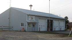 Farmington Township fire hall in Leeper | |
 Leeper Location in Pennsylvania | |
| Coordinates: 41°22′14″N 79°18′20″W / 41.37056°N 79.30556°WCoordinates: 41°22′14″N 79°18′20″W / 41.37056°N 79.30556°W | |
| Country | United States |
| State | Pennsylvania |
| County | Clarion |
| Township | Farmington |
| Area | |
| • Total | 0.53 sq mi (1.36 km2) |
| • Land | 0.53 sq mi (1.36 km2) |
| • Water | 0.0 sq mi (0.0 km2) |
| Elevation | 1,634 ft (498 m) |
| Population (2010) | |
| • Total | 158 |
| • Density | 301/sq mi (116.4/km2) |
| Time zone | UTC-5 (Eastern (EST)) |
| • Summer (DST) | UTC-4 (EDT) |
| ZIP code | 16233 |
| FIPS code | 42-42328 |
| GNIS feature ID | 2630020 |
Leeper is a census-designated place (CDP)[1] located in Farmington Township, Clarion County, in the U.S. state of Pennsylvania. The community is located at the intersections of Pennsylvania Routes 66 and 36 in northern Clarion County. As of the 2010 census the population was 158.[2]
References
- ↑ "Archived copy". Archived from the original on 2013-12-21. Retrieved 2016-07-10.
- ↑ "Geographic Identifiers: 2010 Census Summary File 1 (G001): Leeper CDP, Pennsylvania". U.S. Census Bureau, American Factfinder. Retrieved April 28, 2015.
External links
Municipalities and communities of Clarion County, Pennsylvania, United States | ||
|---|---|---|
| Boroughs | 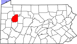 | |
| Townships | ||
| CDPs | ||
| Unincorporated communities | ||
| Footnotes | ‡This populated place also has portions in an adjacent county or counties | |
This article is issued from
Wikipedia.
The text is licensed under Creative Commons - Attribution - Sharealike.
Additional terms may apply for the media files.