Placerville, California
| Placerville, California | ||
|---|---|---|
| City | ||
| City of Placerville | ||
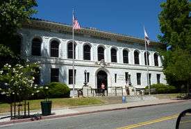 El Dorado County Courthouse | ||
| ||
| Nickname(s): Hangtown[1] | ||
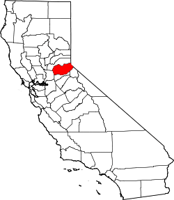
 Location of Placerville in California. | ||
 Placerville, California Location in the United States | ||
| Coordinates: 38°43′47″N 120°47′55″W / 38.72972°N 120.79861°WCoordinates: 38°43′47″N 120°47′55″W / 38.72972°N 120.79861°W[2] | ||
| Country |
| |
| State |
| |
| County | El Dorado | |
| Incorporated | May 13, 1854[3] | |
| Government | ||
| • Mayor | John Clerici[4] | |
| Area[5] | ||
| • Total | 5.81 sq mi (15.05 km2) | |
| • Land | 5.81 sq mi (15.05 km2) | |
| • Water | 0.00 sq mi (0.00 km2) 0.01% | |
| Elevation[1] | 1,867 ft (569 m) | |
| Population (2010) | ||
| • Total | 10,389 | |
| • Estimate (2016)[6] | 10,681 | |
| • Density | 1,837.75/sq mi (709.57/km2) | |
| Time zone | UTC-8 (PST) | |
| • Summer (DST) | UTC-7 (PDT) | |
| ZIP code | 95667[7] | |
| Area code | 530 | |
| FIPS code | 06-57540 | |
| GNIS feature IDs | 277577, 2411433 | |
| Website |
www | |
| Reference no. | 701[8] | |
Placerville (/ˈplæsərvɪl/, PLASS-ər-vil; formerly Old Dry Diggings, Dry Diggings, and Hangtown[9]) is the county seat of El Dorado County, California. The population was 10,389 at the 2010 census, up from 9,610 at the 2000 census. It is part of the Sacramento–Arden-Arcade–Roseville Metropolitan Statistical Area.
History
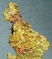
After the discovery of gold at Sutter's Mill in nearby Coloma, California, by James W. Marshall in 1848 sparked the California Gold Rush, the small town now known as Placerville was known as Dry Diggin's after the manner in which the miners moved cartloads of dry soil to running water to separate the gold from the soil. Later in 1849, the town earned its most common historical name, "Hangtown", because of the numerous hangings that had occurred there.[10] According to the museum guide at the Fountain & Tallman Museum, there were only three hangings that occurred after three men on horseback came into town with guns ablaze. The name stuck after that. By about 1850, the temperance league and a few local churches had begun to request that a more friendly name be bestowed upon the town. The name was not changed until 1854 when the City of Placerville was incorporated. At its incorporation Placerville was the third largest town in California. In 1857 the county seat was then moved from Coloma to Placerville, where it remains today.
Placerville was a central hub for the Mother Lode region's mining operations.[11] The town had many services, including transportation (of people and goods), lodging, banking, and had a market and general store. The history of hard-rock mining is evidenced by an open and accessible Gold Bug Park & Mine, now a museum with tours and books.[12]
The Southern Pacific Railroad once had a branch line that extended from Sacramento to Placerville. The track was abandoned in the 1980s. The Camino, Placerville and Lake Tahoe Railroad (now abandoned) also operated an 8-mile (13 km) shortline that operated between Camino, California, and Placerville until June 17, 1986. As of March 29, 2007, 52 miles (84 km) of the right-of-way have been purchased by the city of Folsom, and 18 miles (29 km) of track have been restored. Plans are in motion for a tourist train along the route by 2015.[8]
The town's first post office opened in 1850.[9]
Placerville is now registered as California Historical Landmark #701.[8]
Main Street
Site of the Pony Express
Located on the corner of Main and Sacramento Street is the site of the Pony Express where 80 riders including William, "Buffalo Bill" Cody, relayed mail by horseback between Missouri and Sacramento. The Pony Express ran from April 1860 through June 1861 when the telegraph came into use.
Cary House Hotel
The Cary House Hotel is located at 300 Main Street and was built in 1857. The three-story hotel was built out of brick to help prevent the devastation that was served upon several local hotels that were destroyed during the fires that destroyed a large portion of Placerville in 1857. The Cary House was also the hub of the Wells Fargo stage lines. It's estimated that more than $900 million of gold and silver passed through the doors of the Cary House during the transfer between the Mother Lode and the Nevada Comstock.
In 1908, John Augustus Raffetto bought the Cary House. In 1915, he demolished and rebuilt it with three stories that had fifty-four rooms (fifteen with baths), coffee shop, and dining room. His oldest son, Lloyd Raffetto, renamed it the Raffles Hotel. When the Raffettos sold it, the new owners brought back the name "Cary House."[13][14][15][16]
Historical figures known to have stayed at the hotel include Mark Twain (who used to write for the Mountain Democrat in Placerville), President Ulysses S. Grant and John Studebaker. Hollywood figures, such as actress Bette Davis, have graced the hotel. Most recently, Brooke Shields and Lou Diamond Phillips filmed a movie at the hotel.[17]
Site of the famous Hangman's Tree
California State Historic Landmark #141 indicates the site of the Hangman's Tree located at 305 Main Street. The 1849 hanging of robbers and murderers inspired "Hangtown" one of the town's early names.
Masonic Lodge Building
The Masonic lodge is located at 419 Main Street. The three-story brick building was constructed in 1893. This is the only still standing building that was originally erected with three stories within the Placerville city limits. Prior to the building of the Masonic Lodge, the site was the home of the Nebraska Saloon and an undertaking business.
Placerville Hardware
Placerville Hardware is located at 441 Main Street and is the oldest continuously operating hardware store west of the Mississippi.
The Bell Tower

The Bell Tower located near the center of Main Street was erected in 1865 to alert the fire fighters and townsmen in the event of a fire.
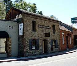
Fountain and Tallman Soda Works
The Fountain and Tallman Soda Works is located at 542 Main Street and is constructed of brick and stone survived the fire of 1856. Spring water obtained from a fresh water spring behind the building was bottled and sold to miners.
Site of John Studebaker Shop
John Studebaker's Shop was located at 543 Main Street. The former automobile maker, used to build wheelbarrows on Main Street Placerville. The wheelbarrows were used by miners during the California Gold Rush. The building no longer exists, but the City of Placerville pays homage to this historic figure by holding a wheelbarrow race during the annual El Dorado County Fair.
Placerville Soda Works Building
The United States Department of the Interior placed the John Pearson Soda Works on the National Register of Historic Places in 1985. This property located at 594 Main Street was purchased in 1859 by ice merchant, John Pearson. The property included a mine that burrowed into a hill. Pearson built a stone building around the mine taking advantage of naturally cool temperature of the mine tunnel to store the ice. Pearson sold many other items including soda water, cream soda and syrups. After his death, Pearson's sons added the second story in 1897 to use as a bottling factory for the burgeoning soda business. The sons later sold the business in 1904 and the new owners renamed the business Placerville Soda Works.
Druid Monument
Corner of Main and Cedar Ravine
The Druid Monument was placed by the fraternal organization on this site in 1926. The monument is in recognition of the first Druid Grove in California.
Site of Old Dry Diggins Mining Camp
Historical Landmark No 475 observes the significance of the site of Old Dry Diggins Mining Camp. The camp was established in 1848 during the California Gold Rush. The camp was located on the banks of the Hangtown Creek and served as a supply center for miners and a transportation hub. The camp inspired, "Dry Diggins", one of the city's historic names.
The Plumado House
The 1 ½ story, Pioneer style, Plumado House, was built sometime around 1860. The house is built into the hillside that was created by mining activity. The lower story is beneath the hillside and has 18 inch thick walls made of hand carved lava. ("Historic Resources inventory", 1985)
The Shakespeare Club
The Shakespeare Club is the oldest continuously active Women's Club in the United States. The club was originally organized in 1897 for the purpose of studying the works of William Shakespeare. The Shakespeare Club was originally located on Union Street; however, due to construction of State Highway 50 the members relocated the building during the summer of 1951 to its present site on Bedford Avenue.
The Bosquit House
The Bosquit House was built around 1900 and was one of the first homes to use concrete material for the building's foundation. The home was built by one of Placerville's more prominent citizens, Archibald Bosquit, who served as the undertaker, tax collector and county sheriff.
A.J. Kennedy House
The A. J. Kennedy House was built in the Classic style in 1878. The home was one of the largest homes built in the area and was frequently described as a "mansion". The home was built and lived in by Andrew Jackson Kennedy, deputy collector for the Internal Revenue Service. ("Historic Resources Inventory.
The Ingram-Atwood House
The Queen Anne Cottage, Ingram-Atwood House, was built around 1870. The house was built by George Ingram, one of the developers of Placerville. The design of this home features the entrance which is located diagonally at the corner of the home. The home was purchased by the Atwood family in 1907. The home was updated after World War II when a front gable was added and the exterior front porch enclosed. ("Historical Resources Inventory").
The Goodrich House
The Goodrich House was built sometime around 1918. The square shaped 1 ½ story Classic Cottage includes a one story extension at the back of the home. A feature of the home site is the retaining wall made of stacked Mariposa Slate that dates to the 1850s. The home was built for Don Goodrich, the Superintendent of Schools in Placer County.
National Register of Historic Places gallery
Placerville has several buildings listed on the National Register of Historic Places; several are noted below.
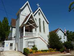
 Fountain-Tallman Soda Works (now the Fountain & Tallman Museum)
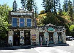
Geography
Placerville is located in the Sierra Nevada foothills where U.S. Route 50 crosses State Route 49. It is the location of three traffic signals along U.S. Route 50, which is otherwise a freeway.
Downtown Placerville is about 1,867 feet (569 m) above sea level,[1] while unincorporated areas of the city range from 1,800 feet (550 m) to nearly 4,000 feet (1,200 m).
According to the United States Census Bureau, the city has a total area of 5.8 square miles (15 km2), over 99% of it land.
Climate
Placerville has cool, frequently wet winters and hot, dry summers, creating a typically Californian Mediterranean climate (Köppen Csa). Average January temperatures are a maximum of 53.4 °F (11.9 °C) and a minimum of 32.5 °F (0.3 °C). Average July temperatures are a maximum of 92.7 °F (33.7 °C) and a minimum of 57.2 °F (14.0 °C). Annually, there are an average of 65.7 days with highs of 90 °F (32 °C) or higher and 61.3 mornings with lows of 32 °F (0 °C) or lower. The record high temperature was 114 °F (46 °C) on July 4, 1911. The record low temperature was 8 °F (−13.3 °C) on December 9, 1972.
Average annual rainfall in Placerville is 38.11 inches (968.0 mm). There are an average of 66 days with measurable rain. The wettest calendar year was 1983 with 74.55 inches (1,893.6 mm) and the driest 1976 with 11.85 inches (301 mm). The most rainfall in one month was 23.29 inches (591.6 mm) in December 1955. The most rainfall in 24 hours was 6.22 inches (158 mm) on February 14, 2000.[18] Although snowfall is rare in Placerville, heavy amounts often fall in the mountains east of the city.
| Climate data for Placerville, California (1915-2005) | |||||||||||||
|---|---|---|---|---|---|---|---|---|---|---|---|---|---|
| Month | Jan | Feb | Mar | Apr | May | Jun | Jul | Aug | Sep | Oct | Nov | Dec | Year |
| Record high °F (°C) | 75 (24) |
78 (26) |
87 (31) |
92 (33) |
104 (40) |
109 (43) |
110 (43) |
109 (43) |
108 (42) |
100 (38) |
83 (28) |
76 (24) |
110 (43) |
| Average high °F (°C) | 53.3 (11.8) |
56.9 (13.8) |
60.2 (15.7) |
66.3 (19.1) |
74.5 (23.6) |
83.7 (28.7) |
92.4 (33.6) |
91.3 (32.9) |
85.5 (29.7) |
74.8 (23.8) |
61.1 (16.2) |
53.9 (12.2) |
71.2 (21.8) |
| Daily mean °F (°C) | 42.8 (6) |
45.8 (7.7) |
48.8 (9.3) |
53.3 (11.8) |
60.3 (15.7) |
67.7 (19.8) |
74.8 (23.8) |
73.6 (23.1) |
68.5 (20.3) |
59.8 (15.4) |
49.0 (9.4) |
43.4 (6.3) |
57.3 (14.1) |
| Average low °F (°C) | 32.4 (0.2) |
34.7 (1.5) |
37.4 (3) |
40.3 (4.6) |
46.0 (7.8) |
51.6 (10.9) |
56.8 (13.8) |
55.9 (13.3) |
51.5 (10.8) |
44.7 (7.1) |
37.1 (2.8) |
32.9 (0.5) |
43.4 (6.4) |
| Record low °F (°C) | 9 (−13) |
15 (−9) |
19 (−7) |
24 (−4) |
29 (−2) |
31 (−1) |
38 (3) |
37 (3) |
33 (1) |
23 (−5) |
21 (−6) |
8 (−13) |
8 (−13) |
| Average rainfall inches (mm) | 7.05 (179.1) |
6.70 (170.2) |
5.85 (148.6) |
3.09 (78.5) |
1.52 (38.6) |
0.46 (11.7) |
0.08 (2) |
0.09 (2.3) |
0.56 (14.2) |
2.12 (53.8) |
4.52 (114.8) |
6.52 (165.6) |
38.56 (979.4) |
| Average snowfall inches (cm) | 1.2 (3) |
0.4 (1) |
0.4 (1) |
0.3 (0.8) |
0 (0) |
0 (0) |
0 (0) |
0 (0) |
0 (0) |
0 (0) |
0 (0) |
0.4 (1) |
2.7 (6.8) |
| Average rainy days | 10 | 10 | 10 | 7 | 4 | 2 | 0 | 1 | 1 | 4 | 7 | 10 | 66 |
| Source: http://www.wrcc.dri.edu/cgi-bin/cliMAIN.pl?caplac+nca | |||||||||||||
Demographics
| Historical population | |||
|---|---|---|---|
| Census | Pop. | %± | |
| 1860 | 2,466 | — | |
| 1870 | 1,562 | −36.7% | |
| 1880 | 1,951 | 24.9% | |
| 1890 | 1,690 | −13.4% | |
| 1900 | 1,748 | 3.4% | |
| 1910 | 1,914 | 9.5% | |
| 1920 | 1,650 | −13.8% | |
| 1930 | 2,322 | 40.7% | |
| 1940 | 3,064 | 32.0% | |
| 1950 | 3,749 | 22.4% | |
| 1960 | 4,439 | 18.4% | |
| 1970 | 5,416 | 22.0% | |
| 1980 | 6,739 | 24.4% | |
| 1990 | 8,355 | 24.0% | |
| 2000 | 9,610 | 15.0% | |
| 2010 | 10,389 | 8.1% | |
| Est. 2016 | 10,681 | [6] | 2.8% |
| U.S. Decennial Census[19] | |||
2010
The 2010 United States Census[20] reported that Placerville had a population of 10,389. The population density was 1,787.3 people per square mile (690.1/km²). The racial makeup of Placerville was 8,716 (83.9%) White, 80 (0.8%) African American, 162 (1.6%) Native American, 98 (0.9%) Asian, 13 (0.1%) Pacific Islander, 867 (8.3%) from other races, and 453 (4.4%) from two or more races. Hispanic or Latino of any race were 1,863 persons (17.9%).
The Census reported that 9,788 people (94.2% of the population) lived in households, 131 (1.3%) lived in non-institutionalized group quarters, and 470 (4.5%) were institutionalized.
There were 4,129 households, out of which 1,254 (30.4%) had children under the age of 18 living in them, 1,607 (38.9%) were opposite-sex married couples living together, 604 (14.6%) had a female householder with no husband present, 250 (6.1%) had a male householder with no wife present. There were 327 (7.9%) unmarried opposite-sex partnerships, and 31 (0.8%) same-sex married couples or partnerships. 1,306 households (31.6%) were made up of individuals and 599 (14.5%) had someone living alone who was 65 years of age or older. The average household size was 2.37. There were 2,461 families (59.6% of all households); the average family size was 2.97.
The population was spread out with 2,277 people (21.9%) under the age of 18, 972 people (9.4%) aged 18 to 24, 2,468 people (23.8%) aged 25 to 44, 2,831 people (27.2%) aged 45 to 64, and 1,841 people (17.7%) who were 65 years of age or older. The median age was 40.4 years. For every 100 females, there were 90.3 males. For every 100 females age 18 and over, there were 86.9 males.
There were 4,541 housing units at an average density of 781.2 per square mile (301.6/km²), of which 4,129 were occupied, of which 2,160 (52.3%) were owner-occupied, and 1,969 (47.7%) were occupied by renters. The homeowner vacancy rate was 3.5%; the rental vacancy rate was 7.8%. 5,023 people (48.3% of the population) lived in owner-occupied housing units and 4,765 people (45.9%) lived in rental housing units.
2000
As of the census[21] of 2000, there were 9,610 people, 4,001 households, and 2,484 families residing in the city. The population density was 1,656.2 people per square mile (639.7/km²). There were 4,242 housing units at an average density of 731.1 per square mile (282.4/km²). The racial makeup of the city was 88.6% White, 0.2% Black or African American, 1.3% Native American, 0.9% Asian, 0.1% Pacific Islander, 5.8% from other races, and 3.1% from two or more races. 12.6% of the population were Hispanic or Latino of any race.
There were 4,001 households out of which 31.3% had children under the age of 18 living with them, 41.7% were married couples living together, 15.9% had a female householder with no husband present, and 37.9% were non-families. 31.2% of all households were made up of individuals and 14.3% had someone living alone who was 65 years of age or older. The average household size was 2.34 and the average family size was 2.90.
In the city, the population was spread out with 25.6% under the age of 18, 8.8% from 18 to 24, 26.2% from 25 to 44, 22.0% from 45 to 64, and 17.4% who were 65 years of age or older. The median age was 38 years. For every 100 females, there were 85.3 males. For every 100 females age 18 and over, there were 78.8 males.
The median income for a household in the city was $36,454, and the median income for a family was $46,875. Males had a median income of $36,711 versus $28,095 for females. The per capita income for the city was $19,151. About 9.3% of families and 12.1% of the population were below the poverty line, including 16.9% of those under age 18 and 4.3% of those age 65 or over.
Government
In the California State Legislature, Placerville is in the 1st Senate District, represented by Republican Ted Gaines,[22] and the 5th Assembly District, represented by Republican Frank Bigelow.[23]
In the United States House of Representatives, Placerville is in California's 4th congressional district, represented by Republican Tom McClintock.[24]
Economy
The region east of Placerville, popularly known as Apple Hill and Pleasant Valley, is becoming a center for wine production. The wine region is officially designated as the El Dorado AVA. The largest wineries in the area are Boeger, Lava Cap and Madrona, but most of the 30 plus wineries surrounding Placerville are family owned and smaller in wine grape and wine production. The region is "renown[ed] for making vibrantly flavorful, distinctly delicious wines, grown in the dramatic elevations of the Sierra Nevada."[25] The area is increasingly a center for sophisticated production of Rhone style wines, noted by El Dorado County having a local chapter of the Rhone Rangers winemaker association.
Formerly known as Anderson Field, the arena and main grandstand that is now known as Placerville Speedway was originally built by the El Dorado County Fair during the winter months of 1956. Constructing a clay racing surface around the perimeter of the football field, Warren Jewitt and Bruno Romani created what was originally known as "Hangtown Speedway". Auto racing took place here for the first time on June 18, 1965.
Since 1965, Placerville Speedway has hosted several racing divisions. The track was cut out of a hillside, giving it higher banking, and covered with a dark red clay racing surface.[26]
Placerville is home to the Mountain Democrat newspaper and Marshall Medical Center.
Transportation

Placerville is served by two major highways. California State Route 49 runs north and south, connecting the city with the other major communities in the Sierra Nevada foothills. U.S. Route 50 heads west to Sacramento and east to South Lake Tahoe. This portion of U.S. Route 50 is a part of the Lincoln Highway.[27]
El Dorado Transit runs public bus service, both local routes connecting Placerville to other populated areas on the western slope and weekday commuter service to/from Sacramento. Amtrak's thruway bus service stops in Placerville along its route connecting Sacramento and South Lake Tahoe.
Placerville is served by the Placerville Airport.[28] A Good Neighbor Airport, it has a 4,200-foot-long (1,300 m) runway, but is not currently served by any commercial air transport.
Culture
Placerville has many old buildings from the Gold Rush days.[29] A walk down Main Street also reveals many historical markers, signifying spots of certain events or persons of importance during this period. Placerville was also on the line of the Pony Express, a short-lived mail carrier service that connected California to the Midwest and East (basically from Sacramento to St. Joseph, Missouri).
Historically, Placerville was often referred to by the name "Hangtown," because of the frequent hangings that occurred in the lawless area. Those traveling in the area can still see the old hangman's platform that was used for public hangings.[30]
The Southern Pacific Transportation Company branch line was purchased from the Union Pacific in 1996 for $14 million by the Joint Powers Authority consisting of Sacramento County, Folsom, and El Dorado County. The line is being restored to run historic excursion trains from Folsom to Placerville on a total of 35 miles (56 km) of track.
Notable people
Over the years many notable and influential people had shops in Placerville, mostly along the now historic Main Street.[31]
Historical persons:
- Horace Bell - lawyer, journalist, historian
- T.J. Caystile - newspaperman
- Oliver Gagliani - photographer
- Henry Hooker - cattle baron
- Mark Hopkins, Jr. - railroad financier
- Edwin Markham - poet
- John Augustus Raffetto - hotelier and banker
- Levi Strauss - clothing maker
- John Studebaker - auto maker
- Jesse Yarnell — newspaperman
Modern notable persons:
- Amy Bruni - Ghost Hunters Investigator
- Dan Crary - bluegrass flat-picking guitarist, retired PhD professor of communications at Cal State Fullerton.
- Toby Hall - baseball player
- Thomas Kinkade - painter
- Larry LaLonde - Primus guitarist
- Bevo LeBourveau - baseball player, later a policeman in Placerville
- Nello Olivo - winemaker
- Michael Raffetto — radio star
- Spider Sabich — ski racer from Kyburz - buried in Placerville
- Ralph Taeger - actor; operated Taeger's Firewood Company in Placerville
- Jerome R. Waldie - U.S. Representative from California
Gallery
 Town Hall
 Placerville bell
References
Notes
- 1 2 3 "Placerville". Geographic Names Information System. United States Geological Survey.
- ↑ "US Gazetteer files: 2010, 2000, and 1990". United States Census Bureau. 2011-02-12. Retrieved 2011-04-23.
- ↑ "California Cities by Incorporation Date". California Association of Local Agency Formation Commissions. Archived from the original (Word) on November 3, 2014. Retrieved April 5, 2013.
- ↑ "Mayor Wilkins". City of Placerville, CA. Retrieved February 26, 2015.
- ↑ "2016 U.S. Gazetteer Files". United States Census Bureau. Retrieved Jun 28, 2017.
- 1 2 "Population and Housing Unit Estimates". Retrieved June 9, 2017.
- ↑ "ZIP Code(tm) Lookup". United States Postal Service. Retrieved November 23, 2014.
- 1 2 "Placerville". Office of Historic Preservation, California State Parks. Retrieved 2012-10-07.
- 1 2 Durham, David L. (1998). California's Geographic Names: A Gazetteer of Historic and Modern Names of the State. Clovis, Calif.: Word Dancer Press. p. 539. ISBN 1-884995-14-4.
- ↑ El Dorado County Visitor's Guide
- ↑ El Dorado County Visitors Authority
- ↑ Hangtown's Gold Bug Park & Mine.
- ↑
- ↑
- ↑ Bidwell, John (1891). A Memorial and Biographical History of Northern California. Chicago: Lewish Publishing. p. 516.
- ↑ "home". Cary House. Retrieved 4 January 2014.
- ↑ "Historic Cary House Hotel". Sierra Nevada GeoTourism MapGuide. Retrieved 31 January 2014.
- ↑ http://www.wrcc.dri.edu/cgi-bin/cliMAIN.pl?ca6960
- ↑ "Census of Population and Housing". Census.gov. Retrieved June 4, 2015.
- ↑ "2010 Census Interactive Population Search: CA - Placerville city". U.S. Census Bureau. Retrieved July 12, 2014.
- ↑ "American FactFinder". United States Census Bureau. Retrieved 2008-01-31.
- ↑ "Senators". State of California. Retrieved April 5, 2013.
- ↑ "Members Assembly". State of California. Retrieved April 5, 2013.
- ↑ "California's 4th Congressional District - Representatives & District Map". Civic Impulse, LLC. Retrieved March 2, 2013.
- ↑ El Dorado Winery Association
- ↑ http://www.placervillespeedway.com/history
- ↑ A Lincoln Highway route marker is embedded in the front wall of a building at 564 Main Street.
- ↑ "Archived copy". Archived from the original on March 30, 2010. Retrieved April 22, 2010.
- ↑ Historical buildings and monuments in El Dorado County
- ↑ El Dorado, County Visitor's Guide
- ↑ Historic Main Street, Placerville.
Sources
External links
| Wikimedia Commons has media related to Placerville, California. |
- Official website

- The Mountain Democrat (local newspaper)
- Placerville Downtown Association
- Western Slope Health Center
- Marshall Medical Center
- Placerville California Weather
- Hangtown Gold Bug Park & Mine
- El Dorado Western Railway Foundation blog The railway is restoring the Diamond & Caldor No. 4 Shay locomotive at the El Dorado County Historical Museum
- Hangtown Kennel Club