Folsom, California
| City of Folsom | |
|---|---|
| City | |
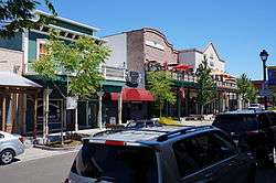 Historic Sutter Street | |
| Motto(s): "Distinctive by Nature"[1] | |
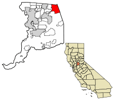 Location of Folsom in Sacramento County, California. | |
 City of Folsom Location in the United States | |
| Coordinates: 38°40′20″N 121°9′28″W / 38.67222°N 121.15778°WCoordinates: 38°40′20″N 121°9′28″W / 38.67222°N 121.15778°W | |
| Country | United States |
| State | California |
| County | Sacramento |
| Incorporated | April 20, 1946[2] |
| Government | |
| • Mayor | Andy Morin[3] |
| Area[4] | |
| • Total | 30.07 sq mi (77.87 km2) |
| • Land | 27.71 sq mi (71.77 km2) |
| • Water | 2.35 sq mi (6.10 km2) 9.69% |
| Elevation[5] | 220 ft (67 m) |
| Population (2010)[6] | |
| • Total | 72,203 |
| • Estimate (2016)[7] | 77,271 |
| • Density | 2,788.56/sq mi (1,076.65/km2) |
| Time zone | UTC-8 (PST) |
| • Summer (DST) | UTC-7 (PDT) |
| ZIP codes | 95630, 95671, 95763 |
| Area code(s) | 916 |
| FIPS code | 06-24638 |
| GNIS feature IDs | 277516, 2410516 |
| Website |
ci |
Folsom is a city in Sacramento County, California, United States. It is commonly known for Folsom Prison, the song "Folsom Prison Blues" and Folsom Lake. The population was 72,203 at the 2010 census.
Folsom is part of the Sacramento−Arden-Arcade−Roseville Metropolitan Statistical Area.
History
Folsom is named for Joseph Libbey Folsom who purchased Rancho Rio de los Americanos from the heirs of San Francisco merchant William Alexander Leidesdorff, and laid out the town called Granite City, mostly occupied by gold miners seeking their fortune in the Sierra Nevada foothills. Though few amassed a great deal of wealth, the city prospered due to Joseph Folsom's lobbying to get a railway to connect the town with Sacramento. Joseph died in 1855, and Granite City was later renamed Folsom in his honor. The railway was abandoned in the 1980s[8] but opened up as the terminus of the Gold Line of Sacramento Regional Transit District's light rail service in 2005. A few former gold-rush era towns are located within the city limits of Folsom, including Prairie City, Salmon Falls, and Mormon Island (though these towns no longer exist).
Folsom hosted a significant Chinese American community when it was first incorporated, but arsonists burned Folsom's Chinatown in March 1886, driving Chinese Americans out of town.[9]
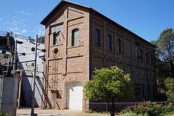
The establishment of Folsom Prison came in 1880, when the Livermore family made an agreement with the state to donate land for the prison in exchange for prison labor. They planned to build a hydro-electric dam from the American River for a sawmill. Though the sawmill did not work out, the Livermores soon realized that the natural force of running water could provide enough power to transmit to Sacramento, and the Folsom Powerhouse, now a National Historic Landmark, was opened. At the time it was opened, it had the longest overhead run of electricity (22 miles) in the country. The powerhouse operated until 1952.
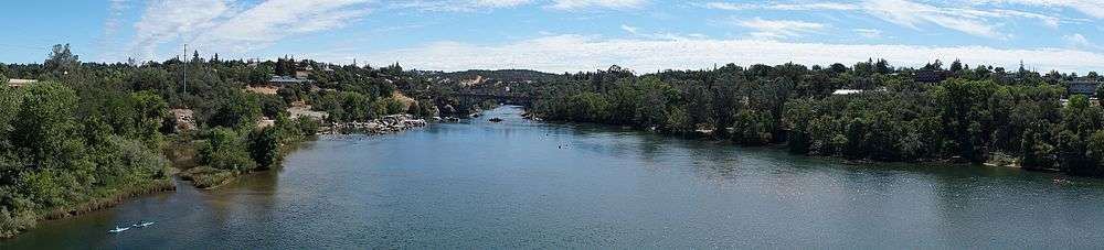
Folsom Dam was built in 1956, providing much-needed flood control and water rights for the Sacramento Valley. The creation of this dam also created one of the most popular lakes in Northern California, Folsom Lake. The dam is located on the southwest corner of the lake. The lake is an estimated 4.8 miles (7.7 km) from Granite Bay to the most southern point of Folsom Lake.
Folsom is home to Folsom Lake College, Folsom Dam, Folsom Lake, Folsom High School, Vista del Lago High School and a historic district. Folsom is also home to the largest private employer in the Sacramento area, Intel.
Geography
According to the United States Census Bureau, the city has a total area of 34 square miles (88 km2), of which, 31.9 square miles (83 km2) of it is land and 2.4 square miles (6.2 km2) of it (9.69%) is water, primarily accounted for by Folsom Lake. Folsom is located in the foothills of the Sierra Nevada.
Folsom's climate is characterized by long, hot, dry summers and cool, rainy winters.
| Climate data for Folsom, California (Folsom Dam), 1981–2010 normals | |||||||||||||
|---|---|---|---|---|---|---|---|---|---|---|---|---|---|
| Month | Jan | Feb | Mar | Apr | May | Jun | Jul | Aug | Sep | Oct | Nov | Dec | Year |
| Average high °F (°C) | 54 (12) |
61 (16) |
65 (18) |
72 (22) |
81 (27) |
89 (32) |
94 (34) |
94 (34) |
88 (31) |
79 (26) |
62 (17) |
54 (12) |
74 (23) |
| Average low °F (°C) | 38 (3) |
43 (6) |
46 (8) |
48 (9) |
52 (11) |
58 (14) |
61 (16) |
60 (16) |
58 (14) |
54 (12) |
44 (7) |
39 (4) |
50 (10) |
| Average precipitation inches (mm) | 3.70 (94) |
4.63 (117.6) |
4.65 (118.1) |
1.74 (44.2) |
.67 (17) |
.38 (9.7) |
.06 (1.5) |
.11 (2.8) |
.62 (15.7) |
1.46 (37.1) |
3.96 (100.6) |
3.83 (97.3) |
25.80 (655.3) |
| Source: [10] | |||||||||||||
Demographics
| Historical population | |||
|---|---|---|---|
| Census | Pop. | %± | |
| 1890 | 609 | — | |
| 1950 | 1,690 | — | |
| 1960 | 3,925 | 132.2% | |
| 1970 | 5,810 | 48.0% | |
| 1980 | 11,003 | 89.4% | |
| 1990 | 29,802 | 170.9% | |
| 2000 | 51,884 | 74.1% | |
| 2010 | 72,203 | 39.2% | |
| Est. 2016 | 77,271 | [7] | 7.0% |
| U.S. Decennial Census[11] | |||
2010
The 2010 United States Census[12] reported that Folsom had a population of 72,203. The population density was 2,971.2 people per square mile (1,147.2/km²). The racial makeup of Folsom was 53,627 (74.3%) White, 4,140 (5.7%) African American, 427 (0.6%) Native American, 9,000 (12.5%) Asian, 173 (0.2%) Pacific Islander, 1,818 (2.5%) from other races, and 3,018 (4.2%) from two or more races. Hispanic or Latino of any race were 8,064 persons (11.2%).
The Census reported that 65,243 people (90.4% of the population) lived in households, 188 (0.3%) lived in non-institutionalized group quarters, and 6,772 (9.4%) were institutionalized.
There were 24,951 households, out of which 9,796 (39.3%) had children under the age of 18 living in them, 14,399 (57.7%) were opposite-sex married couples living together, 2,195 (8.8%) had a female householder with no husband present, 1,006 (4.0%) had a male householder with no wife present. There were 1,150 (4.6%) unmarried opposite-sex partnerships, and 137 (0.5%) same-sex married couples or partnerships. 5,788 households (23.2%) were made up of individuals and 1,930 (7.7%) had someone living alone who was 65 years of age or older. The average household size was 2.61. There were 17,600 families (70.5% of all households); the average family size was 3.13.
The population was spread out with 17,570 people (24.3%) under the age of 18, 5,344 people (7.4%) aged 18 to 24, 23,022 people (31.9%) aged 25 to 44, 19,358 people (26.8%) aged 45 to 64, and 6,909 people (9.6%) who were 65 years of age or older. The median age was 37.6 years. For every 100 females, there were 114.1 males. For every 100 females age 18 and over, there were 117.9 males.
There were 26,109 housing units at an average density of 1,074.4 per square mile (414.8/km²), of which 17,442 (69.9%) were owner-occupied, and 7,509 (30.1%) were occupied by renters. The homeowner vacancy rate was 1.9%; the rental vacancy rate was 5.2%. 47,982 people (66.5% of the population) lived in owner-occupied housing units and 17,261 people (23.9%) lived in rental housing units.
2000
As of the census[13] of 2000, there were 51,884 people, 17,196 households, and 12,518 families residing in the city. The population density was 2,386.7 people per square mile (921.5/km²). There were 17,968 housing units at an average density of 826.5 per square mile (319.1/km²). The racial makeup of the city was 77.89% Caucasian, 5.99% African American, 0.58% Native American, 7.19% Asian, 0.19% Pacific Islander, 4.71% from other races, and 3.43% from two or more races. Hispanic or Latino of any race were 9.47% of the population.
There were 17,196 households out of which 39.1% had children under the age of 18 living with them, 61.7% were married couples living together, 8.0% had a female householder with no husband present, and 27.2% were non-families. 21.8% of all households were made up of individuals and 7.1% had someone living alone who was 65 years of age or older. The average household size was 2.61 and the average family size was 3.08.
In the city, the population was spread out with 24.2% under the age of 18, 6.6% from 18 to 24, 39.0% from 25 to 44, 21.4% from 45 to 64, and 8.8% who were 65 years of age or older. The median age was 36 years. For every 100 females, there were 123.4 males. For every 100 females age 18 and over, there were 131.0 males.
According to a 2007 estimate, the median income for a household in the city was $87,542, and the median income for a family was $109,032.[14] Males had a median income of $60,616 versus $42,434 for females. The per capita income for the city was $30,210. About 2.6% of families and 7.3% of the population were below the poverty line, including 4.1% of those under age 18 and 4.3% of those age 65 or over.
Government
In the California State Legislature, Folsom is in the 1st Senate District, represented by Republican Ted Gaines, and in the 6th Assembly District, represented by Republican Kevin Kiley.[15]
In the United States House of Representatives, Folsom is in California's 7th congressional district, represented by Democrat Ami Bera.[16]
Public safety
Folsom is protected by the Folsom Police Department and the Folsom Fire Department. The police department is a full service agency with Operations, Administration, and Investigations Division. The Patrol Bureau of the Operations Division consists of patrol, traffic, canines, bicycles, SWAT and school resource officers. The Investigations Bureau investigates persons, property, juvenile services and narcotics.
Chief Cynthia Renaud was appointed in 2011 to oversee the 73 officers and 26 professional staff employed by the police department. The police are augmented by a reserve officer program, an explorer scout program, and an award-winning volunteer program named Citizen's Assisting Public Safety (CAPS).
Folsom experiences a very low crime rate, a majority of which are property crimes. The FBI's Uniformed Crime Report consistently shows Folsom as one of the lowest crime rates in the State of California. Both the Folsom Police Department and Folsom Fire Department utilize Nixle.com, Facebook, and Twitter to keep residents and business owners informed of emergencies and crime trends.
Economy
Top employers
According to the City's 2014 Comprehensive Annual Financial Report,[17] the top employers in the city are:
| # | Employer | # of Employees |
|---|---|---|
| 1 | Intel | 6,300 |
| 2 | California State Prison, Sacramento | 1,621 |
| 3 | Folsom State Prison | 1,024 |
| 4 | Folsom Cordova Unified School District | 821 |
| 5 | Verizon | 732 |
| 6 | Mercy Hospital of Folsom | 663 |
| 7 | California ISO | 557 |
| 8 | Micron Technology | 480 |
| 9 | City of Folsom | 415 |
| 10 | Walmart | 310 |
Bike Trails
Folsom is home to 32 miles of bike trails including the Humbug-Willow Creek Trail. This particular trail system follows both Humbug and Willow Creeks, and passes through several traces of dredge tailings and riparian forests. Other trails include the Folsom Rail Trail (along Folsom Boulevard), The Folsom Lake Trail (to connect El Dorado Hills with Lake Natoma), and the Oak Parkway Trail (between Blue Ravine Road and East Natoma Street).
Folsom is also the endpoint of the American River Bike Trail, which starts in Sacramento.
Folsom Lake Recreational Area has a wide range of off-road biking and hiking trails. A few of the more popular trails include the American River Trail, Pioneer Express Trail, Sweetwater Trail, and Rattlesnake Bar-Horseshoe Bar Trail. These trails are more strenuous and range from 2 miles to 10 mile hiking trails, and offer amazing views of Folsom Lake, surrounding trees and vegetation, as well as wildlife.
Bridges
Bridges located in Folsom include the Lake Natoma Crossing; the Rainbow Bridge, a historic truss bridge; and Folsom Lake Crossing. There is also a pedestrian bridge over East Bidwell Street that opened on November 6, 2010 as part of a new segment on the Humbug-Willow Creek Trail called the Johnny Cash Trail and a Johnny Cash Bridge crossing over near the intersection of Folsom Lake Crossing and East Natoma that was unveiled on October 4, 2014.
Government and infrastructure
The California Department of Corrections and Rehabilitation prisons Folsom State Prison and California State Prison, Sacramento are located in Folsom.
The United States Postal Service operates the Folsom Post Office.[18]
The Sacramento Regional Transit District extended the light rail train system to Folsom via an extension to the Gold Line in October 2005, providing direct service to Downtown Sacramento.
Notable people
- Jake Browning, Washington Huskies quarterback
- Peter Camejo, Green Party activist
- Spider Jorgensen, Major League Baseball player
- Aspen Ladd, MMA fighter currently fighting in UFC
- Jordan Richards, New England Patriots safety
- Dmitry Tursunov, tennis player. representing Russia in 2008 Olympics
Education
Folsom Lake College is a public community college which is part of the Los Rios Community College District.
Folsom Cordova Unified School District operates public schools. Folsom High School and Vista del Lago High School are located in Folsom. There are two middle schools in Folsom: Folsom Middle School and Sutter Middle School.
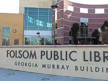
The city operates the Folsom Public Library, located in the Georgia Murray Building.[19]
Adjacent areas
Places adjacent to Folsom, California | ||||||||||
|---|---|---|---|---|---|---|---|---|---|---|
| ||||||||||
Sister cities

Arts
- Home to FreeFall Stage, the longest currently running community theatre in the city, established in 2001. (freefallstage.com)
- Home to the Ballet Folsom
- Home to Hawkins School of Performing Arts, the official school of the Ballet Folsom
- Home to The Folsom Symphony[20]
- Home of the Award-winning Folsom High School music program[21]
- Home to the Harris Center for the Arts
See also
References
- ↑ "City of Folsom, California". City of Folsom, California. Retrieved August 11, 2012.
- ↑ "California Cities by Incorporation Date". California Association of Local Agency Formation Commissions. Archived from the original (Word) on November 3, 2014. Retrieved August 25, 2014.
- ↑ "City Council". City of Folsom. Retrieved 20 April 2016.
- ↑ "2016 U.S. Gazetteer Files". United States Census Bureau. Retrieved Jul 19, 2017.
- ↑ "Folsom". Geographic Names Information System. United States Geological Survey. Retrieved January 4, 2015.
- ↑ "Annual Estimates of the Resident Population for Incorporated Places: April 1, 2010 to July 1, 2015". Archived from the original on June 2, 2016. Retrieved July 2, 2016.
- 1 2 "Population and Housing Unit Estimates". Retrieved June 9, 2017.
- ↑ "Nimbus to Folsom". AbandonedRails.com. Retrieved 2008-10-12.
- ↑ http://www.uvm.edu/~jloewen/sundowntownsshow.php?id=1054
- ↑ "FOLSOM DAM, CALIFORNIA - Climate Summary". www.wrcc.dri.edu.
- ↑ "Census of Population and Housing". Census.gov. Archived from the original on May 12, 2015. Retrieved June 4, 2015.
- ↑ "2010 Census Interactive Population Search: CA - Folsom city". U.S. Census Bureau. Retrieved July 12, 2014.
- ↑ "American FactFinder". United States Census Bureau. Archived from the original on September 11, 2013. Retrieved 2008-01-31.
- ↑ Bureau, U.S. Census. "American FactFinder - Results". factfinder.census.gov.
- ↑ "Statewide Database". UC Regents. Retrieved November 29, 2014.
- ↑ "California's 7th Congressional District - Representatives & District Map". Civic Impulse, LLC. Retrieved March 9, 2013.
- ↑ City of Folsom CAFR 2014
- ↑ "Folsom". United States Postal Service. Retrieved December 8, 2011.
- ↑ "Library Locations & Hours". Folsom Public Library. Retrieved June 18, 2017.
- ↑ http://www.folsomsymphony.com/
- ↑ "Folsom High School Music Boosters". Folsom High School Music Boosters.
External links
| Wikivoyage has a travel guide for Folsom. |
- Official website
- Historic Downtown Folsom
- Folsom Website - Bike Trails of Folsom
- MyFolsom - Folsom Community Website
Municipalities and communities of Sacramento County, California, United States | ||
|---|---|---|
| Cities | 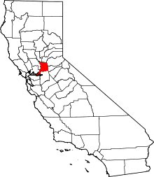 | |
| CDPs | ||
| Unincorporated communities | ||
| Ghost towns | ||