Henry Hudson Parkway
| |
|---|---|
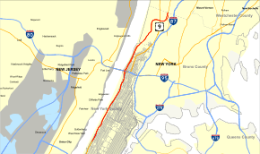 Map of New York City with Henry Hudson Parkway highlighted in red | |
| Route information | |
| Maintained by NYSDOT, NYCDOT, NYC Parks, MTA, Amtrak, and PANYNJ | |
| Length | 11.05 mi[1] (17.78 km) |
| Existed | 1937[2] – present |
| Component highways |
|
| Restrictions | No commercial vehicles |
| Major junctions | |
| From |
|
| |
| North end |
|
| Location | |
| Counties | New York, Bronx |
| Highway system | |

The Henry Hudson Parkway is an 11.05-mile (17.78 km) parkway in New York City. The southern terminus is in Manhattan at 57th Street on the northbound side and 56th Street on the southbound side, where the parkway continues south as the West Side Highway.[3] It is often erroneously referred to as the West Side Highway throughout its entire course in Manhattan. The northern terminus is at the Bronx–Westchester county boundary, where it continues north as the Saw Mill River Parkway. All but the northernmost mile of the road is co-signed as New York State Route 9A (NY 9A). In addition, the entirety of the parkway is designated New York State Route 907V (NY 907V), an unsigned reference route.[3]
The owners of the parkway are the New York State Department of Transportation, New York City Department of Transportation, New York City Department of Parks and Recreation, Metropolitan Transportation Authority, Amtrak, and Port Authority of New York and New Jersey. The Henry Hudson Parkway was created by the Henry Hudson Parkway Authority, which was run by "master builder" Robert Moses. The highway itself was constructed from 1934–1937.
Route description
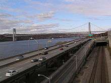
The Henry Hudson Parkway begins in Midtown at 57th Street on the northbound side and 56th on the southbound side, which also serves as the north end of the West Side Highway and the last remaining section of the West Side Highway's predecessor, the Miller Highway.[3] The junction is numbered as exit 8, continuing the numbering scheme used on the West Side Highway. It heads northward along the west side of Manhattan, connecting to West 79th Street with a large interchange and to other surface streets with more intermittent exits along the way. The parkway continues in a northerly direction, running almost parallel to Riverside Drive north of West 158th Street. It passes under Interstate 95 (I-95) and the George Washington Bridge as it continues its progression through Fort Washington Park, Fort Tryon Park, and Inwood Hill Park. It then runs northward across the Henry Hudson Bridge into the Bronx.
Upon entering the Bronx, the parkway passes through Spuyten Duyvil and Riverdale as it continues northward, edging slightly to the northeast. Between Exits 20 and 22, Riverdale Avenue is split into service roads along the parkway. At exit 23, NY 9A leaves the parkway for U.S. Route 9 (US 9) while the parkway enters Van Cortlandt Park. Soon after it enters the park, the parkway has an interchange with the Mosholu Parkway, which connects it to I-87. Less than a mile farther on, the parkway becomes the Saw Mill River Parkway as it enters Westchester County.
History

The Parkway was completed on October 12, 1937, under New York master builder Robert Moses. It cost $109 million, twice as expensive as the $49 million Hoover Dam that was built in the same period. The Parkway was part of Moses's "West Side Improvement" and included covering the New York Central Railroad's West Side Line, creating the Freedom Tunnel. The covered portion is partially used for the highway and also expands the Riverside Park designed by Frederick Law Olmsted.[2]

| Wikinews has related news: NYC Henry Hudson highway retaining wall collapses |
On May 12, 2005, part of a retaining wall at Castle Village collapsed onto the northbound lanes of the parkway, just north of the George Washington Bridge, shutting it down shortly before rush hour. The clean-up began quickly, and the road re-opened on May 15.[4]
Future
The Henry Hudson Parkway is a candidate for designation as a New York State Scenic Byway, the first in New York City. At the request of the Henry Hudson Parkway Task Force, in 2005 the New York Metropolitan Transportation Council approved funding to develop a comprehensive corridor management plan, a requirement for its designation.[2]
Exit list
| County | Location | mi[1][5][6] | km | Exit | Destinations | Notes |
|---|---|---|---|---|---|---|
| Manhattan | Riverside South | 0.00 | 0.00 | – | Continuation beyond 72nd Street | |
| – | West 72nd Street / Riverside Boulevard | Northbound entrance only; exit closed on July 8, 2007[7] | ||||
| Riverside Park | 0.20– 0.50 | 0.32– 0.80 | – | West 79th Street – Boat Basin | Signed as 10A (79th Street) and 10B (Boat Basin) northbound | |
| 1.29 | 2.08 | – | West 95th Street (south) / West 96th Street (north) | Interchange also includes northbound u-turn | ||
| Manhattanville | 2.30– 3.30 | 3.70– 5.31 | 12 | West 125th Street | ||
| Hamilton Heights | 4.00– 4.50 | 6.44– 7.24 | 13 | West 158th Street | ||
| Fort Washington Park | 4.80– 5.30 | 7.72– 8.53 | 14 | No southbound signage for West 178th Street | ||
| 4.90– 5.70 | 7.89– 9.17 | 15 | Riverside Drive | Southbound access is via exit 14 | ||
| Fort Tryon Park | 6.40 | 10.30 | 16 | Fort Tryon Park, Cloisters | Northbound exit and entrance | |
| Inwood Hill Park | 6.60– 7.70 | 10.62– 12.39 | 17 | Dyckman Street | ||
| Spuyten Duyvil Creek (Harlem River Ship Canal) | 7.40– 7.80 | 11.91– 12.55 | Henry Hudson Bridge ($6.00 Toll-by-Mail, $2.64 E-ZPass) | |||
| The Bronx | Spuyten Duyvil | 7.90 | 12.71 | 18 | Kappock Street | No entrance ramps |
| 8.10– 8.40 | 13.04– 13.52 | 19 | West 232nd Street | |||
| Riverdale | 8.55 | 13.76 | 20 | West 237th Street (south) / West 239th Street (north) | ||
| 8.80– 9.20 | 14.16– 14.81 | 21 | West 246th Street / West 250th Street (north) | No southbound entrance | ||
| 9.64 | 15.51 | 22 | West 254th Street (south) / West 253rd Street (north) / Riverdale Avenue | |||
| Fieldston | 9.70 | 15.61 | – | Fieldston Road | Southbound entrance only | |
| 9.80– 10.10 | 15.77– 16.25 | 23 | Northern terminus of concurrency with NY 9A; signed as exits 23A (south) and 23B (north) northbound | |||
| Van Cortlandt Park | 10.30– 10.90 | 16.58– 17.54 | 24 | I-87 not signed northbound | ||
| 11.05 | 17.78 | – | Continuation into Westchester County | |||
1.000 mi = 1.609 km; 1.000 km = 0.621 mi
| ||||||
See also
.svg.png)
References
- 1 2 "2011 Traffic Volume Report for New York State" (PDF). New York State Department of Transportation. September 25, 2012. p. 256. Retrieved April 22, 2013.
- 1 2 3 Anderson, Steve. "Henry Hudson Parkway (NY 9A)". NYCRoads. Retrieved March 18, 2010.
- 1 2 3 New York State Department of Transportation (2003). LIST OF STATE ROUTES IN NEW YORK COUNTY (PDF). Retrieved January 15, 2017.
- ↑ "Board of Inquiry Report – Castle Village Retaining Wall Collapse" (PDF). New York City Department of Buildings. April 2007. Archived from the original (PDF) on May 24, 2011. Retrieved April 2, 2010.
- ↑ Google. "January 5, 2015" (Map). Google Maps. Google.
- ↑
- "Bronx County Inventory Listing" (CSV). New York State Department of Transportation. August 7, 2015. Retrieved September 5, 2017.
- "New York County Inventory Listing" (CSV). New York State Department of Transportation. August 7, 2015. Retrieved September 5, 2017.
- ↑ "Henry Hudson Exit Ramp at 72nd Street to be Closed" (Press release). New York City Department of Transportation. July 5, 2007. Retrieved April 1, 2010.
External links
| Wikimedia Commons has media related to Henry Hudson Parkway. |
- Henry Hudson Parkway at Alps' Roads
- Background on the parkway's history and the scenic byway initiative
- Historic American Engineering Record (HAER) No. NY-334, "Henry Hudson Parkway, Extending 11.2 miles from West 72nd Street to Bronx-Westchester border, New York, New York County, NY", 94 photos, 220 data pages, 9 photo caption pages