Garston and Halewood (UK Parliament constituency)
Coordinates: 53°21′29″N 2°52′12″W / 53.358°N 2.870°W
| Garston and Halewood | |
|---|---|
|
Borough constituency for the House of Commons | |
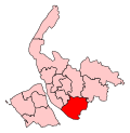 Boundary of Garston and Halewood in Merseyside. | |
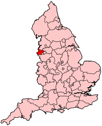 Location of Merseyside within England. | |
| County | Merseyside |
| Electorate | 71,618 (December 2010)[1] |
| Current constituency | |
| Created | 2010 |
| Member of parliament | Maria Eagle (Labour) |
| Number of members | One |
| Created from | Liverpool Garston, Knowsley South |
| Overlaps | |
| European Parliament constituency | North West England |
Garston and Halewood is a constituency[n 1] created in 2010 represented in the House of Commons of the UK Parliament since 2010 by Maria Eagle of the Labour Party.[n 2]
History
- Creation
The seat was created for the 2010 general election during the Boundary Commission for England's review of constituencies.
- Political history
The 2015 re-election of frontbencher Maria Eagle (Lab) made the seat the 11th safest of Labour's 232 seats by percentage of majority.[2]
Boundaries
The City of Liverpool wards of Allerton and Hunts Cross, Belle Vale, Cressington, Speke-Garston, and Woolton, and the Metropolitan Borough of Knowsley wards of Halewood North, Halewood South, and Halewood West. The boundaries have been drawn to date almost square, favouring neither riverside nor inland reach.
The constituency covers most of the previous Liverpool Garston (part of the city of Liverpool), together with the most southerly part of the borough of Knowsley (previously in the Knowsley South constituency).
Constituency profile

Two parts of the political division are green — land surrounding its airport (including the National Trust for Places of Historic Interest or Natural Beauty's archetypal Tudor Speke Hall and grounds) and in the north east, parts of Hough Green and Tarbock Green. The remainder is urban and forms the southern tip of the Merseyside metropolitan county (of mid-size among the 1974-enacted units). The constituency as drawn stretches along the most up-river part of the Mersey Estuary before its brief start between Cheshire and the remainder of its former county of Lancashire, on a near-flat riverside. The history of the City of Liverpool (right) bank of the Mersey witnessed in the late 20th century the ceasing of shipbuilding and a sharp decline in trade, rail distribution and manufacturing prompting mass unemployment. Its now-modest socially rented housing stock alleviated overcrowding of Liverpool. The seat is centred approximately 5 miles (8.0 km) from the city centre.
Deprivation is low for the metropolitan county and marginally higher than the region as a whole. As at the 2011 census 60% of housing was owner-occupied (compared to 64.5% in the North West of England region). At the same census 9.1% of households were deprived in three or the maximum of four dimensions measured by the ONS — in the region the figure is 7.0%.[3]
Members of Parliament
| Election | Member[4][5] | Party | |
|---|---|---|---|
| 2010 | Maria Eagle | Labour | |
Elections
Elections in the 2010s
| Party | Candidate | Votes | % | ± | |
|---|---|---|---|---|---|
| Labour | Maria Eagle | 41,599 | 77.7 | +8.6 | |
| Conservative | Adam Marsden | 9,450 | 17.7 | +4.0 | |
| Liberal Democrat | Anna Martin | 1,723 | 3.2 | -1.5 | |
| Green | Lawrence Brown | 750 | 1.4 | -2.1 | |
| Majority | 32,149 | 59.9 | +4.4 | ||
| Turnout | 53,665 | 71.5 | +5.4 | ||
| Labour hold | Swing | ||||
| Party | Candidate | Votes | % | ± | |
|---|---|---|---|---|---|
| Labour | Maria Eagle | 33,839 | 69.1 | +9.6 | |
| Conservative | Martin Williams | 6,693 | 13.7 | -2.5 | |
| UKIP | Carl Schears | 4,482 | 9.2 | +5.6 | |
| Liberal Democrat | Anna Martin | 2,279 | 4.7 | -15.5 | |
| Green | Will Ward | 1,690 | 3.5 | +3.5 | |
| Majority | 27,146 | 55.4 | +16.0 | ||
| Turnout | 48,983 | 66.1 | +6.0 | ||
| Labour hold | Swing | +6.0 | |||
| Party | Candidate | Votes | % | ± | |
|---|---|---|---|---|---|
| Labour | Maria Eagle* | 25,493 | 59.5 | +1.6 | |
| Liberal Democrat | Paula Keaveney | 8,616 | 20.1 | -9.9 | |
| Conservative | Richard Downey | 6,908 | 16.1 | +6.3 | |
| UKIP | Tony Hammond | 1,540 | 3.6 | +1.8 | |
| Respect | Diana Raby | 268 | 0.6 | +0.6 | |
| Majority | 16,877 | 39.4 | |||
| Turnout | 42,825 | 60.1 | +6.8 | ||
| Labour hold | Swing | 5.7% | |||
- * Served as an MP in the 2005–2010 Parliament
See also
Notes and references
- Notes
- ↑ A borough constituency (for the purposes of election expenses and type of returning officer)
- ↑ As with all constituencies, the constituency elects one Member of Parliament (MP) by the first past the post system of election at least every five years.
- References
- ↑ "Electorate Figures - Boundary Commission for England". 2011 Electorate Figures. Boundary Commission for England. 4 March 2011. Archived from the original on 6 November 2010. Retrieved 13 March 2011.
- ↑ List of Labour MPs elected in 2015 by % majority UK Political.info. Retrieved 2017-01-29
- ↑ Parish: Key Statistics: Population. (2011 census) Retrieved 2016-05-04.
- ↑ Leigh Rayment's Historical List of MPs – Constituencies beginning with "G" (part 1)
- ↑ General Election Results from the Electoral Commission
- ↑
- ↑ "Election Data 2015". Electoral Calculus. Archived from the original on 17 October 2015. Retrieved 17 October 2015.
- ↑ "Garston & Halewood". BBC News. Retrieved 10 May 2015.
- ↑ "Election Data 2010". Electoral Calculus. Archived from the original on 26 July 2013. Retrieved 17 October 2015.