List of Farm to Market Roads in Texas (2600–2699)
|
Texas Farm to Market Road and Ranch to Market Road markers | |
| Highway names | |
|---|---|
| Interstates | Interstate Highway X (IH-X, I-X) |
| US Highways | U.S. Highway X (US X) |
| State | State Highway X (SH X) |
| Loops: | Loop X |
| Spurs: | Spur X |
| Farm or Ranch to Market Roads: |
Farm to Market Road X (FM X) Ranch-to-Market Road X (RM X) |
| Park Roads: | Park Road X (PR X) |
| System links | |
Farm to Market Roads in Texas are owned and maintained by the Texas Department of Transportation.
RM 2600
| |
|---|---|
| Location | Reagan County |
| Length | 12.493 mi[1] (20.106 km) |
| Existed | May 7, 1974[1]–present |
FM 2600
| |
|---|---|
| Location | Nolan County |
| Existed | November 25, 1959–July 26, 1963 |
Farm to Market Road 2600 (FM 2600) is a former highway that was located in Nolan County. No highway currently uses the FM 2600 designation.
FM 2600 was designated in 1959, from FM 608 at Maryneal southward at a distance of 4.0 miles (6.4 km). The highway was cancelled in 1963, with the mileage being transferred to FM 1170.[2]
FM 2601
| |
|---|---|
| Location | Bell County |
| Length | 5.738 mi[3] (9.234 km) |
| Existed | 1959[3]–present |
Farm to Market Road 2601 (FM 2601) is located entirely in Bell County.
FM 2601 begins at an intersection with Moody-Leon Road / Buckhorn Lane in Meador Grove. The highway travels in a generally eastern direction, turning south at Munz Road, before turning back east at FM 2409. FM 2601 continues to run in an eastern direction, ending at an intersection with SH 317. The highway's route is entirely rural, running through farming areas.
FM 2601 was designated in 1959 along the current route.
- Junction list
The entire route is in Bell County.
| Location | mi[4] | km | Destinations | Notes | |
|---|---|---|---|---|---|
| | 0.0 | 0.0 | Moody-Leon Road / Buckhorn Lane | ||
| | 3.9 | 6.3 | |||
| | 5.7 | 9.2 | |||
| 1.000 mi = 1.609 km; 1.000 km = 0.621 mi | |||||
FM 2602
| |
|---|---|
| Location | Bosque County |
| Length | 9.511 mi[5] (15.306 km) |
| Existed | 1959[5]–present |
FM 2603
| |
|---|---|
| Location | Falls and McLennan counties |
| Length | 4.67 mi[6] (7.52 km) |
| Existed | 1959[6]–present |
FM 2604
| |
|---|---|
| Location | Hill County |
| Length | 2.463 mi[7] (3.964 km) |
| Existed | 1959[7]–present |
FM 2605
| |
|---|---|
| Location | Gregg County |
| Length | 2.447 mi[8] (3.938 km) |
| Existed | 1959[8]–present |
Farm to Market Road 2605, FM 2605, or Tenneryville Road is a Farm to Market Road in Texas, running from FM 1845 in Longview west to Whatley Road in White Oak.
FM 2605 was designated in 1959 along its current route. In 1995, FM 2605 became an urban road.[9]
- Junction list
The entire route is in Gregg County.
| Location | mi[8] | km | Destinations | Notes | |
|---|---|---|---|---|---|
| White Oak | 0.000 | 0.000 | Whatley Road | ||
| Longview | 2.447 | 3.938 | |||
| 1.000 mi = 1.609 km; 1.000 km = 0.621 mi | |||||
FM 2606
| |
|---|---|
| Location | Clay County |
| Length | 12.071 mi[10] (19.426 km) |
| Existed | November 16, 1968[10]–present |
Farm to Market Road 2606 (FM 2606) is a farm to market road in Clay County, Texas.
FM 2606 is a two-lane route for its entire length. Its western terminus is at FM 1954 near the entrance to Lake Arrowhead State Park. The route travels to the east, past the north edge of Lake Arrowhead and across the Wichita Falls Dam on a load-zoned bridge. It winds around the northeastern edge of the lake before veering to the northeast at an intersection with Bunny Run Road. The route turns to the east near its eastern terminus at FM 2847, which provides access to Henrietta.[11]
The current FM 2606 was designated in 1968. The original route was the section from FM 2847 to the east edge of the bridge across the Wichita Falls Dam. The designation was extended across the dam and to FM 1954 in 1979, bringing the route to its current length.
- Junction list
The entire route is in Clay County.
| Location | mi[12] | km | Destinations | Notes | |
|---|---|---|---|---|---|
| | 0.0 | 0.0 | Western terminus | ||
| | 7.1 | 11.4 | Bunny Run Rd. – Tonkawa Park | ||
| | 12.1 | 19.5 | Eastern terminus | ||
| 1.000 mi = 1.609 km; 1.000 km = 0.621 mi | |||||
FM 2606 (1959)
| |
|---|---|
| Location | Rusk County |
| Existed | November 24, 1959–February 23, 1960 |
The first FM 2606 was designated in Rusk County in 1960 from SH 322 in Elderville to FM 1716; that route was canceled the same year, with the mileage transferred to FM 2011.[13]
FM 2606 (1960)
| |
|---|---|
| Location | Williamson County |
| Existed | September 27, 1960–June 2, 1967 |
The second FM 2606 was designated in Williamson County from US 81 northeast 5.6 miles; it was designated in 1960. The next year, the east end was relocated, adding 0.2 miles; that designation was cancelled in 1967, when it was combined with FM 971.[14]
FM 2607
| |
|---|---|
| Location | Smith County |
| Length | 3.205 mi[15] (5.158 km) |
| Existed | 1959[15]–present |
FM 2608
| |
|---|---|
| Location | Shelby County |
| Length | 1.956 mi[16] (3.148 km) |
| Existed | 1959[16]–present |
FM 2609
| |
|---|---|
| Location | Nacogdoches County |
| Length | 14.444 mi[17][nb 1] (23.245 km) |
| Existed | 1959[17]–present |
Farm to Market Road 2609 (FM 2609) is located entirely in Nacogdoches County.
FM 2609 begins at an intersection with US 59 / Loop 224 in Nacogdoches. The highway travels in an eastern direction along Austin Street, running through more rural areas of the city's northwest side. Between Bus. US 59 and FM 1275, FM 2609 travels near the northern end of Stephen F. Austin State University. Northeast of the university, the highway travels through areas that are more residential and suburban on the city's northeast side. FM 2609 intersects Loop 224 a second time, then leaves the city, with the route becoming more rural. The highway enters the town of Appleby and has a brief overlap with FM 941. After leaving Appleby, FM 2609 travels in a more eastern direction through rural farming areas, with state maintenance ending just west of County Road 266 / County Road 273; the roadway continues east as Cedar Bluff Road.
- Junction list
The entire route is in Nacogdoches County.
| Location | mi[18] | km | Destinations | Notes | |
|---|---|---|---|---|---|
| Nacogdoches | 0.0 | 0.0 | |||
| 0.6 | 0.97 | ||||
| 1.9 | 3.1 | ||||
| 2.6 | 4.2 | ||||
| 3.2 | 5.1 | ||||
| 4.4 | 7.1 | ||||
| Appleby | 9.3 | 15.0 | South end of FM 941 overlap | ||
| 9.6 | 15.4 | North end of FM 941 overlap | |||
| | 14.7 | 23.7 | Cedar Bluff Road | ||
1.000 mi = 1.609 km; 1.000 km = 0.621 mi
| |||||
FM 2610
| |
|---|---|
| Location | Polk and Liberty counties |
| Length | 8.068 mi[19] (12.984 km) |
| Existed | 1959[19]–present |
FM 2611
| |
|---|---|
| Location | Brazoria and Matagorda counties |
| Length | 13.387 mi[20] (21.544 km) |
| Existed | 1959[20]–present |
Farm to Market Road 2611 is a state highway the U.S. state of Texas.
Farm to Market Road 2611 begins where FM 2004 ends at State Highway 36 near Jones Creek. The road follows a western path, crossing the San Bernard River and passing the Churchill Bridge Community. The highway intersects FM 2918, an access highway to the River's End Community and the San Bernard Wildlife Refuge. Making a sharp north, then west curve, FM 2611 continues its western path 10 miles (16 km) south of Sweeny, entering Matagorda County and the Cedar Lake Community. The road comes to its end at the intersection of FM 457, connecting Sargent to Bay City.
FM 2611 was designated in 1959 from SH 36 southwest to what is now FM 2918. In 1962, FM 2611 extended southwest to FM 457, replacing FM 2541 from FM 457 northeast 3.2 miles.[21]
- Junction list
| County | Location | mi[22] | km | Destinations | Notes |
|---|---|---|---|---|---|
| Matagorda | | 0.0 | 0.0 | ||
| Brazoria | | 9.1 | 14.6 | ||
| Jones Creek | 13.4 | 21.6 | |||
| 1.000 mi = 1.609 km; 1.000 km = 0.621 mi | |||||
FM 2612
| |
|---|---|
| Location | Cass County |
| Length | 2.298 mi[23] (3.698 km) |
| Existed | August 31, 1981[23]–present |
Farm to Market Road 2612 (FM 2612) is located entirely in Cass County in the town of Hughes Springs.
FM 2612 begins at an intersection with FM 250. The highway travels in an eastern direction, intersects FM 161, then turns northeast at County Road 2986 / 2990, before ending at an intersection with SH 11 / SH 49. FM 2612 acts as a bypass through the southern part of the town.
The current FM 2612 was designated in 1981, running from FM 250 eastward to the intersection of SH 11 / SH 49.
- Junction list
The entire route is in Hughes Springs, Cass County.
| mi[24] | km | Destinations | Notes | ||
|---|---|---|---|---|---|
| 0.0 | 0.0 | ||||
| 0.5 | 0.80 | ||||
| 2.3 | 3.7 | ||||
| 1.000 mi = 1.609 km; 1.000 km = 0.621 mi | |||||
FM 2612 (1959)
| |
|---|---|
| Location | Galveston County |
| Existed | November 24, 1959–March 26, 1980 |
FM 2612 was originally designated in 1959, running from SH 87 near the Bolivar Ferry, northwestward to Quarles Avenue in Port Bolivar at a distance of 1.1 miles (1.8 km). The highway was extended 3.4 miles (5.5 km) northeastward and southeastward to SH 87 in 1962, creating a loop through Port Bolivar. FM 2612 was relocated through Port Bolivar in 1963, decreasing the route's length by 0.1 miles (0.16 km). The highway was cancelled and re-designated as Loop 108 in 1980.[25]
FM 2613
| |
|---|---|
| Location | Kaufman and Henderson counties |
| Length | 5.488 mi[26] (8.832 km) |
| Existed | October 30, 1961[26]–present |
FM 2613 (1959)
| |
|---|---|
| Location | Harris County |
| Existed | November 24, 1959–September 18, 1961 |
The original FM 2613 was designated on November 24, 1959, from US 90 southward 2.3 miles to FM 526. This was cancelled on September 18, 1961, and mileage was transferred to FM 526.[27][28]
FM 2614
| |
|---|---|
| Location | Colorado and Wharton counties |
| Length | 6.597 mi[29] (10.617 km) |
| Existed | 1959[29]–present |
Farm to Market Road 2614 (FM 2614) is a state highway in the U.S. state of Texas. The two-lane highway begins at FM 102 at Bonus in Wharton County, heads generally west through Elm Grove and ends in Colorado County at FM 950 to the northeast of Garwood.
FM 2614 is a two-lane highway along its entire route. The road begins at a stop sign on FM 102 near Bonus and follows a curving path to the southeast. At a distance 1.3 miles (2.1 km) from the start, FM 2614 intersects with Reynolds Road. Starting at this point, the highway begins to change direction so that it heads west-northwest until it reaches Foote Lane. In the 3.5 miles (5.6 km) stretch from Reynolds Road to Foote Lane, FM 2614 passes through Elm Grove and then crosses into Colorado County. At Foote Lane, the highway turns to the north-northwest and continues for 1.8 miles (2.9 km) to its northern end at FM 950. From the junction of FM 950 and FM 2614 to State Highway 71 at Garwood is 3.3 miles (5.3 km).[30]
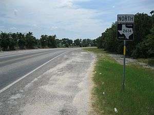 Though marked "North", FM 2614 initially goes southwest from the junction with FM 102 at Bonus.
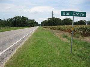 The small community of Elm Grove is near the midpoint of FM 2614. The view is to the west-northwest.
FM 2614 was originally designated on November 24, 1959, to start on FM 950 about 3.5 miles (5.6 km) northeast of Garwood and run south and east to FM 102 at Bonus. The initial authorization is still in effect.
- Junction list
| County | Location | mi[29] | km | Destinations | Notes |
|---|---|---|---|---|---|
| Wharton | Bonus | 0.000 | 0.000 | Southern terminus of FM 2614 | |
| Colorado | Eldridge | 6.597 | 10.617 | Northern terminus of FM 2614 | |
| 1.000 mi = 1.609 km; 1.000 km = 0.621 mi | |||||
FM 2615
| |
|---|---|
| Location | Victoria County |
| Length | 5.761 mi[31] (9.271 km) |
| Existed | 1959[31]–present |
FM 2616
| |
|---|---|
| Location | Lavaca County |
| Length | 6.797 mi[32] (10.939 km) |
| Existed | 1959[32]–present |
FM 2617
| |
|---|---|
| Location | Bee County |
| Length | 1.155 mi[33] (1.859 km) |
| Existed | 1959[33]–present |
RM 2618
| |
|---|---|
| Location | Mason County |
| Length | 7.122 mi[34] (11.462 km) |
| Existed | May 7, 1974[34]–present |
Ranch to Market Road 2618 (RM 2618) is located entirely in Mason County.
RM 2618 begins at an intersection with RM 386 north of Mason. The highway travels in an eastern direction through rural and hilly ranching areas, with state maintenance ending just east of RM 1900; the roadway continues as Fly Gap Road.
RM 2618 was designated in 1974, running from RM 386 eastward at a distance of 2.7 miles (4.3 km). The highway was extended 4.7 miles (7.6 km) eastward in 1976.
- Junction list
The entire route is in Mason County.
| Location | mi[35] | km | Destinations | Notes | |
|---|---|---|---|---|---|
| | 0.0 | 0.0 | |||
| | 6.9 | 11.1 | |||
| | 7.1 | 11.4 | Fly Gap Road | ||
| 1.000 mi = 1.609 km; 1.000 km = 0.621 mi | |||||
FM 2618
Farm to Market Road 2618 (FM 2618) is a designation that has been used twice. No highway currently uses the FM 2618 designation.
FM 2618 (1959)
| |
|---|---|
| Location | Burleson County |
| Existed | November 24, 1959–December 19, 1969 |
The first FM 2618 was designated in 1959, running from FM 111 at Deanville southward to a road intersection at a distance of 3.1 miles (5.0 km). The highway was extended 2.6 miles (4.2 km) southward in 1960. FM 2618 was extended 3.6 miles (5.8 km) north of FM 111 in 1963. The highway was cancelled in 1969, with the mileage being transferred to FM 111.[36]
FM 2618 (1970)
| |
|---|---|
| Location | Bell County |
| Existed | May 7, 1970–January 31, 1974 |
The second FM 2618 was designated in 1970, running from FM 1741 eastward to US 190 at a distance of 5.5 miles (8.9 km). The highway was cancelled and combined with FM 93 in 1974.[37]
FM 2619
| |
|---|---|
| Location | Kleberg County |
| Length | 2.671 mi[38] (4.299 km) |
| Existed | 1959[38]–present |
FM 2620
| |
|---|---|
| Location | Grimes County |
| Length | 11.435 mi[39] (18.403 km) |
| Existed | 1959[39]–present |
FM 2621
| |
|---|---|
| Location | Washington County |
| Length | 6.684 mi[40] (10.757 km) |
| Existed | 1959[40]–present |
FM 2622
| |
|---|---|
| Location | Denton County |
| Length | 1.167 mi[41] (1.878 km) |
| Existed | 1959[41]–present |
Farm to Market Road 2622 (FM 2622) is located entirely in Denton County.
FM 2622 begins at an intersection with Old Stoney Road in Stony. The highway travels in a generally northern direction through residential and farming areas, ending at an intersection with US 380.
FM 2622 was designated in 1959 from SH 24 (now US 380) southward to Stony.
- Junction list
The entire route is in Denton County.
| Location | mi[41] | km | Destinations | Notes | |
|---|---|---|---|---|---|
| | 0.000 | 0.000 | Old Stoney Road | ||
| | 1.167 | 1.878 | |||
| 1.000 mi = 1.609 km; 1.000 km = 0.621 mi | |||||
FM 2623
| |
|---|---|
| Location | Guadalupe County |
| Length | 4.136 mi[42] (6.656 km) |
| Existed | June 28, 1963[42]–present |
Farm to Market Road 2623 (FM 2623) is located entirely in Guadalupe County. The highway connects SH 123 in Geronimo eastward to FM 20.
The current FM 2623 was designated in 1963 from SH 123 eastward to FM 20.
- Junction list
The entire route is in Guadalupe County.
| Location | mi[42] | km | Destinations | Notes | |
|---|---|---|---|---|---|
| Geronimo | 0.000 | 0.000 | |||
| | 4.136 | 6.656 | |||
| 1.000 mi = 1.609 km; 1.000 km = 0.621 mi | |||||
FM 2623 (1959)
| |
|---|---|
| Location | Collin County |
| Existed | November 24, 1959–June 25, 1962 |
The original FM 2623 was designated in 1959, running from FM 544 west of Plano southward to the Dallas County line at a distance of 2.6 miles (4.2 km). The highway was cancelled and removed from the state highway system in 1962.
FM 2624
| |
|---|---|
| Location | Bowie County |
| Length | 5.419 mi[43] (8.721 km) |
| Existed | 1959[43]–present |
FM 2625
| |
|---|---|
| Location | Harrison County |
| Length | 30.71 mi[44] (49.42 km) |
| Existed | 1959[44]–present |
Farm to Market Road 2625 (FM 2625) is located entirely in Harrison County.
FM 2625 begins at an intersection with FM 968 / FM 450 south of Hallsville. The highway travels in a southern / southeastern direction, turning east at a private county road, intersects FM 3251 near the Brady Branch Reservoir, then intersects SH 43 near the Cave Springs Cemetery. FM 2625 continues to run in an eastern direction through forested areas and rural farm land, ending at an intersection with FM 9 southwest of Waskom.
FM 2625 was designated in 1959 from SH 43 near Darco, eastward to US 59 at a distance of 5.8 miles (9.3 km). The highway was extended 6.7 miles (10.8 km) eastward to FM 31 in 1962. FM 2625 was extended 1.5 miles (2.4 km) east of FM 31 to a road intersection in 1970. The highway was extended 1.6 miles (2.6 km) eastward in 1971. FM 2625 was extended 2.7 miles (4.3 km) eastward to a point near Stricklin Springs in 1972. The highway was extended 3.1 miles (5.0 km) eastward to FM 9 in 1973. FM 2625 was extended westward to FM 968 / FM 450 over part of FM 3251 in 1982.[45]
- Junction list
The entire route is in Harrison County.
| Location | mi[46] | km | Destinations | Notes | |
|---|---|---|---|---|---|
| | 0.0 | 0.0 | |||
| | 8.5 | 13.7 | |||
| | 9.9 | 15.9 | |||
| | 15.4 | 24.8 | |||
| | 15.5 | 24.9 | |||
| | 22.0 | 35.4 | |||
| | 30.7 | 49.4 | |||
| 1.000 mi = 1.609 km; 1.000 km = 0.621 mi | |||||
FM 2626
| |
|---|---|
| Location | Newton County |
| Length | 14.097 mi[47] (22.687 km) |
| Existed | 1959[47]–present |
RM 2627
| |
|---|---|
| Location | Brewster County |
| Length | 14.097 mi[48] (22.687 km) |
| Existed | June 28, 1963[48]–present |
Ranch to Market Road 2627 (RM 2627) is a ranch to market road located entirely within Brewster County, Texas.
The southern terminus of RM 2627 is in Brewster County at the currently-closed La Linda International Bridge across the Rio Grande.[49][50] The route travels northwest and traverses Black Gap Wildlife Management area before ending at US 385, 38 miles south of Marathon.[48][51][52]
The current designation for RM 2627 was established in 1963; the route originally ran from US 385 to the southeast 19 miles (31 km). The route was extended to its current terminus the following year.
- Junction list
The entire route is in Brewster County.
| Location | mi[53] | km | Destinations | Notes | |
|---|---|---|---|---|---|
| | 0.0 | 0.0 | La Linda International Bridge | Southern terminus | |
| | 28.0 | 45.1 | Northern terminus | ||
| 1.000 mi = 1.609 km; 1.000 km = 0.621 mi | |||||
FM 2627
| |
|---|---|
| Location | Cass County |
| Existed | November 24, 1959–September 18, 1962 |
Farm to Market Road 2627 (FM 2627) is a former highway that was located in Cass County.
FM 2627 was established in 1959, running from US 59 in Linden eastward to a road intersection near Center Hill in Cass County. The following year, that route was extended further east, to FM 248 in Bivins. FM 2627's mileage was transferred to FM 1841 in 1962.[54]
FM 2628
| |
|---|---|
| Location | Walker County |
| Length | 3.417 mi[55] (5.499 km) |
| Existed | December 14, 1977[55]–present |
FM 2628 (1959)
| |
|---|---|
| Location | Freestone County |
| Existed | November 24, 1959–October 31, 1977 |
FM 2629
| |
|---|---|
| Location | Hidalgo, Cameron and Willacy counties |
| Length | 12.799 mi[56][nb 2] (20.598 km) |
| Existed | 1959[56]–present |
Farm to Market Road 2629 (FM 2629) is located in Hidalgo, Cameron and Willacy counties in the Lower Rio Grande Valley.
FM 2629 begins at an intersection with FM 491 northeast of La Villa. The highway travels in an eastern direction, intersecting FM 1425 on the Hidalgo-Cameron county line. FM 2629 intersects FM 2845 south of Zapata Ranch, then has an overlap with FM 506 and Spur 413 through the town of Sebastian. The highway turns south just east of I-69E / US 77, then turns back east at County Line Road, running along the Cameron-Willacy county line, ending at an intersection with FM 507.
FM 2629 was designated in 1959 from FM 491 eastward to the Cameron County line, then eastward near and along the Cameron/Willacy County line to FM 506 at a distance of 4.9 miles (7.9 km). The highway was extended 8.2 miles (13.2 km) eastward to FM 507 in 1966.
- Junction list
| County | Location | mi[57] | km | Destinations | Notes |
|---|---|---|---|---|---|
| Hidalgo | | 0.0 | 0.0 | ||
| Hidalgo–Cameron county line | | 2.1 | 3.4 | ||
| Willacy–Cameron county line | | 4.2 | 6.8 | ||
| Willacy | Sebastian | 4.8 | 7.7 | West end of FM 506 overlap | |
| 5.3 | 8.5 | ||||
| 6.7 | 10.8 | East end of FM 506 overlap; west end of Spur 413 overlap | |||
| 7.0 | 11.3 | I-69E exit 38; east end of Spur 413 overlap | |||
| Willacy–Cameron county line | | 14.9 | 24.0 | ||
1.000 mi = 1.609 km; 1.000 km = 0.621 mi
| |||||
RM 2630
| |
|---|---|
| Location | Edwards County |
| Length | 4.992 mi[58] (8.034 km) |
| Existed | 1959[58]–present |
RM 2631
| |
|---|---|
| Location | Real County |
| Length | 8.542 mi[59] (13.747 km) |
| Existed | 1959[59]–present |
FM 2632
| |
|---|---|
| Location | Brown County |
| Length | 5.727 mi[60] (9.217 km) |
| Existed | 1959[60]–present |
FM 2633
| |
|---|---|
| Location | Coleman County |
| Length | 13.505 mi[61] (21.734 km) |
| Existed | 1959[61]–present |
FM 2634
| |
|---|---|
| Location | Montague County |
| Length | 3.707 mi[62] (5.966 km) |
| Existed | January 31, 1961[62]–present |
Farm to Market Road 2634 or FM 2634 is a two-lane, state-maintained highway that connects Lake Nocona, Texas with Farm to Market Road 103 and, indirectly, Nocona, Texas and southern Oklahoma. FM 2634 intersects with FM 103 leading to Spanish Fort and Nocona and Farm to Market Road 2953 leading to FM 677 and southern Oklahoma and Saint Jo, Texas, as well as other various county secondary roads.
FM 2634 begins at an intersection with FM 103 in Montague County, heading east on a two-lane undivided road. The road heads through open farmland with some trees and homes, intersecting the northern terminus of FM 3428. The highway intersects the western terminus of FM 2953 and heads southeast through woods. FM 2634 curves east into residential areas and ends at Weldon Robb Park on Lake Nocona.[63][64]
Paved after the development of Lake Nocona in 1960, the current FM 2634 was designated onto its current alignment in 1961 and connects the lake with Nocona and smaller communities in north central Montague County. Nocona became the economic hub of northern Montague County by the turn of the 20th Century, and Lake Nocona or "Farmer's Creek Reservoir' was developed in 1959-60 to supply the city of Nocona with water. FM 2634 connects the various housing developments and recreational areas around the lake with Nocona.
- Junction list
The entire route is in Lake Nocona, Montague County.
| mi[63] | km | Destinations | Notes | ||
|---|---|---|---|---|---|
| 0.0 | 0.0 | ||||
| 2.0 | 3.2 | Northern terminus of FM 3428 | |||
| 2.8 | 4.5 | Western terminus of FM 2953 | |||
| 3.7 | 6.0 | Weldon Robb Park | |||
| 1.000 mi = 1.609 km; 1.000 km = 0.621 mi | |||||
FM 2634 (1959)
| |
|---|---|
| Location | Comanche County |
| Existed | November 25, 1959–October 14, 1960 |
FM 2634 was first designated in 1959 for a road in Comanche County running from SH 36 in Comanche northeast 5.7 miles (9.2 km). In 1960, the FM 2634 designation on this road was replaced with FM 1689.[65]
FM 2635
| |
|---|---|
| Location | McCulloch County |
| Length | 5.472 mi[66] (8.806 km) |
| Existed | 1959[66]–present |
FM 2636
| |
|---|---|
| Location | Henderson County |
| Length | 3.082 mi[67] (4.960 km) |
| Existed | October 30, 1961[67]–present |
FM 2636 (1959)
| |
|---|---|
| Location | Hudspeth County |
| Existed | November 24, 1959–October 17, 1960 |
FM 2637
| |
|---|---|
| Location | El Paso County |
| Length | 0.728 mi[68] (1.172 km) |
| Existed | 1959[68]–present |
Farm to Market Road 2637 (FM 2637) is a short highway located entirely in El Paso County in the city of El Paso.
FM 2637 begins at an intersection with FM 2529 (McCombs Street) in the northern part of the city. The highway travels in an eastern direction through rural areas of the city, with the roadway ending at a dead end near a pump station for the El Paso Natural Gas Company.
FM 2637 was designated in 1959 along its current route.
- Junction list
The entire route is in El Paso, El Paso County.
| mi[68] | km | Destinations | Notes | ||
|---|---|---|---|---|---|
| 0.000 | 0.000 | ||||
| 0.728 | 1.172 | Road dead ends | |||
| 1.000 mi = 1.609 km; 1.000 km = 0.621 mi | |||||
FM 2638
| |
|---|---|
| Location | Childress County |
| Length | 4.676 mi[69] (7.525 km) |
| Existed | 1959[69]–present |
FM 2639
| |
|---|---|
| Location | Hall County |
| Length | 3.378 mi[70] (5.436 km) |
| Existed | 1959[70]–present |
FM 2640
| |
|---|---|
| Location | Hardeman County |
| Length | 3.25 mi[71] (5.23 km) |
| Existed | 1959[71]–present |
FM 2641
| |
|---|---|
| Location | Hockley and Lubbock counties |
| Length | 20.79 mi[72] (33.46 km) |
| Existed | September 20, 1961[72]–present |
Farm to Market Road 2641 (FM 2641) is a farm-to-market road located in the greater Lubbock area of the US state of Texas. The highway is known locally in Lubbock as Regis Street.
FM 2641 begins at an intersection with FM 2130 south of Roundup. The highway travels east before intersecting FM 2378 and crossing into Lubbock County. FM 2641 continues traveling east and intersects with FM 179 and U.S. Highway 84 (US 84) near Shallowater. The highway has an intersection with FM 2525 (N. Frankford Avenue) and FM 1264 (N. University Avenue) before entering the city limits of Lubbock. FM 2641 crosses Interstate 27 (I-27) and US 87 and runs just south of Lubbock Preston Smith International Airport before leaving the city limits. The highway ends at an intersection with US 62/US 84 and State Highway 114 (SH 114) just east of the city.[73][74]
The current FM 2641 was designated in 1961, running from FM 2130 to US 84. The highway was further extended east in 1968 to US 87 (later I-27) and later to US 62/US 82/SH 114 (Idalou Road) in 1973. In 1995, the section of FM 2641 from FM 1264 to Idalou Road was internally designated by Texas Department of Transportation (TxDOT) as Urban Road 2641.[75]
- Junction list
| County | Location | mi[74] | km | Destinations | Notes |
|---|---|---|---|---|---|
| Hockley | | 0.0 | 0.0 | ||
| | 1.5 | 2.4 | |||
| Lubbock | | 5.5 | 8.9 | ||
| | 9.0 | 14.5 | |||
| | 9.5 | 15.3 | |||
| | 13.5 | 21.7 | |||
| Lubbock | 15.6 | 25.1 | I-27 exit 8 | ||
| | 20.8 | 33.5 | |||
| 1.000 mi = 1.609 km; 1.000 km = 0.621 mi | |||||
FM 2641 (1959)
| |
|---|---|
| Location | Motley County |
| Existed | November 24, 1959–October 18, 1960 |
The original FM 2641 was designated in 1959, running from FM 94 at Northfield northwestward at a distance of 3.0 miles (4.8 km). The highway was cancelled in 1960, with the mileage being transferred to FM 656.[76]
FM 2642
| |
|---|---|
| Location | Hunt County |
| Length | 2.593 mi[77] (4.173 km) |
| Existed | 1959[77]–present |
FM 2643
| |
|---|---|
| Location | McLennan and Falls counties |
| Length | 10.781 mi[78] (17.350 km) |
| Existed | 1959[78]–present |
FM 2644
| |
|---|---|
| Location | Dimmit and Maverick counties |
| Length | 27.159 mi[79] (43.708 km) |
| Existed | 1960[79]–present |
FM 2645
| |
|---|---|
| Location | Fannin County |
| Length | 5.07 mi[80] (8.16 km) |
| Existed | 1960[80]–present |
FM 2646
| |
|---|---|
| Location | Hockley County |
| Length | 12.708 mi[81] (20.452 km) |
| Existed | 1960[81]–present |
Farm to Market Road 2646 (FM 2646) is located entirely in Hockley County.
FM 2646 begins at an intersection with FM 1585. The highway travels in a northern direction through rural areas, intersecting SH 114 between Opdyke West and Smyer. FM 2646 continues to travel through rural areas, ending at an intersection with FM 1294.
FM 2646 was designated in 1960, running from SH 116 (now SH 114) southward to FM 1585 at a distance of 7.0 miles (11.3 km). The highway was extended 5.8 miles (9.3 km) northward from SH 116 to FM 1294 in 1963.
- Junction list
The entire route is in Hockley County.
| Location | mi[82] | km | Destinations | Notes | |
|---|---|---|---|---|---|
| | 0.0 | 0.0 | |||
| | 6.9 | 11.1 | |||
| | 12.7 | 20.4 | |||
| 1.000 mi = 1.609 km; 1.000 km = 0.621 mi | |||||
FM 2647
| |
|---|---|
| Location | Runnels County |
| Length | 12.821 mi[83] (20.633 km) |
| Existed | 1960[83]–present |
FM 2648
| |
|---|---|
| Location | Lamar County |
| Length | 8.821 mi[84] (14.196 km) |
| Existed | 1960[84]–present |
FM 2649
| |
|---|---|
| Location | Hunt County |
| Length | 8.402 mi[85] (13.522 km) |
| Existed | June 28, 1963[85]–present |
Farm to Market Road 2649 (FM 2649) is located entirely in Hunt County.
FM 2649 begins at an intersection with FM 1567. The highway travels in a northern direction through rural farming areas, ending at an intersection with the eastbound frontage road of I-30 between Campbell and Cumby.
The current FM 2649 was designated in 1963 from FM 1567 northward to I-30.
- Junction list
The entire route is in Hunt County.
| Location | mi[85] | km | Destinations | Notes | |
|---|---|---|---|---|---|
| | 0.000 | 0.000 | |||
| | 8.402 | 13.522 | I-30 exit 104 / 110 | ||
| 1.000 mi = 1.609 km; 1.000 km = 0.621 mi | |||||
FM 2649 (1960)
| |
|---|---|
| Location | Cooke County |
| Existed | September 27, 1960–May 25, 1962 |
The original FM 2649 was designated in 1960, running from FM 1630 south of Myra, southward to a road intersection at a distance of 2.8 miles (4.5 km). The highway was cancelled in 1962, with the mileage being transferred to FM 1198.[86]
FM 2650
| |
|---|---|
| Location | Archer and Wichita counties |
| Length | 4.32 mi[87][nb 3] (6.95 km) |
| Existed | 1960[87]–present |
Farm to Market Road 2650 (FM 2650) is located in Archer and Wichita counties.
FM 2650 begins at an intersection with FM 1954. The highway travels in a northern direction through a semi-suburban area and crosses over Lake Wichita. FM 2650 enters Wichita Falls in the Allendale area, has an overlap with FM 368, then ends at a junction with US 82 / US 277 / Bus. US 277. The section of highway south of FM 369 is known locally as Sisk Road, while north of FM 369 it is known as Allendale Road.
FM 2650 was designated in 1960, running from FM 368 southward to FM 1954 at a distance of 3.6 miles (5.8 km). The highway was extended 0.8 miles (1.3 km) northward from FM 368 to US 82 in 1974. In 1995, the section of FM 2650 between FM 368 and US 82 was internally re-designated as Urban Road 2650 by TxDOT.[88]
- Junction list
| County | Location | mi[89] | km | Destinations | Notes |
|---|---|---|---|---|---|
| Archer | | 0.0 | 0.0 | ||
| Wichita | Wichita Falls | 3.5 | 5.6 | South end of FM 369 overlap | |
| 4.0 | 6.4 | North end of FM 369 overlap | |||
| 4.8 | 7.7 | Interchange | |||
1.000 mi = 1.609 km; 1.000 km = 0.621 mi
| |||||
FM 2651
| |
|---|---|
| Location | Throckmorton County |
| Length | 3.747 mi[90] (6.030 km) |
| Existed | 1960[90]–present |
FM 2652
| |
|---|---|
| Location | Young County |
| Length | 15.528 mi[91] (24.990 km) |
| Existed | 1960[91]–present |
FM 2653
| |
|---|---|
| Location | Hopkins County |
| Length | 18.252 mi[92][nb 4] (29.374 km) |
| Existed | 1960[92]–present |
Farm to Market Road 2653 (FM 2653) is located entirely in Hopkins County.
FM 2653 begins at an intersection with FM 275 north of Miller Grove. The highway travels in an eastern direction, turning north at County Road 1152, then briefly runs in a northeastern direction at County Road 1127. FM 2653 continues to alternate between running in an eastern and northern direction until reaching Brasher, having a short overlap with US 67 through the town, then having a junction with I-30 just outside of the town. The highway turns northwest at County Road 4715, turning back north near SH 11. FM 2653 continues to travel in a northern direction through rural farming areas, ending at an intersection with FM 71.
FM 2653 was designated in 1960, traveling from FM 71 southward to US 67 at Brashear at a distance of 10.0 miles (16.1 km). The highway was extended 8.0 miles (12.9 km) south of US 67 to FM 275 in 1962.
- Junction list
The entire route is in Hopkins County.
| Location | mi[93] | km | Destinations | Notes | |
|---|---|---|---|---|---|
| | 0.0 | 0.0 | |||
| Brashear | 8.7 | 14.0 | South end of US 67 overlap | ||
| 9.0 | 14.5 | North end of US 67 overlap | |||
| | 9.3 | 15.0 | I-30 exit 116 | ||
| | 14.3 | 23.0 | |||
| | 18.6 | 29.9 | |||
1.000 mi = 1.609 km; 1.000 km = 0.621 mi
| |||||
RM 2654
| |
|---|---|
| Location | Hemphill County |
| Length | 8.262 mi[94] (13.296 km) |
| Existed | 1960[94]–present |
FM 2655
| |
|---|---|
| Location | Hunt County |
| Length | 3.901 mi[95] (6.278 km) |
| Existed | May 6, 1964[95]–present |
RM 2655
| |
|---|---|
| Location | Hutchinson County |
| Existed | September 27, 1960–March 10, 1964 |
Ranch to Market Road 2655 (RM 2655) is a former highway that was located in Hutchinson County.
RM 2655 was designated in 1960, traveling from SH 152 near Stinnett southward at a distance of 3.5 miles (5.6 km). The highway was cancelled in 1964, with the mileage being transferred to RM 687.[96]
FM 2656
| |
|---|---|
| Location | DeWitt County |
| Length | 6.741 mi[97] (10.849 km) |
| Existed | 1960[97]–present |
FM 2657
| |
|---|---|
| Location | Burnet and Lampasas counties |
| Length | 16.908 mi[98] (27.211 km) |
| Existed | May 5, 1992[98]–present |
Farm to Market Road 2657 (FM 2657) is a farm to market road in Burnet and Lampasas counties, Texas.
FM 2657 begins in Briggs at an intersection with Loop 308, the old alignment of US 183 through the community.[99][100] The route runs briefly to the northeast and then to the north through unincorporated Burnet County. It has an intersection with RM 963 before entering southern Lampasas County.[101] FM 2657 ends at an intersection with US 190 in Copperas Cove, just west of the Coryell County line.
FM 2657 was designated in 1992 when the second RM 2657 was re-designated as a farm to market road.
- Junction list
| County | Location | mi[102] | km | Destinations | Notes |
|---|---|---|---|---|---|
| Burnet | Briggs | 0.0 | 0.0 | Southern terminus | |
| | 8.3 | 13.4 | |||
| Lampasas | | 15.1 | 24.3 | ||
| | 15.6 | 25.1 | |||
| Copperas Cove | 16.9 | 27.2 | Northern terminus | ||
| 1.000 mi = 1.609 km; 1.000 km = 0.621 mi | |||||
RM 2657
Ranch to Market Road 2657 (RM 2657) is a designation that has been used twice. No highway currently uses the RM 2657 designation.
RM 2657 (1960)
| |
|---|---|
| Location | Gregg and Harrison counties |
| Existed | September 27, 1960–October 17, 1966 |
The first RM 2657 was designated in Gregg County in 1960, from SH 26 (now US 259) to the Harrison County line. In 1962, the route was extended east to FM 2208 in Harrison County. In 1966, that route became part of FM 449.[103]
RM 2657 (1967)
| |
|---|---|
| Location | Burnet and Lampasas counties |
| Existed | June 2, 1967–May 5, 1992 |
The second RM 2657 became part of the state highway system in 1967, replacing the southern section of RM 963 to Briggs and the northern section of FM 2808 to Copperas Cove.[104][105] The highway was re-designated as FM 2657 in 1992.
FM 2658
| |
|---|---|
| Location | Rusk County |
| Length | 6.539 mi[106] (10.524 km) |
| Existed | 1960[106]–present |
FM 2659
| |
|---|---|
| Location | Wood County |
| Length | 6.296 mi[107] (10.132 km) |
| Existed | 1960[107]–present |
FM 2660
| |
|---|---|
| Location | Jones County |
| Length | 4.477 mi[108] (7.205 km) |
| Existed | 1960[108]–present |
FM 2661
| |
|---|---|
| Location | Smith County |
| Length | 12.996 mi[109] (20.915 km) |
| Existed | 1960[108]'–present |
FM 2662
| |
|---|---|
| Location | Coke County |
| Length | 9.45 mi[110] (15.21 km) |
| Existed | June 1, 1965[110]–present |
FM 2662 (1960)
| |
|---|---|
| Location | Angelina County |
| Existed | September 27, 1960–October 14, 1964 |
FM 2663
| |
|---|---|
| Location | Houston County |
| Length | 4.409 mi[111] (7.096 km) |
| Existed | 1960[111]–present |
FM 2664
| |
|---|---|
| Location | Nacogdoches County |
| Length | 2.248 mi[112] (3.618 km) |
| Existed | 1960[112]–present |
FM 2665
| |
|---|---|
| Location | Polk County |
| Length | 8.368 mi[113] (13.467 km) |
| Existed | 1960[113]–present |
FM 2666
| |
|---|---|
| Location | San Jacinto County |
| Length | 7.253 mi[114] (11.673 km) |
| Existed | 1960[114]–present |
FM 2667
| |
|---|---|
| Location | Shelby County |
| Length | 3.348 mi[115] (5.388 km) |
| Existed | 1960[115]–present |
FM 2668
| |
|---|---|
| Location | Matagorda County |
| Length | 13.772 mi[116] (22.164 km) |
| Existed | 1960[116]–present |
FM 2669
| |
|---|---|
| Location | Shelby County |
| Length | 1.483 mi[117] (2.387 km) |
| Existed | 1960[117]–present |
FM 2670
| |
|---|---|
| Location | Bell County |
| Length | 3.887 mi[118] (6.256 km) |
| Existed | 1960[118]–present |
FM 2671
| |
|---|---|
| Location | McLennan and Coryell counties |
| Length | 6.908 mi[119] (11.117 km) |
| Existed | 1960[119]–present |
FM 2672
| |
|---|---|
| Location | Fayette County |
| Length | 5.336 mi[120] (8.587 km) |
| Existed | 1960[120]–present |
FM 2673
| |
|---|---|
| Location | Comal County |
| Length | 10.019 mi[121] (16.124 km) |
| Existed | 1960[121]–present |
FM 2674
| |
|---|---|
| Location | Wharton County |
| Length | 6.014 mi[122] (9.679 km) |
| Existed | 1960[122]–present |
FM 2675
| |
|---|---|
| Location | Lamar and Delta counties |
| Length | 6.852 mi[123] (11.027 km) |
| Existed | June 28, 1963[123]–present |
FM 2675 (1960)
| |
|---|---|
| Location | Guadalupe and Comal counties |
| Existed | September 27, 1960–May 28, 1961 |
FM 2676
| |
|---|---|
| Location | Medina County |
| Length | 17.662 mi[124] (28.424 km) |
| Existed | 1960[124]–present |
FM 2677
| |
|---|---|
| Location | Sherman County |
| Length | 11.187 mi[125] (18.004 km) |
| Existed | May 2, 1962[125]–present |
FM 2677 (1960)
| |
|---|---|
| Location | Grimes County |
| Existed | September 27, 1960–October 31, 1961 |
FM 2678
| |
|---|---|
| Location | Refugio County |
| Length | 9.571 mi[126] (15.403 km) |
| Existed | 1960[126]–present |
FM 2679
| |
|---|---|
| Location | Washington County |
| Length | 5.242 mi[127] (8.436 km) |
| Existed | 1960[127]–present |
FM 2680
| |
|---|---|
| Location | Angelina County |
| Length | 1.161 mi[128] (1.868 km) |
| Existed | January 26, 1962[128]–present |
FM 2680 (1960)
| |
|---|---|
| Location | Camp County |
| Existed | September 27, 1960–October 9, 1961 |
FM 2681
| |
|---|---|
| Location | Limestone County |
| Length | 1.324 mi[129] (2.131 km) |
| Existed | December 13, 1962[129]–present |
FM 2681 (1960)
| |
|---|---|
| Location | Titus County |
| Existed | September 27, 1960–May 25, 1962 |
FM 2682
| |
|---|---|
| Location | Harrison County |
| Length | 2.802 mi[130] (4.509 km) |
| Existed | 1960[130]–present |
FM 2683
| |
|---|---|
| Location | Cass and Marion County |
| Length | 11.094 mi[131] (17.854 km) |
| Existed | 1960[131]–present |
FM 2684
| |
|---|---|
| Location | Liberty County |
| Length | 2.081 mi[132] (3.349 km) |
| Existed | 1960[132]–present |
FM 2685
| |
|---|---|
| Location | Upshur County |
| Length | 10.614 mi[133] (17.082 km) |
| Existed | 1960[133]–present |
FM 2686
| |
|---|---|
| Location | Starr County |
| Length | 18.114 mi[134] (29.152 km) |
| Existed | 1960[134]–present |
FM 2687
| |
|---|---|
| Location | Zapata and Jim Hogg counties |
| Length | 18.139 mi[135] (29.192 km) |
| Existed | 1960[135]–present |
FM 2688
| |
|---|---|
| Location | Dimmit County |
| Length | 13.122 mi[136] (21.118 km) |
| Existed | 1960[136]–present |
FM 2689
| |
|---|---|
| Location | Eastland County |
| Length | 7.805 mi[137] (12.561 km) |
| Existed | 1960[137]–present |
RM 2690
| |
|---|---|
| Location | Uvalde County |
| Length | 11.421 mi[138] (18.380 km) |
| Existed | 1960[138]–present |
FM 2691
| |
|---|---|
| Location | Zavala County |
| Length | 8.591 mi[139] (13.826 km) |
| Existed | 1960[139]–present |
RM 2692
| |
|---|---|
| Location | Palo Pinto County |
| Length | 8.047 mi[140] (12.950 km) |
| Existed | August 27, 1963[140]–present |
FM 2692
| |
|---|---|
| Location | Comanche County |
| Existed | October 26, 1961–May 24, 1962 |
FM 2693
| |
|---|---|
| Location | San Jacinto and Walker counties |
| Length | 10.521 mi[141] (16.932 km) |
| Existed | 1960[141]–present |
FM 2694
| |
|---|---|
| Location | Shelby County |
| Length | 13.304 mi[142] (21.411 km) |
| Existed | 1960[142]–present |
FM 2695
| |
|---|---|
| Location | Shelby County |
| Length | 0.455 mi[143] (0.732 km) |
| Existed | October 29, 1992[143]–present |
RM 2695
| |
|---|---|
| Location | Gray and Donley counties |
| Existed | February 22, 1961–August 29, 1990[144] |
FM 2696
| |
|---|---|
| Location | Bexar County |
| Length | 16.028 mi[145] (25.795 km) |
| Existed | 1961[145]–present |
FM 2697
| |
|---|---|
| Location | Wheeler County |
| Length | 4.036 mi[146] (6.495 km) |
| Existed | 1961[146]–present |
FM 2698
| |
|---|---|
| Location | Swisher County |
| Length | 4.352 mi[147] (7.004 km) |
| Existed | 1961[147]–present |
Farm to Market Road 2698 (FM 2698) is located entirely in Swisher County.
FM 2698 begins at a junction with I-27 / US 87 in a rural part of the county. The highway travels in an eastern direction through rural, unincorporated areas of the county, passes the Wrangler Feedyards, ending at an intersection with FM 146 north of Tulia.
FM 2698 was designated in 1961 along the current route.
- Junction list
The entire route is in Swisher County.
| Location | mi[147] | km | Destinations | Notes | |
|---|---|---|---|---|---|
| | 0.000 | 0.000 | I-27 exit 83 | ||
| | 4.352 | 7.004 | |||
| 1.000 mi = 1.609 km; 1.000 km = 0.621 mi | |||||
RM 2699
| |
|---|---|
| Location | Roberts County |
| Length | 7.223 mi[148] (11.624 km) |
| Existed | 1961[148]–present |
Notes
- ↑ The certified length given is shorter than the actual mileage, as the Texas Department of Transportation description of FM 2609 considers it to be discontinuous at rather than concurrent with FM 941.
- ↑ The certified length given is shorter than the actual mileage, as the Texas Department of Transportation description of FM 2629 considers it to be discontinuous at rather than concurrent with FM 506 and Spur 413.
- ↑ The certified length given is shorter than the actual mileage, as the Texas Department of Transportation description of FM 2650 considers it to be discontinuous at rather than concurrent with FM 369.
- ↑ The certified length given is shorter than the actual mileage, as the Texas Department of Transportation description of FM 2653 considers it to be discontinuous at rather than concurrent with US 67.
References
- 1 2 Transportation Planning and Programming Division (n.d.). "Ranch to Market Road No. 2600". Highway Designation Files. Texas Department of Transportation. Retrieved July 6, 2018.
- ↑ Transportation Planning and Programming Division (n.d.). "Farm to Market Road No. 1170". Highway Designation Files. Texas Department of Transportation. Retrieved July 6, 2018.
- 1 2 Transportation Planning and Programming Division (n.d.). "Farm to Market Road No. 2601". Highway Designation Files. Texas Department of Transportation. Retrieved July 6, 2018.
- ↑ Google (July 6, 2018). "Route of FM 2601" (Map). Google Maps. Google. Retrieved July 6, 2018.
- 1 2 Transportation Planning and Programming Division (n.d.). "Farm to Market Road No. 2602". Highway Designation Files. Texas Department of Transportation. Retrieved July 6, 2018.
- 1 2 Transportation Planning and Programming Division (n.d.). "Farm to Market Road No. 2603". Highway Designation Files. Texas Department of Transportation. Retrieved July 6, 2018.
- 1 2 Transportation Planning and Programming Division (n.d.). "Farm to Market Road No. 2604". Highway Designation Files. Texas Department of Transportation. Retrieved July 6, 2018.
- 1 2 3 Transportation Planning and Programming Division (n.d.). "Farm to Market Road No. 2605". Highway Designation Files. Texas Department of Transportation. Retrieved July 6, 2018.
- ↑ Transportation Planning and Programming Division (n.d.). "Urban Road No. 2605". Highway Designation Files. Texas Department of Transportation. Retrieved July 6, 2018.
- 1 2 Transportation Planning and Programming Division (n.d.). "Farm to Market Road No. 2606". Highway Designation Files. Texas Department of Transportation. Retrieved July 6, 2018.
- ↑ Transportation Planning and Programming Division (2012). Texas County Mapbook (PDF) (Map) (2012 ed.). 1:120,000. Texas Department of Transportation. p. 388. OCLC 867856197. Retrieved 2011-01-10.
- ↑ Google (2011-01-10). "Overview map of Farm to Market Road 2606 Distances Between Interchanges" (Map). Google Maps. Google. Retrieved 2011-01-10.
- ↑ Transportation Planning and Programming Division (n.d.). "Farm to Market Road No. 2011". Highway Designation Files. Texas Department of Transportation. Retrieved July 6, 2018.
- ↑ Transportation Planning and Programming Division (n.d.). "Farm to Market Road No. 971". Highway Designation Files. Texas Department of Transportation. Retrieved July 6, 2018.
- 1 2 Transportation Planning and Programming Division (n.d.). "Farm to Market Road No. 2607". Highway Designation Files. Texas Department of Transportation. Retrieved July 6, 2018.
- 1 2 Transportation Planning and Programming Division (n.d.). "Farm to Market Road No. 2608". Highway Designation Files. Texas Department of Transportation. Retrieved July 6, 2018.
- 1 2 Transportation Planning and Programming Division (n.d.). "Farm to Market Road No. 2609". Highway Designation Files. Texas Department of Transportation. Retrieved July 6, 2018.
- ↑ Google (July 22, 2018). "Route of FM 2609" (Map). Google Maps. Google. Retrieved July 22, 2018.
- 1 2 Transportation Planning and Programming Division (n.d.). "Farm to Market Road No. 2610". Highway Designation Files. Texas Department of Transportation. Retrieved July 6, 2018.
- 1 2 Transportation Planning and Programming Division (n.d.). "Farm to Market Road No. 2611". Highway Designation Files. Texas Department of Transportation. Retrieved July 6, 2018.
- ↑ Transportation Planning and Programming Division (n.d.). "Farm to Market Road No. 2541". Highway Designation Files. Texas Department of Transportation. Retrieved July 6, 2018.
- ↑ Google (July 6, 2018). "Route of FM 2611" (Map). Google Maps. Google. Retrieved July 6, 2018.
- 1 2 Transportation Planning and Programming Division (n.d.). "Farm to Market Road No. 2612". Highway Designation Files. Texas Department of Transportation. Retrieved July 6, 2018.
- ↑ Google (July 6, 2018). "Route of FM 2612" (Map). Google Maps. Google. Retrieved July 6, 2018.
- ↑ Transportation Planning and Programming Division (n.d.). "State Highway Loop No. 108". Highway Designation Files. Texas Department of Transportation. Retrieved July 6, 2018.
- 1 2 Transportation Planning and Programming Division (n.d.). "Farm to Market Road No. 2613". Highway Designation Files. Texas Department of Transportation. Retrieved July 6, 2018.
- ↑ (PDF) https://publicdocs.txdot.gov/minord/MinuteOrderDocLib/003676533.pdf. Missing or empty
|title=(help) - ↑ (PDF) https://publicdocs.txdot.gov/minord/MinuteOrderDocLib/003676559.pdf. Missing or empty
|title=(help) - 1 2 3 Transportation Planning and Programming Division (n.d.). "Farm to Market Road No. 2614". Highway Designation Files. Texas Department of Transportation. Retrieved July 6, 2018.
- ↑ Google (July 13, 2013). "Route of FM 2614" (Map). Google Maps. Google. Retrieved July 13, 2013.
- 1 2 Transportation Planning and Programming Division (n.d.). "Farm to Market Road No. 2615". Highway Designation Files. Texas Department of Transportation. Retrieved July 6, 2018.
- 1 2 Transportation Planning and Programming Division (n.d.). "Farm to Market Road No. 2616". Highway Designation Files. Texas Department of Transportation. Retrieved July 6, 2018.
- 1 2 Transportation Planning and Programming Division (n.d.). "Farm to Market Road No. 2617". Highway Designation Files. Texas Department of Transportation. Retrieved July 6, 2018.
- 1 2 Transportation Planning and Programming Division (n.d.). "Ranch to Market Road No. 2618". Highway Designation Files. Texas Department of Transportation. Retrieved July 6, 2018.
- ↑ Google (July 6, 2018). "Route of RM 2618" (Map). Google Maps. Google. Retrieved July 6, 2018.
- ↑ Transportation Planning and Programming Division (n.d.). "Farm to Market Road No. 111". Highway Designation Files. Texas Department of Transportation. Retrieved July 6, 2018.
- ↑ Transportation Planning and Programming Division (n.d.). "Farm to Market Road No. 93". Highway Designation Files. Texas Department of Transportation. Retrieved July 6, 2018.
- 1 2 Transportation Planning and Programming Division (n.d.). "Farm to Market Road No. 2619". Highway Designation Files. Texas Department of Transportation. Retrieved July 6, 2018.
- 1 2 Transportation Planning and Programming Division (n.d.). "Farm to Market Road No. 2620". Highway Designation Files. Texas Department of Transportation. Retrieved July 6, 2018.
- 1 2 Transportation Planning and Programming Division (n.d.). "Farm to Market Road No. 2621". Highway Designation Files. Texas Department of Transportation. Retrieved July 6, 2018.
- 1 2 3 Transportation Planning and Programming Division (n.d.). "Farm to Market Road No. 2622". Highway Designation Files. Texas Department of Transportation. Retrieved July 6, 2018.
- 1 2 3 Transportation Planning and Programming Division (n.d.). "Farm to Market Road No. 2623". Highway Designation Files. Texas Department of Transportation. Retrieved July 6, 2018.
- 1 2 Transportation Planning and Programming Division (n.d.). "Farm to Market Road No. 2624". Highway Designation Files. Texas Department of Transportation. Retrieved July 6, 2018.
- 1 2 Transportation Planning and Programming Division (n.d.). "Farm to Market Road No. 2625". Highway Designation Files. Texas Department of Transportation. Retrieved July 6, 2018.
- ↑ Transportation Planning and Programming Division (n.d.). "Farm to Market Road No. 3251". Highway Designation Files. Texas Department of Transportation. Retrieved July 6, 2018.
- ↑ Google (July 6, 2018). "Route of FM 2625" (Map). Google Maps. Google. Retrieved July 6, 2018.
- 1 2 Transportation Planning and Programming Division (n.d.). "Farm to Market Road No. 2626". Highway Designation Files. Texas Department of Transportation. Retrieved July 6, 2018.
- 1 2 3 Transportation Planning and Programming Division (n.d.). "Ranch to Market Road No. 2627". Highway Designation Files. Texas Department of Transportation. Retrieved July 6, 2018.
- ↑ Transportation Planning and Programming Division (2014). Texas County Mapbook (PDF) (Map) (2014 ed.). 1:120,000. Texas Department of Transportation. p. 86. Retrieved April 6, 2015.
- ↑ "Texas–Mexico International Bridges and Border Crossings" (PDF). Texas Department of Transportation. 2013. pp. 80–81. Archived from the original (PDF) on February 3, 2014. Retrieved April 6, 2015.
- ↑ Transportation Planning and Programming Division (2014). Texas County Mapbook (PDF) (Map) (2014 ed.). 1:120,000. Texas Department of Transportation. p. 85. Retrieved April 6, 2015.
- ↑ Transportation Planning and Programming Division (2014). Texas County Mapbook (PDF) (Map) (2014 ed.). 1:120,000. Texas Department of Transportation. p. 56. Retrieved April 6, 2015.
- ↑ Google (September 21, 2011). "Overview map of Ranch to Market Road 2627 Distances Between Interchanges" (Map). Google Maps. Google. Retrieved September 21, 2011.
- ↑ Transportation Planning and Programming Division (n.d.). "Farm to Market Road No. 1841". Highway Designation Files. Texas Department of Transportation. Retrieved July 6, 2018.
- 1 2 Transportation Planning and Programming Division (n.d.). "Farm to Market Road No. 2628". Highway Designation Files. Texas Department of Transportation. Retrieved July 6, 2018.
- 1 2 Transportation Planning and Programming Division (n.d.). "Farm to Market Road No. 2629". Highway Designation Files. Texas Department of Transportation. Retrieved July 6, 2018.
- ↑ Google (July 6, 2018). "Route of FM 2629" (Map). Google Maps. Google. Retrieved July 6, 2018.
- 1 2 Transportation Planning and Programming Division (n.d.). "Ranch to Market Road No. 2630". Highway Designation Files. Texas Department of Transportation. Retrieved July 6, 2018.
- 1 2 Transportation Planning and Programming Division (n.d.). "Ranch to Market Road No. 2631". Highway Designation Files. Texas Department of Transportation. Retrieved July 6, 2018.
- 1 2 Transportation Planning and Programming Division (n.d.). "Farm to Market Road No. 2632". Highway Designation Files. Texas Department of Transportation. Retrieved July 6, 2018.
- 1 2 Transportation Planning and Programming Division (n.d.). "Farm to Market Road No. 2633". Highway Designation Files. Texas Department of Transportation. Retrieved July 6, 2018.
- 1 2 Transportation Planning and Programming Division (n.d.). "Farm to Market Road No. 2634". Highway Designation Files. Texas Department of Transportation. Retrieved July 6, 2018.
- 1 2 Google (February 1, 2013). "List of Farm to Market Roads in Texas (2600–2699)" (Map). Google Maps. Google. Retrieved February 1, 2013.
- ↑ County Grid Map 418 (PDF) (Map). Texas Department of Transportation. 2010. Retrieved October 10, 2011.
- ↑ Transportation Planning and Programming Division (n.d.). "Farm to Market Road No. 1689". Highway Designation Files. Texas Department of Transportation. Retrieved July 6, 2018.
- 1 2 Transportation Planning and Programming Division (n.d.). "Farm to Market Road No. 2635". Highway Designation Files. Texas Department of Transportation. Retrieved July 6, 2018.
- 1 2 Transportation Planning and Programming Division (n.d.). "Farm to Market Road No. 2636". Highway Designation Files. Texas Department of Transportation. Retrieved July 6, 2018.
- 1 2 3 Transportation Planning and Programming Division (n.d.). "Farm to Market Road No. 2637". Highway Designation Files. Texas Department of Transportation. Retrieved July 6, 2018.
- 1 2 Transportation Planning and Programming Division (n.d.). "Farm to Market Road No. 2638". Highway Designation Files. Texas Department of Transportation. Retrieved July 6, 2018.
- 1 2 Transportation Planning and Programming Division (n.d.). "Farm to Market Road No. 2639". Highway Designation Files. Texas Department of Transportation. Retrieved July 6, 2018.
- 1 2 Transportation Planning and Programming Division (n.d.). "Farm to Market Road No. 2640". Highway Designation Files. Texas Department of Transportation. Retrieved July 6, 2018.
- 1 2 Transportation Planning and Programming Division (n.d.). "Farm to Market Road No. 2641". Highway Designation Files. Texas Department of Transportation. Retrieved July 6, 2018.
- ↑ Texas Department of Transportation (2010). Texas Official Travel Map (Map). [c. 1:1,500,00]. Austin: Texas Department of Transportation. § G10. OCLC 815509736, 956398781.
- 1 2 Google (September 30, 2016). "Overview Map of FM 2641" (Map). Google Maps. Google. Retrieved September 30, 2016.
- ↑ Transportation Planning and Programming Division (n.d.). "Urban Road No. 2641". Highway Designation Files. Texas Department of Transportation. Retrieved September 30, 2016.
- ↑ Transportation Planning and Programming Division (n.d.). "Farm to Market Road No. 656". Highway Designation Files. Texas Department of Transportation. Retrieved July 6, 2018.
- 1 2 Transportation Planning and Programming Division (n.d.). "Farm to Market Road No. 2642". Highway Designation Files. Texas Department of Transportation. Retrieved July 6, 2018.
- 1 2 Transportation Planning and Programming Division (n.d.). "Farm to Market Road No. 2643". Highway Designation Files. Texas Department of Transportation. Retrieved July 6, 2018.
- 1 2 Transportation Planning and Programming Division (n.d.). "Farm to Market Road No. 2644". Highway Designation Files. Texas Department of Transportation. Retrieved July 6, 2018.
- 1 2 Transportation Planning and Programming Division (n.d.). "Farm to Market Road No. 2645". Highway Designation Files. Texas Department of Transportation. Retrieved July 6, 2018.
- 1 2 Transportation Planning and Programming Division (n.d.). "Farm to Market Road No. 2646". Highway Designation Files. Texas Department of Transportation. Retrieved July 6, 2018.
- ↑ Google (July 6, 2018). "Route of FM 2646" (Map). Google Maps. Google. Retrieved July 6, 2018.
- 1 2 Transportation Planning and Programming Division (n.d.). "Farm to Market Road No. 2647". Highway Designation Files. Texas Department of Transportation. Retrieved July 6, 2018.
- 1 2 Transportation Planning and Programming Division (n.d.). "Farm to Market Road No. 2648". Highway Designation Files. Texas Department of Transportation. Retrieved July 6, 2018.
- 1 2 3 Transportation Planning and Programming Division (n.d.). "Farm to Market Road No. 2649". Highway Designation Files. Texas Department of Transportation. Retrieved July 6, 2018.
- ↑ Transportation Planning and Programming Division (n.d.). "Farm to Market Road No. 1198". Highway Designation Files. Texas Department of Transportation. Retrieved July 6, 2018.
- 1 2 Transportation Planning and Programming Division (n.d.). "Farm to Market Road No. 2650". Highway Designation Files. Texas Department of Transportation. Retrieved July 6, 2018.
- ↑ Transportation Planning and Programming Division (n.d.). "Urban Road No. 2650". Highway Designation Files. Texas Department of Transportation. Retrieved July 6, 2018.
- ↑ Google (July 6, 2018). "Route of FM 2650" (Map). Google Maps. Google. Retrieved July 6, 2018.
- 1 2 Transportation Planning and Programming Division (n.d.). "Farm to Market Road No. 2651". Highway Designation Files. Texas Department of Transportation. Retrieved July 6, 2018.
- 1 2 Transportation Planning and Programming Division (n.d.). "Farm to Market Road No. 2652". Highway Designation Files. Texas Department of Transportation. Retrieved July 6, 2018.
- 1 2 Transportation Planning and Programming Division (n.d.). "Farm to Market Road No. 2653". Highway Designation Files. Texas Department of Transportation. Retrieved July 6, 2018.
- ↑ Google (July 7, 2018). "Route of FM 2653" (Map). Google Maps. Google. Retrieved July 7, 2018.
- 1 2 Transportation Planning and Programming Division (n.d.). "Ranch to Market Road No. 2654". Highway Designation Files. Texas Department of Transportation. Retrieved July 6, 2018.
- 1 2 Transportation Planning and Programming Division (n.d.). "Farm to Market Road No. 2655". Highway Designation Files. Texas Department of Transportation. Retrieved July 6, 2018.
- ↑ Transportation Planning and Programming Division (n.d.). "Ranch to Market Road No. 687". Highway Designation Files. Texas Department of Transportation. Retrieved July 7, 2018.
- 1 2 Transportation Planning and Programming Division (n.d.). "Farm to Market Road No. 2656". Highway Designation Files. Texas Department of Transportation. Retrieved July 6, 2018.
- 1 2 Transportation Planning and Programming Division (n.d.). "Farm to Market Road No. 2657". Highway Designation Files. Texas Department of Transportation. Retrieved July 6, 2018.
- ↑ Transportation Planning and Programming Division (n.d.). "State Highway Loop No. 308". Highway Designation Files. Texas Department of Transportation. Retrieved 2011-01-10.
- ↑ Transportation Planning and Programming Division (2014). Texas County Mapbook (PDF) (Map) (2014 ed.). 1:120,000. Texas Department of Transportation. p. 364. Retrieved December 6, 2014.
- ↑ Transportation Planning and Programming Division (2014). Texas County Mapbook (PDF) (Map) (2014 ed.). 1:120,000. Texas Department of Transportation. p. 363. Retrieved December 6, 2014.
- ↑ Google (January 10, 2011). "Overview map of Farm to Market Road 2657 Distances Between Interchanges" (Map). Google Maps. Google. Retrieved January 10, 2011.
- ↑ Transportation Planning and Programming Division (n.d.). "Farm to Market Road No. 449". Highway Designation Files. Texas Department of Transportation. Retrieved January 10, 2011.
- ↑ Transportation Planning and Programming Division (n.d.). "Ranch to Market Road No. 963". Highway Designation Files. Texas Department of Transportation. Retrieved July 6, 2018.
- ↑ Transportation Planning and Programming Division (n.d.). "Farm to Market Road No. 2808". Highway Designation Files. Texas Department of Transportation. Retrieved July 6, 2018.
- 1 2 Transportation Planning and Programming Division (n.d.). "Farm to Market Road No. 2658". Highway Designation Files. Texas Department of Transportation. Retrieved July 6, 2018.
- 1 2 Transportation Planning and Programming Division (n.d.). "Farm to Market Road No. 2659". Highway Designation Files. Texas Department of Transportation. Retrieved July 6, 2018.
- 1 2 3 Transportation Planning and Programming Division (n.d.). "Farm to Market Road No. 2660". Highway Designation Files. Texas Department of Transportation. Retrieved July 7, 2018.
- ↑ Transportation Planning and Programming Division (n.d.). "Farm to Market Road No. 2661". Highway Designation Files. Texas Department of Transportation. Retrieved July 7, 2018.
- 1 2 Transportation Planning and Programming Division (n.d.). "Farm to Market Road No. 2662". Highway Designation Files. Texas Department of Transportation. Retrieved July 7, 2018.
- 1 2 Transportation Planning and Programming Division (n.d.). "Farm to Market Road No. 2663". Highway Designation Files. Texas Department of Transportation. Retrieved July 7, 2018.
- 1 2 Transportation Planning and Programming Division (n.d.). "Farm to Market Road No. 2664". Highway Designation Files. Texas Department of Transportation. Retrieved July 7, 2018.
- 1 2 Transportation Planning and Programming Division (n.d.). "Farm to Market Road No. 2665". Highway Designation Files. Texas Department of Transportation. Retrieved July 7, 2018.
- 1 2 Transportation Planning and Programming Division (n.d.). "Farm to Market Road No. 2666". Highway Designation Files. Texas Department of Transportation. Retrieved July 7, 2018.
- 1 2 Transportation Planning and Programming Division (n.d.). "Farm to Market Road No. 2667". Highway Designation Files. Texas Department of Transportation. Retrieved July 7, 2018.
- 1 2 Transportation Planning and Programming Division (n.d.). "Farm to Market Road No. 2668". Highway Designation Files. Texas Department of Transportation. Retrieved July 7, 2018.
- 1 2 Transportation Planning and Programming Division (n.d.). "Farm to Market Road No. 2669". Highway Designation Files. Texas Department of Transportation. Retrieved July 7, 2018.
- 1 2 Transportation Planning and Programming Division (n.d.). "Farm to Market Road No. 2670". Highway Designation Files. Texas Department of Transportation. Retrieved July 9, 2018.
- 1 2 Transportation Planning and Programming Division (n.d.). "Farm to Market Road No. 2671". Highway Designation Files. Texas Department of Transportation. Retrieved July 9, 2018.
- 1 2 Transportation Planning and Programming Division (n.d.). "Farm to Market Road No. 2672". Highway Designation Files. Texas Department of Transportation. Retrieved July 9, 2018.
- 1 2 Transportation Planning and Programming Division (n.d.). "Farm to Market Road No. 2673". Highway Designation Files. Texas Department of Transportation. Retrieved July 9, 2018.
- 1 2 Transportation Planning and Programming Division (n.d.). "Farm to Market Road No. 2674". Highway Designation Files. Texas Department of Transportation. Retrieved July 9, 2018.
- 1 2 Transportation Planning and Programming Division (n.d.). "Farm to Market Road No. 2675". Highway Designation Files. Texas Department of Transportation. Retrieved July 9, 2018.
- 1 2 Transportation Planning and Programming Division (n.d.). "Farm to Market Road No. 2676". Highway Designation Files. Texas Department of Transportation. Retrieved July 9, 2018.
- 1 2 Transportation Planning and Programming Division (n.d.). "Farm to Market Road No. 2677". Highway Designation Files. Texas Department of Transportation. Retrieved July 9, 2018.
- 1 2 Transportation Planning and Programming Division (n.d.). "Farm to Market Road No. 2678". Highway Designation Files. Texas Department of Transportation. Retrieved July 9, 2018.
- 1 2 Transportation Planning and Programming Division (n.d.). "Farm to Market Road No. 2679". Highway Designation Files. Texas Department of Transportation. Retrieved July 9, 2018.
- 1 2 Transportation Planning and Programming Division (n.d.). "Farm to Market Road No. 2680". Highway Designation Files. Texas Department of Transportation. Retrieved July 17, 2018.
- 1 2 Transportation Planning and Programming Division (n.d.). "Farm to Market Road No. 2681". Highway Designation Files. Texas Department of Transportation. Retrieved July 17, 2018.
- 1 2 Transportation Planning and Programming Division (n.d.). "Farm to Market Road No. 2682". Highway Designation Files. Texas Department of Transportation. Retrieved July 17, 2018.
- 1 2 Transportation Planning and Programming Division (n.d.). "Farm to Market Road No. 2683". Highway Designation Files. Texas Department of Transportation. Retrieved July 17, 2018.
- 1 2 Transportation Planning and Programming Division (n.d.). "Farm to Market Road No. 2684". Highway Designation Files. Texas Department of Transportation. Retrieved July 17, 2018.
- 1 2 Transportation Planning and Programming Division (n.d.). "Farm to Market Road No. 2685". Highway Designation Files. Texas Department of Transportation. Retrieved July 17, 2018.
- 1 2 Transportation Planning and Programming Division (n.d.). "Farm to Market Road No. 2686". Highway Designation Files. Texas Department of Transportation. Retrieved July 17, 2018.
- 1 2 Transportation Planning and Programming Division (n.d.). "Farm to Market Road No. 2687". Highway Designation Files. Texas Department of Transportation. Retrieved July 17, 2018.
- 1 2 Transportation Planning and Programming Division (n.d.). "Farm to Market Road No. 2688". Highway Designation Files. Texas Department of Transportation. Retrieved July 17, 2018.
- 1 2 Transportation Planning and Programming Division (n.d.). "Farm to Market Road No. 2689". Highway Designation Files. Texas Department of Transportation. Retrieved July 17, 2018.
- 1 2 Transportation Planning and Programming Division (n.d.). "Ranch to Market Road No. 2690". Highway Designation Files. Texas Department of Transportation. Retrieved July 17, 2018.
- 1 2 Transportation Planning and Programming Division (n.d.). "Farm to Market Road No. 2691". Highway Designation Files. Texas Department of Transportation. Retrieved July 17, 2018.
- 1 2 Transportation Planning and Programming Division (n.d.). "Ranch to Market Road No. 2692". Highway Designation Files. Texas Department of Transportation. Retrieved July 17, 2018.
- 1 2 Transportation Planning and Programming Division (n.d.). "Farm to Market Road No. 2693". Highway Designation Files. Texas Department of Transportation. Retrieved July 17, 2018.
- 1 2 Transportation Planning and Programming Division (n.d.). "Farm to Market Road No. 2694". Highway Designation Files. Texas Department of Transportation. Retrieved July 22, 2018.
- 1 2 Transportation Planning and Programming Division (n.d.). "Farm to Market Road No. 2695". Highway Designation Files. Texas Department of Transportation. Retrieved July 22, 2018.
- ↑ Transportation Planning and Programming Division (n.d.). "Ranch to Market Road No. 2695". Highway Designation Files. Texas Department of Transportation. Retrieved July 22, 2018.
- 1 2 Transportation Planning and Programming Division (n.d.). "Farm to Market Road No. 2696". Highway Designation Files. Texas Department of Transportation. Retrieved July 22, 2018.
- 1 2 Transportation Planning and Programming Division (n.d.). "Farm to Market Road No. 2697". Highway Designation Files. Texas Department of Transportation. Retrieved July 22, 2018.
- 1 2 3 Transportation Planning and Programming Division (n.d.). "Farm to Market Road No. 2698". Highway Designation Files. Texas Department of Transportation. Retrieved July 22, 2018.
- 1 2 Transportation Planning and Programming Division (n.d.). "Ranch to Market Road No. 2699". Highway Designation Files. Texas Department of Transportation. Retrieved July 22, 2018.