Smyer, Texas
| Smyer, Texas | |
|---|---|
| Town | |
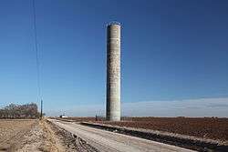 CRMWA water tower north of Smyer | |
 Smyer | |
| Coordinates: 33°35′03″N 102°09′48″W / 33.58417°N 102.16333°WCoordinates: 33°35′03″N 102°09′48″W / 33.58417°N 102.16333°W[1] | |
| Country |
|
| State |
|
| County | Hockley |
| Region | Llano Estacado |
| Established | 1917 |
| Area | |
| • Total | 0.80 sq mi (2.06 km2) |
| • Land | 0.80 sq mi (2.06 km2) |
| • Water | 0.0 sq mi (0.0 km2) |
| Elevation[1] | 3,389 ft (1,033 m) |
| Population (2010) | |
| • Total | 474 |
| • Density | 595/sq mi (229.7/km2) |
| Time zone | UTC-6 (CST) |
| ZIP code | 79367 |
| Area code | 806 |
| FIPS code | 48-68504 |
| GNIS feature ID | 1368526 |
Smyer is a town in Hockley County, Texas, United States. The population was 474 at the 2010 census.[2]
History
In 1902, Isaac L. Ellwood acquired 262,000 acres (1,060 km2) in Hockley and Lamb counties and formed the Spade Ranch.[3] The ranch, located deep within the heart of the Llano Estacado, was 10 mi (16 km) wide by 54 mi (87 km) long. The ranch's main headquarters was located in southeastern Lamb County, and the south pasture operations were headed up in eastern Hockley County, near present-day Smyer. The town of Smyer was founded in 1924 when William L. Ellwood began selling portions of the Spade Ranch to farmers. The town was platted in 1925 and named after Clinton E. Smyer, a Santa Fe Railroad division superintendent.[3]
Geography
Smyer is located on the high plains of the Llano Estacado at 33°35′03″N 102°09′48″W / 33.58417°N 102.16333°W (33.5842563 -102.1632291),[4] in eastern Hockley County. Texas State Highway 114 passes through the southern side of the town, leading west 16 miles (26 km) to Levelland, the county seat, and east 17 miles (27 km) to Lubbock.
According to the United States Census Bureau, Smyer has a total area of 0.81 square miles (2.1 km2), all of it land.[2]
Demographics
| Historical population | |||
|---|---|---|---|
| Census | Pop. | %± | |
| 1970 | 265 | — | |
| 1980 | 455 | 71.7% | |
| 1990 | 442 | −2.9% | |
| 2000 | 480 | 8.6% | |
| 2010 | 474 | −1.2% | |
| Est. 2016 | 475 | [5] | 0.2% |
| U.S. Decennial Census[6] | |||
As of the census[7] of 2000, there were 480 people, 179 households, and 141 families residing in the town. The population density was 617.3 people per square mile (237.6/km²). There were 215 housing units at an average density of 276.5 per square mile (106.4/km²). The racial makeup of the town was 81.88% White, 2.08% African American, 1.25% Native American, 13.12% from other races, and 1.67% from two or more races. Hispanic or Latino of any race were 29.17% of the population.
There were 179 households out of which 39.1% had children under the age of 18 living with them, 55.9% were married couples living together, 17.9% had a female householder with no husband present, and 20.7% were non-families. 19.6% of all households were made up of individuals and 10.1% had someone living alone who was 65 years of age or older. The average household size was 2.68 and the average family size was 3.04.
In the town, the population was spread out with 32.1% under the age of 18, 6.0% from 18 to 24, 27.3% from 25 to 44, 21.9% from 45 to 64, and 12.7% who were 65 years of age or older. The median age was 37 years. For every 100 females, there were 94.3 males. For every 100 females age 18 and over, there were 84.2 males.
The median income for a household in the town was $30,667, and the median income for a family was $32,000. Males had a median income of $23,594 versus $20,313 for females. The per capita income for the town was $11,784. About 16.4% of families and 17.3% of the population were below the poverty line, including 26.9% of those under age 18 and 3.8% of those age 65 or over.
Education
The town is served by the Smyer Independent School District.
See also
References
- 1 2 "Smyer". Geographic Names Information System. United States Geological Survey.
- 1 2 "Geographic Identifiers: 2010 Census Summary File 1 (G001): Smyer town, Texas". American Factfinder. U.S. Census Bureau. Retrieved March 13, 2018.
- 1 2 "Smyer, Texas". Handbook of Texas Online. Retrieved 2011-09-15.
- ↑ "US Gazetteer files: 2010, 2000, and 1990". United States Census Bureau. 2011-02-12. Retrieved 2011-04-23.
- ↑ "Population and Housing Unit Estimates". Retrieved June 9, 2017.
- ↑ "Census of Population and Housing". Census.gov. Retrieved June 4, 2015.
- ↑ "American FactFinder". United States Census Bureau. Retrieved 2008-01-31.
External links
Municipalities and communities of Hockley County, Texas, United States | ||
|---|---|---|
| Cities | 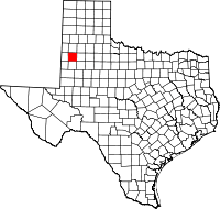 | |
| Towns | ||
| Unincorporated communities | ||