Eagle Farm, Queensland
| Eagle Farm Brisbane, Queensland | |||||||||||||||
|---|---|---|---|---|---|---|---|---|---|---|---|---|---|---|---|
| Population | 0 (2011 census)[1] | ||||||||||||||
| Postcode(s) | 4009 | ||||||||||||||
| Location | 9 km (6 mi) from Brisbane | ||||||||||||||
| LGA(s) |
City of Brisbane (Hamilton Ward)[2] | ||||||||||||||
| State electorate(s) | Clayfield | ||||||||||||||
| Federal Division(s) | Lilley | ||||||||||||||
| |||||||||||||||
Eagle Farm is a largely industrial suburb of Brisbane in Queensland, Australia, situated around six kilometres north-east of the Brisbane central business district. It is the former site of Eagle Farm Airport, which served as Brisbane's main airport until the opening of the Brisbane Airport in 1988. Eagle Farm was also the site of the disused Eagle Farm railway station. The locality of Whinstanes is located in Eagle Farm.[3] Eagle Farm is within the industrial-development zone known as Australia TradeCoast.
Eagle Farm Racecourse, home of the Queensland Turf Club (QTC) and the main racecourse for thoroughbred gallopers in Brisbane, is located in nearby Ascot.
History
Eagle Farm first appeared as a name in 1839, identifying a cultivation area in convict era Brisbane. In 1829 Captain Patrick Logan, chose this well-watered, fertile site between the Brisbane River and Serpentine Creek to farm mostly maize, pigs and cattle. The origin of the name apparently arose from eagles being observed around the farm. By 1834 women prisoners were working as field labour at Eagle Farm. By 1836 forty female prisoners were housed there, washing and mending clothes, growing vegetables. The site remained a prison for twice convicted female felons until transportation ended in 1839. Conditions for the females at the prison were documented by the Quaker missionary Backhouse in 1836.[3]
In the 1850s, Aborigines set up camps in the Breakfast Creek Eagle Farm area, including groups of the Bribie Island, Ningy-Ningy (Toorbul Point to Redcliffe) and Wide Bay Aborigines who were losing their traditional territory further north.[4]
Allison Engine Testing Stands
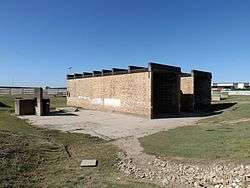
The Allison Engine testing stands site is part of Brisbane's TradeCoast Central at the old Brisbane airport site in the suburb of Eagle Farm, where new and rebuilt World War II Allison V-12 in-line liquid cooled aero engines were tested in the open air prior to fitting into reassembled WW2 aircraft, notably the P38-Lightning, Curtis Kittyhawk and Bell Airacobra. The masonry sections of the remains, being buildings and dividers between the engine testing bays, are largely intact. The engines were refurbished in the General Motors Holden (GMH) Breakfast Creek facility. Many of the workers in the GMH facility were women.[5][6]
Heritage listings
Eagle Farm has a number of heritage-listed sites, including:
Sport
The Royal Queensland Golf Club is located at 431 Curtin West Avenue.[10]
See also
References
- ↑ Australian Bureau of Statistics (31 October 2012). "Eagle Farm (State Suburb)". 2011 Census QuickStats. Retrieved 25 October 2013.

- ↑ "Hamilton Ward". Brisbane City Council. Brisbane City Council. Retrieved 12 March 2017.
- 1 2 Queensland Places
- ↑ Fisher, Rod. "From depredation to degradation in Brisbane: The Aboriginal presence 1824–1860", Brisbane History Group, 1992
- ↑ Hangar 7, Eagle Farm Aviation Society
- ↑ Marks, Roger. "Allison Engine Plant Breakfast Creek", Book 18, Brisbane – WW2 v Now, 2006
- ↑ "Allison Testing Stands (former) (entry 602329)". Queensland Heritage Register. Queensland Heritage Council. Retrieved 19 June 2013.
- ↑ "Eagle Farm Women's Prison and Factory Site (entry 600186)". Queensland Heritage Register. Queensland Heritage Council. Retrieved 19 June 2013.
- ↑ "Second World War Hangar No. 7 (entry 601007)". Queensland Heritage Register. Queensland Heritage Council. Retrieved 19 June 2013.
- ↑ "Royal Queensland Golf Club". Royal Queensland Golf Club. Retrieved 22 May 2014.
External links
| Wikimedia Commons has media related to Eagle Farm, Queensland. |
- "Eagle Farm". BRISbites. Brisbane City Council. Archived from the original on 20 July 2008.
- "Eagle Farm". Our Brisbane. Brisbane City Council. Archived from the original on 12 February 2008.
- Queensland Turf Club
- TradeCoast Central Heritage Park