Sudamdih
| Sudamdih | |
|---|---|
| Neighbourhood in Dhanbad | |
 Sudamdih  Sudamdih | |
| Coordinates: 23°39′16″N 86°26′26″E / 23.6545°N 86.4406°ECoordinates: 23°39′16″N 86°26′26″E / 23.6545°N 86.4406°E | |
| Country | India |
| State | Jharkhand |
| District | Dhanbad |
| Subdistrict | Jharia |
| Time zone | UTC+05:30 (IST) |
| Pincode | 828126[1] |
| Website |
dhanbad |
Sudamdih is a neighbourhood in Dhanbad in Jharkhand state, India.[2][3]
Geography
Sudamdih is located at 22°39′26″N 86°26′07″E / 22.65722°N 86.43536°E. Its average elevation is 146.8 m (482 ft) above Sea level.
Sudamdih was combined with other urban units to form Dhanbad Municipal Corporation in 2006.[4][5]Sudamdih is part of Ward No. 51 of Dhanbad Municipal Corporation.[6]
It is 18 km from Dhanbad, 5 km from Sindri, 7 km from Bhaga, 31 km from Adra, 200 km from Khargapur, 212 km from Tatanagar.
It is a developing town which comes under Bharat Cooking Coal Limited's Urban Project. The Damodar River flows along Sudamdih village and divides it from Bokaro.
Police station
Economy
Coal mines
Various projects have been going on for utilization of coal which is present in huge amount in Dhanbad. Bharat Coking Coal Limited (BCCL) is a subsidiary of Coal India Limited with its headquarters in Dhanbad, works the Sudamdih coal mines since nationalization of coalmines in 1971. It is a more than a century old underground shaft mine and washery.[8] Due to the presence of coal washery, the Damodar river is badly polluted, making its water unusable for local community.
Collieries in the East Jharia Area of BCCL are: Bhowrah North underground mine, Bhowra South colliery, Sudamdih Inclined Mine, Sudamdih Shaft Mine, Pathardih Colliery and Amlabad colliery/ project. East Jharia Area has a reserve of 508.493 million tonnes.[9]
About 17.85 hectares of East Jharia Area are affected by fire and subsidence, because of primitive methods of mining at shallow depths in the pre-nationalization era. All the quarries and subsidized areas affected by fire at Sudamdih and Pathardih have been filled up.[9]
Mining has been going on in the underground mines in this area for about 100 years. Working conditions in these mines being amongst the most difficult in the world, good quality prime coking coal in the lower seams still remain untapped.[9]
Transport
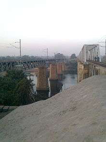
Sudamdih railway station is on the Railways in Jharia Coalfield.
Trekkers and state buses are available, which connect Sudamdih to Jharia, Dhanbad, Bhaga and Sindri.
References
- ↑ "Pin Code Sudamidh, Dhanbad, Jharkhand". PINcode.org.in. Retrieved 2015-03-11.
- ↑ "Dhanbad Municipal Corporation". DMC. Retrieved 15 October 2017.
- ↑ "Dhanbad Dsitrict Map". Physical Map of Dhanbad. Jharkhand Government. Archived from the original on 5 October 2017. Retrieved 15 October 2017.
- ↑ "Dhanbad Municipal Corporation". DMC. Retrieved 15 October 2017.
- ↑ "Dhanbad Dsitrict Map". Physical Map of Dhanbad. Jharkhand Government. Archived from the original on 5 October 2017. Retrieved 15 October 2017.
- ↑ "Dhanbad Municipal Corporation". प्रादेशिक निर्वाचन क्षेत्रों की सूची (in Hindi). Jharkhand Government. Archived from the original on 28 October 2017. Retrieved 19 October 2017.
- ↑ "Dhanbad – Welcome to the Coal Capital of India". Administrative Structure of Dhanbad District – List of Thana and Outpost of Dhanbad Outpost. Jharkhand Government. Archived from the original on 24 October 2017. Retrieved 15 October 2017.
- ↑ Anindita Ghose (22 June 2012). "The dark ages". Livemint. Retrieved 3 July 2012.
- 1 2 3 "Bharat Coking Coal Limited". East Jharia Area. BCCL. Retrieved 25 October 2017.