References
|
|---|
|
|
|---|
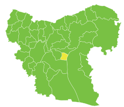
| Jabal Samaan Subdistrict |
- Aleppo
- Abtin
- Assan
- Ayn al-Kabira
- Azzan
- Duwayr al-Zaytun
- Haddadin
- Hilan
- Hreibel
- Kafr Saghir
- Khan Tuman
- Maghayer Khan Tuman
- Maratat al-Muslimiyah
- al-Muslimiyah
- al-Muslimiyah al-Shamaliyah
- Qarras
- Rasm Assan
- Saqlaya
- Siefat
- Tell Shair Samaan
- Tell Shughayb
- al-Dhahabiyah
- al-Wadihi
|
|---|
| Tell al-Daman Subdistrict |
- Tell al-Daman
- Abu Rweil
- Ameriyeh
- Arjel
- Atshana Sharqiya
- Atshana Gharbiya
- Ballas
- Ballas al-Jadida
- Batranah
- Burda
- Buwaida Saghira
- Deir Saliba
- Hmeidi
- Hober
- Jubb Aleis
- Kafr Obeid
- al-Mintar
- Mreiqes
- Oweinat Kabira
- Rasm al-Mofakker
- Tabara al-Khusheir
- Um al-Karamel
|
|---|
| Haritan Subdistrict | |
|---|
| Darat Izza Subdistrict |
- Darat Izza
- Bshantara
- Basrtun
- Bishqatin
- Kafrantin
- al-Hoteh
- Hur
- Injarah
- Qabtan al-Jabal
- al-Sakhriyah
- Taqad
|
|---|
| al-Hadher Subdistrict | |
|---|
| al-Zirbah Subdistrict |
- al-Zirbah
- Abad
- Arada
- Banes
- Barnah
- Barqum
- Bawabiyah
- Humayrah
- Huweir al-Eiss
- Jazraya
- Jubb Kas
- Kassibeh
- Othmaniya Kabira
- Rasm al-Eiss
- Talafeh
- Tell Allush
- Tell Hidyah
- Zitan
- Ziyara Samaan
|
|---|
| Zammar Subdistrict | |
|---|
|
| |
|
|
|---|
| Afrin Subdistrict | |
|---|
| Bulbul Subdistrict |
- Bulbul
- Burj Haider
- Darmashkanli
- Deir Ballut
- Fafertin
- Jalbul
- Kimar
- Karzahayel
|
|---|
| Jandairis Subdistrict | |
|---|
| Maabatli Subdistrict | |
|---|
| Rajo Subdistrict | |
|---|
| Sharran Subdistrict | |
|---|
| Shaykh al-Hadid Subdistrict | |
|---|
|
|
|
|
|
|
|---|
| Dayr Hafir Subdistrict | |
|---|
| Kuweires Sharqi Subdistrict | |
|---|
| Rasm Harmil al-Imam Subdistrict | |
|---|
|
|
|
|
|
|---|
| As-Safira Subdistrict | |
|---|
| Banan Subdistrict | |
|---|
| al-Hajib Subdistrict | |
|---|
| Khanasir Subdistrict | |
|---|
| Tell Aran Subdistrict | |
|---|
|
|