Al-Malikiyah
| Al-Malikiyah المالكية Dêrika Hemko | |
|---|---|
| City | |
 North east | |
| Nickname(s): ديريك | |
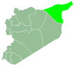
 Al-Malikiyah Location in Syria | |
| Coordinates: 37°10′N 42°08′E / 37.167°N 42.133°E | |
| Country |
|
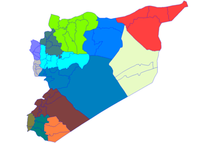
| Governorate | Al-Hasakah Governorate |
| District | Al-Malikiyah District |
| Nahiyah | Al-Malikiyah |
| de facto |
|
| Elevation | 500 m (1,640 ft) |
| Population (2012) | |
| • Total | 40,000 |
| Time zone | UTC+2 (EET) |
| • Summer (DST) | +3 |
| Area code(s) | 052 |
Al-Malikiyah (Arabic: المالكية Al Mālikiyah, Classical Syriac: ܕܪܝܟ, Dayrik, Kurdish: Dêrika Hemko) is a small Syrian city and the center of an administrative district belonging to Al-Hasakah Governorate. The district constitutes the northeastern corner of the country, and is where the Syrian Democratic Council convenes. The town is about 20 km (12 mi) west of the Tigris river which defines the triple border between Syria, Turkey and Iraq. According to the Syria Central Bureau of Statistics (CBS), Al-Malikiyah had a population about 40,000 residents in the 2012 census. It is the administrative center of a nahiyah ("subdistrict") consisting of 108 localities with a combined population of 125,000.The population enjoys demographic and ethnic diversity that is characteristic of most of Al-Hasakah Governorate. The town is inhabited by Kurds, Assyrians, Arabs and Armenians.
Etymology
The name of the town, "Al-Malikiyah", is named after a Syrian army officer Adnan al-Malki. The original native name is a matter of controversy. The Kurdish name Dêrika stands for tumbleweed, which is ubiquitous in the region. The alternative name, "Dayrik", is presented as a Kurdish deformation of the Syriac-Aramaic word for monastery, "Dayr".
History
The town's indigenous people are Assyrians who trace their ancestry to many Turkish villages in (Tur Abdin) whose inhabitants fled to Syria and established the city after the Assyrian Genocide. Assyrians began to emigrate from the area after the Amuda massacre of August 9, 1937. In 1941, the Assyrians of Malikiya were subjected to a vicious assault. Even though it failed, fear, anxiety and the immigration of Kurds from Turkey led to Malikiya, Darbasiya and Amuda becoming predominantly Kurdish.[1][2]
As of 2004, Al-Malikiyah is the fifth largest city in Al-Hasakah governorate.
Syrian Civil War
As a preliminary result of the ongoing Syrian Civil War, Al-Malikiyah today is situated in Jazira Canton within the autonomous Democratic Federation of Northern Syria framework. YPG forces on 21 July reportedly captured Al-Malikiyah, which is located just 10 kilometers from the Turkish border.[3] Although another report stated that fighting was ongoing in the city.[4] On 22 July 2012, it was reported that Kurdish forces were still fighting for Al-Malikiyah where one young Kurdish activist was killed after government security forces allegedly opened fire on protesters.[5] In November 2012 the Syrian government forces withdrew from the city.
Demographics
In 2004 the population of Al-Malikiyah was 26,311. The population consists mostly of ethnic Kurds and Assyrians in addition to a significant, large number of Arabs and a smaller number of Armenians. The northern half of the town is mainly inhabited by Muslim Kurds, and the southern part by the Assyrians and Armenians. As the economic center of the district, the town is usually filled with people from the surrounding villages and towns, especially during the morning hours. Al-Malikiyah has seen a dramatic urban expansion and real estate development in recent years which led to many streets being extended to new neighborhoods that are now part of the continually growing town.
As of November 2014, only 200 ethnic Armenians remain in the city out of a pre-civil war figure of 450.[6]
Gallery
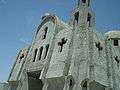 New Syriac Orthodox Church on Main street
 New Church dome
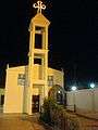 Chaldean Catholic Church
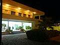 Chaldean Catholic Church and School Building
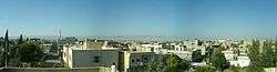
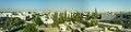 Looking east
References
| Wikimedia Commons has media related to Al-Malikiyah. |
- ↑ "صقر ابو فخر | التراجع المسيحي في الشرق: مشهد تاريخي :: | جريدة السفير". Assafir.com. 2013-12-19. Retrieved 2017-05-01.
- ↑ "Notes on Arab Orthodoxy: As-Safir on the History of the Persecution of Middle Eastern Christians". Araborthodoxy.blogspot.ca. 2013-12-22. Retrieved 2017-05-01.
- ↑ "City of Derik taken by Kurds in Northeast Syria". En.firatnews.com. Archived from the original on 2012-08-02. Retrieved 2013-08-29.
- ↑ "Ban: Syrian regime 'failed to protect civilians'". Edition.cnn.com. 22 July 2012. Retrieved 2013-08-29.
- ↑ "Armed Kurds Surround Syrian Security Forces in Qamishli". Rudaw.net. Retrieved 2013-08-29.
- ↑ "Demoralized, Syrian refugees return home | Middle East | DW.COM | 17.11.2014". Dw.de. Retrieved 2017-05-01.