Izra
| Izra' ازرع | |
|---|---|
| Town | |
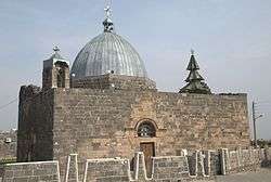 The Basilica of St. George in Izra' | |
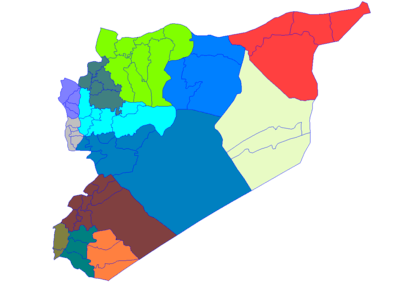
 Izra' Location in Syria | |
| Coordinates: 32°50′43.45″N 36°14′59.48″E / 32.8454028°N 36.2498556°ECoordinates: 32°50′43.45″N 36°14′59.48″E / 32.8454028°N 36.2498556°E | |
| Grid position | 267/253 PAL |
| Country |
|
| Governorate | Daraa Governorate |
| District | Izra' District |
| Nahiyah | Izra' |
| Elevation | 600 m (1,968 ft) |
| Population (2004 census) | |
| • Total | 19,158 |
| Time zone | UTC+2 (EET) |
| • Summer (DST) | +3 |
Izra' (Arabic: ازرع Izra') is a town in the Daraa Governorate of Syria, to the north of the city of Daraa. It is the administrative centre of the Izra' District, and sits at an altitude of 599 metres. Izra' had a population of 19,158 in 2004, according to the Syria Central Bureau of Statistics (CBS).[1] The population was predominantly Christian but now it is mixed with the majority being Muslims.
History
Izraa (Zorava, Zorowa or Zorabene) was a Canaanite city mentioned in the Bible. Located 80 km south of Damascus in the northern section of the Province of Daraa, its name appears in the Tell Amarna letters, documents which were exchanged between the Egyptian and Syrian rulers in 1334 B.C. Ancient inscriptions left by the Romans after their occupation of the Bashan area evidence the importance of the town.
An inscription found by the archaeologist Richter shows that the city was elevated to the rank of metrokomia (Great city) under the Emperor Alexander Severus (222-235 A.D.) and was known as Zorava.[2]
Lejah (Trachonides or "the Rocky Land") forms a triangle with Borac as the northern apex, Izraa in the south-western corner and Shahba in the south-eastern corner.[3] In the course of history, this region was a natural fortress that invaders found very difficult to conquer. Herod’s soldiers failed to occupy it. Even the Crusaders under Baldwin III could not subdue it, because of its difficult terrain, the lack of water and the resistance of its people.
The Christian Gospel reached this region early because of its proximity to the Holy Land. It became an episcopal seat during the Byzantine era, and ranked second after the metropolitan see of Bosra throughout the whole of the Province of Arabia.[4]
In 1253 An-Nasir Yusuf ordered the roofing of the Friday mosque in Izra.[5]
The historian Ismail Abulfida described in his book Taqwim al Buldan that it was “to be one of the major capitals of Hauran, 18 miles from the region of Sanameine”.
In 1596 Izra' appeared in the Ottoman tax registers as Madinat Zura' and was part of the nahiya of Badi Sarma in the Qada of Hauran. It had a Christian population consisting of 175 households and 61 bachelors, and a Muslim population of 59 households and 30 bachelors. Taxes were paid on wheat, barley, goats and/or beehives, water mill and jizya.[6]
In 1840 CE the Egyptian ruler Ibrahim Pasha invaded the region and bombarded the church, causing great damage to the walls and dome, but he failed to occupy the city. During the great Syrian insurrection against the French Mandate forces (1925-1926), the rebels sought refuge in Izraa.[7]
Demographics
The town has a population of 19,158 based on the 2004 census. It is composed of Christians and Muslims.
Landscape
Izra can have very strong (vii) earthquakes (on average one every 50 years) with occurrences at 6-7 Richter. When a strong earthquake occurs, it will be difficult to stand and noticed by people driving motor cars. Furniture and glass will be broken. The damage will be negligible in buildings of good design and construction but considerable damage may be inflicted on poorly built or badly designed structures. There is a very high occurrence of periods with extreme drought. Izra` has a semi-arid (0.2 - 0.5 p/pet) climate. The land area is totally cultivated, not much natural vegetation is left. The landscape is mostly covered with mosaic forest - shrubland/grassland. The climate is classified as a mid-latitude steppe (mid-latitude dry), with a subtropical desert scrub biozone. The soil in the area is high in leptosols (lp), a weakly developed shallow soil.[8]
Climate
In Izra, there is a local steppe climate. Rainfall is higher in winter than in summer. The Köppen-Geiger climate classification is BSk. The average annual temperature in Izra is 17.3 °C (63.1 °F). About 287 mm (11.30 in) of precipitation falls annually.
| Climate data for Izra | |||||||||||||
|---|---|---|---|---|---|---|---|---|---|---|---|---|---|
| Month | Jan | Feb | Mar | Apr | May | Jun | Jul | Aug | Sep | Oct | Nov | Dec | Year |
| Average high °C (°F) | 13.1 (55.6) |
14.8 (58.6) |
18.2 (64.8) |
23.0 (73.4) |
28.4 (83.1) |
31.9 (89.4) |
33.0 (91.4) |
33.5 (92.3) |
32.0 (89.6) |
28.3 (82.9) |
21.8 (71.2) |
15.1 (59.2) |
24.4 (76) |
| Average low °C (°F) | 2.9 (37.2) |
3.4 (38.1) |
5.8 (42.4) |
8.7 (47.7) |
12.1 (53.8) |
15.0 (59) |
17.1 (62.8) |
17.4 (63.3) |
15.3 (59.5) |
12.1 (53.8) |
8.0 (46.4) |
4.4 (39.9) |
10.2 (50.3) |
| Average precipitation mm (inches) | 65 (2.56) |
58 (2.28) |
49 (1.93) |
16 (0.63) |
6 (0.24) |
0 (0) |
0 (0) |
0 (0) |
0 (0) |
7 (0.28) |
27 (1.06) |
59 (2.32) |
287 (11.3) |
| Source: Climate-Data.org,Climate data | |||||||||||||
References
- ↑ General Census of Population and Housing 2004. Syria Central Bureau of Statistics (CBS). Daraa Governorate. (in Arabic)
- ↑ Five years in Damascus and Hauran, Rev. J. L. Porter, 1855.
- ↑ L’Orient Romain, M. Sartre
- ↑ L’Arabie chrétienne, M. Picirillo, Mengès, 2002.
- ↑ Sharon, 2007, p. 165
- ↑ Hütteroth and Abdulfattah, 1977, p. 217.
- ↑ Bostra, des origines à l’Islam, M. Sartre, Paris, 1985.
- ↑ http://www.chinci.com/#1%7C0%7Ctravel%7Cpa%7C0%7C169341%7CIzra`%7CSY%7CSyria%7CAsia/Damascus%7CSY.06%7CPPL%7C32.8577778%7C36.2544444%7CDaraa Archived 2013-10-12 at the Wayback Machine.
Bibliography
| Wikimedia Commons has media related to Izra. |
- Hütteroth, Wolf-Dieter; Abdulfattah, Kamal (1977). Historical Geography of Palestine, Transjordan and Southern Syria in the Late 16th Century. Erlanger Geographische Arbeiten, Sonderband 5. Erlangen, Germany: Vorstand der Fränkischen Geographischen Gesellschaft. ISBN 3-920405-41-2.
- Sharon, Moshe (2007). Corpus Inscriptionum Arabicarum Palaestinae, Addendum. BRILL. ISBN 978-90-04-15780-4.
External links
- Map of town, Google Maps
- Ezra-map, 20M
Capital: Daraa | |||||||||||||||||||||
| |||||||||||||||||||||
| |||||||||||||||||||||
| |||||||||||||||||||||