Cities, towns and villages
|
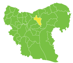
Cities, towns and villages of Arima Subdistrict
| PCode | Name | Population |
|---|
| C1329 | Arima | 2,839 |
| C1339 | Sukkariyah Kabira | 2,437 |
| C1322 | Sukkariyah Saghira | 2,332 |
| C1331 | Iylan | 2,117 |
| C1333 | Qanli Quyu | 1,550 |
| C1346 | Barshaya | 1,448 |
| C1344 | Shuwayhah | 1,375 |
| C1325 | Hajaliyah | 1,211 |
| C1338 | Orubah | 1,186 |
| C1348 | Bir Tafreeah | 1,089 |
| C1330 | Kreidiyeh | 1,037 |
| C1337 | Jeb Naassan | 1,011 |
| C1350 | Madiq Bu Azar | 876 |
| C1327 | Jurneyyeh | 829 |
| C1343 | Shdar | 778 |
| N/A | Birazia | 774 |
| C1349 | Big Nabata | 764 |
| C1335 | Jeb Sultan | 741 |
| C1340 | Jablet Elhamra | 736 |
| C1341 | Um Shakif | 691 |
| N/A | Al-Dhdhib | 678 |
| C1342 | Um Adae Ajami | 675 |
| C1328 | Olasha | 632 |
| C1347 | Little Tafreeah | 622 |
| N/A | Al-Buwwaihij | 607 |
| C1326 | Omyaniye - Korhyok | 518 |
| C1334 | Wadi - Little Jqal | 425 |
| C1332 | Sunbula - Saboyran | 392 |
| C1345 | Tarhin | 392 |
| N/A | Ajami | 385 |
| C1323 | Hota | 327 |
| C1324 | Mazrufeh | 288 |
| N/A | Qanafidah | 198 |
| C1336 | Thalabiyeh - Big Jqal | 81 |
References
|
|---|
|
|
|---|
| Jabal Samaan Subdistrict |
- Aleppo
- Abtin
- Assan
- Ayn al-Kabira
- Azzan
- Duwayr al-Zaytun
- Haddadin
- Hilan
- Hreibel
- Kafr Saghir
- Khan Tuman
- Maghayer Khan Tuman
- Maratat al-Muslimiyah
- al-Muslimiyah
- al-Muslimiyah al-Shamaliyah
- Qarras
- Rasm Assan
- Saqlaya
- Siefat
- Tell Shair Samaan
- Tell Shughayb
- al-Dhahabiyah
- al-Wadihi
|
|---|
| Tell al-Daman Subdistrict |
- Tell al-Daman
- Abu Rweil
- Ameriyeh
- Arjel
- Atshana Sharqiya
- Atshana Gharbiya
- Ballas
- Ballas al-Jadida
- Batranah
- Burda
- Buwaida Saghira
- Deir Saliba
- Hmeidi
- Hober
- Jubb Aleis
- Kafr Obeid
- al-Mintar
- Mreiqes
- Oweinat Kabira
- Rasm al-Mofakker
- Tabara al-Khusheir
- Um al-Karamel
|
|---|
| Haritan Subdistrict | |
|---|
| Darat Izza Subdistrict |
- Darat Izza
- Bshantara
- Basrtun
- Bishqatin
- Kafrantin
- al-Hoteh
- Hur
- Injarah
- Qabtan al-Jabal
- al-Sakhriyah
- Taqad
|
|---|
| al-Hadher Subdistrict | |
|---|
| al-Zirbah Subdistrict |
- al-Zirbah
- Abad
- Arada
- Banes
- Barnah
- Barqum
- Bawabiyah
- Humayrah
- Huweir al-Eiss
- Jazraya
- Jubb Kas
- Kassibeh
- Othmaniya Kabira
- Rasm al-Eiss
- Talafeh
- Tell Allush
- Tell Hidyah
- Zitan
- Ziyara Samaan
|
|---|
| Zammar Subdistrict | |
|---|
|
| |
|
|
|---|
| Afrin Subdistrict | |
|---|
| Bulbul Subdistrict |
- Bulbul
- Burj Haider
- Darmashkanli
- Deir Ballut
- Fafertin
- Jalbul
- Kimar
- Karzahayel
|
|---|
| Jandairis Subdistrict | |
|---|
| Maabatli Subdistrict | |
|---|
| Rajo Subdistrict | |
|---|
| Sharran Subdistrict | |
|---|
| Shaykh al-Hadid Subdistrict | |
|---|
|
|
|
|
|
|
|---|
| Dayr Hafir Subdistrict | |
|---|
| Kuweires Sharqi Subdistrict | |
|---|
| Rasm Harmil al-Imam Subdistrict | |
|---|
|
|
|
|
|
|---|
| As-Safira Subdistrict | |
|---|
| Banan Subdistrict | |
|---|
| al-Hajib Subdistrict | |
|---|
| Khanasir Subdistrict | |
|---|
| Tell Aran Subdistrict | |
|---|
|
|