Fiq, Syria
| Fiq فيق | |
|---|---|
| Town | |
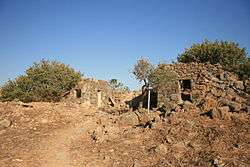 Ruins at Fiq | |
 Fiq Location of Fiq in Syria | |
| Coordinates: 32°46′N 35°42′E / 32.77°N 35.7°E | |
| Country |
|
| Governorate | Quneitra |
| District | Fiq |
| Subdistrict | Fiq |
| Population (1967)[1] | 2,800[2] |
| Time zone | UTC+2 (EET) |
| • Summer (DST) | UTC+3 (EEST) |
Fiq (Arabic: فيق) was a Syrian town in the Golan Heights that administratively belonged to Al Quneitra Governorate.[3] It sat at an altitude of 349 meters (1,145 ft) and had a population of 2,800 in 1967. It was the administrative center of the Fiq District of Al Quneitra. In and after the Six-Day War in June 1967, it was evacuated. The Israeli settlement of Kibbutz Afik was built close by.[3]
History
Fiq was an ancient town, covering about 100 dunams on an artificial mound. Many inscriptions in Latin and Greek have been found.[4]
Fiq was located on one of the few routes connecting the Galilee and the Golan Heights, all part of the very important network of roads between Egypt and Syria. The lower part of the road followed the "Ascent of Fiq" (Arabic: 'Aqabat Fiq) where the Ayyubids built a khan in the early 13th century, Khan al-'Aqabah, whose ruins are still visible. Once it reached the plateau, the road passed through different villages, the branch going through Fiq leading eastwards to the Hauran region rather than northeastwards to Damascus.[5]
Around 1225, Yakut noted that the convent of Dayr Fiq was much venerated by Christians, and still frequented by travellers.[6]
In 1596 Fiq appeared in the Ottoman tax registers as part of the nahiya of Jawlan Garbi in the Qada of Hauran. It had an entirely Muslim population consisting of 16 households and 9 bachelors. Taxes were paid on wheat, barley, summer crops, olive trees, goats and/or beehives.[7]
In 1806, the German explorer Seetzen found that Fiq had 100 houses made of basalt, four them the inhabited by Christians and the rest by Muslims.[8]
In 1875, the French explorer Victor Guérin found that Fiq was divided into four quarters, each administered by its own sheik. Most of the homes contained remnants of ancient buildings. The village had abundant of fresh water.[9]
When Gottlieb Schumacher surveyed the area in the 1880s, he described Fiq as a large village with about 400 people. It had around 160 "tolerably" well-built stone houses, but only 90 of those were inhabited.[10]
At the time of its depopulation in 1967, the city had a population of approximately 2,800.[2]
Archaeology and possible mention in the Bible
The name Aphek refers to one or several locations mentioned by the Hebrew Bible as the scenes of a number of battles between the Israelites and the Arameans. Most famously, a town near which one or more rulers of Damascus named Ben-hadad, were defeated by the Israelites and in which the Damascene king and his surviving soldiers found a safe place of retreat (1 Kings 20:26-30; 2 Kings 13:17, 24-25).
Since the turn of the 20th century the predominant opinion is that the location of all these battles is one and the same, and that the town lay east of the Jordan. Initially it was thought that the name is preserved in the now depopulated village of Fiq near Kibbutz Afik, three miles east of the Sea of Galilee, where an ancient mound, Tell Soreg, had been identified. Excavations by Moshe Kochavi and Pirhiya Beck in 1987-88 have indeed discovered a fortified 9th- and 8th-century BCE settlement, probably Aramean, but Kochavi considered it to be too small to serve the role ascribed to Aphek in the Bible.[11][12] The site most favoured now by the archaeologists is Tel 'En Gev/Khirbet el-'Asheq, a mound located within Kibbutz Ein Gev.[13]
References
- ↑ "2004 Census Data for Nahiya Fiq" (in Arabic). Syrian Central Bureau of Statistics. Missing or empty
|url=(help);|access-date=requires|url=(help) Also available in English: UN OCHA. "2004 Census Data". Humanitarian Data Exchange. Retrieved 4 December 2015. - 1 2 Yigal Kipnis (2013). The Golan Heights. London and New York: Routledge. p. 244.
- 1 2 Urman 1998, p. 578
- ↑ Dauphin, 1998, p. 722
- ↑ Moshe Sharon (2004). Corpus Inscriptionum Arabicarum Palaestinae. Brill Academic Publ. p. 217. ISBN 978-9004131972.
- ↑ le Strange, 1890, p. 429
- ↑ Hütteroth and Abdulfattah, 1977, p. 196.
- ↑ Ulrich Jasper Seetzen (1854). Fr. Kruse, ed. Reisen durch Syrien, Palästina, Phönicien, die Transjordan-Länder, Arabia Petraea and Unter-Aegypten. 1. Berlin: G. Reimer. p. 353.
- ↑ Guérin, 1880, pp 314-5 ff
- ↑ Schumacher, 1888, p. 136-7 ff
- ↑ The Golan Heights: A Battlefield of the Ages, LA Times, 11 September 1988
- ↑ Shuichi Hasegawa, Aram and Israel during the Jehuite Dynasty, Tel Soreg, p. 72
- ↑ Avraham Negev, Shimon Gibson (2001). Aphek (c). Archaeological Encyclopedia of the Holy Land. New York: Continuum. p. 39. ISBN 0-8264-1316-1.
Bibliography
- Dauphin, Claudine (1998). La Palestine byzantine, Peuplement et Populations. BAR International Series 726 (in French). III: Catalogue. Oxford: Archeopress.
- Davis, Uri (1983), "The Golan Heights under Israeli occupation 1967-1981" (PDF), Occasional papers series, Centre for Middle Eastern and Islamic Studies, Durham University, 18, ISSN 0307-0654
- Guérin, Victor (1880). Description Géographique Historique et Archéologique de la Palestine (in French). 3: Galilee, pt. 1. Paris: L'Imprimerie Nationale.
- Hütteroth, Wolf-Dieter; Abdulfattah, Kamal (1977). Historical Geography of Palestine, Transjordan and Southern Syria in the Late 16th Century. Erlanger Geographische Arbeiten, Sonderband 5. Erlangen, Germany: Vorstand der Fränkischen Geographischen Gesellschaft. ISBN 3-920405-41-2.
- Le Strange, Guy (1890). Palestine Under the Moslems: A Description of Syria and the Holy Land from A.D. 650 to 1500. Committee of the Palestine Exploration Fund.
- Pringle, Denys (2009). The Churches of the Crusader Kingdom of Jerusalem: Volume IV The cities of Acre and Tyre with Addenda and Corrigenda to Volumes I-III. Cambridge University Press. ISBN 978-0-521-85148-0. (pp. 240–241)
- Schumacher, Gottlieb (1888). The Jaulân: Surveyed for the German Society for the Exploration of the Holy Land. Cambridge University Press. ISBN 9781108017565.
- Sharon, Moshe (2004). Corpus Inscriptionum Arabicarum Palaestinae, Vol. III, D-F. Brill. (p. 206)
- Sharon, Moshe (2007). Corpus Inscriptionum Arabicarum Palaestinae, Addendum. Brill. (p. 93)
- Urman, Dan; Flesher, Paul Virgil McCracken (1998). Ancient Synagogues: Historical Analysis and Archaeological Discovery. Leiden: Brill Publishers. ISBN 978-90-04-11254-4. OCLC 42882859.
| Wikimedia Commons has media related to Ein Fiq. |
| Quneitra District |
| ||||||||
|---|---|---|---|---|---|---|---|---|---|
| Fiq District |
| ||||||||
| Syrian localities in Israeli-occupied Golan Heights |
| ||||||||
| Israeli localities in Israeli-occupied Golan Heights |
| ||||||||