Coopers Plains, Queensland
| Coopers Plains Brisbane, Queensland | |||||||||||||||
|---|---|---|---|---|---|---|---|---|---|---|---|---|---|---|---|
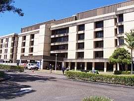 Queen Elizabeth II Jubilee Hospital, 2008 | |||||||||||||||
 Coopers Plains | |||||||||||||||
| Coordinates | 27°34′13″S 153°02′14″E / 27.5703°S 153.0372°ECoordinates: 27°34′13″S 153°02′14″E / 27.5703°S 153.0372°E | ||||||||||||||
| Population | 5,483 (2016 census)[1] | ||||||||||||||
| Postcode(s) | 4108 | ||||||||||||||
| Location | 11 km (7 mi) from Brisbane GPO | ||||||||||||||
| LGA(s) |
City of Brisbane (Moorooka Ward)[2] | ||||||||||||||
| State electorate(s) | Toohey | ||||||||||||||
| Federal Division(s) | Moreton | ||||||||||||||
| |||||||||||||||

Coopers Plains is an outer suburb of Brisbane, Australia. It is 11 kilometres (7 mi) south-west of the CBD. The suburb is home to the Queen Elizabeth II Jubilee Hospital.
History
The locality was originally called Cowper's Plains. It was named by John Oxley after Dr Henry Cowper, Assistant Surgeon-in-Charge at the Moreton Bay Settlement from 1823 to 1832.[3][4] A convict settlement was established at Cowper's Plains in 1828. The name was corrupted and by 1860 the area was known as Cooper's Plains.[5] By 1877 it was known as Coopers Plains.[6] The first post office opened in 1876.
Coopers Plains remained rural until the 1940s. The United States Army built a barracks adjacent to the railway station 1942, which after the war became the Australian Army's Damour Barracks.
The Coopers Plains Library opened in 1979 with a major refurbishment in 2014.[7]
Demographics
In the 2011 census the population of Coopers Plains was 4,208, 49% female and 51% male.[8] The median age of the Coopers Plains population was 34 years of age, three years below the Australian median. 57% of people living in Coopers Plains were born in Australia, compared to the national average of 69.8%. The other top responses for country of birth were India 6.2%, China 5.3%, New Zealand 2.9%, Philippines 2.2%, England 2.1%. 61.9% of people spoke only English at home; the next most popular languages were 6% Mandarin, 3.2% Cantonese, 2% Vietnamese, 1.6% Hindi, 1.3% Punjabi. The most popular religious affiliation was "no religion" (22%), followed by Catholic (21%) and Anglican (12%).[8]
Transport
Coopers Plains railway station on the South Coast railway line (now the Beenleigh line) opened in 1885.
There are several bus routes running through Coopers Plains – 120 (City – Garden City), 135 (City – Parkinson), 123 (Sunnybank), 598 and 599 (Great Circle Line), 124 and 125. Coopers Plains is also in very close proximity to the Griffith University Nathan Campus.
Institutions
The Health and Food Sciences Precinct (HFSP), at the Queensland Health Forensic and Scientific Services (QHFSS) campus, was opened in 2010, and would include the Queensland Centre for Emerging Infectious Diseases (QCEID).[9] The precinct is a research facility for the Queensland Department of Agriculture, Fisheries and Forestry, CSIRO, and Queensland University through the Queensland Alliance for Agriculture and Food Innovation (QAAFI).[10]
The Brisbane City Council operate a public library at 107 Orange Grove Road.[11]
References
- ↑ Australian Bureau of Statistics (27 June 2017). "Coopers Plains (Brisbane City) (State Suburb)". 2016 Census QuickStats.

- ↑ "Moorooka Ward". Brisbane City Council. Brisbane City Council. Retrieved 12 March 2017.
- ↑ "Early Moreton Bay. Some Place Names. How They Originated". The Brisbane Courier. 29 September 1923. p. 19.
- ↑ E.S. Jackson (1929). "Henry Cowper, Surgeon and his times". Proceedings of the Australian Medical Congress: 198–202.
- ↑ "LOCAL INTELLIGENCE". The Moreton Bay Courier. 17 January 1860. p. 2.
- ↑ "Coopers Plains". The Brisbane Courier. 27 August 1877. p. 6.
- ↑ "Public Libraries Statistical Bulletin 2016-17" (PDF). Public Libraries Connect. State Library of Queensland. November 2017. p. 11. Archived (PDF) from the original on 30 January 2018. Retrieved 30 January 2018.
- 1 2 Australian Bureau of Statistics (31 October 2012). "Coopers Plains (Brisbane City) (State Suburb)". 2011 Census QuickStats.
- ↑ "'Super Foods' Health and Food Sciences Precinct Opens". Ministerial Media Statement, August 2010. Department of the Premier and Cabinet, Queensland Government. Retrieved 21 June 2012.
- ↑ "Health and Food Sciences Precinct". Science in Queensland. Queensland Government. Retrieved 21 June 2012.
- ↑ "Library opening hours and locations". Brisbane City Council. 3 January 2018. Archived from the original on 30 January 2018. Retrieved 30 January 2018.
External links
| Wikimedia Commons has media related to Coopers Plains, Queensland. |