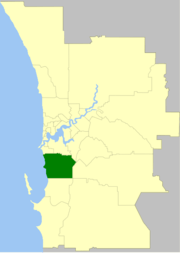
City of Cockburn
| City of Cockburn Western Australia | |||||||||||||||
|---|---|---|---|---|---|---|---|---|---|---|---|---|---|---|---|
 | |||||||||||||||
| Population | 104,473 (2016 census)[1] | ||||||||||||||
| • Density | 623.72/km2 (1,615.4/sq mi) | ||||||||||||||
| Established | 1871 | ||||||||||||||
| Area | 167.5 km2 (64.7 sq mi) | ||||||||||||||
| Mayor | Logan Howlett | ||||||||||||||
| Council seat | Spearwood | ||||||||||||||
| Region | South Metropolitan Perth | ||||||||||||||
| State electorate(s) | Cockburn, Fremantle, Jandakot, Willagee | ||||||||||||||
| Federal Division(s) | Fremantle | ||||||||||||||
|
| |||||||||||||||
| Website | City of Cockburn | ||||||||||||||
| |||||||||||||||
The City of Cockburn /koʊbɜːrn/ is a local government area in the southern suburbs of the Western Australian capital city of Perth about 8 kilometres (5 mi) south of Fremantle and about 24 kilometres (15 mi) south of Perth's central business district. The City covers an area of 167.5 square kilometres (64.7 sq mi) and had a population of over 104,000 as at the 2016 Census.
History
Cockburn is named after Cockburn Sound, which was named in 1827 by Captain James Stirling after Admiral Sir George Cockburn. Sir George was born in London in 1772 and was a renowned British naval officer, eventually becoming Admiral of the Fleet and First Sea Lord. He served under Horatio Nelson during the war with France, but came to public attention and was granted his knighthood for his service in the War of 1812, in particular for the burning of Washington in 1814. It was he who took Napoleon to exile on the island of Saint Helena after the Battle of Waterloo in 1815.[2]
In 1871, the Fremantle Road District was created under the District Roads Act 1871 to cover the area to the south and east of Fremantle, and the Fremantle Road Board was created to manage it. The original District was bounded on the north by the Swan River from Fremantle to the mouth of the Canning River; on the east by a line from Bull Creek to the junction of what is now the intersection of the Albany and South Western Highways in Armadale; on the south by a line from Armadale to, and including the Rockingham townsite; and to the west by the Indian Ocean.
In the first five years of the Board's existence most of its members served on the Fremantle Town Council. The function of the Board was simply to provide the roads that linked Fremantle to other parts of the Colony. By 1913 the District was divided into Wards, each electing representatives to the Board. In 1922 the Board constructed new offices at the corner of Forrest and Rockingham Roads.
In July 1923, the District received a large amount of land (gaining the localities of Atwell and Banjup and 75% of the Jandakot locality) from Jandakot Road District when that entity was abolished. On 21 January 1955, it was renamed Cockburn,[3] after a successful referendum underlined the desire for recognition of the District's independence from Fremantle.
On 1 July 1961, Cockburn Road District became a shire following the enactment of the Local Government Act 1960, and on 24 January 1971, almost exactly 100 years after the formation of the Fremantle Road District, it became a Town[4] in recognition of its increasingly urban nature. On 26 October 1979 the town attained City status.[5][6]
A public inquiry into corruption in the City of Cockburn was held in 1999.[7] The Council was suspended in April 1999 and dismissed on 30 June 2000, with administrators running the council until an election held on 6 December 2000.[8][9] In 2007 the City of Cockburn was again embroiled in controversy as alleged evidence of corruption arose at the Corruption and Crime Commission.
Wards
The city is divided into three wards, each electing three councillors. The mayor is directly elected.
- East Ward
- West Ward
- Central Ward
Population
| Year | Population |
|---|---|
| 1911 | 734 |
| 1921 | 1,278 |
| 1933 | 2,221 |
| 1947 | 3,049 |
| 1954 | 5,047 |
| 1961 | 7,827 |
| 1966 | 13,847 |
| 1971 | 25,011 |
| 1976 | 29,492 |
| 1981 | 31,705 |
| 1986 | 40,711 |
| 1991 | 50,217 |
| 1996 | 57,102 |
| 2001 | 65,996 |
| 2006 | 74,472 |
| 2011 | 89,683 |
Suburbs
Mayors
Sister cities
References
- ↑ Australian Bureau of Statistics (27 June 2017). "Cockburn (C)". 2016 Census QuickStats. Retrieved 26 November 2017.

- ↑ Morriss, Roger (1997), Cockburn and the British Navy in Transition, University of Exeter Press, ISBN 0-85989-526-2
- ↑ "Road Districts Act, 1919–1951. Fremantle Road District. Alteration of Name. (per L.G. 481/52)". Western Australia Government Gazette. 21 January 1955. p. 1955:132.
- ↑ "Local Government Act, 1960–1970. Shire of Cockburn. Change of Status. (per L.G. 39/66)". Western Australia Government Gazette. 24 December 1970. p. 1970:3842. Specifies 24 January 1971 as effective date.
- ↑ "Local Government Act, 1960–1978. Order in Council (per CC-1-10)". Western Australia Government Gazette. 31 August 1979. p. 1979:2607. Specifies 26 October 1979 as effective date.
- ↑ WA Electoral Commission, Municipality Boundary Amendments Register (release 3.0), 31 July 2007.
- ↑ Report of Inquiry into the City of Cockburn (April 2000)
- ↑ "City of Cockburn (Dismissal of Council) Order 2000". Western Australia Government Gazette. 30 June 2000. p. 2000:3422.
- ↑ Department of Local Government (4 May 2000). "City of Cockburn inquiry: Minister tables report (Media statement)". Retrieved 5 December 2009.
- ↑ "Gradovi prijatelji Splita" [Split Twin Towns]. Grad Split [Split Official City Website] (in Croatian). Archived from the original on 24 March 2012. Retrieved 19 December 2013.