Chatham, Massachusetts
| Chatham, Massachusetts | ||
|---|---|---|
| Town | ||
| ||
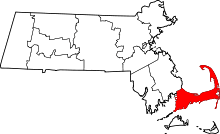
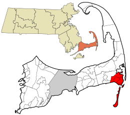 Location in Barnstable County and the state of Massachusetts. | ||
| Coordinates: 41°40′55″N 69°57′37″W / 41.68194°N 69.96028°WCoordinates: 41°40′55″N 69°57′37″W / 41.68194°N 69.96028°W | ||
| Country | United States | |
| State | Massachusetts | |
| County | Barnstable | |
| Settled | 1665 | |
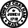
| Incorporated | 1712 | |
| Government | ||
| • Type | Open town meeting | |
| Area | ||
| • Total | 24.4 sq mi (63.2 km2) | |
| • Land | 16.1 sq mi (41.8 km2) | |
| • Water | 8.3 sq mi (21.4 km2) | |
| Elevation | 46 ft (14 m) | |
| Population (2010) | ||
| • Total | 6,125 | |
| • Density | 380/sq mi (146.6/km2) | |
| Time zone | UTC−5 (Eastern) | |
| • Summer (DST) | UTC−4 (Eastern) | |
| ZIP Code | 02633 | |
| Area code(s) | 508/774 | |
| FIPS code | 25-12995 | |
| GNIS feature ID | 0618250 | |
| Website |
www | |
Chatham is a town in Barnstable County, Massachusetts, United States. Chatham is located at the southeast tip of Cape Cod, and has historically been a fishing community. First settled by the English in 1664, the township was originally called Monomoit based on the indigenous population's term for the region.[1] Chatham was incorporated as a town on June 11, 1712, and has become a summer resort area. The population was 6,169 at the 2017 census, and can swell to 25,000 during the summer months.[2] There are four villages that comprise the town, those being Chatham (CDC), South Chatham, North Chatham, and West Chatham. Chatham is home to the Monomoy National Wildlife Refuge, and the decommissioned Monomoy Point Light both located on Monomoy Island. A popular attraction is the Chatham Light, which is an operational lighthouse that is operated by the United States Coast Guard.
History
Native American tribes who lived in the area before European colonization included the Nauset, specifically the Manomoy or Monomoy people. The expansive lands over which they roamed were known to them as Manamoyik or Monomoit. Explorer Samuel de Champlain landed here in October 1606 at a place he christened "Port Fortuné", where he contacted (and skirmished with) the Nauset. Twelve years later another group of Europeans gave it the name "Sutcliffe's Inlets".[1] Neither name stuck, and the location was not permanently occupied by Europeans until English settlers reached Monomoit in 1664.[1] The town was incorporated on June 11, 1712,[1] at which point it was renamed after Chatham, Kent, England. Its territory expanded with the annexation of Strong Island and its vicinity on February 7, 1797.[1]
Located at the "elbow" of Cape Cod, the community became a shipping, fishing, and whaling center. Chatham's early prosperity would leave it with a considerable number of 18th century buildings, whose charm helped it develop into a popular summer resort.
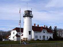
Chatham is home to the Chatham Lighthouse, which was established by President Thomas Jefferson in 1808 to protect the ships circling the Cape. The 1808 towers were replaced in 1841 by twin brick towers that were eventually lost to erosion. The pair were rebuilt in 1877 out of cast iron across the street from its original location, where the light is today. The northern of the two was moved to Eastham to become the Nauset Light in 1923, when the northern tower was declared surplus. Today, the keeper's house is home to a Coast Guard station which patrols the waters of the Atlantic and Nantucket Sound from Wellfleet to West Yarmouth. The first reforesting project in America took place on Great Hill in 1821 when Selectmen had pine trees and beach grass planted to prevent erosion and to keep sand from blowing over the village.[3]
Although urban sprawl has invaded the Cape, the town of Chatham still boasts a quaint and walkable Main Street, home to numerous family-owned and -operated shops, restaurants, and businesses. The main shopping area features pedestrian-friendly crosswalks, on-street parallel parking, and some parking lots that are off Main Street. During the summer, concerts are held in a gazebo on Main Street, and not far from the shops is where the Chatham Anglers baseball team plays, as part of the Cape Cod Baseball League on the peninsula for collegiate-age players.
Chatham, like much of Cape Cod, is suffering from an exodus of young people and young families due to high housing prices and a lack of social and professional opportunities.[4] The majority of homes in Chatham sit empty in the winter months until the summer when second-home owners come to use their summer/vacation homes, or they are used as weekly rentals for tourists.[5][6] As of February 22, 2012, the average listing price for a home in Chatham was $1.3 million.[7]
In summer, Chatham grows to a population of an estimated 30,000. Facilities are overcrowded, and there continues to be limited parking in the Main Street Business District. Beaches are affected by this increase of population. Limited parking exists in established parking areas, and the town's most popular beach, Lighthouse Beach, has only off the street parking, which sometimes involves a long walk to her sandy shores.
Historical sites and museums
- Atwood House (1752)
- Caleb Nickerson House (1772)
- Chatham Railroad Museum (1887)
- Josiah Mayo House (c. 1820)
- Marconi Maritime Museum [1914]
Geography
The town occupies the southeast corner (the "elbow") of Cape Cod. The town's villages include Chatham proper, Chatham Port, North Chatham, West Chatham, and South Chatham (west of West Chatham). Chatham is bordered by Harwich to the west, Pleasant Bay and Orleans to the north, the Atlantic Ocean to the east, and Nantucket Sound to the south. The town is 35 miles (56 km) south of Provincetown and east of the Sagamore Bridge, 20 miles (32 km) east of Barnstable, and 85 miles (137 km) southeast of Boston.
According to the United States Census Bureau, the town has a total area of 24.4 square miles (63.2 km2), of which 16.1 square miles (41.8 km2) is land and 8.3 square miles (21.4 km2), or 33.88%, is water.[2]
The mainland portion of the town is typical of Cape Cod, with several ponds, brooks, rivers, harbors, and inlets around the town. The town includes two narrow strips of land which serve as a barrier between the Atlantic and the mainland; the northern of these is the southern part of the Cape Cod National Seashore. There are several islands, including Strong Island, Tern Island (which is a sanctuary), Morris Island, Stage Island, and Monomoy Island, a 7.25-mile-long (11.67 km) island south of the corner of the town which is home to the Monomoy National Wildlife Refuge. Erosion has changed the region over the years—for example, an island named Slut's Bush once existed until it vanished under water by the mid 19th century.[8]
Climate
Chatham has a warm-summer humid continental climate under the Köppen climate classification (Dfb) bordering an oceanic climate (Cfb), and is located in Hardiness zone 7b.
| Climate data for Cape Cod (Chatham, Massachusetts) | |||||||||||||
|---|---|---|---|---|---|---|---|---|---|---|---|---|---|
| Month | Jan | Feb | Mar | Apr | May | Jun | Jul | Aug | Sep | Oct | Nov | Dec | Year |
| Record high °F (°C) | 61 (16) |
57 (14) |
77 (25) |
81 (27) |
88 (31) |
90 (32) |
95 (35) |
93 (34) |
85 (29) |
82 (28) |
68 (20) |
69 (21) |
95 (35) |
| Average high °F (°C) | 37.6 (3.1) |
38.3 (3.5) |
42.8 (6) |
50.5 (10.3) |
59.0 (15) |
68.4 (20.2) |
74.9 (23.8) |
74.7 (23.7) |
69.4 (20.8) |
60.0 (15.6) |
51.7 (10.9) |
42.8 (6) |
55.9 (13.3) |
| Daily mean °F (°C) | 30.9 (−0.6) |
31.7 (−0.2) |
36.7 (2.6) |
45.1 (7.3) |
53.6 (12) |
62.6 (17) |
68.8 (20.4) |
68.7 (20.4) |
63.6 (17.6) |
53.9 (12.2) |
45.6 (7.6) |
36.5 (2.5) |
49.9 (9.9) |
| Average low °F (°C) | 24.1 (−4.4) |
25.0 (−3.9) |
30.7 (−0.7) |
39.6 (4.2) |
48.1 (8.9) |
56.7 (13.7) |
62.7 (17.1) |
62.6 (17) |
57.7 (14.3) |
47.8 (8.8) |
39.6 (4.2) |
30.2 (−1) |
43.8 (6.6) |
| Record low °F (°C) | −6 (−21) |
−4 (−20) |
7 (−14) |
19 (−7) |
33 (1) |
44 (7) |
51 (11) |
47 (8) |
40 (4) |
31 (−1) |
19 (−7) |
0 (−18) |
−6 (−21) |
| Average precipitation inches (mm) | 3.83 (97.3) |
4.24 (107.7) |
4.85 (123.2) |
4.14 (105.2) |
3.81 (96.8) |
3.41 (86.6) |
3.28 (83.3) |
3.20 (81.3) |
3.83 (97.3) |
4.04 (102.6) |
4.03 (102.4) |
4.38 (111.3) |
47.04 (1,194.8) |
| Average snowfall inches (cm) | 8.2 (20.8) |
10.3 (26.2) |
3.5 (8.9) |
0.6 (1.5) |
0 (0) |
0 (0) |
0 (0) |
0 (0) |
0 (0) |
0 (0) |
0.4 (1) |
3.6 (9.1) |
26.6 (67.6) |
| Average precipitation days (≥ 0.01 in) | 12 | 10 | 12 | 11 | 11 | 9 | 8 | 8 | 9 | 10 | 11 | 13 | 125 |
| Source #1: Western Regional Climate Center (normals 1981–2010, extremes and snow 1972–present)[9] | |||||||||||||
| Source #2: NOAA[10] | |||||||||||||
Transportation
All five roads that exit Chatham cross into Harwich. The two state routes that pass through the town are Route 28 and the southern end of Route 137. Route 28 circles through the center of town before exiting and heading north toward Route 6A, joining that route until the roads end at the Orleans Rotary.
Rail service no longer extends to the town; the former rail bed is a bicycling path, and is called the Old Colony Rail Trail. In addition, another bicycle route passes through the town, starting at the end of the Rail Trail, and providing views of Chatham Fish Pier, Chatham Bars, and Chatham Light.[11]
The town is the home to the Chatham Municipal Airport, which provides local service to other small airports on the Cape and islands. The nearest national and international air service can be reached at Logan International Airport in Boston.
Demographics
| Historical population | ||
|---|---|---|
| Year | Pop. | ±% |
| 1850 | 2,439 | — |
| 1860 | 2,710 | +11.1% |
| 1870 | 2,411 | −11.0% |
| 1880 | 2,250 | −6.7% |
| 1890 | 1,954 | −13.2% |
| 1900 | 1,749 | −10.5% |
| 1910 | 1,564 | −10.6% |
| 1920 | 1,737 | +11.1% |
| 1930 | 1,931 | +11.2% |
| 1940 | 2,136 | +10.6% |
| 1950 | 2,457 | +15.0% |
| 1960 | 3,273 | +33.2% |
| 1970 | 4,554 | +39.1% |
| 1980 | 6,071 | +33.3% |
| 1990 | 6,579 | +8.4% |
| 2000 | 6,625 | +0.7% |
| 2010 | 6,125 | −7.5% |
As of the census[12] of 2000, there were 6,625 people, 3,160 households, and 1,886 families residing in the town. The population density was 408.4 people per square mile (157.7/km²). There were 6,743 housing units at an average density of 415.7 per square mile (160.5/km²). The racial makeup of the town was 96% White, 1.9% Black or African American, 0.2% Native American, 0.3% Asian, <0.1% Pacific Islander, 0.9% from other races, and 0.8% from two or more races. Hispanic or Latino of any race were 1.0% of the population.
During the summer months (generally Memorial Day through Labor Day), the population of the town triples to approximately 20,000, not counting the additional transient tourist population hosted by the town's many hotels, inns, motels, and bed and breakfasts. Tourism and Hospitality along with Commercial Fishing make up the town's main industry. The town has a thriving commercial fish pier where day-boats unload fresh fish and lobster.
There were 3,160 households out of which 15.3% had children under the age of 18 living with them, 51.2% were married couples living together, 6.0% had a female householder with no husband present, and 40.3% were non-families. 34.7% of all households were made up of individuals and 18.8% had someone living alone who was 65 years of age or older. The average household size was 2.00 and the average family size was 2.52.
In the town, the population was spread out with 13.3% under the age of 18, 4.4% from 18 to 24, 19.8% from 25 to 44, 28.2% from 45 to 64, and 34.3% who were 65 years of age or older. The median age was 54 years. For every 100 females, there were 89.3 males. For every 100 females age 18 and over, there were 85.4 males.
The local K-12 school system has approximately 700 students, making for average high school grade sizes between 30 and 40 students.
The median income for a household in the town was $85,519, and the median income for a family was $112,750. Males had a median income of $71,064 versus $40,365 for females. The per capita income for the town was $48,594. About 1.9% of families and 4.8% of the population were below the poverty line, including 5.1% of those under age 18 and 3.7% of those age 65 or over.
Government
Chatham is represented in the Massachusetts House of Representatives as a part of the Fourth Barnstable district, which includes (with the exception of Brewster) all the towns east and north of Harwich on the Cape. The town is represented in the Massachusetts Senate as a part of the Cape and Islands District, which includes all of Cape Cod, Martha's Vineyard, and Nantucket except the towns of Bourne, Falmouth, Sandwich, and a portion of Barnstable.[13]
The Chatham Police Department is the primary law enforcement agency that services the town. The Police Department is staffed for 24-hour patrol and is a member of the Cape Cod Regional Law Enforcement Council. The Police station was recently constructed in 2012, and is located on George Ryder Road, across the street from the Chatham Municipal Airport. Troopers from the Massachusetts State Police Troop D Yarmouth barracks provide secondary law enforcement services to the town.
The Chatham Fire/Rescue Department is a 24-hour, fully staffed fire department, that provides fire and medical services to the town. The new fire station was constructed in 2016, and is located on Depot Road, across the street from Veteran’s Field. Prior to 2012, the fire and police stations were attached and sat on the Depot Road site. The Chatham Fire/Rescue Department also has an unmanned substation on Route 28 in South Chatham; this station houses one engine truck.
On the national level, Chatham is a part of Massachusetts's 9th congressional district and is represented by William R. Keating. The state's senior (Class II) member of the United States Senate, elected in 2012, is Elizabeth Warren. The junior (Class I) senator is Ed Markey.
Chatham is governed by the open town meeting form of government, administered by an elected Board of Selectmen and an appointed Town Manager. The town has four post offices, all located at various points along Route 28. The town is home to the Eldredge Public Library, named for its benefactor and designed by a student of H. H. Richardson. The town operates several piers, beaches, boat landings and recreation areas throughout town. The nearest hospital is Cape Cod Hospital in Hyannis.
Education
Until 2013, Chatham operated its own school system for the town's 700 students. The Chatham Elementary School served students from pre-kindergarten through fourth grade, the Chatham Middle School served students from fifth through eighth grade, and Chatham High School served grades nine through twelve. Chatham's athletics teams were known as the Blue Devils, and wore blue and white. In December 2010, Chatham and the neighboring town of Harwich voted to regionalize their school systems into the Monomoy Regional school system. The Monomoy teams are known as the Sharks and their colors are navy blue and sliver. In March 2013, construction began in Harwich on a new high school to serve the region, expected to open in 2014. High school students may attend Cape Cod Regional Technical School in Harwich free of charge. Other private schools are located in nearby Brewster and Harwich.
Notable people
- Zered Bassett, pro skateboarder, grew up in Chatham
- Shirley Booth, actress
- Ruby Braff, musician, died in Chatham
- Louis Brandeis, Supreme Court Justice
- Harry Connick, Jr., actor and singer
- Bernard Cornwell, best-selling author
- Franklin Cover, late actor
- David Drumm, former CEO of Anglo Irish Bank[14]
- Todd Eldredge, champion figure skater
- Jack Forrester, Scottish-American professional golfer[15]
- Lisa Genova, best-selling author
- Bobby Hackett, musician
- Julie Harris, actress
- Gilbert Knapp, Wisconsin State Assemblyman
- Joseph C. Lincoln, author of Cape Cod Stories
- Joseph Lord, Puritan pastor
- Sandra Day O'Connor, Supreme Court justice; has a residence in Chatham
- Sara Pennypacker, children's book author
- Bill Richardson, American politician, author, and diplomat[16]
- Christopher Seufert, film director/photographer
- Archelaus Smith, Nova Scotia pioneer
- Bob Staake, cartoonist & illustrator
- Tisquantum (Squanto), died in Chatham and is buried in an unmarked grave on Burial Hill, overlooking Ryder's Cove
- Bernard C. Webber, heroic Coast Guardsman who was award the Gold Lifesaving Medal for leading a rescue to the SS Pendleton in 1952
Gallery
 The Atwood House
 Chatham Lights
 Stage Harbor Light
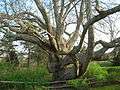 Old Linden Tree (April 2012)
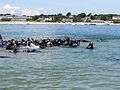 Seals in Chatham Harbor
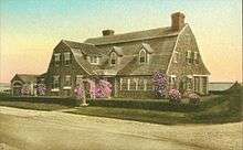 Cross Trees
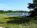
References
- 1 2 3 4 5 Smith, William C. (1909). A history of Chatham, Massachusetts; formerly the Constablewick or Village of Monomoit; with maps and illustrations and numerous genealogical notes. Hyannis, MA: F.B. & F.P. Goss. OL 14012476M. Retrieved 2013-10-13.
- 1 2 "Geographic Identifiers: 2010 Demographic Profile Data (G001): Chatham town, Barnstable County, Massachusetts". U.S. Census Bureau, American Factfinder. Retrieved December 4, 2013.
- ↑ Green, Eugene; Sachse, William; McCaulley, Brian (2006). The Names of Cape Cod. Arcadia Press. p. 96. ISBN 978-1-933212-84-5.
- ↑ "WCAI | How We've Grown". Wgbh.org. Retrieved 2013-01-04.
- ↑ "WCAI | Two Cape Cods: Hidden Poverty on the Cape and Islands". Wgbh.org. Archived from the original on 2013-04-09. Retrieved 2013-01-04.
- ↑ Holson, Laura M. (March 5, 2009). "In Winter, Cape Cod Vacations are Quiet and Peaceful". The New York Times.
- ↑ "Chatham, MA real estate overview". Trulia.com. Retrieved 2013-01-04.
- ↑ The New England historical and genealogical register, Volume 18. https://books.google.com/books?id=TTkONJrQrtYC&pg=PA43&lpg=PA43
- ↑ "General Climate Summary Tables". Western Regional Climate Center. Retrieved February 19, 2013.
- ↑ "NowData - NOAA Online Weather Data". National Oceanic and Atmospheric Administration. Retrieved February 19, 2015.
- ↑ "Chatham Bike Routes". Cape Cod Bike Book.
- ↑ "American FactFinder". United States Census Bureau. Archived from the original on 2013-09-11. Retrieved 2008-01-31.
- ↑ Index of Legislative Representation by City and Town, from Mass.gov
- ↑ Beth Healy; Casey Ross (April 12, 2010). "Irish bank's ex-CEO sits out crisis on Cape". The Boston Globe. Boston. 277 (102).
- ↑ "Jack Forrester (1894-1964)". NorthBerwick.org.uk.
- ↑ "New Mexico's Richardson buys Cape home". CapeCodTimes.com.
External links
| Wikimedia Commons has media related to Chatham, Massachusetts. |
| Wikivoyage has a travel guide for Chatham (Massachusetts). |