Châteaugiron
| Châteaugiron Kastell-Geron | ||
|---|---|---|
| Commune | ||
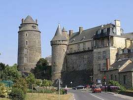 Chateau | ||
| ||
 Châteaugiron Location within Brittany region  Châteaugiron | ||
| Coordinates: 48°02′56″N 1°30′07″W / 48.0489°N 1.5019°WCoordinates: 48°02′56″N 1°30′07″W / 48.0489°N 1.5019°W | ||
| Country | France | |
| Region | Brittany | |
| Department | Ille-et-Vilaine | |
| Arrondissement | Rennes | |
| Canton | Châteaugiron | |
| Intercommunality | Pays de Châteaugiron | |
| Government | ||
| • Mayor (2014–2020) | Françoise Gatel | |
| Area1 | 23.52 km2 (9.08 sq mi) | |
| Population (2014)2 | 9,434 | |
| • Density | 400/km2 (1,000/sq mi) | |
| Time zone | UTC+1 (CET) | |
| • Summer (DST) | UTC+2 (CEST) | |
| INSEE/Postal code | 35069 /35410 | |
| Elevation | 28–78 m (92–256 ft) | |
|
1 French Land Register data, which excludes lakes, ponds, glaciers > 1 km2 (0.386 sq mi or 247 acres) and river estuaries. 2 Population without double counting: residents of multiple communes (e.g., students and military personnel) only counted once. | ||
.svg.png)
Châteaugiron (Breton: Kastell-Geron, Gallo: Chaujon) is a commune in the Ille-et-Vilaine department of Brittany in northwestern France. It extended on 1 January 2017 by merging with the former communes of Saint-Aubin-du-Pavail and Ossé.[1]
Population
Inhabitants of Châteaugiron are called Castelgironnais in French.
| Historical population | ||
|---|---|---|
| Year | Pop. | ±% |
| 1962 | 1,682 | — |
| 1968 | 2,060 | +22.5% |
| 1975 | 2,330 | +13.1% |
| 1982 | 3,244 | +39.2% |
| 1990 | 4,166 | +28.4% |
| 1999 | 5,500 | +32.0% |
| 2008 | 6,450 | +17.3% |
Sister cities

Gallery
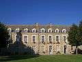 Town hall
See also
References
- ↑ (in French) Arrêté du 13 juin 2016 portant création de la commune nouvelle de Châteaugiron
- ↑ "Les jumelages". Chateaugiron. Retrieved 2 June 2014.
- Mayors of Ille-et-Vilaine Association (in French)
External links
| Wikimedia Commons has media related to Châteaugiron. |
- Official website (in French)
- French Ministry of Culture list for Châteaugiron (in French)
This article is issued from
Wikipedia.
The text is licensed under Creative Commons - Attribution - Sharealike.
Additional terms may apply for the media files.