Arrondissement of Rennes
| Rennes | |
|---|---|
| Arrondissement | |
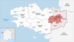 Location of Rennes in Brittany | |
| Country | France |
| Region | Brittany |
| Department | Ille-et-Vilaine |
| Communes | 111 |
| Prefecture | Rennes |
| Area¹ | |
| • Total | 2,228 km2 (860 sq mi) |
| Population (2013) | |
| • Total | 581,647 |
| • Density | 260/km2 (680/sq mi) |
| ¹ French Land Register data, which exclude lakes, ponds, and glaciers larger than 1 km² as well as the estuaries of rivers. | |
The arrondissement of Rennes is an arrondissement of France in the Ille-et-Vilaine department in the Brittany region. In 2010 it lost the six cantons of Argentré-du-Plessis, Châteaubourg, La Guerche-de-Bretagne, Retiers, Vitré-Est and Vitré-Ouest to the arrondissement of Fougères-Vitré.[1] Since the January 2017 reorganization of the arrondissements of Ille-et-Vilaine, it has 111 communes.[2]
Composition
Cantons
The cantons of the arrondissement of Rennes are:
- Antrain (partly)
- Betton
- Bruz
- Châteaugiron (partly)
- Combourg (partly)
- Fougères-1 (partly)
- Janzé (partly)
- Liffré
- Melesse (partly)
- Montauban-de-Bretagne
- Montfort-sur-Meu
- Rennes-1
- Rennes-2
- Rennes-3
- Rennes-4
- Rennes-5
- Rennes-6
- Le Rheu
Communes
The communes of the arrondissement of Rennes, and their INSEE codes, are:
- Acigné (35001)
- Andouillé-Neuville (35003)
- Aubigné (35007)
- Bécherel (35022)
- Bédée (35023)
- Betton (35024)
- Bléruais (35026)
- Boisgervilly (35027)
- La Bouëxière (35031)
- Bourgbarré (35032)
- Bréal-sous-Montfort (35037)
- Brécé (35039)
- Breteil (35040)
- Bruz (35047)
- Cesson-Sévigné (35051)
- Chancé (35053)
- Chantepie (35055)
- La Chapelle-Chaussée (35058)
- La Chapelle-des-Fougeretz (35059)
- La Chapelle-du-Lou-du-Lac (35060)
- La Chapelle-Thouarault (35065)
- Chartres-de-Bretagne (35066)
- Chasné-sur-Illet (35067)
- Châteaugiron (35069)
- Chavagne (35076)
- Chevaigné (35079)
- Cintré (35080)
- Clayes (35081)
- Corps-Nuds (35088)
- Le Crouais (35091)
- Domloup (35099)
- Dourdain (35101)
- Ercé-près-Liffré (35107)
- Feins (35110)
- Gaël (35117)
- Gahard (35118)
- Gévezé (35120)
- Gosné (35121)
- Guipel (35128)
- L'Hermitage (35131)
- Iffendic (35133)
- Irodouër (35135)
- Laillé (35139)
- Landujan (35143)
- Langan (35144)
- Langouet (35146)
- Liffré (35152)
- Livré-sur-Changeon (35154)
- Maxent (35169)
- Médréac (35171)
- Melesse (35173)
- La Mézière (35177)
- Mézières-sur-Couesnon (35178)
- Miniac-sous-Bécherel (35180)
- Montauban-de-Bretagne (35184)
- Monterfil (35187)
- Montfort-sur-Meu (35188)
- Montgermont (35189)
- Montreuil-le-Gast (35193)
- Montreuil-sur-Ille (35195)
- Mordelles (35196)
- Mouazé (35197)
- Muel (35201)
- La Nouaye (35203)
- Nouvoitou (35204)
- Noyal-Châtillon-sur-Seiche (35206)
- Noyal-sur-Vilaine (35207)
- Orgères (35208)
- Pacé (35210)
- Paimpont (35211)
- Parthenay-de-Bretagne (35216)
- Piré-sur-Seiche (35220)
- Plélan-le-Grand (35223)
- Pleumeleuc (35227)
- Pont-Péan (35363)
- Quédillac (35234)
- Rennes (35238)
- Le Rheu (35240)
- Romillé (35245)
- Saint-Armel (35250)
- Saint-Aubin-d'Aubigné (35251)
- Saint-Aubin-du-Cormier (35253)
- Saint-Erblon (35266)
- Saint-Germain-sur-Ille (35274)
- Saint-Gilles (35275)
- Saint-Gondran (35276)
- Saint-Gonlay (35277)
- Saint-Grégoire (35278)
- Saint-Jacques-de-la-Lande (35281)
- Saint-Malon-sur-Mel (35290)
- Saint-Maugan (35295)
- Saint-Médard-sur-Ille (35296)
- Saint-Méen-le-Grand (35297)
- Saint-M'Hervon (35301)
- Saint-Onen-la-Chapelle (35302)
- Saint-Péran (35305)
- Saint-Pern (35307)
- Saint-Sulpice-la-Forêt (35315)
- Saint-Symphorien (35317)
- Saint-Thurial (35319)
- Saint-Uniac (35320)
- Sens-de-Bretagne (35326)
- Servon-sur-Vilaine (35327)
- Talensac (35331)
- Thorigné-Fouillard (35334)
- Treffendel (35340)
- Le Verger (35351)
- Vern-sur-Seiche (35352)
- Vezin-le-Coquet (35353)
- Vieux-Vy-sur-Couesnon (35355)
- Vignoc (35356)
References
- ↑ INSEE, Modifications territoriales
- ↑ "Arrondisements d'Ille-et-Vilaine au 1er janvier 2017" (PDF). Retrieved 2017-08-04.
External links
This article is issued from
Wikipedia.
The text is licensed under Creative Commons - Attribution - Sharealike.
Additional terms may apply for the media files.