Lieuron
| Lieuron Luzron | |
|---|---|
| Commune | |
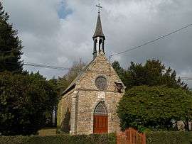 The chapel of Notre-Dame-des-Sept-Douleurs, in Lieuron | |
 Lieuron Location within Brittany region  Lieuron | |
| Coordinates: 47°51′07″N 1°56′36″W / 47.8519°N 1.9433°WCoordinates: 47°51′07″N 1°56′36″W / 47.8519°N 1.9433°W | |
| Country | France |
| Region | Brittany |
| Department | Ille-et-Vilaine |
| Arrondissement | Redon |
| Canton | Redon |
| Intercommunality | Canton of Pipriac |
| Government | |
| • Mayor (2014–2020) | Rose-Line Prévert |
| Area1 | 16.72 km2 (6.46 sq mi) |
| Population (2008)2 | 716 |
| • Density | 43/km2 (110/sq mi) |
| Time zone | UTC+1 (CET) |
| • Summer (DST) | UTC+2 (CEST) |
| INSEE/Postal code | 35151 /35550 |
| Elevation | 18–69 m (59–226 ft) |
|
1 French Land Register data, which excludes lakes, ponds, glaciers > 1 km2 (0.386 sq mi or 247 acres) and river estuaries. 2 Population without double counting: residents of multiple communes (e.g., students and military personnel) only counted once. | |
Lieuron (Breton: Luzron) is a commune in the Ille-et-Vilaine department in Brittany in northwestern France.
Population
Inhabitants of Lieuron are called Lieuronnais in French.
| Historical population | ||
|---|---|---|
| Year | Pop. | ±% |
| 1962 | 502 | — |
| 1968 | 555 | +10.6% |
| 1975 | 561 | +1.1% |
| 1982 | 526 | −6.2% |
| 1990 | 505 | −4.0% |
| 1999 | 560 | +10.9% |
| 2008 | 716 | +27.9% |
| 2012 | 769 | +7.4% |
See also
References
- Mayors of Ille-et-Vilaine Association (in French)
External links
| Wikimedia Commons has media related to Lieuron. |
- French Ministry of Culture list for Lieuron (in French)
This article is issued from
Wikipedia.
The text is licensed under Creative Commons - Attribution - Sharealike.
Additional terms may apply for the media files.