Teillay
| Teillay Tilheg | ||
|---|---|---|
| Commune | ||
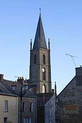 The church of Notre-Dame-de-l'Assomption | ||
| ||
 Teillay Location within Brittany region  Teillay | ||
| Coordinates: 47°48′29″N 1°32′13″W / 47.8081°N 1.5369°WCoordinates: 47°48′29″N 1°32′13″W / 47.8081°N 1.5369°W | ||
| Country | France | |
| Region | Brittany | |
| Department | Ille-et-Vilaine | |
| Arrondissement | Redon | |
| Canton | Bain-de-Bretagne | |
| Intercommunality | Moyenne Vilaine et du Semnon | |
| Government | ||
| • Mayor (2014–2020) | Yvon Mellet | |
| Area1 | 26.21 km2 (10.12 sq mi) | |
| Population (2009)2 | 970 | |
| • Density | 37/km2 (96/sq mi) | |
| Time zone | UTC+1 (CET) | |
| • Summer (DST) | UTC+2 (CEST) | |
| INSEE/Postal code | 35332 /35620 | |
| Elevation | 37–98 m (121–322 ft) | |
|
1 French Land Register data, which excludes lakes, ponds, glaciers > 1 km2 (0.386 sq mi or 247 acres) and river estuaries. 2 Population without double counting: residents of multiple communes (e.g., students and military personnel) only counted once. | ||
.svg.png)
Teillay (Breton: Tilheg) is a commune in the Ille-et-Vilaine department in Brittany in northwestern France.
Geography
The Brutz forms all of the commune's eastern border, then flows into the Semnon, which forms part of its northeastern border.
Population
Inhabitants of Teillay are called Teillacois in French.
| Historical population | ||
|---|---|---|
| Year | Pop. | ±% |
| 1962 | 1,009 | — |
| 1968 | 1,066 | +5.6% |
| 1975 | 948 | −11.1% |
| 1982 | 829 | −12.6% |
| 1990 | 786 | −5.2% |
| 1999 | 786 | +0.0% |
| 2009 | 970 | +23.4% |
See also
References
- Mayors of Ille-et-Vilaine Association (in French)
External links
| Wikimedia Commons has media related to Teillay. |
- French Ministry of Culture list for Teillay (in French)
This article is issued from
Wikipedia.
The text is licensed under Creative Commons - Attribution - Sharealike.
Additional terms may apply for the media files.