Canal Street (IND Eighth Avenue Line)
Canal Street | |||||||||||
|---|---|---|---|---|---|---|---|---|---|---|---|
|
| |||||||||||
 | |||||||||||
| Station statistics | |||||||||||
| Address |
Canal Street & Sixth Avenue New York, NY 10013 | ||||||||||
| Borough | Manhattan | ||||||||||
| Locale | Tribeca, SoHo | ||||||||||
| Coordinates | 40°43′19″N 74°00′19″W / 40.72186°N 74.005365°WCoordinates: 40°43′19″N 74°00′19″W / 40.72186°N 74.005365°W | ||||||||||
| Division | B (IND) | ||||||||||
| Line | IND Eighth Avenue Line | ||||||||||
| Services |
A C E | ||||||||||
| Transit connections |
| ||||||||||
| Structure | Underground | ||||||||||
| Platforms |
2 island platforms cross-platform interchange | ||||||||||
| Tracks | 4 | ||||||||||
| Other information | |||||||||||
| Opened | September 10, 1932.[1] | ||||||||||
| Station code | 169[2] | ||||||||||
| Accessibility | Cross-platform wheelchair transfer available | ||||||||||
| Wireless service |
| ||||||||||
| Former/other names | Canal Street–Holland Tunnel | ||||||||||
| Traffic | |||||||||||
| Passengers (2017) |
5,932,386[4] | ||||||||||
| Rank | 75 out of 425 | ||||||||||
| Station succession | |||||||||||
| Next north |
West Fourth Street–Washington Square (express): A Spring Street (local): A | ||||||||||
| Next south |
World Trade Center (local): E Chambers Street (express): A | ||||||||||
| |||||||||||
| |||||||||||
| |||||||||||


Canal Street (formerly Canal Street–Holland Tunnel) is an express station on the IND Eighth Avenue Line of the New York City Subway. Located at the intersection of Canal Street, Vestry Street, and Sixth Avenue (Avenue of the Americas) in Lower Manhattan, it is served by the A and E trains at all times, and the C train at all times except late nights.
History
This station opened on September 10, 1932 as part of the opening of the first city-owned subway line, the IND Eighth Avenue Line. On this date, the line opened from Chambers Street north to 207th Street. Construction of the whole line cost $191,200,000. Service at this station was provided with express service from is onset.[1]
On February 17, 1953, the Board of Transportation installed two devices at either end of the station to alert police of passers-by above of emergencies in the station. The devices, which cost $1,100, were called "Call-a-Cop." In the station agent booth, an agent could set off an alarm bell and turn on a red warning light aboveground at Canal and Walker Streets on Sixth Avenue by lightly pushing on a treadle. The warning lights were placed atop eight-feet tall metal poles located at subway entrances. This device would have been installed at other stations if the pilot here was successful.[5]
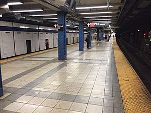
Station layout
| G | Street Level | Exit/ Entrance |
| M | Mezzanine | Fare control, station agent |
| P Platforms |
Northbound local | ← |
| Island platform, doors will open on the left, right | ||
| Northbound express | ← ← | |
| Southbound express | → | |
| Island platform, doors will open on the left, right | ||
| Southbound local | → → | |
This station has four tracks and two island platforms, which are each approximately 660 feet (200 m) long. There are two diamond crossovers allowing express trains to cross to the local track or local trains to cross to the express track. One is located to the south of the station for downtown (southbound) trains and the other is located to the north of the station for uptown (northbound) trains; this can be a bottleneck for trains in either direction. The platforms are offset, and a signal tower is located at the south end of the southbound platform.[6]
This underground station is located on the street of the same name, which is the boundary of SoHo and Tribeca. Lying within a block of three different pocket parks (St. John's Park, Duane Park, and Cavala Park), the station sits one block from the entrance to the Holland Tunnel outside of the Tribeca North Historic District.[7] Much of the surrounding area is characterized by its historic loft architecture.
Track layout
South of this station, the tracks split into two levels and cross at a flying junction.[6] These were intended to allow for the construction of a future junction with a proposed line under Worth Street as part of the IND Second System. The proposed route would have run under Worth Street and East Broadway, and crossed the East River to Brooklyn. The bellmouths for this proposed route are visible from the E train headed towards and coming from the World Trade Center station. On the tunnel wall where the turnout is, there is an arrow painted with the words reading: "Worth St." written next to it.[8]
Exits
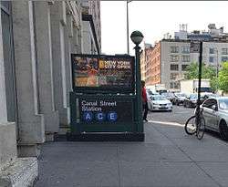
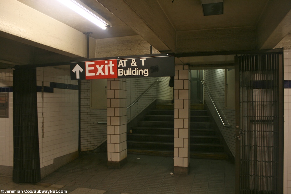
The Canal Street station contains five exits. Only one exit is located at the station's namesake–Canal Street–at the northeast corner of Sixth Avenue and Canal Street. The other exit leading from the northern section of the station leads to the south side of Laight Street, between Sixth Avenue and St. Johns Lane. At the center of the station there are exits to the northwest and northeast corners of Sixth Avenue and West Broadway. At the southern end of the station there are two exits. One exit leads to the northeast corner of Sixth Avenue and Walker Street, while the other leads to the AT&T Building.[9][10]
References
- 1 2 Crowell, Paul (September 10, 1932). "Gay Midnight Crowd Rides First Trains In The New Subway: Throngs at Station an Hour Before Time, Rush Turnstiles When Chains are Dropped" (PDF). New York Times. Retrieved November 8, 2015.
- ↑ "Station Developers' Information". Metropolitan Transportation Authority. Retrieved June 13, 2017.
- ↑ "NYC Subway Wireless – Active Stations". Transit Wireless Wifi. Retrieved May 18, 2016.
- ↑ "Facts and Figures: Annual Subway Ridership 2012–2017". Metropolitan Transportation Authority. July 12, 2018. Retrieved July 12, 2018.
- ↑ "CALL-A-COP' SHOWN; Device in IND Subway Station Alerts Police in Street". The New York Times. February 18, 1953. ISSN 0362-4331. Retrieved April 2, 2018.
- 1 2 Dougherty, Peter (2006) [2002]. Tracks of the New York City Subway 2006 (3rd ed.). Dougherty. OCLC 49777633 – via Google Books.
- ↑ "Tribeca North Historic District" (PDF). New York City Landmarks Commission. Retrieved July 10, 2011.
- ↑ https://www.youtube.com/watch?v=r8NAOtBXKhA A bellmouth is visible to the left, at the 4:12 mark into this video, just before the train enters the World Trade Center station.
- ↑ "MTA Neighborhood Maps: SoHo / Tribeca" (PDF). Metropolitan Transportation Authority. 2015. Retrieved August 6, 2015.
- ↑ Cox, Jeremiah (May 24, 2010). "The pillars on the sides of the staircase to the AT&T Building". subwaynut.com. Retrieved April 2, 2018.
External links
| Wikimedia Commons has media related to Canal Street (IND Eighth Avenue Line). |
- nycsubway.org – IND 8th Avenue: Canal Street–Holland Tunnel
- nycsubway.org — A Gathering Artwork by Martin & Munoz (unknown date)
- Station Reporter — A Lefferts
- Station Reporter — A Rockaway
- Station Reporter — C Train
- Station Reporter — E Train
- MTA's Arts For Transit — Canal Street (IND Eighth Avenue Line)
- Canal Street entrance from Google Maps Street View
- Laight Street entrance from Google Maps Street View
- West Broadway entrance from Google Maps Street View
- Beach Street — Walker Street entrance from Google Maps Street View
- Platforms from Google Maps Street View
| Eighth Avenue Line |
|
|---|---|
| |