111th Street (IND Fulton Street Line)
111 Street | |||||||
|---|---|---|---|---|---|---|---|
|
| |||||||
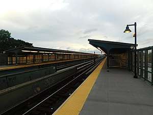 111th Street station in June 2018 | |||||||
| Station statistics | |||||||
| Address |
111th Street & Liberty Avenue Queens, NY 11419 | ||||||
| Borough | Queens | ||||||
| Locale | Richmond Hill | ||||||
| Coordinates | 40°41′05″N 73°49′52″W / 40.684673°N 73.831129°WCoordinates: 40°41′05″N 73°49′52″W / 40.684673°N 73.831129°W | ||||||
| Division | B (IND, formerly BMT) | ||||||
| Line |
IND Fulton Street Line BMT Fulton Street Line (formerly) | ||||||
| Services |
A | ||||||
| Transit connections |
| ||||||
| Structure | Elevated | ||||||
| Platforms | 2 side platforms | ||||||
| Tracks | 3 (2 in regular service) | ||||||
| Other information | |||||||
| Opened | September 25, 1915[1] | ||||||
| Station code | 194[2] | ||||||
| Former/other names | 111th Street–Greenwood Avenue | ||||||
| Traffic | |||||||
| Passengers (2017) |
748,813[3] | ||||||
| Rank | 385 out of 425 | ||||||
| Station succession | |||||||
| Next west |
104th Street: A | ||||||
| Next east |
Ozone Park–Lefferts Boulevard: A | ||||||
| |||||||
| |||||||
| |||||||


111th Street is a station on the IND Fulton Street Line of the New York City Subway, located on Liberty Avenue at 111th Street in Richmond Hill, Queens. The station is served by the A train at all times.
History
111th Street was one of the six stations along Liberty Avenue in Queens, from 80th Street through Ozone Park–Lefferts Boulevard, as well as the current three track elevated structure, built for the BMT Fulton Street Line in 1915 as part of BMT's portion of the Dual Contracts.[1][4] The connection to the BMT was severed on April 26, 1956, and the IND was extended east (railroad south) from Euclid Avenue via a connecting tunnel and new intermediate station at Grant Avenue, with the new service beginning on April 29, 1956.[4][5][6] The Fulton Street Elevated west of Hudson Street was closed, and eventually demolished.
The station has gone by a number of different names. It opened as Greenwood Avenue.[1] A 1924 system map portrayed the station as "Greenwood Avenue" with "111th St." below it in parentheses and smaller print.[7] By 1948, "Greenwood" and "111 St." were shown in equal sizes,[8] and by 1959, the station's name was shown as "111 St–Greenwood".[9] The current official map shows the name as just "111 St".[10] However, station signs still show "111th Street–Greenwood Avenue".[11]
The Queens-bound platform was completely renovated in 2015 and reopened on December 12. The Brooklyn-bound platform was completely rehabilitated and reopened in Spring 2016.[12][13]
Station layout
| P Platform level |
Side platform, doors will open on the right | |
| Northbound | ← ← | |
| Peak-direction Express | → No regular service | |
| Southbound | → | |
| Side platform, doors will open on the right | ||
| M | Mezzanine | Fare control, station agent |
| G | Street Level | Exit/ Entrance |
This elevated station, opened on September 25, 1915,[1] has three tracks and two side platforms with the middle track not used in revenue service.[14] Both platforms have beige windscreens for the entire length and brown canopies with green frames and support columns except for a small section at either ends.[11]
Exits
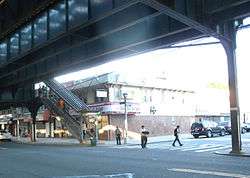
This station has two entrances/exits, both of which are elevated station houses beneath the tracks. The full-time side is at the east (railroad south) end. It has one staircase to each platform, a waiting area that allows a free transfer between directions, a turnstile bank, a token booth, and two staircases down to either eastern corners of Liberty Avenue and 111th Street. The other station house also has one staircase to each platform, waiting area, and two staircases to 109th Street and Liberty Avenue (one to the southeast corner and another along the north side of Liberty Avenue). However, this entrance/exit is unstaffed, containing just High Entry/Exit and Exit-Only turnstiles.[11][14][15][16]
References
- 1 2 3 4 "New Elevated Line Opened for Queens" (PDF). The New York Times. September 26, 1915. Retrieved September 28, 2007.
- ↑ "Station Developers' Information". Metropolitan Transportation Authority. Retrieved June 13, 2017.
- ↑ "Facts and Figures: Annual Subway Ridership 2012–2017". Metropolitan Transportation Authority. July 12, 2018. Retrieved July 12, 2018.
- 1 2 Sparberg, Andrew J. (October 1, 2014). From a Nickel to a Token: The Journey from Board of Transportation to MTA. Fordham University Press. ISBN 978-0-8232-6190-1.
- ↑ "First Leg of Rockaways Transit Opened at Cost of $10,154,702" (PDF). nytimes.com. The New York Times. April 30, 1956. Retrieved June 29, 2015.
- ↑ Freeman, Ira Henry (June 28, 1956). "Rockaway Trains to Operate Today" (PDF). nytimes.com. The New York Times. Retrieved June 29, 2015.
- ↑ "BMT Lines, Rapid Transit Division". 1924. Archived from the original (GIF) on October 12, 2007. Retrieved November 9, 2007.
- ↑ "Rapid Transit Lines of the New York City Transit System". 1948. Archived from the original (GIF) on October 12, 2007. Retrieved November 9, 2007.
- ↑ "Official New York City Subway Map and Station Guide". 1959. Archived from the original (GIF) on October 12, 2007. Retrieved November 9, 2007.
- ↑ "Subway Map" (PDF). Metropolitan Transportation Authority. January 18, 2018. Retrieved January 18, 2018.
- 1 2 3 Cox, Jeremiah. "111 St-Greenwood Avenue (A except Late Nights, S-Late Night Shuttle to Lefferts Blvd) - The SubwayNut". www.subwaynut.com. Retrieved February 18, 2016.
- ↑ "mta.info | Planned Service Changes". web.mta.info. Retrieved February 18, 2016.
- ↑ "MTA | Press Release | NYC Transit | Brooklyn-bound 111 St and 80 St A Line Stations To Close for Three Months for Renewal". www.mta.info. Retrieved February 18, 2016.
- 1 2 "A Lefferts". October 30, 2013. Archived from the original on October 30, 2013. Retrieved February 18, 2016.
- ↑ "www.nycsubway.org: IND Fulton Street Line". www.nycsubway.org. Retrieved February 18, 2016.
- ↑ "MTA Neighborhood Maps: Ozone Park" (PDF). Metropolitan Transportation Authority. 2015. Retrieved 16 October 2015.
External links

- 111th Street entrance from Google Maps Street View
- 109th Street entrance from Google Maps Street View
- Platforms from Google Maps Street View
| Fulton St. Line |
|
|---|---|
| |