Spring Street (IND Eighth Avenue Line)
Spring Street | |||||||||||
|---|---|---|---|---|---|---|---|---|---|---|---|
|
| |||||||||||
 | |||||||||||
| Station statistics | |||||||||||
| Address |
Spring Street & Sixth Avenue New York, NY 10013 | ||||||||||
| Borough | Manhattan | ||||||||||
| Locale | Hudson Square, SoHo | ||||||||||
| Coordinates | 40°43′32″N 74°00′15″W / 40.725503°N 74.004035°WCoordinates: 40°43′32″N 74°00′15″W / 40.725503°N 74.004035°W | ||||||||||
| Division | B (IND) | ||||||||||
| Line | IND Eighth Avenue Line | ||||||||||
| Services |
A C E | ||||||||||
| Transit connections |
| ||||||||||
| Structure | Underground | ||||||||||
| Platforms | 2 side platforms | ||||||||||
| Tracks | 4 | ||||||||||
| Other information | |||||||||||
| Opened | September 10, 1932[1] | ||||||||||
| Station code | 168[2] | ||||||||||
| Wireless service |
| ||||||||||
| Traffic | |||||||||||
| Passengers (2017) |
3,637,863[4] | ||||||||||
| Rank | 140 out of 425 | ||||||||||
| Station succession | |||||||||||
| Next north |
West Fourth Street–Washington Square: A | ||||||||||
| Next south |
Canal Street: A | ||||||||||
| |||||||||||
| |||||||||||
| |||||||||||


Spring Street is a local station on the IND Eighth Avenue Line of the New York City Subway. Located at Spring Street and Sixth Avenue (Avenue of the Americas) in the Hudson Square and SoHo neighborhoods of lower Manhattan, it is served by the C and E trains, the former of which is replaced by the A train during late nights.
History
Spring Street opened on September 10, 1932, as part of the original operating segment of the Independent Subway System (IND) from Chambers Street to Inwood–207th Street.[1][5] Extensions southward in 1933 and 1936 brought direct access to Brooklyn on the IND Fulton Street Line, while service from Spring Street to Queens became possible with the opening of the IND Queens Boulevard Line on August 19, 1933 to Jackson Heights.[6]
The station was renovated as part of the 2010–2014 MTA Capital Program. An MTA study conducted in 2014 found that 31% of station components were out of date.[7]
Station layout
| G | Street Level | Exit/Entrance |
| B1 Platform level |
Side platform, doors will open on the right | |
| Northbound local | ← ← | |
| Northbound express | ← | |
| Southbound express | → | |
| Southbound local | → → | |
| Side platform, doors will open on the right | ||
| B2 | - | Crossunder between platforms |

Like most local subway stations, Spring Street has two side platforms and four tracks. The two center express tracks are used by the A train during daytime hours. A crossunder just within fare control allows a free transfer between directions.
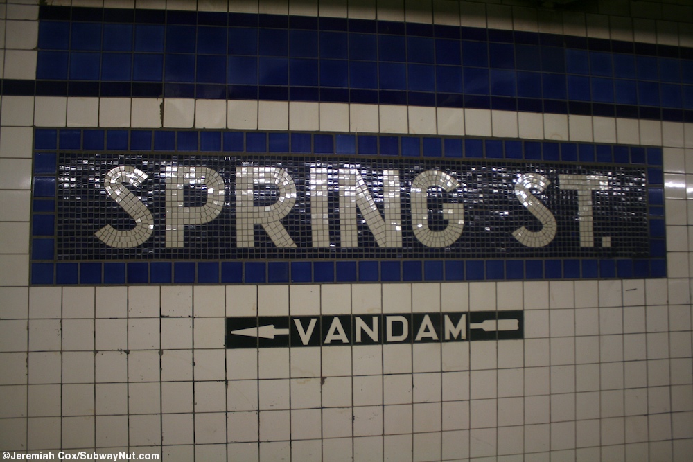
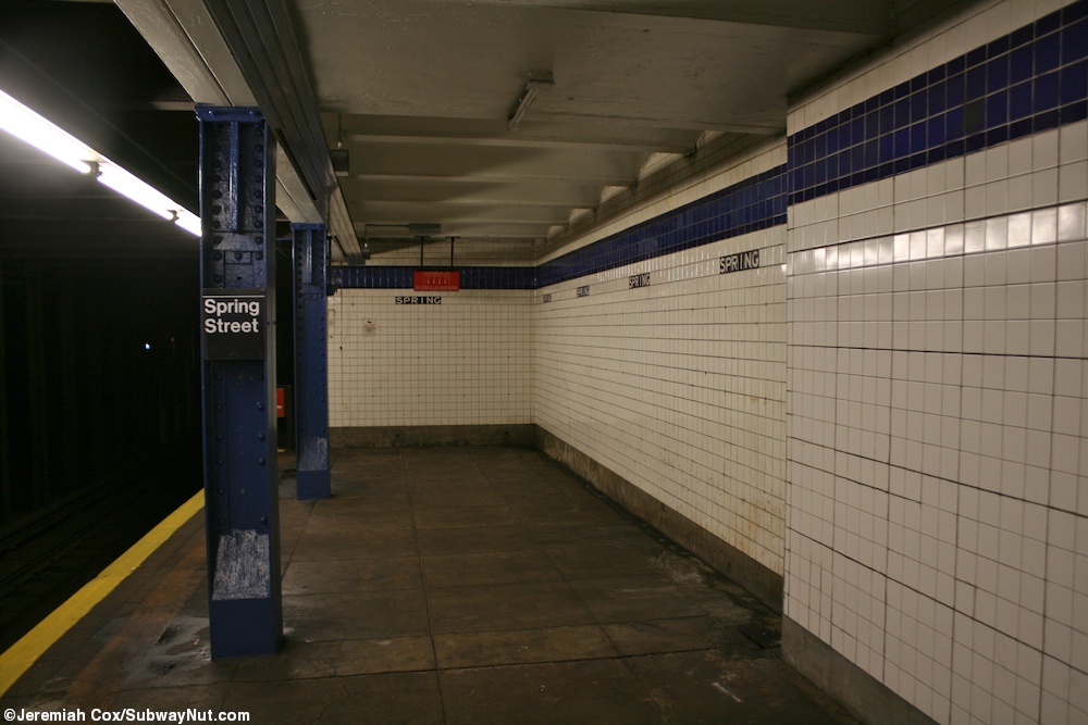
Wall tiling suggests that fare controls and a crossunder have been removed from the north end of the station. The platforms have a blue trim line on a dark blue border (ultramarine blue and cobalt blue, with replacement tiles at the north end that are ultramarine blue and navy blue).[8] The name tablets consist of "SPRING ST" in white sans-serif font on a dark blue background with a lighter blue border. Beneath the trim line and name tablets are "SPRING" and directional signs in white lettering on a black border tiled onto the walls.[9] Blue I-beam columns run along the entire length of both platforms, with every other one having the standard black and white station signs.[10]
Exits
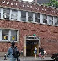
All fare control areas are at platform level. The station's main ones are at the south end of the platform. Each contains banks of regular and HEET turnstiles, a token booth, and a single staircase going up to Spring Street and Sixth Avenue. The one on the northbound side is built inside a school building and leads to the northeast corner while the one on the southbound side leads to the northwest corner.[11] The southbound platform has an un-staffed HEET entrance that has a single staircase going up to the southwest corner of Vandam Street and Sixth Avenue.[11] There are also closed fare control areas at the north end of the station, which led to all four corners of the intersection of Prince Street/Charlton Street and Sixth Avenue.[7]
Artwork

In December 1984, Chilean artist Alfredo Jaar rented all the ad space in the station for the month, and put up an installation he called "Rushes", which showed 81 photos he had taken of poor Brazilian workers digging in Serra Pelada, a government-run gold mine. Scattered amongst them were signs giving world oil prices.[12][13][14]
The 1994 artwork installed at the stairway of the northbound platform's fare control is a large, lively mosaic called New York City Subway Station by Edith Kramer.[15] It consists of a single painting depicting 14th Street–Union Square on the IRT Lexington Avenue Line.[15]
References
- 1 2 New York Times, List of the 28 Stations on the New Eighth Ave Line, September 10, 1932, page 6
- ↑ "Station Developers' Information". Metropolitan Transportation Authority. Retrieved June 13, 2017.
- ↑ "NYC Subway Wireless – Active Stations". Transit Wireless Wifi. Retrieved May 18, 2016.
- ↑ "Facts and Figures: Annual Subway Ridership 2012–2017". Metropolitan Transportation Authority. July 12, 2018. Retrieved July 12, 2018.
- ↑ Crowell, Paul (September 10, 1932). "Gay Midnight Crowd Rides First Trains In The New Subway: Throngs at Station an Hour Before Time, Rush Turnstiles When Chains are Dropped" (PDF). New York Times. Retrieved November 8, 2015.
- ↑ "C Train". Stationreporter.net. Archived from the original on March 13, 2013. Retrieved February 15, 2013.
- 1 2 "Review of the A and C Lines" (PDF). Metropolitan Transportation Authority. December 11, 2015. Retrieved January 19, 2016.
- ↑ "IND Station Tile Colors". www.nycsubway.org. Retrieved February 15, 2013.
- ↑ Cox, Jeremiah (May 24, 2010). "A Spring St name tablet on the downtown platform with exit text to Vandam". subwaynut.com. Retrieved April 2, 2018.
- ↑ Cox, Jeremiah (January 2, 2011). "The extreme northern end of the uptown platform tiling gets back to normal". subwaynut.com. Retrieved April 2, 2018.
- 1 2 "MTA Neighborhood Maps: SoHo / Tribeca" (PDF). Metropolitan Transportation Authority. 2015. Retrieved August 6, 2015.
- ↑ Michael W. Brooks. Subway City: Riding the Trains, Reading New York. Retrieved February 14, 2013.
- ↑ Tracy Fitzpatrick (May 30, 2009). Art and the Subway: New York Underground. Retrieved February 14, 2013.
- ↑ "IN THE SUBWAYS; A Little Digging Yields Clues to the Revolution". Retrieved February 15, 2013.
- 1 2 "subway station art". Ephemeral New York. Retrieved February 15, 2013.
External links
| Wikimedia Commons has media related to Spring Street (IND Eighth Avenue Line). |
- nycsubway.org – IND 8th Avenue: Spring Street
- nycsubway.org — New York Subway Station Artwork by Edith Kramer (1994)
- Station Reporter — C Train
- Station Reporter — E Train
- Spring Street entrance from Google Maps Street View
- Vandam Street entrance from Google Maps Street View
- Platform from Google Maps Street View